WCF SECTION SPECIAL BULLETIN #21-04 – 1800 EDT – 7/04/21

TROPICAL STORM ELSA – 1800 EDT – 7/04/21

Elsa is now nearing the southern coastline of Cuba and is expected to skirt along the Cuban coastline before making landfall and crossing Cuba into the Gulf of Mexico.  The forecast path has had no significant changes since the last bulletin yesterday evening. Elsa is now moving NW around the periphery of the upper level subtropical ridge that is over the western Atlantic off the east coast of Florida, and then enter the Gulf of Mexico and go north in the eastern Gulf of Mexico and making a second landfall on the Florida west coast, most likely just north of the Tampa Bay Area.  According to the Forecast Discussion issued by the National Weather Service Office in Ruskin this afternoon, “There is risk of tropical storm conditions, storm surge, and rainfall impacts along the west coast of Florida beginning as early as Monday night and lasting through Wednesday.”.  Impacts to the ARRL West Central Florida Section now seem more likely in the coastal counties, but the possible storm path still covers all of the ARRL West Central Florida Section.

SUMMARY OF 500 PM EDT…2100 UTC…INFORMATION

———————————————-
LOCATION…19.8N 77.9W
ABOUT 15 MI…20 KM W OF CABO CRUZ CUBA
ABOUT 110 MI…180 KM S OF CAMAGUEY CUBA
MAXIMUM SUSTAINED WINDS…60 MPH…95 KM/H
PRESENT MOVEMENT…NW OR 310 DEGREES AT 14 MPH…22 KM/H
MINIMUM CENTRAL PRESSURE…1009 MB…29.80 INCHES
SUMMARY OF WATCHES AND WARNINGS IN EFFECT:

A Tropical Storm Warning is in effect for…
* The Cuban provinces of Camaguey, Granma, Guantanamo, Holguin, Las Tunas, Santiago de Cuba, Ciego de Avila, Sancti Spiritus, Villa Clara, Cienfuegos, Matanzas, Mayabeque, and Havana
* Jamaica
* The Florida Keys from Craig Key westward to the Dry Tortugas

A Hurricane Watch is in effect for…
* The Cuban provinces of Camaguey, Granma, Guantanamo, Holguin, Las Tunas, and Santiago de Cuba

A Storm Surge Watch is in effect for…
* West coast of Florida from Bonita Beach to the Suwannee River

A Tropical Storm Watch is in effect for…
* Cayman Brac and Little Cayman
* The Cuban province of Artemisa
* The Florida Keys from east of Craig Key to Ocean Reef
* Florida Bay
* West coast of Florida from Flamingo northward to the Anclote River

DISCUSSION:

The following excerpt is from the Forecast Discussion issued at 1700 EST today, “Elsa continues to exhibit some well-defined convective banding features over the northern and eastern portions of the circulation. Dvorak current intensity estimates from TAFB and SAB are 45 and 55 kt respectively,so the advisory intensity remains at 50 kt. Although the cirrus-level outflow over the area looks fairly impressive, the SHIPS output diagnoses about 20 kt of vertical shear over the cyclone, which may be inhibiting strengthening. Another negative factor could be blockage of the low-level inflow by the land masses surrounding the cyclone.

The storm has turned toward the northwest, and the initial motion estimate is now 310/12 kt. There is little change to the track forecast reasoning from the previous advisory package. Elsa should move around the western periphery of a mid-level subtropical high pressure area during the next 3 days or so. Thereafter, the system should accelerate northward to northeastward over the eastern United States and the northwest Atlantic. No significant changes have been made to the NHC track forecast, which remains close to the simple and correct model consensus solutions.

Some strengthening could occur as the storm approaches the south coast of Cuba and although not explicitly shown in the official forecast, Elsa could strengthen to near 60 kt before landfall in that country. Over the eastern Gulf of Mexico, southwesterly shear is expected to limit strengthening. The official intensity forecast remains on the high side of the numerical model guidance.”

SITUATION AND ACTIONS:

At the present time, A Tropical Storm Watch has been issued from the Anclote River south through approximately the northern one-third of the Florida Keys.  A Tropical Storm Warning is in effect for the southern two-thirds of the Florida Keys.  A Storm Surge Warning is in effect for Bonita Springs to the Suwanee River including Tampa Bay.

In the ARRL West Central Florida Section, A Tropical Storm Watch and a Storm Surge Watch is in effect for Pinellas, Hillsborough, Manatee, Sarasota, and Charlotte Counties.

As of press time, there have not been any requests for communications assistance from any ARES or CERT group in the ARRL West Central Florida Section.  All of the ARES groups in the ARRL West Central Florida Section have been taking preparedness actions with their equipment and supplies, and monitoring the situation carefully, just in case they are requested to active by their various served agencies.

All ARES, ACS, and CERT personnel should monitor their email and phones for any requests for assistance from their served agencies through their respective chains of command.  All ARES, ACS, and CERT personnel should perform any last minute checks on equipment and or supplies in case of activation.  Please do not self-activate as requests for assistance and or mutual assistance must follow through the proper procedure.  Any personal preparedness activities should be nearing completion.  Everyone is highly encouraged to continue to check each advisory issued by the National Hurricane Center in Miami and any advisories or Hurricane Local Statements issued by the National Weather Service Office in Ruskin.

LATEST NATIONAL HURRICANE CENTER INFORMATION:

Public Advisories:  https://www.nhc.noaa.gov/text/refresh/MIATCPAT4+shtml/052330.shtml?
Forecast Advisory:  https://www.nhc.noaa.gov/text/refresh/MIATCMAT4+shtml/052053.shtml?
Forecast Discussion:  https://www.nhc.noaa.gov/text/refresh/MIATCDAT4+shtml/052054.shtml?

CONCLUSION

The next WCF SECTION SPECIAL BULLETIN will be issued around 1800 EST tomorrow evening, following the 1700 EDT advisory on Hurricane Elsa, unless conditions warrant a sooner release.

END OF SPECIAL BULLETIN

WCF SECTION SPECIAL BULLETIN #21-03 – 1800 EDT – 7/03/21

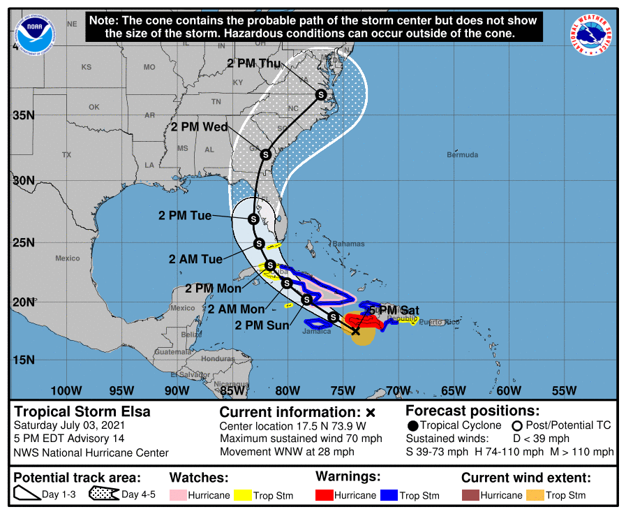
TROPICAL STORM ELSA – 1800 EDT – 7/03/21

Elsa was downgraded to a high end tropical storm from a low end Category 1 hurricane this morning but still has winds near Tropical Storm force right near the center.  The forecast path has had only minor changes since the last bulletin yesterday evening. Elsa is continuing WNW around the periphery of the upper level subtropical ridge that is over the western Atlantic off the east coast of Florida.    The timing of the eventual northwest and north turn will depend upon how far the current trough of low pressure digs into the southeastern United States and how much that trough erodes the upper level subtropical ridge east of the State of Florida.   Impacts to the ARRL West Central Florida Section now seem more likely in the coastal counties, but the possible storm path still covers all of the ARRL West Central Florida Section.

SUMMARY OF 500 PM EDT…2100 UTC…INFORMATION

———————————————-
LOCATION…17.5N 73.9W
ABOUT 130 MI…210 KM SW OF PORT AU PRINCE HAITI
ABOUT 195 MI…310 KM E OF KINGSTON JAMAICA
MAXIMUM SUSTAINED WINDS…70 MPH…110 KM/H
PRESENT MOVEMENT…WNW OR 290 DEGREES AT 28 MPH…44 KM/H
MINIMUM CENTRAL PRESSURE…1000 MB…29.53 INCHES


SUMMARY OF WATCHES AND WARNINGS IN EFFECT:

A Hurricane Warning is in effect for…
* Southern portion of Haiti from Port Au Prince to the southern border with the Dominican Republic.

A Tropical Storm Warning is in effect for…
* The coast of Haiti north of Port Au Prince
* Southern coast of Dominican Republic from Punta Palenque to the border with Haiti
* The Cuban provinces of Camaguey, Granma, Guantanamo, Holguin, Las Tunas, Santiago de Cuba, Ciego de Avila, Sancti Spiritus, Villa Clara, and Cienfuegos
* Jamaica

A Hurricane Watch is in effect for…
* The Cuban provinces of Camaguey, Granma, Guantanamo, Holguin, Las Tunas, and Santiago de Cuba

A Tropical Storm Watch is in effect for…
* South coast of the Dominican Republic east of Punta Palenque to Cabo Engano
* Cayman Brac and Little Cayman
* The Cuban provinces of Matanzas, Mayabeque, and Havana
* The Florida Keys from Craig Key westward to the Dry Tortugas

DISCUSSION:

The following excerpts are from the Forecast Discussion issued at 1700 EST today, “Satellite imagery shows that Elsa looks ragged and disorganized at this time, with bursts  of convection occuring near the low-level center and poorly-defined convective banding. Some of this is likely due to the the proximity of the system to Hispaniola. Air Force Reserve and NOAA Hurricane Hunter aircraft have reported reliable 55-60 kt surface wind estimates from the SFMR, along with the latest central pressure report of 1000 mb. The initial intensity remains 60 kt based mainly on the SFMR data.

The initial motion is now 295/24. There is little change in the forecast philosophy from the previous advisory. Elsa is approaching a weakness in the subtropical ridge caused by a  large baroclinic trough over the eastern United States. The global models forecast this trough to move eastward into the Atlantic, but the southern portion is likely to split off and become an upper-level low pressure area over the western Gulf of Mexico, with the subtropical ridge over the Atlantic situated to the east of the this low. In response, Elsa should slow its forward motion and turn northwestward during the next 48 h, followed by a general northward motion from 60-96 h and recurvature into the westerlies after that time. The forecast track takes the center near or over southwestern Haiti, Cuba, and the eastern Gulf of Mexico or the Florida Peninsula during the next 3 days or so. After that, the
system is likely to cross portions of the southeastern United States on its way into the Atlantic. The new forecast track is changed little from the previous advisory, and it lies near the center of the now reasonably-agreeing track guidance envelope.

In addition to land interaction, Elsa continues to be affected by northwesterly shear that is at least partly due to the fast low-level flow that the storm is embedded in. Some shear is
expected to continue through the next 72 h. However, once the system passes the southwestern peninsula of Haiti, there may be less land interaction than previously forecast. The intensity guidance is in good agreement on weakening during the next 48 h, and the GFS, UKMET, and ECMWF show Elsa as a not very vertically aligned system
with some separation between the low- and mid-level centers over the southeastern Gulf of Mexico. After that, despite the shear, upper-level divergence associated with the aforementioned upper-level low could allow for some re-intensification as forecast by the HWRF and other models. The new NHC intensity forecast calls for some weakening in the first 48 h and then shows re-intensification over the Gulf of Mexico. Through the first 72 h,
the forecast remains at the upper edge of the intensity guidance.

Hurricane warnings remain in effect for portions of Haiti at this time, as there is still the possibility that a short-lived re-intensification might occur due to a convective burst.

Given the remaining uncertainty in the track forecast and the degree of land interaction with Hispaniola and Cuba, users are urged to factor in some of this uncertainty. For reference, average NHC track errors at days 3 and 4 are 125 miles and 150 miles,
respectively. The average NHC intensity errors are around 15 mph for both days 3 and 4.

SITUATION AND ACTIONS:

At the present time, the only watch or warning for the State of Florida is a Tropical Storm Watch in The Florida Keys from Craig Key westward to the Dry Tortugas.  At the present time there are no watches or warning for any county in the ARRL West Central Florida Section.

As of press time, there have not been any requests for communications assistance from any ARES or CERT group in the ARRL West Central Florida Section.  All of the ARES groups in the ARRL West Central Florida Section have been taking preparedness actions with their equipment and supplies, and monitoring the situation carefully, just in case they are requested to active by their various served agencies.

All ARES, ACS, and CERT personnel should monitor their email and phones for any requests for assistance from their served agencies through their respective chains of command.  All ARES, ACS, and CERT personnel should perform any last minute checks on equipment and or supplies in case of activation.  Please do not self-activate as requests for assistance and or mutual assistance must follow through the proper procedure.  Any personal preparedness activities should be brought to completion in the next 24 hours. Everyone is highly encouraged to continue to check each advisory issued by the National Hurricane Center in Miami and any advisories or Hurricane Local Statements issued by the National Weather Service Office in Ruskin.

LATEST NATIONAL HURRICANE CENTER INFORMATION:

Public Advisories:  https://www.nhc.noaa.gov/text/refresh/MIATCPAT4+shtml/052330.shtml?
Forecast Advisory:  https://www.nhc.noaa.gov/text/refresh/MIATCMAT4+shtml/052053.shtml?
Forecast Discussion:  https://www.nhc.noaa.gov/text/refresh/MIATCDAT4+shtml/052054.shtml?

CONCLUSION

The next WCF SECTION SPECIAL BULLETIN will be issued around 1800 EST tomorrow evening, following the 1700 EDT advisory on Hurricane Elsa, unless conditions warrant a sooner release.

END OF SPECIAL BULLETIN

WCF SECTION SPECIAL BULLETIN #21-02 – 2330 EDT – 7/02/21

HURRICANE ELSA – 2300 EDT – 7/02/21

Elsa, which formed in the Atlantic east of the Windward/Leeward Islands on Wednesday June 30, became a low end Category Hurricane this morning.  Elsa is continuing WNW around the periphery of the upper level subtropical ridge that is over the western Atlantic off the east coast of Florida.    The timing of the eventual northwest and north turn will depend upon how far the current trough of low pressure digs into the southeastern United States and how much that trough erodes the upper level subtropical ridge east of the State of Florida.   Impacts to the ARRL West Central Florida Section are far from certain at this point.  Therefore with the potential impacts to the State of Florida and the ARRL West Central Florida Section, WCF SECTION SPECIAL BULLETINS on Elsa will now commence.

SUMMARY OF 1100 PM EST…0300 UTC…INFORMATION

———————————————-
LOCATION…14.8N 66.3W
ABOUT 395 MI…635 KM ESE OF ISLA BEATA DOMINICAN REPUBLIC
ABOUT 730 MI…1175 KM ESE OF KINGSTON JAMAICA
MAXIMUM SUSTAINED WINDS…80 MPH…130 KM/H
PRESENT MOVEMENT…WNW OR 285 DEGREES AT 29 MPH…46 KM/H
MINIMUM CENTRAL PRESSURE…995 MB…29.39 INCHES

SUMMARY OF WATCHES AND WARNINGS IN EFFECT:

A Hurricane Warning is in effect for…
* Southern coast of Dominican Republic from Punta Palenque to the
border with Haiti
* Southern portion of Haiti from Port Au Prince to the southern
border with the Dominican Republic
* Jamaica

A Tropical Storm Warning is in effect for…
* The coast of Haiti north of Port Au Prince
* South coast of the Dominican Republic east of Punta Palenque to
Cabo Engano

A Hurricane Watch is in effect for…
* The Cuban provinces of Camaguey, Granma, Guantanamo, Holguin,
Las Tunas, and Santiago de Cuba

A Tropical Storm Watch is in effect for…
* North coast of the Dominican Republic from Cabo Engano to
Bahia de Manzanillo
* Cayman Brac and Little Cayman]

DISCUSSION:

The following excerpts are from the Forecast Discussion issued at 1600 EST today, “Data from an Air Force Reserve hurricane hunter aircraft indicate that Elsa has weakened slightly, and that the flight-level and surface centers are not vertically aligned. The maximum 700-mb wind speed measured was 75 kt and the highest SFMR surface wind sampled was 61 kt in the northeastern quadrant. However, these data were collected outside of the strongest convection that was occurring just east of the flight track, so the intensity has only been lowered to 70 kt, which is supported by the slightly higher central pressure of 995 mb sampled by a dropsonde.

The initial motion estimate now is 285/25 kt. There remains little significant change to the previous track forecast or reasoning. The latest 00Z model guidance has become more convergent and now lies nearly on top of the previous advisory track. Over the last 48 h, the ECMWF model has steadily shifted Elsa’s track westward by about 1 degree of longitude each model cycle, with the latest ECMWF forecast track now being located about 240 nmi west of its forecast track two days ago. As a result, less weight has been placed on the ECMWF solution for this advisory. However, even its latest solution no longer takes Elsa over the heart of Hispaniola. Elsa should continue to move generally west-northwestward for the next 48 h, accompanied by a slow but steady decrease in forward speed. By the time the hurricane nears southern Cuba, the forward speed should be less than 15 kt. Thereafter, Elsa should gradually turn northwestward and eventually northward through a developing weakness in the subtropical ridge This motion should take Elsa across Cuba and over the eastern Gulf of Mexico or the nearby Florida Peninsula on day 4, followed by a motion over the coastal regions of the southeastern United States on day 5. The new NHC forecast track is essentially just an update of the previous advisory, and closely follows a blend of the GFS, UKMET, and HWRF models, and the TVCA
simple consensus model.

Elsa’s fast forward speed and recent entrainment of dry mid-level air into the western semicircle has eroded some of the inner-core convection, resulting in the aforementioned weakening. In fact, NOAA G-IV dropsondes launched around 2100 UTC northwest of Elsa indicated a significant dry-air layer between 400-500-hPa that may have been imported by moderate northwesterly mid-level shear. However, as the cyclone’s forward speed steadily decreases, the low-, mid-, and upper-level circulations should become more vertically aligned, which should allow for at least some slight re-strengthening during the next 24 h or so. Possible interaction with the landmasses of Haiti, southeastern Cuba, and Jamaica is the primary reason for not showing a more robust intensity forecast given the very warm water beneath the hurricane and a very favorable upper-level wind flow regime. The latest GFS and UKMET models indicate that Elsa will be moving into the center of a 300-200-mb synoptic-scale anticyclone, which would produce enhanced outflow jets to the north and south of the cyclone, resulting in significant strengthening. If Elsa ends up ‘threading-the-needle’ between Haiti, Jamaica, and Cuba, then subsequent intensity forecasts may have to be increased similar to the much stronger HWRF model. For now, the official NHC intensity forecast maintains continuity with the previous advisory, and shows only slight re-strengthening due to possible interaction with land.”

SITUATION AND ACTIONS:

At the present time, there are no watches or warning for either the State of Florida or the ARRL West Central Florida Section.

As of press time, there have not been any requests for communications assistance from any ARES or CERT group in the ARRL West Central Florida Section,

All ARES, ACS, and CERT personnel should monitor their email and phones for any requests for assistance from their served agencies via their respective chains of command.  All ARES, ACS, and CERT personnel should perform any last minute checks on equipment and or supplies in case of activation.  Please do not self-activate as requests for assistance and or mutual assistance must follow through the proper procedure.  Any personal preparedness activities should be brought to completion in the 24 to 48 hours. Everyone is highly encouraged to continue to check each advisory issued by the National Hurricane Center in Miami and any advisories issued by the National Weather Service Office in Ruskin.

LATEST NATIONAL HURRICANE CENTER INFORMATION:

Public Advisories:  https://www.nhc.noaa.gov/text/refresh/MIATCPAT4+shtml/052330.shtml?
Forecast Advisory:  https://www.nhc.noaa.gov/text/refresh/MIATCMAT4+shtml/052053.shtml?
Forecast Discussion:  https://www.nhc.noaa.gov/text/refresh/MIATCDAT4+shtml/052054.shtml?

CONCLUSION

The next WCF SECTION SPECIAL BULLETIN will be issued around 1800 EST tomorrow evening, following the 1700 EDT advisory on Hurricane Elsa, unless conditions warrant a sooner release.

END OF SPECIAL BULLETIN

WCF SECTION PRESS RELEASE #21-28

NEW EMERGENCY COORDINATOR FOR PASCO COUNTY APPOINTED

On Tuesday June 1, 2021, Mike Douglas W4MDD, Section Manager of the ARRL West Central Florida Section, appointed Bill Fetta N7CGC to be the new ARRL Emergency Coordinator for Pasco County. Fetta succeeds Ralph McCullough WA3YFQ, who had been ARRL Emergency Coordinator since August 2017.  McCullough is continuing his service as an Assistant Emergency Coordinator for Pasco County ARES.

Fetta was first licensed in November of 2017, not long after the landfall and passage of Hurricane Irma.  The impact of Hurricane Irma had a great impact upon Fetta, and having extensive experience in communications in the United States Coast Guard, decided to obtain his amateur radio license in order to provide public service through the ARES program.  Fetta had served as an Assistant Emergency Coordinator for Pasco County ARES prior to be appointed as Emergency Coordinator.

Fetta made the following comments on what motivated him to become licensed and on his appointment as ARRL Emergency Coordinator, “My welcome to FL was Irma. I found myself sitting in the bleachers while the big game was on and holding a unique skillset that was not in the game but should have been.  There are no words to describe that feeling…That was my sole reason for obtaining an amateur license but I was to find that it opened the door to so much more…I look at the talent and experience across WCF ARES and for me it is remarkable!!  I am very proud of our group and all of you.  No one person has all the answers, including me.  But together we do .. after all this is WCF and if we had to radiate a car bumper to stay in the game we’d find a way.  Adapt, Improvise, overcome!”

Fetta”s professional career included 23 many years of service in the Coast Guard and the Montana Army National Guard, with much of that time in radio communications.  After retiring from his military service, Fetta had a business as a sub-contractor and a painting contractor until his full time retirement.

END OF PRESS RELEASE

WCF SECTION SPECIAL BULLETIN #21-01

WCF SECTION FIELD DAY CARAVAN IS EN ROUTE WITH APRS TRACKING ENABLED.

The 21st Annual ARRL West Central Florida Section Field Day Caravan, consisting of Mike Douglas W4MDD, our Section Manager, and Tim Peters KW4AJ, his very capable chauffeur, got underway at approximately 0918 hours this morning from out eastern Polk County.  The general path of the caravan will be to go to Charlotte County and then work their way north through the coastal counties of the ARRL West Central Florida Section and then wind up in Pasco County before proceeding back to Polk County.

You may follow the progress of the carvan via APRS at the following website:  http://aprs.fi/w4mdd-10.

END OF SPECIAL BULLETIN

WCF SECTION PRESS RELEASE #21-27

WCF SECTION FIELD DAY IN PERSON CARAVAN RESUMES AND SPECIAL FIELD DAY EDITION OF EAGLE NET.

The 21st Annual ARRL West Central Florida Section Field Day Caravan will take to the roads of the ARRL West Central Florida Section on Saturday June 26, 2021.  Mike Douglas W4MDD, Section Manager, and his chauffeur Tim Peters KW4AJ, will be conducting the caravan solo this year, due to the limited number of clubs and groups who registered their Field Day operations with the ARRL Field Day Locator on the ARRL website.  Due to COVID-19 restrictions, the 2020 edition of the ARRL West Central Florida Section Field Day Caravan was a virtual only event conducted via a Zoom meeting.

The Eagle Net, which meets daily on the NI4CE Repeater System at 2030 hours, will operate an extended session on Saturday June 26, 2021 to handle any NTS radiograms originated from Field Day sites and specifically for any NTS radiograms being sent to our Section Manager Mike Douglas W4MDD or our Section Emergency Coordinator Norman Xanders WX4NEX.

For more information on how to format an NTS Radiogram to the Section Manager or the Section Emergency Coordinator, which includes a sample radiogram, there are instructions and guidance on the ARRL West Central Florida Section Field Day Caravan webpage at http://arrlwcf.org/wcf-special-events/west-central-florida-section-field-day-caravan/

The ARRL West Central Florida Section wishes everyone a safe and successful ARRL Field Day.

END OF PRESS RELEASE


WCF SECTION PRESS RELEASE #21-26

UPDATE AND CORRECTIONS FOR MAY/JUNE WCF PRESSER. CALL FOR ARTICLES FOR JULY WCF PRESSER

Due to minor corrections and a few articles that came in at the last minute, a revised edition of Issue 59 for May/June 2021 has been uploaded to the Section website and is available for download.

We are shifting the publication dates for the WCF PRESSER starting with the July WCF PRESSER.  It will be similar to the dissemination timeframe for QST.  The new target date for publication will be on the 20th of the month preceding the month of the issue. For example, the July issue will be around June 20th.  This will allow the timely reception and inclusion of any news or announcements of upcoming events that are received from monthly club or group newsletters.

As a result of the July WCF PRESSER issue to be published around June 20th, a call is being issued for inclusion of any articles for publication in the July WCF PRESSER.  You may send those articles to JIm Weslager K3WR via email at weslager@gmail.com or Darrell Davis KT4WX via email at kt4wx@arrl.net.

END OF PRESS RELEASE

WCF SECTION PRESS RELEASE #21-25

SECTION WEBSITE FORMS REPLACED

The online forms on the ARRL West Central Florida Section website that have been not been operating properly, have been completely replaced and are now fully functional.  Darrell Davis KT4WX, Assistant Section Manager for Technology, had the following comments on the new website forms, “All the problems with our online forms began last December with an upgrade to WordPress, and finally stop functioning completely just recently.  A new forms plugin has been installed, and all the forms had to recreated from scratch.  All the forms on the Section website are now fully functional.  They will give you a brief on screen confirmation and an email confirmation shortly afterward as they did before.”

Some minor adjustments will need to be made in the next few days on the back end. If you are an ARRL Station Appointee, please go ahead and do your monthly reports. If there are any issues with any of the forms, please contact Darrell Davis KT4WX at kt4wx@arrl.net and explain any issues you may be having, so any problems may be corrected.

END OF PRESS RELEASE

WCF SECTION PRESS RELEASE #21-24

THE WCF PRESSER ISSUE #59 FOR MAY/JUNE 2021 IS NOW PUBLISHED

The WCF PRESSER Issue #59 for May/June 2021, has been published on the Section website.  An announcement of the publication of the WCF PRESSER will be disseminated on the ARRL remailer shortly. If anyone has any information that is amateur radio related that you would like to go into the next issue of THE WCF PRESSER, please send that to our newsletter editor, Jim Weslager K3WR via email at weslager@gmail.com.

For the PDF version of this newsletter and past issues in PDF format go to http://arrlwcf.org/home/the-wcf-section-presser-arrl-west-central-florida-section-news/.

END OF PRESS RELEASE

WCF SECTION PRESS RELEASE #21-23

NEW SECTION EMERGENCY COORDINATOR APPOINTED

On Tuesday May 4, 2021, Mike Douglas W4MDD, Section Manager of the ARRL West Central Florida Section, appointed Norman Xanders WX4NEX to be the new Section Emergency Coordinator for the ARRL West Central Florida Section.  Xanders succeeds Ben Henley KI4IGX, who had been Section Emergency Coordinator since January 2015 and has been in poor health recently.

Xanders was originally licensed in late 2016. Xanders has been a storm chaser for over 20 years here in central Florida, specifically in Polk County. One day Xanders got the RadarScope app for his smartphone and was looking at other Spotters on the map and saw some with call signs, inquired into it, and found out they were part of a Skywarn Net. This is where Xanders began his amateur radio journey. Since becoming licensed, Xanders has volunteered extensively for Polk County ARES as a net control operator. Xanders then became an Assistant Net Manager, and then Net Manager for the Polk County ARES Net. In 2019, Xanders became the Assistant Emergency Coordinator for Operations for Polk County ARES. Xanders also serves as a net control station for the National Weather Service SKYWARN Information Net, which is held on the NI4CE Repeater System every Tuesday at 2100 hours.  Recently, Xanders had been appointed and was serving as an Assistant Section Manager as Liaison to the National Weather Service Office in Ruskin.

END OF PRESS RELEASE

1 10 11 12 13 14 49