WCF SECTION SPECIAL BULLETIN #23-04 – 2100 EDT – 8/29/23

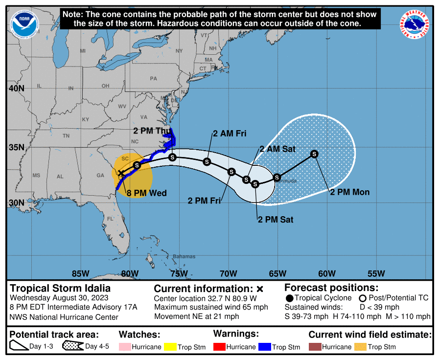
HURRICANE IDALIA – 2100 EST – 8/29/23

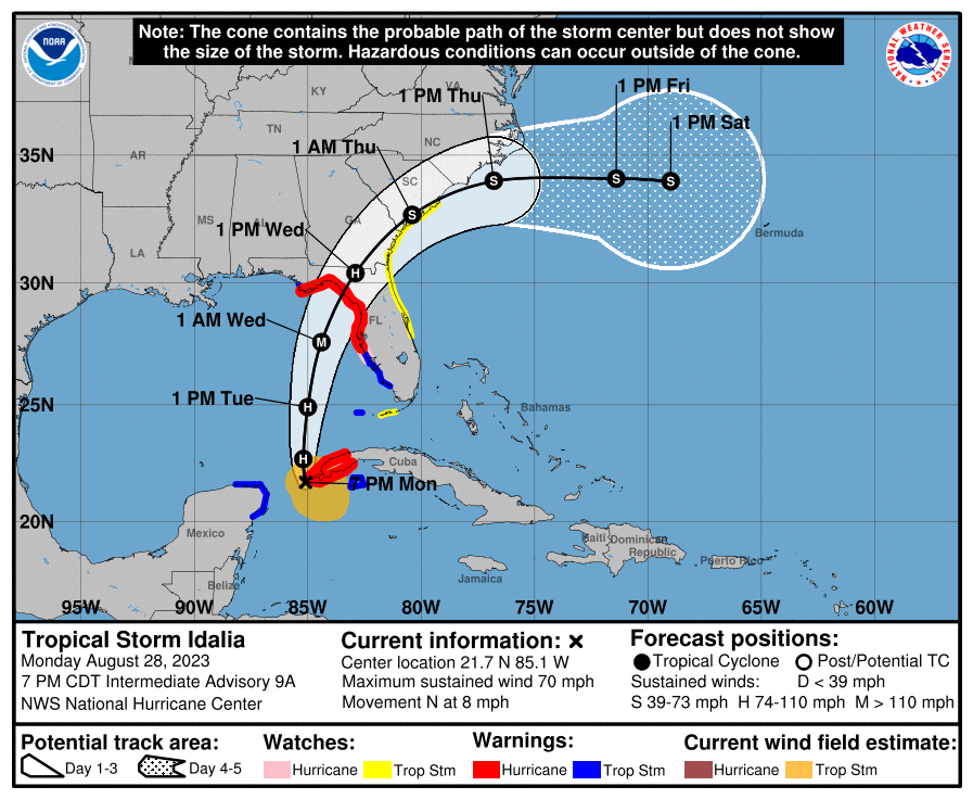
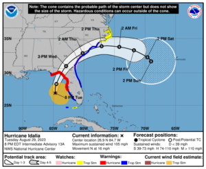
Hurricane Idalia (pronounced ee-DAL-ya), which was declared a hurricane at 0500 EDT today, is continuing its northward track.  Currently Hurricane Idalia is due west of the Port Charlotte area of Charlotte out in the eastern Gulf of Mexico and headed in a northerly direction at about 16 miles per hour.  Tropical Storm Idalia is expected to continue to strengthen as it moves north in the southern Gulf of Mexico caught between high pressure to the east and low pressure to the west.  Idalia is expected to strengthen into a Category 3 hurricane before making landfall in the big bend area of Florida on Wednesday morning after sunrise, and by Wednesday evening the center of Idalia is forecast to be over southeastern Georgia.

COASTAL WATCHES/WARNINGS AND FORECAST CONE FOR STORM CENTER

SUMMARY OF 2000 EST…0000 UTC…INFORMATION

——————————————————————————-
LOCATION…26.9N 84.7W
ABOUT 155 MI…250 KM WSW OF TAMPA FLORIDA
ABOUT 245 MI…390 KM S OF TALLAHASSEE FLORIDA
MAXIMUM SUSTAINED WINDS…105 MPH…165 KM/H
PRESENT MOVEMENT…N OR 10 DEGREES AT 16 MPH…26 KM/H
MINIMUM CENTRAL PRESSURE…965 MB…28.50 INCHES

SUMMARY OF WATCHES AND WARNINGS IN EFFECT:

A Tornado Watch effective until 0600 EDT tomorrow for the following counties in Florida…
*ALACHUA, CHARLOTTE, CITRUS, DESOTO, DIXIE, GILCHRIST, HARDEE, HERNANDO,   HIGHLANDS, HILLSBOROUGH, LAFAYETTE, LAKE, LEE, LEVY, MANATEE, MARION, PASCO, PINELLAS, POLK, SARASOTA, SUMTER, and TAYLOR.

A Storm Surge Warning is in effect for…
* Englewood northward to Indian Pass, including Tampa Bay

A Hurricane Warning is in effect for…
* Middle of Longboat Key northward to Indian Pass, including Tampa Bay

A Tropical Storm Warning is in effect for…
* Dry Tortugas Florida
* Chokoloskee northward to the Middle of Longboat Key
* West of Indian Pass to Mexico Beach
* Sebastian Inlet Florida to Surf City North Carolina

A Storm Surge Watch is in effect for…
* Bonita Beach northward to Englewood, including Charlotte Harbour
* Mouth of the St. Mary’s River to South Santee River South Carolina
* Beaufort Inlet to Drum Inlet North Carolina
* Neuse and Pamlico Rivers North Carolina

A Hurricane Watch is in effect for…
* Mouth of the St. Mary’s River to Edisto Beach South Carolina

A Tropical Storm Watch is in effect for…
* Lower Florida Keys west of the west end of the Seven Mile Bridge
* North of Surf City North Carolina to the North Carolina/Virginia
border
* Pamlico and Albemarle Sounds

A Hurricane Warning means that hurricane conditions are expected somewhere within the warning area. Preparations to protect life and property should be rushed to completion.

A Storm Surge Warning means there is a danger of life-threatening inundation, from rising water moving inland from the coastline, during the next 36 hours in the indicated locations. For a depiction of areas at risk, please see the National Weather Service Storm Surge Watch/Warning Graphic, available at https://hurricanes.gov. This is a life-threatening situation. Persons located within these areas should take all necessary actions to protect life and property from rising water and the potential for other dangerous conditions. Promptly follow evacuation and other instructions from local officials.

A Tropical Storm Warning means that tropical storm conditions are expected somewhere within the warning area.

A Storm Surge Watch means there is a possibility of life-threatening inundation, from rising water moving inland from the coastline, in the indicated locations during the next 48 hours.  For a depiction of areas at risk, please see the National Weather Service Storm Surge Watch/Warning Graphic, available at https://hurricanes.gov.

A Hurricane Watch means that hurricane conditions are possible within the watch area.

A Tropical Storm Watch means that tropical storm conditions are possible within the watch area, generally within 48 hours.

FORECAST DISCUSSION:

The following excerpt is from the Forecast Discussion issued at 1700 EDT today:

“The first stages of an eye have been taking shape in visible satellite imagery. The hurricane has a relatively small Central Dense Overcast and a prominent band of deep convection extending over the eastern semicircle, reaching across the Florida peninsula
southward across western Cuba. An Air Force Reserve Hurricane Hunter aircraft just measured a peak 700-mb flight-level wind of 91 kt with the pressure falling to 972 mb. The initial intensity is therefore set at 85 kt.

Idalia is moving faster toward the north, or 360/14 kt, between a mid-level trough over the northwestern Gulf of Mexico and a subtropical ridge over the Greater Antilles. Idalia is expected to continue moving northward and turn north-northeastward as it approaches the Big Bend region of Florida during the next 12-24 hours. There is very little spread among the track guidance, and the NHC official forecast has been placed very close to the HCCA and TVCX consensus aids during the first 24 hours. This has resulted in a westward shift of about 20-25 n mi compared to the previous forecast, although it should be stressed that additional shifts to the track will be possible until the center reaches land.

After landfall, Idalia is expected to turn toward the northeast and then east, moving near or along the coast of Georgia and the Carolinas in 36-48 hours. Uncertainty in the track forecast is still quite large after 48 hours, with many of the global models turning Idalia southward, while some of the regional hurricane models still show the storm moving out to sea. As a result, the official track forecast continues to show slow motion on days 4 and 5.

The 12-hour intensity forecast shows a 100-kt major hurricane. It is imperative to realize that Idalia is expected to continue strengthening beyond that time, possibly close to the 110 kt shown in the previous forecast, before the center reaches land. Weakening is expected after landfall, but due to the system’s expected fast motion, it is possible that Idalia could maintain hurricane intensity as it moves across southern Georgia and approaches the coasts of Georgia and South Carolina. After Idalia’s center moves offshore over the western Atlantic, strong shear is likely to limit re-intensification, and the official forecast essentially flatlines the intensity on days 2-5.”

SITUATION AND ACTIONS:

As of 1700 EDT, the following warnings are still in effect for the ARRL West Central Florida Section:

  • Tropical Storm Warning:  Charlotte, Desoto, Hardee, and Polk Counties.
  • Hurricane Warning:  Pasco, Pinellas, Hillsborough, Manatee, and Sarasota Counties.
  • Storm Surge Warning:  Coastal portions of Pasco, Pinellas, Hillsborough, Manatee, Sarasota, and Charlotte Counties.

Paul Toth NB9X, Assistant Section Manager, has opened the West Central Florida SKYWARN Net on both the NI4CE Analog and NI4CE NXDN repeater systems.  On the NXDN system, the SKWARN Net is active on the new SKYWARN talkgroup of 1299.  Paul is continuing to disseminate the National Hurricane Center advisories on both nets.  For more information on frequencies and coverages of go to:

Due to the ongoing Regional SKYWARN Net, Sanford Wyatt KM4WXX, Net Manager of the Eagle Net that normally runs daily at 2030 hours, announced the Eagle Net will be cancelled for this evening, Tuesday August 29, and possibly Wednesday August 30, if necessary. The Eagle Net will resume normal operation after Tropical Storm Idalia is no longer a threat.

The following ARES Groups have reported that they are currently activated either partially or fully, as of press time:

  • Pasco County ARES.
  • Pinellas County ARES/ACS.
  • Hillsborough County ARES/RACES
  • Manatee County ARES.
  • Sarasota County ARES.
  • Polk County ARES.
  • Desoto County ARES.
  • Hardee County ARES.
  • Charlotte County FLARES.

All ARES, ACS, and CERT personnel should have completed preparations by now and at this point in time should be in a location that is a secure shelter from Idalia until the storm passes.  All ARES, ACS, and CERT personnel are encouraged to continue to check each advisory issued by the National Hurricane Center in Miami on Tropical Depression Ten and the Tropical Weather Outlook issued four times daily by the National Hurricane Center.

LATEST NATIONAL HURRICANE CENTER INFORMATION:

Public Advisories: https://www.nhc.noaa.gov/text/refresh/MIATCPAT2+shtml/072333.shtml?

Forecast Advisory: https://www.nhc.noaa.gov/text/refresh/MIATCMAT2+shtml/072100.shtml?

Forecast Discussion:  https://www.nhc.noaa.gov/text/refresh/MIATCDAT2+shtml/072057.shtml?

Latest GOES Satellite Floater Images and Loop:  https://www.star.nesdis.noaa.gov/GOES/floater.php?stormid=AL172022#navLink.

CONCLUSION

The next WCF SECTION SPECIAL BULLETIN will be issued tomorrow following the 1700 EDT advisory on Hurricane Idalia, unless conditions warrant a sooner bulletin release.

WCF SECTION SPECIAL BULLETIN #23-03 – 2100 EDT – 8/28/23

TROPICAL STORM IDALIA – 2100 EST – 8/28/23

Tropical Storm Idalia (pronounced ee-DAL-ya) began its northward track last night.  Currently Tropical Storm Idalia is just off the west tip of Cuba and headed in a northerly direction at about 8 miles per hour.  Tropical Storm Idalia is expected to continue to strengthen as it moves north in the southern Gulf of Mexico caught between high pressure to the east and low pressure to the west.  Idalia is expected to strengthen into a Category 3 hurricane before making landfall in the big bend area of Florida now on late Wednesday morning.  Landfall is predicted to be slightly sooner than originally forecast.

COASTAL WATCHES/WARNINGS AND FORECAST CONE FOR STORM CENTER

SUMMARY OF 2000 EST…0000 UTC…INFORMATION

——————————————————————————-
LOCATION…21.7N 85.1W
ABOUT 20 MI…30 KM SW OF THE WESTERN TIP OF CUBA
ABOUT 250 MI…400 KM SW OF THE DRY TORTUGAS
MAXIMUM SUSTAINED WINDS…70 MPH…110 KM/H
PRESENT MOVEMENT…N OR 360 DEGREES AT 8 MPH…13 KM/H
MINIMUM CENTRAL PRESSURE…983 MB…29.03 INCHES

SUMMARY OF WATCHES AND WARNINGS IN EFFECT:

A Storm Surge Warning is in effect for…
* Englewood northward to Indian Pass, including Tampa Bay

A Hurricane Warning is in effect for…
* Cuban province of Pinar del Rio
* Middle of Longboat Key northward to Indian Pass, including Tampa Bay

A Tropical Storm Warning is in effect for…
* Yucatan Peninsula from Tulum to Rio Lagartos, including Cozumel
* Isle of Youth Cuba
* Dry Tortugas Florida
* Chokoloskee northward to the Middle of Longboat Key
* West of Indian Pass to Mexico Beach

A Storm Surge Watch is in effect for…
* Chokoloskee northward to Englewood, including Charlotte Harbour
* Mouth of the St. Mary’s River to South Santee River South Carolina

A Hurricane Watch is in effect for…
* Englewood to the Middle of Longboat Key

A Tropical Storm Watch is in effect for…
* Lower Florida Keys west of the west end of the Seven Mile Bridge
* Sebastian Inlet Florida northward to South Santee River South Carolina

A Hurricane Warning means that hurricane conditions are expected somewhere within the warning area. A warning is typically issued 36
hours before the anticipated first occurrence of tropical-storm-force winds, conditions that make outside preparations difficult or dangerous. Preparations to protect life and property should be rushed to completion.

A Storm Surge Warning means there is a danger of life-threatening inundation, from rising water moving inland from the coastline, during the next 36 hours in the indicated locations. For a depiction of areas at risk, please see the National Weather Service Storm Surge Watch/Warning Graphic, available at https://hurricanes.gov. This is a life-threatening situation. Persons located within these areas should take all necessary actions to protect life and property from rising water and the potential for other dangerous conditions. Promptly follow vacation and other instructions from local officials.

A Tropical Storm Warning means that tropical storm conditions are expected somewhere within the warning area.

A Storm Surge Watch means there is a possibility of life-threatening inundation, from rising water moving inland from the coastline, in the indicated locations during the next 48 hours. For a depiction of areas at risk, please see the National Weather Service Storm Surge Watch/Warning Graphic, available at https://hurricanes.gov.

A Hurricane Watch means that hurricane conditions are possible within the watch area.

A Tropical Storm Watch means that tropical storm conditions are possible within the watch area, generally within 48 hours.

FORECAST DISCUSSION:

The following excerpt is from the Forecast Discussion issued at 1700 EDT today:

“The satellite presentation of Idalia has continued to improve this afternoon. The center of the storm is embedded within an area of deep convection with cloud tops colder than -75C. Although the early reconnaissance aircraft and radar data from Cuba have not yet indicated the presence of an eyewall, the aircraft data did indicate that the pressure had fallen to around 987 mb on the final pass through the center earlier this afternoon. Believable SFMR winds of 60 kt were reported to the east of the center, and Idalia’s intensity was raised to that value on the 1800 UTC intermediate advisory and it remains at that value for this advisory. NOAA and Air Force Reserve Hurricane Hunter aircraft are scheduled to be in the storm environment again this evening and should provide additional information on the structure and intensity of the tropical cyclone. Another NOAA G-IV synoptic surveillance mission is underway and that data should be assimilated into the dynamical model runs this evening.

Idalia is moving northward or 360/7 kt. The storm should continue to be steered northward between a mid-level trough over the central Gulf of Mexico and a ridge near the Greater Antilles through tonight. On Tuesday, a faster north-northeastward motion should begin as a trough moves into the east-central United States. This motion should bring the center of Idalia to the Gulf coast of Florida on Wednesday. The dynamical models continue to have some spread after 36 hours, with the GFS and HAFS guidance along the western side of the envelope and the ECMWF along the eastern side. The consensus aids were slightly west of the previous cycle, and the NHC forecast has been nudged in that direction. The NHC track forecast is in best agreement with the HFIP corrected consensus model. It is still worth stressing that only a small deviation in the track could cause a significant change in Idalia’s landfall location in Florida due to the paralleling track to the west coast of the state. When Idalia nears the Atlantic coast of the southeastern United States the guidance suggests the cyclone will turn more eastward as the aforementioned trough passes to the north of the storm.

The upper-level wind pattern is forecast to become more conducive for significant strengthening when Idalia moves over the southeastern Gulf of Mexico tonight and Tuesday. At the same time, the storm is forecast to move over an area of high ocean heat content. These conditions are likely to allow for a period of rapid strengthening which is explicitly shown in the official forecast through 36 hours. Idalia is likely to become a hurricane this evening, and is predicted to become major hurricane over the eastern Gulf within 36 hours. The NHC intensity forecast is just a little above the latest HFIP corrected consensus guidance.

Idalia is forecast to move into an area very susceptible to storm surge, and regardless of the cyclone’s landfall intensity, there is increasing confidence of a significant storm surge event.”

SITUATION AND ACTIONS:

As of 1700 EDT, the following warnings are in effect for the ARRL West Central Florida Section:

  • Tropical Storm Warning:  Charlotte, Desoto, Hardee, and Polk Counties.
  • Hurricane Warning:  Pasco, Pinellas, Hillsborough, Manatee, and Sarasota Counties.
  • Storm Surge Warning:  Coastal portions of Pasco, Pinellas, Hillsborough, Manatee, Sarasota, and Charlotte Counties.

Paul Toth NB9X, Assistant Section Manager, has been disseminating the National Hurricane Center advisories on the NI4CE Analog and NXDN repeater systems.  Starting tomorrow evening, SKYWARN Regional Nets will commence on both NI4CE Analog and NXDN Repeater Systems.  On the NXDN system, the SKWARN Net will be on the new SKYWARN talkgroup of 1299.  This talkgroup became the official SKYWARN talkgroup for SKYWARN Regional Nets just last week.  For more information on frequencies and coverages of go to:

Due to the anticipated SKYWARN Regional Net tomorrow evening, Sanford Wyatt KM4WXX, Net Manager of the Eagle Net that normally runs daily at 2030 hours, announced the Eagle Net will be cancelled for tomorrow evening, Tuesday August 29, and possibly Wednesday August 30, if necessary. The Eagle Net will resume normal operation after Tropical Storm Idalia is no longer a threat.

The following ARES Groups have reported that they are currently activated either partially or fully, as of press time:

  • Hillsborough County ARES/RACES.

The following ARES groups are reporting that they are scheduled to begin operations tomorrow, as of press time:

  • Pasco County ARES.
  • Pinellas County ARES/ACS.
  • Polk County ARES.
  • Desoto County ARES.
  • Hardee County ARES.
  • Charlotte County FLARES.

All other ARES groups in the ARRL West Central Florida Section not currently activated, are monitoring their situations carefully in case they are requested to activate.  Several counties have already brought their emergency operations centers up to a partial or full activation status, nearly all counties are planning full activation levels tomorrow morning at the latest.

All ARES, ACS, and CERT personnel are encouraged to rush to completion any preparation activities by tomorrow morning, as tropical storm force winds are expected to onset by early tomorrow evening.  All ARES, ACS, and CERT personnel are encouraged to continue to check each advisory issued by the National Hurricane Center in Miami on Tropical Depression Ten and the Tropical Weather Outlook issued four times daily by the National Hurricane Center.

LATEST NATIONAL HURRICANE CENTER INFORMATION:

Public Advisories: https://www.nhc.noaa.gov/text/refresh/MIATCPAT2+shtml/072333.shtml?

Forecast Advisory: https://www.nhc.noaa.gov/text/refresh/MIATCMAT2+shtml/072100.shtml?

Forecast Discussion:  https://www.nhc.noaa.gov/text/refresh/MIATCDAT2+shtml/072057.shtml?

Latest GOES Satellite Floater Images and Loop:  https://www.star.nesdis.noaa.gov/GOES/floater.php?stormid=AL172022#navLink.

CONCLUSION

The next WCF SECTION SPECIAL BULLETIN will be issued tomorrow following the 1700 EDT advisory on Tropical Storm Idalia, unless conditions warrant a sooner bulletin release.

WCF SECTION SPECIAL BULLETIN #23-02 – 1800 EDT – 8/27/23

TROPICAL STORM IDALIA – 1800 EST – 8/27/23

Shortly after the 1100 EDT advisory, Tropical Depression Ten had strengthened enough and was declared Tropical Storm Idalia (pronounced ee-DAL-ya).  The center of Idalia is just east of the Yucatan, due to lack of steering mechanisms at the moment.  When high pressure to the east and a expected upper low form to the west, Idalia will begin to move in a northerly direction towards the northern gulf coast and is still expected to make landfall on late Wednesday or early Thursday in the big bend area of Florida.  Idalia is expected to strengthen into a Category 1 hurricane before landfall.

COASTAL WATCHES/WARNINGS AND FORECAST CONE FOR STORM CENTER

SUMMARY OF 2000 EST…0000 UTC…INFORMATION

——————————————————————————-
LOCATION…20.1N 85.5W
ABOUT 95 MI…155 KM ESE OF COZUMEL MEXICO
MAXIMUM SUSTAINED WINDS…40 MPH…65 KM/H
PRESENT MOVEMENT…NE OR 40 DEGREES AT 3 MPH…6 KM/H
MINIMUM CENTRAL PRESSURE…995 MB…29.39 INCHES

SUMMARY OF WATCHES AND WARNINGS IN EFFECT:

A Storm Surge Watch has been issued for the Gulf coast of Florida
from Chokoloskee to Indian Pass, including Tampa Bay.

A Hurricane Watch has been issued for the Gulf coast of Florida
from Englewood to Indian Pass, including Tampa Bay.

A Tropical Storm Watch has been issued for the Gulf coast of
Florida south of Englewood to Chokoloskee, and for the Dry Tortugas.

SUMMARY OF WATCHES AND WARNINGS IN EFFECT:

A Tropical Storm Warning is in effect for…
* Yucatan Peninsula from Tulum to Rio Lagartos, including Cozumel
* Pinar del Rio Cuba

A Storm Surge Watch is in effect for…
* Chokoloskee to Indian Pass Florida, including Tampa Bay

A Hurricane Watch is in effect for…
* Englewood to Indian Pass Florida, including Tampa Bay

A Tropical Storm Watch is in effect for…
* Isle of Youth Cuba
* South of Englewood to Chokoloskee Florida
* Dry Tortugas Florida

A Storm Surge Watch means there is a possibility of life-threatening inundation, from rising water moving inland from the coastline, in the indicated locations during the next 48 hours.  For a depiction of areas at risk, please see the National Weather Service Storm Surge Watch/Warning Graphic, available at hurricanes.gov.

A Hurricane Watch means that hurricane conditions are possible within the watch area. A watch is typically issued 48 hours before the anticipated first occurrence of tropical-storm-force winds, conditions that make outside preparations difficult or dangerous.

A Tropical Storm Warning means that tropical storm conditions are expected somewhere within the warning area.

A Tropical Storm Watch means that tropical storm conditions are possible within the watch area.

FORECAST DISCUSSION:

The following excerpt is from the Forecast Discussion issued at 1700 EDT today:

“Idalia’s cloud pattern is gradually becoming a little better organized, with a curved convective band forming over the southern semicircle of the circulation. Upper-level outflow is currently restricted over the northern portion of the system, however.  The advisory intensity is held at 35 kt based on a subjective Dvorak estimate from TAFB. Another aircraft reconnaissance mission into the storm is scheduled for tonight.

The tropical cyclone continues to move rather slowly, and the initial motion estimate is 040/3 kt. Idalia should remain in a weak steering pattern through tonight so slow and possibly erratic motion is likely for the next 12 hours. On Monday, a mid-level ridge begins to build to the northeast of the tropical cyclone. This should result in a slightly east of northward motion during the next day or two. When the system moves into the northeast Gulf of Mexico, a mid-level trough developing over the eastern United States will likely cause Idalia to turn northeastward with an increase in forward speed. The new official forecast is again shifted slightly eastward, and is somewhat faster than the previous one. This is a blend of the latest ECMWF and GFS solutions and is also between the simple and corrected dynamical consensus tracks.

The intensity forecast is somewhat challenging. Idalia will be traversing eastern Gulf of Mexico waters of high oceanic heat content, and the environmental air mass should remain fairly moist. The flow to the east of an upper-level trough could impart some
vertical wind shear over the system, but this shear could also be compensated by the conducive effect of upper-level diffluence.  There is considerable spread in the model intensity guidance, ranging from minimal to major hurricane status before landfall on
the northeast Gulf coast. The official intensity forecast is a little higher than the previous one, and remains near the higher  end of the guidance. Given the uncertainties, users should monitor future NHC forecasts for possible changes in the predicted strength of Idalia, and prepare for possible significant impacts within the hurricane and storm surge watch areas.”

SITUATION AND ACTIONS:

As of 1700 EDT, the following watches and or warnings are in effect for the ARRL West Central Florida Section:

  • Tropical Storm Watch:  Charlotte, Desoto, Hardee, and Polk Counties.
  • Hurricane Watch:  Pasco, Pinellas, Hillsborough, Manatee, and Sarasota Counties.
  • Storm Surge Watch:  Coastal portions of Pasco, Pinellas, Hillsborough, Manatee, Sarasota, and Charlotte Counties.

As of press time, Hillsborough County ARES/RACES has been requested to do a partial activation beginning tomorrow morning and may be requested to go to a full activation during the day tomorrow or later, depending upon the final path of Idalia. All other ARES groups in the ARRL West Central Florida Section are monitoring their situations carefully in case they are requested to activate.  Several counties have already brought their emergency operations centers up to a partial activation status, which for the most part is monitoring the situation.

All ARES, ACS, and CERT personnel are encouraged to rush to completion any preparation activities in the next 24 hours.  All ARES, ACS, and CERT personnel are encouraged to continue to check each advisory issued by the National Hurricane Center in Miami on Tropical Depression Ten and the Tropical Weather Outlook issued four times daily by the National Hurricane Center.

LATEST NATIONAL HURRICANE CENTER INFORMATION:

Public Advisories: https://www.nhc.noaa.gov/text/refresh/MIATCPAT2+shtml/072333.shtml?

Forecast Advisory: https://www.nhc.noaa.gov/text/refresh/MIATCMAT2+shtml/072100.shtml?

Forecast Discussion:  https://www.nhc.noaa.gov/text/refresh/MIATCDAT2+shtml/072057.shtml?

Latest GOES Satellite Floater Images and Loop:  https://www.star.nesdis.noaa.gov/GOES/floater.php?stormid=AL172022#navLink.

CONCLUSION

The next WCF SECTION SPECIAL BULLETIN will be issued tomorrow following the 1700 EDT advisory on Tropical Storm Ten, unless conditions warrant a sooner bulletin release.

WCF SECTION SPECIAL BULLETIN #23-01 – 2100 EST – 08/26/23

TROPICAL DEPRESSION TEN – 2100 EST – 8/26/23

Since last weekend, there has been an area of disturbed weather that at first was on the south side of Central America.  That area of disturbed weather, became Invest 93L, earlier this week.  This afternoon Invest 93L, which has been moving slowly in a northerly direction, acquired full tropical characteristics.  At 1700 EDT, the National Hurricane Center, began to issue advisories on Tropical Depression Ten.  When Tropical Depression Ten, reached Tropical Storm strength, it will be named Idalia (pronounced ee-DAL-ya).  For a full pronounciation guide of the names for 2023 go to:  https://www.nhc.noaa.gov/pdf/aboutnames_pronounce_atlc.pdf.  With the threat to the State of Florida and the ARRL West Central Florida Section, we are now initiating WCF SECTION SPECIAL BULLETINS on Tropical Depression Ten.

COASTAL WATCHES/WARNINGS AND FORECAST CONE FOR STORM CENTER

SUMMARY OF 2000 EST…0000 UTC…INFORMATION

——————————————————————————-
LOCATION…21.2N 86.2W
ABOUT 45 MI…70 KM ENE OF COZUMEL MEXICO
MAXIMUM SUSTAINED WINDS…30 MPH…45 KM/H
PRESENT MOVEMENT…NW OR 315 DEGREES AT 1 MPH…2 KM/H
MINIMUM CENTRAL PRESSURE…1005 MB…29.68 INCHES

SUMMARY OF WATCHES AND WARNINGS IN EFFECT:

A Tropical Storm Warning is in effect for…
* Yucatan Peninsula from Tulum to Rio Lagartos, including Cozumel

A Tropical Storm Watch is in effect for…
* Pinar del Rio and the Isle of Youth

A Tropical Storm Warning means that tropical storm conditions are expected somewhere within the warning area within 36 hours.

A Tropical Storm Watch means that tropical storm conditions are possible within the watch area, generally within 48 hours.

At the present time there are no tropical storm watches or warnings in effects for the ARRL West Central Florida Section or the State of Florida.  This is likely to change as next week progresses.

FORECAST DISCUSSION:

The following excerpt is from the Forecast Discussion issued at 1700 EDT today:

“The cloud pattern of the low pressure area located near the northeastern Yucatan Peninsula of Mexico has gradually become better organized today. Radar observations show a circulation has developed, although surface observations indicate that the western semicircle of this circulation is rather weak at this time. Given the increased organization, advisories are being initiated on Tropical Depression Ten. Surface synoptic observations suggest that the current intensity is around 25 kt.

The current motion estimate is nearly stationary. There is a weakness in the subtropical ridge to the north of the tropical cyclone, leaving the system in a region of very weak steering flow. The dynamical guidance indicates that the system will remain in weak steering currents for the next 24 to 36 hours, so very little motion is predicted during that period. After that time, a mid-level ridge begins to build to the east of the tropical cyclone. This should cause a generally northward motion in the next 2 to 3 days. Then, a gradual turn to the north-northeast is expected as the system moves along the northwestern periphery of the ridge. The official track forecast is a blend of the simple and corrected dynamical model consensus guidance.

The tropical cyclone will be moving over very warm waters with only moderate vertical wind shear anticipated during the next several days. Therefore, gradual strengthening is forecast. The official forecast is similar to the latest LGEM guidance and shows the system becoming a hurricane over the eastern Gulf of Mexico. Users are reminded that there is significant uncertainty in 3-4 day intensity predictions and are urged to monitor changes to future forecasts.”

SITUATION AND ACTIONS:

All ARES groups in the ARRL West Central Florida Section are monitoring their situations carefully in case they are requested to activate.  Several counties have already brought their emergency perations centers up to a partial activation status, which for the most part is monitoring the situation.  Today, Florida Governor Ron Desantis signed Executive Order 23-171, declaring a state of emergency for 33 Florida counties, which include all the counties of the ARRL West Central Florida Section.  To read Executive Order 23-171 go to https://www.flgov.com/wp-content/uploads/2023/08/EO-23-171.pdf

All ARES, ACS, and CERT personnel are encouraged to rush to completion any preparation activities in the next 24 hours.  All ARES, ACS, and CERT personnel are encouraged to continue to check each advisory issued by the National Hurricane Center in Miami on Tropical Depression Ten and the Tropical Weather Outlook issued four times daily by the National Hurricane Center.

LATEST NATIONAL HURRICANE CENTER INFORMATION:

Public Advisories: https://www.nhc.noaa.gov/text/refresh/MIATCPAT2+shtml/072333.shtml?

Forecast Advisory: https://www.nhc.noaa.gov/text/refresh/MIATCMAT2+shtml/072100.shtml?

Forecast Discussion:  https://www.nhc.noaa.gov/text/refresh/MIATCDAT2+shtml/072057.shtml?

Latest GOES Satellite Floater Images and Loop:  https://www.star.nesdis.noaa.gov/GOES/floater.php?stormid=AL172022#navLink.

CONCLUSION

The next WCF SECTION SPECIAL BULLETIN will be issued tomorrow following the 1700 EDT advisory on Tropical Storm Ten, unless conditions warrant a sooner bulletin release.

WCF SECTION PRESS RELEASE #23-10

SPECIAL EVENT STATION TO COMMEMORATE 50TH ANNIVERSARY OF HILLSBOROUGH COUNTY FIRE RESCUE

Hillsborough County ARES RACES will be operating a special event station, K4F, to celebrate the 50th Anniversary of Hillsborough County Fire Rescue (HCFR) August 25-28, 2023. All contacts will learn a fun fact about the department’s history and operations. We will be operating from the RACES room located in the Hillsborough County Public Safety Operations Complex, home of HCFR’s Headquarters. A commemorative certificate will be available for confirmed contacts upon request.

Operating Schedule:
Friday, August 25 – Monday, August 28, 2023
1200-2200 Zulu; 8AM – 6PM, EST Daily
Note: The operating schedule is subject to change. Please visit www.hillsboroughares.org frequently for updates.

Bands & Modes:
VHF – TARC Repeater: 147.105; PL Tone 146.2
15M & 20M; General portions of the bands; Voice & Digital Modes
Available Digital Modes: PSK & FT8 (subject to availability)

The ARRL West Central Florida Section extends its thanks to Myesha Johnson N2XIT for the information that went into this press release.

END OF PRESS RELEASE

WCF SECTION PRESS RELEASE #23-09

SECTION ARES MEETING FOR SUMMER 2023 DATE AND VENUE SET

The date and venue for the Summer 2023 ARRL West Central Florida Section ARES Luncheon and ARRL West Central Florida Section ARES Meeting have been set.  The ARRL West Central Florida Section ARES Luncheon will be held at 1100 EDT on Saturday July 22, 2023, at the Golden Corral located at 815 Providence Road, Brandon, FL 33511.  The Golden Corral is on the west side of Brandon, very close to the east side of I-75.   The ARRL West Central Florida Section ARES Meeting will be held at 1300 EDT on Saturday July 22, 2023, at the Hillsborough County Public Safety Operations Complex located at 9450 E. Columbus Dr., Tampa, FL 33619. The Hillsborough County Public Safety Operations Complex is home to the Hillsborough County Emergency Operations Center and is located on the east side of Tampa, very close to the west side of I-75.

As is traditional, the Section ARES Meeting will be simultaneously conducted on Zoom and on the Section YouTube channel which is located at https://www.youtube.com/channel/UCFA4-HEjr-lYMFisVG_Nk5A .  The Zoom meeting information for the Section ARES Meeting has been published and is located on the Section ARES page located at http://arrlwcf.org/wcf-section-programs/ares/.

END OF PRESS RELEASE

WCF SECTION PRESS RELEASE #23-08

FLORIDA QSO PARTY SET FOR LAST WEEKEND OF APRIL 2023

The Florida Contest Group recently announced the 25th Annual Florida QSO Party will be held on Saturday April 29, 2023 from 1600Z (Noon EDT) through 0159Z (9:59 PM EDT) and on Sunday April 30, 2023 from 1200Z (8:00 AM EDT) and 2159Z (5:59 PM EDT), which is a 20 hour total operating period.   The 40, 20, 15, and 10 Meter bands will be used.  All 67 Florida Counties will be eligible for activation.

For all the details on the Florida QSO Party, including the Florida QSO Spelling Bee, please go to their Florida QSO Party website at https://www.floridaqsoparty.org.  For the Florida QSO Party 2023 Flyer, please go to https://floridaqsoparty.org/wp-content/uploads/CQ-FL-HAMS-FQP-2023-Announcement-REV-A-1-18-23.pdf.

END OF PRESS RELEASE

WCF SECTION PRESS RELEASE #23-07

SECTION ARES MEETING FOR SPRING 2023 DATE AND VENUE SET

The date and venue for the Spring 2023 ARRL West Central Florida Section ARES Luncheon and ARRL West Central Florida Section ARES Meeting have been set.  The ARRL West Central Florida Section ARES Luncheon will be held at 1100 EDT on Saturday April 29, 2023, at the Golden Corral located at 815 Providence Road, Brandon, FL 33511.  The Golden Corral is on the west side of Brandon, very close to the east side of I-75.   The ARRL West Central Florida Section ARES Meeting will be held at 1300 EDT on Saturday April 29, 2023, at the Hillsborough County Public Safety Operations Complex located at 9450 E. Columbus Dr., Tampa, FL 33619. The Hillsborough County Public Safety Operations Complex is home to the Hillsborough County Emergency Operations Center and is located on the east side of Tampa, very close to the west side of I-75.

As is traditional, the Section ARES Meeting will be simultaneously conducted on Zoom and on the Section YouTube channel which is located at https://www.youtube.com/channel/UCFA4-HEjr-lYMFisVG_Nk5A .  The Zoom meeting information for the Section ARES Meeting has been published and is located on the Section ARES page located at http://arrlwcf.org/wcf-section-programs/ares/.

END OF PRESS RELEASE

WCF SECTION PRESS RELEASE #23-06

9TH ANNUAL TECHCON SPEAKING SCHEDULE AND LIST OF PRESENTATIONS ARE PUBLISHED.

The Speaking Schedule and List of Presentations for the 9th Annual TECHCON are now published on the TECHCON webpage on the Section website located at http://arrlwcf.org/wcf-special-events/wcftechconference/.

Just a reminder that the Friday Afternoon Workshop has been cancelled.  See WCF SECTION PRESS RELEASE #23-05 for details on the cancellation.  The Friday Evening Social scheduled from 1800 through 2100 will go on as planned.  The venue for the Friday Evening Social is on the TECHCON webpage.

The primary track will be streamed live on the Section Zoom account and recorded as individual presentations on the Section YouTube channel.  The second track will be recorded as individual presentations and uploaded to the Section YouTube channel following the conclusion of the conference. The Zoom meeting information is posted on the TECHCON webpage at http://arrlwcf.org/wcf-special-events/wcftechconference/.  The link to the Section YouTube channel is https://www.youtube.com/channel/UCFA4-HEjr-lYMFisVG_Nk5A.

If you plan on attending TECHCON, please register to attend at http://arrlwcf.org/section-forms/wcftechconfregistration/.

The ARRL West Central Florida extends its sincere thanks to Hillsborough County Emergency Management for the use of the Hillsborough County Public Safety Operations Complex for this year’s TECHCON and to Hillsborough County ARES/RACES for their assistance with facilitating TECHCON.

END OF PRESS RELEASE

WCF SECTION PRESS RELEASE #23-05

FRIDAY AFTERNOON WORKSHOP CANCELLED AND FOLDED INTO THE SATURDAY GENERAL PRESENTATION TRACK

Due to unforeseen circumstances the Friday Afternoon Workshop for the 9th Annual TECHCON will be cancelled.  Darrell Davis KT4WX, Technical Coordinator for the ARRL West Central Florida Section, made the following comments, concerning the cancellation of the Friday Afternoon Workshop.

“Regretfully, I must cancel the Friday Afternoon Workshop for the 9th Annual TECHCON.  As many of you are aware, my Mother passed away on Thursday February 2, 2023, which was followed by illness, and then an upper calf injury in my left leg which occurred on Wednesday February 8, 2023, the day after Mom’s funeral, which made it very difficult to walk, and I am now using a power scooter or walker.  With Mom’s prolonged time in a nursing home before her passing, and all that has happened to me, I have not had the time to prepare to facilitate the Friday Afternoon Workshop as I had planned.  I will plan to do an abbreviated presentation during the Saturday General Presentation track on the topic, “Introduction to the Raspberry PI Pico.”

The list of presentations and speaking schedule will be released tomorrow.

END OF PRESS RELEASE


1 2 3 4 49