WCF SECTION SPECIAL BULLETIN #23-05 – 2100 EDT – 8/30/23
TROPICAL STORM IDALIA – 2100 EST – 8/30/23
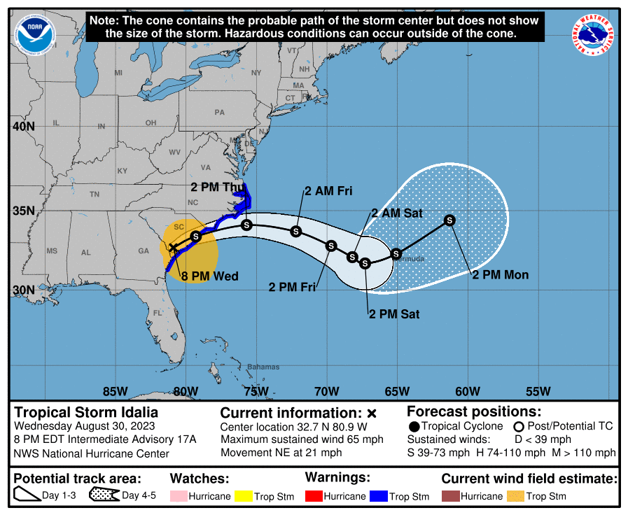
Hurricane Idalia (pronounced ee-DAL-ya), continued its predicted northerly track through the eastern Gulf of Mexico and made landfall as a low end Category 4 hurricane at Keaton Beach, just south of Perry in Taylor County around 0745 EDT this morning. After making landfall in Taylor County, Idalia crossed into southeastern Georgia as a Category 1 hurricane around 1100 EDT this morning, and then crossed in South Carolina as a Tropical Storm early this evening. Currently Idalia is located 60 miles west of Charleston, South Carolina and will emerge into the Atlantic Ocean just off the North Carolina coast tomorrow morning.
COASTAL WATCHES/WARNINGS AND FORECAST CONE FOR STORM CENTER
SUMMARY OF 2000 EST…0000 UTC…INFORMATION
——————————————————————————-
LOCATION…32.7N 80.9W
ABOUT 60 MI…95 KM W OF CHARLESTON SOUTH CAROLINA
MAXIMUM SUSTAINED WINDS…65 MPH…100 KM/H
PRESENT MOVEMENT…NE OR 35 DEGREES AT 21 MPH…33 KM/H
MINIMUM CENTRAL PRESSURE…985 MB…29.09 INCHES
SUMMARY OF WATCHES AND WARNINGS IN EFFECT:
A Storm Surge Warning is in effect for…
* St. Catherine’s Sound Georgia to South Santee River South Carolina
A Tropical Storm Warning is in effect for…
* Altamaha Sound, Georgia northward to the North Carolina/Virginia border
* Pamlico and Albemarle Sounds
A Storm Surge Watch is in effect for…
* Beaufort Inlet to Ocracoke Inlet North Carolina
* Neuse and Pamlico Rivers North Carolina
A Storm Surge Warning means there is a danger of life-threatening inundation, from rising water moving inland from the coastline in the indicated locations. For a depiction of areas at risk, please see the National Weather Service Storm Surge Watch/Warning Graphic, available at https://hurricanes.gov. This is a life-threatening situation. Persons located within these areas should take all necessary actions to protect life and property from rising water and the potential for other dangerous conditions. Promptly follow evacuation and other instructions from local officials.
A Tropical Storm Warning means that tropical storm conditions are expected somewhere within the warning area.
A Storm Surge Watch means there is a possibility of life-threatening inundation, from rising water moving inland from the coastline in the indicated locations. For a depiction of areas at risk, please see the National Weather Service Storm Surge Watch/Warning Graphic, available at https://hurricanes.gov.
FORECAST DISCUSSION:
The following excerpt is from the Forecast Discussion issued at 1700 EDT today:
“Idalia’s radar and satellite presentation has become increasingly asymmetric. A coastal front appears to have developed just inland of the coasts of Georgia and South Carolina, with heavy rainfall being enhanced along and to the northwest of this boundary. The highest WSR-88D velocities observed are about 60-65 kt at an elevation of 5000 feet, indicating that Idalia is no longer a hurricane. The advisory intensity is set at 60 kt, which is probably a bit generous.
The initial motion is now northeastward, or 035/18 kt, with Idalia moving between the northwestern periphery of a mid-level ridge located over the Greater Antilles and a deep-layer trough moving across the northeastern U.S. The storm is expected to turn toward the east and east-southeast during the next 48 hours, but then slow down considerably as the trough lifts out and leaves Idalia behind. There is fairly high confidence that Idalia will move slowly eastward over the western Atlantic, in the vicinity of Bermuda, during the latter part of the forecast period, although there is less confidence in the details of that motion due to large model spread.
Additional weakening is expected while Idalia’s center continues moving over land through tonight. However, once the center moves back offshore on Thursday, model fields suggest that Idalia could interact with the aforementioned coastal front, with an area of stronger winds developing along the boundary near eastern North Carolina during the day. Based on this scenario, the NHC intensity forecast closely follows the GFS solution at 24 and 36 hours. After 36 hours, there is more uncertainty on Idalia’s intensity and structure. Some guidance suggests that Idalia will continue interacting with the front and possibly become post-tropical, particularly if it struggles to maintain organized deep convection. For now, the NHC forecast keeps Idalia as a tropical storm for the entire forecast period.”
SITUATION AND ACTIONS:
As of 1700 EDT, all tropical storm and hurricane watches and warnings had been discontinued except for a Tropical Storm Warning for the east coast from Flager County and northwards. At 2000, the last Tropical Storm warning for the east coast of Florida was dropped. The only warning still in effect were Flood Warnings in effect for flooding near some rivers in Desoto and Manatee Counties.
The ARES Groups that were activated for service during Hurricane Idalia have now begun to demobilize or have completed demobilization.
All ARES, ACS, and CERT personnel are encouraged to continue to check each advisory issued by the National Hurricane Center in Miami on Tropical Depression Ten and the Tropical Weather Outlook issued four times daily by the National Hurricane Center.
LATEST NATIONAL HURRICANE CENTER INFORMATION:
Public Advisories: https://www.nhc.noaa.gov/text/refresh/MIATCPAT2+shtml/072333.shtml?
Forecast Advisory: https://www.nhc.noaa.gov/text/refresh/MIATCMAT2+shtml/072100.shtml?
Forecast Discussion: https://www.nhc.noaa.gov/text/refresh/MIATCDAT2+shtml/072057.shtml?
Latest GOES Satellite Floater Images and Loop: https://www.star.nesdis.noaa.gov/GOES/floater.php?stormid=AL172022#navLink.
CONCLUSION
The ARRL West Central Florida Section extends its sincere thanks for the service of all ARES members, ACS members, and CERT team members who provided service during Hurricane Idalia
This will be the last bulletin issued for Tropical Storm Idalia.