WCF SECTION SPECIAL BULLETIN #23-01 – 2100 EST – 08/26/23
TROPICAL DEPRESSION TEN – 2100 EST – 8/26/23
Since last weekend, there has been an area of disturbed weather that at first was on the south side of Central America. That area of disturbed weather, became Invest 93L, earlier this week. This afternoon Invest 93L, which has been moving slowly in a northerly direction, acquired full tropical characteristics. At 1700 EDT, the National Hurricane Center, began to issue advisories on Tropical Depression Ten. When Tropical Depression Ten, reached Tropical Storm strength, it will be named Idalia (pronounced ee-DAL-ya). For a full pronounciation guide of the names for 2023 go to: https://www.nhc.noaa.gov/pdf/aboutnames_pronounce_atlc.pdf. With the threat to the State of Florida and the ARRL West Central Florida Section, we are now initiating WCF SECTION SPECIAL BULLETINS on Tropical Depression Ten.
COASTAL WATCHES/WARNINGS AND FORECAST CONE FOR STORM CENTER
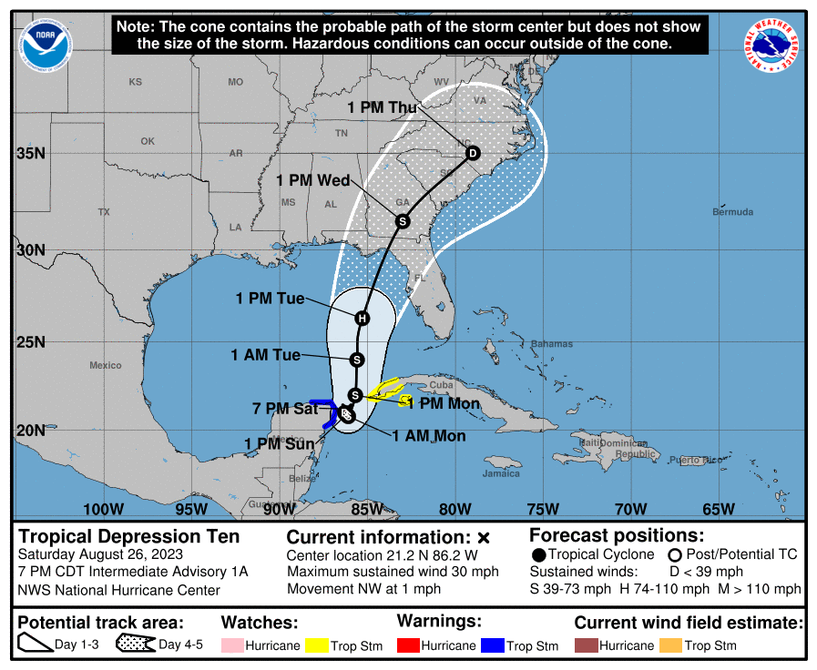
SUMMARY OF 2000 EST…0000 UTC…INFORMATION
——————————————————————————-
LOCATION…21.2N 86.2W
ABOUT 45 MI…70 KM ENE OF COZUMEL MEXICO
MAXIMUM SUSTAINED WINDS…30 MPH…45 KM/H
PRESENT MOVEMENT…NW OR 315 DEGREES AT 1 MPH…2 KM/H
MINIMUM CENTRAL PRESSURE…1005 MB…29.68 INCHES
SUMMARY OF WATCHES AND WARNINGS IN EFFECT:
A Tropical Storm Warning is in effect for…
* Yucatan Peninsula from Tulum to Rio Lagartos, including Cozumel
A Tropical Storm Watch is in effect for…
* Pinar del Rio and the Isle of Youth
A Tropical Storm Warning means that tropical storm conditions are expected somewhere within the warning area within 36 hours.
A Tropical Storm Watch means that tropical storm conditions are possible within the watch area, generally within 48 hours.
At the present time there are no tropical storm watches or warnings in effects for the ARRL West Central Florida Section or the State of Florida. This is likely to change as next week progresses.
FORECAST DISCUSSION:
The following excerpt is from the Forecast Discussion issued at 1700 EDT today:
“The cloud pattern of the low pressure area located near the northeastern Yucatan Peninsula of Mexico has gradually become better organized today. Radar observations show a circulation has developed, although surface observations indicate that the western semicircle of this circulation is rather weak at this time. Given the increased organization, advisories are being initiated on Tropical Depression Ten. Surface synoptic observations suggest that the current intensity is around 25 kt.
The current motion estimate is nearly stationary. There is a weakness in the subtropical ridge to the north of the tropical cyclone, leaving the system in a region of very weak steering flow. The dynamical guidance indicates that the system will remain in weak steering currents for the next 24 to 36 hours, so very little motion is predicted during that period. After that time, a mid-level ridge begins to build to the east of the tropical cyclone. This should cause a generally northward motion in the next 2 to 3 days. Then, a gradual turn to the north-northeast is expected as the system moves along the northwestern periphery of the ridge. The official track forecast is a blend of the simple and corrected dynamical model consensus guidance.
The tropical cyclone will be moving over very warm waters with only moderate vertical wind shear anticipated during the next several days. Therefore, gradual strengthening is forecast. The official forecast is similar to the latest LGEM guidance and shows the system becoming a hurricane over the eastern Gulf of Mexico. Users are reminded that there is significant uncertainty in 3-4 day intensity predictions and are urged to monitor changes to future forecasts.”
SITUATION AND ACTIONS:
All ARES groups in the ARRL West Central Florida Section are monitoring their situations carefully in case they are requested to activate. Several counties have already brought their emergency perations centers up to a partial activation status, which for the most part is monitoring the situation. Today, Florida Governor Ron Desantis signed Executive Order 23-171, declaring a state of emergency for 33 Florida counties, which include all the counties of the ARRL West Central Florida Section. To read Executive Order 23-171 go to https://www.flgov.com/wp-content/uploads/2023/08/EO-23-171.pdf
All ARES, ACS, and CERT personnel are encouraged to rush to completion any preparation activities in the next 24 hours. All ARES, ACS, and CERT personnel are encouraged to continue to check each advisory issued by the National Hurricane Center in Miami on Tropical Depression Ten and the Tropical Weather Outlook issued four times daily by the National Hurricane Center.
LATEST NATIONAL HURRICANE CENTER INFORMATION:
Public Advisories: https://www.nhc.noaa.gov/text/refresh/MIATCPAT2+shtml/072333.shtml?
Forecast Advisory: https://www.nhc.noaa.gov/text/refresh/MIATCMAT2+shtml/072100.shtml?
Forecast Discussion: https://www.nhc.noaa.gov/text/refresh/MIATCDAT2+shtml/072057.shtml?
Latest GOES Satellite Floater Images and Loop: https://www.star.nesdis.noaa.gov/GOES/floater.php?stormid=AL172022#navLink.
CONCLUSION
The next WCF SECTION SPECIAL BULLETIN will be issued tomorrow following the 1700 EDT advisory on Tropical Storm Ten, unless conditions warrant a sooner bulletin release.