WCF SECTION SPECIAL BULLETIN #22-16 – 2100 EDT – 9/29/22
HURRICANE IAN – 2100 EDT – 9/29/22
Hurricane Ian, which was a Category 4 at landfall yesterday, crossed the State of Florida and exited the Florida east coast earlier this afternoon as a Tropical Storm. Ian is now off of the Florida east coast, east of St. Augustine, and has re-intensified to a Category 1 hurricane. Ian is headed for a second landfall in the United States just north of Charleston, South Carolina, and move inland and travel just east of Rock Hill, SC and Charlotte, NC as a Tropical Storm.
Conditions over the ARRL West Central Florida Section will continue to improve tonight and tomorrow. Now over two million people in the State of Florida are without electrical power and many have damage to their homes. So if you are in the dark tonight and or have damage to your home, you are not alone. Help your friends and neighbors if you are able to do so.
COASTAL WATCHES/WARNINGS AND FORECAST CONE FOR STORM CENTER
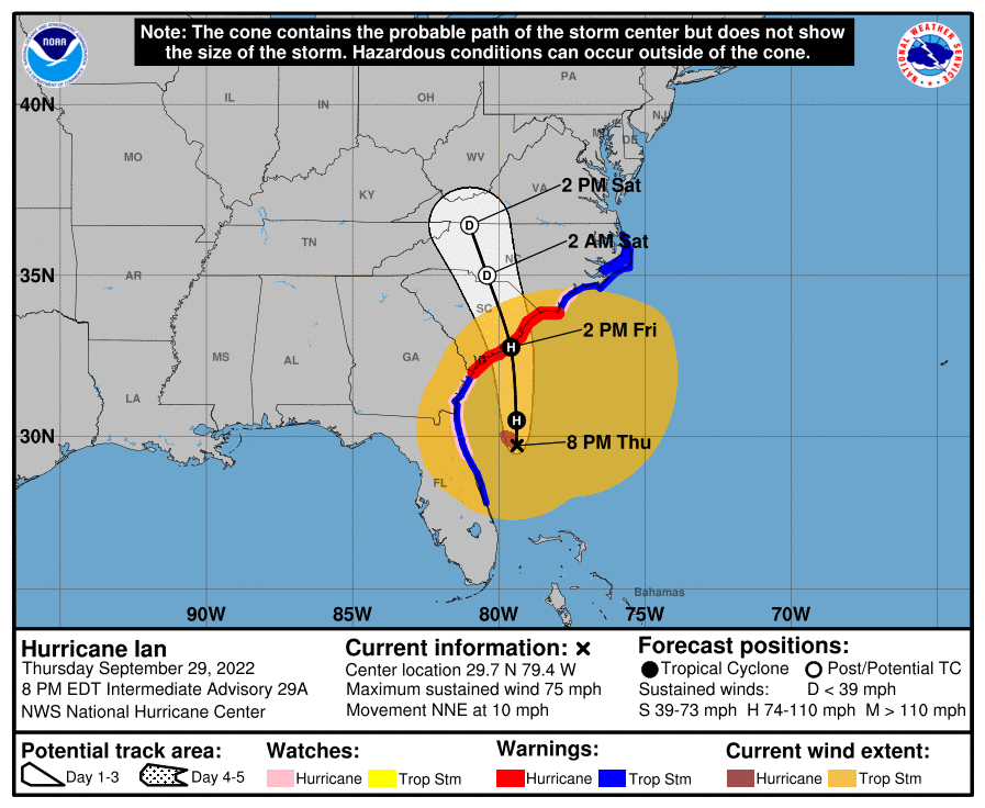
SUMMARY OF 0500 PM EDT…2100 UTC…INFORMATION
———————————————-
LOCATION…29.7N 79.4W
ABOUT 215 MI…350 KM S OF CHARLESTON SOUTH CAROLINA
ABOUT 300 MI…485 KM SSW OF CAPE FEAR NORTH CAROLINA
MAXIMUM SUSTAINED WINDS…75 MPH…120 KM/H
PRESENT MOVEMENT…NNE OR 30 DEGREES AT 10 MPH…17 KM/H
MINIMUM CENTRAL PRESSURE…986 MB…29.12 INCHES
SUMMARY OF WATCHES AND WARNINGS IN EFFECT:
A Storm Surge Warning is in effect for…
* Flagler/Volusia Line to Cape Fear
* Neuse River
* St. Johns River
A Hurricane Warning is in effect for…
* Savannah River to Cape Fear
A Tropical Storm Warning is in effect for…
* Sebastian Inlet to Savannah River
* Cape Fear to Duck North Carolina
* Pamlico Sound
A Storm Surge Watch is in effect for…
* North of Cape Fear to Duck North Carolina
* Pamlico River
* Cape Fear River
A Hurricane Watch is in effect for…
* Flagler/Volusia County Line to the Savannah River
* East of Cape Fear to Surf City
FORECAST DISCUSSION:
The following excerpt is from the Forecast Discussion issued at 1700 EDT today:
“Ian remains a hybrid tropical cyclone with characteristics of an extratropical low, including a comma-pattern on satellite images and some frontal features in the outer circulation. The cyclone continues to have a warm core, however, and all indications are that it will re-develop strong convection over the center overnight. Based on Melbourne Doppler radar velocity data of persistent 70-80-kt winds from 5-10 thousand feet, and earlier sustained winds of about 60 kt near that band from an observation in New Smyrna Beach, the initial wind speed is raised to 65 kt. This makes Ian a hurricane again. An Air Force Reserve Hurricane Hunter aircraft is scheduled to fly through Ian this evening and will provide a
better intensity estimate.
Ian finally appears to be making more of a turn to the north-northeast this afternoon. The hurricane should turn to the north overnight due to the incoming trough diving southward over the southern United States and then north-northwestward on Saturday with an increase in forward speed. While the overall synoptic pattern is similar in all of the models, Ian has been uncooperative and remains right of the previous track. Thus, the new forecast is adjusted to the east, and lies east of the model consensus. Assuming Ian re-develops thunderstorms near the core overnight, it should take the expected north-northwest turn, but this shouldn’t be considered a confident forecast yet. Because of the
uncertainty, the Hurricane Warning has been extended eastward into North Carolina to Cape Fear.
The hurricane is moving over the Gulf Stream for the next day or so, where it has some time for further re-intensification. Additionally, the trough interaction should provide a baroclinic energy kick. These factors point to some strengthening before landfall tomorrow. The new forecast is close to the GFS and regional hurricane models and is a bit stronger than before. It should be emphasized that while we don’t expect Ian to be a classic
hurricane at landfall, this does not diminish the danger it poses. Strong winds and storm surge will also extend far from the center and will begin well before the center arrives.”
SITUATION AND ACTIONS:
As of 1700 EDT today, all of the Tropical Storm and Hurricane Watches and Warnings were discontinued earlier today. The only watches or warnings still in effect are:
- Rip Current Statement: Coastal Pasco, Pinellas, Hillsborough, Manatee, Sarasota, and Charlotte Counties
- Flood Warnings: Peace River in Polk, Hardee, Desota, and Charlotte Counties.
The ARRL West Central Florida Section ARES remains at a Level 1 alert until more ARES groups. Pasco County ARES and Manatee County ARES demobilized earlier today. As far as we know, all other ARES groups are still partially or fully mobilized.
Note: The Section ARES Alert Level simply reflects the activation status of local ARES groups in the ARRL West Central Florida Section. Each ARES groups activates at the request of their served agencies and or in accordance with their local ARES plan.
Section ARES Alert Levels:
Level 3: One or more ARES groups on Standby for possible activation in one or more WCF Counties.
Level 2: One or more WCF Section ARES Groups are activated.
Level 1: All WCF Section ARES Groups are activated.
All ARES, ACS, and CERT personnel are encouraged to continue to check each advisory issued by the National Hurricane Center in Miami and the Tropical Weather Outlook issued four times daily by the National Hurricane Center.
Arc Thames W4CPD, Section Emergency Coordinator – Northern Florida Section, has been designated as the liaison between Florida Tri-Section ARES and the Florida Division of Emergency Management. The following webpage has information on a couple of upcoming opportunities to volunteer and qualifications to volunteer: http://arrlwcf.org/wcf-section-programs/ares/hurricane-ian-service-requests/. Any volunteer assignment that become available will be in the recovery phase. Please, DO NOT SELF ACTIVATE. Any such volunteers will be contacted and authorized if they are to proceed.
The Florida Tri-Section ARES Net will continue to operate for the duration on approximately the following schedule:
- 0800-2000 EDT 7.247 MHz or 7.247 MHz
- 2000-0800 EDT 3.940 MHz or 3.950 MHz
The Hurricane Watch Net is continuing operations for Hurricane Ian on 14.325 MHz and on 7.268 MHz. The following net schedule was obtained from the Hurricane Watch Net website that goes into full effect for the duration of Hurricane Ian.
- Resume operations Tuesday morning on 14.325.00 MHz at 8:00 AM EDT (1200 UTC). Remain active until we lose propagation.
- Activate our 40-meter Net on 7.268.00 MHz at 7:00 PM EDT (2300 UTC). Remain active until midnight eastern.
LATEST NATIONAL HURRICANE CENTER INFORMATION:
Public Advisories: https://www.nhc.noaa.gov/text/refresh/MIATCMAT4+shtml/232103.shtml?
Forecast Advisory: https://www.nhc.noaa.gov/text/refresh/MIATCMAT4+shtml/232103.shtml?
Forecast Discussion: https://www.nhc.noaa.gov/text/refresh/MIATCDAT4+shtml/232054.shtml?
Latest GOES Satellite Floater Images and Loop: https://www.star.nesdis.noaa.gov/GOES/floater.php?stormid=AL092022#navLink
CONCLUSION
This will be the last special bulletin for Hurricane Ian, unless it somehow threatens the ARRL West Central Florida Section, which is very unlikely.