WCF SECTION SPECIAL BULLETIN #22-14 – 1900 EDT – 9/28/22
HURRICANE IAN – 1900 EDT – 9/28/22
Hurricane Ian is now Category 3, made landfall around 1505 EDT this afternoon at Cayo Costa Island in Charlotte Harbor. The eye of Ian is now moving inland up through Charlotte County and approaching the Desoto County line. The eye of Ian is expected to move through Desoto and Hardee through this evening and through Polk County in the early morning hours of 9/29/22. Conditions will slowly begin to improve late tomorrow and on Friday. By now over a million people in West Central Florida are without power and by the time this bulletin is issued, that number could have risen significantly.
COASTAL WATCHES/WARNINGS AND FORECAST CONE FOR STORM CENTER
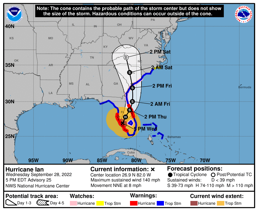
SUMMARY OF 0500 PM EDT…2100 UTC…INFORMATION
———————————————-
LOCATION…26.9N 82.0W
ABOUT 5 MI…10 KM E OF PUNTA GORDA FLORIDA
ABOUT 120 MI…190 KM SSW OF ORLANDO FLORIDA
MAXIMUM SUSTAINED WINDS…140 MPH…220 KM/H
PRESENT MOVEMENT…NNE OR 20 DEGREES AT 8 MPH…13 KM/H
MINIMUM CENTRAL PRESSURE…945 MB…27.91 INCHES
SUMMARY OF WATCHES AND WARNINGS IN EFFECT:
A HURRICANE WARNING IS IN EFFECT FOR…
* CHOKOLOSKEE TO ANCLOTE RIVER…INCLUDING TAMPA BAY
* SEBASTIAN INLET TO FLAGLER/VOLUSIA COUNTY LINE
A STORM SURGE WARNING IS IN EFFECT FOR…
* SUWANNEE RIVER SOUTHWARD TO FLAMINGO
* TAMPA BAY
* FLAGLER/VOLUSIA LINE TO THE MOUTH OF THE SOUTH SANTEE RIVER
* ST. JOHNS RIVER
A TROPICAL STORM WARNING IS IN EFFECT FOR…
* INDIAN PASS TO THE ANCLOTE RIVER
* FLAMINGO TO SEBASTIAN INLET
* FLAGLER/VOLUSIA COUNTY LINE TO SURF CITY
* FLAMINGO TO CHOKOLOSKEE
* LAKE OKEECHOBEE
* BIMINI AND GRAND BAHAMA ISLANDS
A STORM SURGE WATCH IS IN EFFECT FOR…
* NORTH OF SOUTH SANTEE RIVER TO LITTLE RIVER INLET
* FLORIDA BAY
A HURRICANE WATCH IS IN EFFECT FOR…
* FLAGLER/VOLUSIA COUNTY LINE TO THE SOUTH SANTEE RIVER
* LAKE OKEECHOBEE
A TROPICAL STORM WATCH IS IN EFFECT FOR…
* NORTH OF SURF CITY TO CAPE LOOKOUT
FORECAST DISCUSSION:
The following excerpt is from the Forecast Discussion issued at 1700 EDT today:
“An Air Force Reserve Hurricane Hunter aircraft provided the last fix on Ian just before the hurricane made landfall at Cayo Costa, Florida, with the landfall time near at 305 pm EDT. The minimum pressure had risen to about 940 mb at landfall, suggesting that the winds had come down slightly, and the landfall intensity was estimated near 130 kt. While there hasn’t been much in situ data recently, satellite images show that the eye has become more cloud filled, and Tampa Doppler radar data is indicating a gradual reduction in winds. The initial intensity is set to 120 kt on this advisory.
Further weakening is forecast while Ian moves over central Florida during the next day and emerges into the western Atlantic later on Thursday. While there is a lot of vertical wind shear in the environment there, a favorable trough interaction from a trough in the southern United States is expected to counteract the shear, resulting in Ian staying a strong tropical storm through landfall on the southeast U.S. coast. Little change was made to the intensity forecast, which is near or somewhat above the consensus guidance.
The hurricane is moving to the north-northeast at about 8 kt. The aforementioned trough is likely to cause Ian to turn northward over the western Atlantic and to the north-northwest by the weekend. Model guidance is just a bit faster to the north-northeast than the last cycle, and the new forecast is nudged in that direction. The trough will probably cause Ian to transition to an extratropical cyclone in a few days over the southeastern United States, and this new forecast reflects this likelihood.”
SITUATION AND ACTIONS:
As of 1700 EDT today, all of the ARRL West Central Florida Section is still under a Hurricane Warning, with the exception of Pasco County, which is under a Tropical Storm Warning. The following tropical watches and warnings weaare in effect for the ARRL West Central Florida Section:
- Tropical Storm Warning: Pasco County.
- Hurricane Warning: Pinellas, Hillsborough, Manatee, Sarasota, Charlotte Counties on the coast and Polk, Hardee, Highlands, and Desoto Counties in the interior. Counties.
- Storm Surge Warning: Pasco, Pinellas, Hillsborough, Manatee, Sarasota, and Charlotte Counties.
The ARRL West Central Florida Section ARES remains at a Level 1 alert, as all ARES groups in the Section have been activated as of 1100 EDT. This is the first time that a Section ARES Level 1 alert has been issued since Hurricane Irma in 2017.
Note: The Section ARES Alert Level simply reflects the activation status of local ARES groups in the ARRL West Central Florida Section. Each ARES groups activates at the request of their served agencies and or in accordance with their local ARES plan.
Section ARES Alert Levels:
Level 3: One or more ARES groups on Standby for possible activation in one or more WCF Counties.
Level 2: One or more WCF Section ARES Groups are activated.
Level 1: All WCF Section ARES Groups are activated.
All ARES, ACS, and CERT personnel are encouraged to continue to check each advisory issued by the National Hurricane Center in Miami and the Tropical Weather Outlook issued four times daily by the National Hurricane Center. All ARES, ACS, and CERT personnel should be in a secure location and not attempt any kind of travel until conditions improve.
Arc Thames W4CPD, Section Emergency Coordinator – Northern Florida Section, has been designated as the liaison between Florida Tri-Section ARES and the Florida Division of Emergency Management. The following webpage has information on a couple of upcoming opportunities to volunteer and qualifications to volunteer: http://arrlwcf.org/wcf-section-programs/ares/hurricane-ian-service-requests/. Any volunteer assignment that become available will be in the recovery phase. Please, DO NOT SELF ACTIVATE. Any such volunteers will be contacted and authorized if they are to proceed.
The Florida Tri-Section ARES Net will continue to operate for the duration on approximately the following schedule:
- 0800-2000 EDT 7.247 MHz or 7.247 MHz
- 2000-0800 EDT 3.940 MHz or 3.950 MHz
The Hurricane Watch Net is continuing operations for Hurricane Ian on 14.325 MHz and on 7.268 MHz. The following net schedule was obtained from the Hurricane Watch Net website that goes into full effect for the duration of Hurricane Ian.
- Resume operations Tuesday morning on 14.325.00 MHz at 8:00 AM EDT (1200 UTC). Remain active until we lose propagation.
- Activate our 40-meter Net on 7.268.00 MHz at 7:00 PM EDT (2300 UTC). Remain active until midnight eastern.
LATEST NATIONAL HURRICANE CENTER INFORMATION:
Public Advisories: https://www.nhc.noaa.gov/text/refresh/MIATCMAT4+shtml/232103.shtml?
Forecast Advisory: https://www.nhc.noaa.gov/text/refresh/MIATCMAT4+shtml/232103.shtml?
Forecast Discussion: https://www.nhc.noaa.gov/text/refresh/MIATCDAT4+shtml/232054.shtml?
Latest GOES Satellite Floater Images and Loop: https://www.star.nesdis.noaa.gov/GOES/floater.php?stormid=AL092022#navLink
CONCLUSION
The next WCF SECTION SPECIAL BULLETIN for Tropical Storm Ian will be issued tomorrow following the 1700 EDT advisory, unless conditions warrant a sooner bulletin.