WCF SECTION SPECIAL BULLETIN #20-08 – 1800 EDT – 8/24/20
TROPICAL STORM LAURA AND TROPICAL STORM MARCO – 1800 EDT – 8/24/20
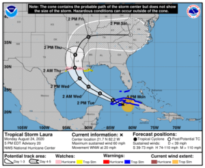
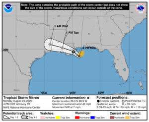
This bulletin will primarily focus on Tropical Storm Laura, which is still in close proximity to the State of Florida but forecast to impact only the Florida Keys. The information on Tropical Storm Marco is presented for information purposes only.
SUMMARY OF 500 PM EDT…2100 UTC…INFORMATION
LOCATION…21.7N 82.2W
ABOUT 40 MI…65 KM E OF THE ISLE OF YOUTH
ABOUT 175 MI…280 KM E OF THE WESTERN TIP OF CUBA
MAXIMUM SUSTAINED WINDS…60 MPH…95 KM/H
PRESENT MOVEMENT…WNW OR 290 DEGREES AT 20 MPH…31 KM/H
MINIMUM CENTRAL PRESSURE…1001 MB…29.56 INCHES
SUMMARY OF WATCHES AND WARNINGS IN EFFECT:
A Storm Surge Watch is in effect for…
* San Luis Pass Texas to Ocean Springs Mississippi
* Lake Pontchartrain, Lake Maurepas, and Lake Borgne
A Hurricane Watch is in effect for…
* Port Bolivar Texas to west of Morgan City Louisiana
A Tropical Storm Warning is in effect for…
* Cuban provinces of Ciego De Avila, Sancti Spiritus, Villa Clara, Cienfuegos, Matanzas, Mayabeque, La Habana, Artemisa, Pinar del
Rio, and the Isle of Youth
* Florida Keys from Craig Key to Key West
* Dry Tortugas
A Tropical Storm Watch is in effect for…
* South of Port Bolivar to San Luis Pass Texas
* Morgan City Louisiana to the Mouth of the Mississippi River
DISCUSSION
The following is excerpts from the Forecast Discussion at 1700 EDT, “The satellite presentation of the tropical storm has improved
somewhat with deep convection remaining over the center, and an increase in banding over the southeastern portion of the circulation. Earlier aircraft and scatterometer data, however, indicated that there has been little change in strength today, and the initial intensity remains 50 kt. These observations have shown the the stronger winds are located in the convective band well east and southeast of the center, and that the system currently lacks an inner core. This is likely the reason that Laura has not been able to strengthen while it has moved over water today. Theaircraft also reported a fairly stable minimum pressure of 1001-1003 mb during its mission this morning and early afternoon.
The intensity forecast philosophy remains the same as the previous advisory. Once Laura moves over the southeastern Gulf of Mexico tonight, a combination of warm sea surface temperatures and low vertical wind shear should allow for steady strengthening. The latest iterations of the global and regional hurricane models continue to show significant deepening while Laura traverses the Gulf of Mexico, and a period or rapid strengthening is possible once an inner core is able to organize. The statistical guidance is again on the lower side of the intensity forecast envelope while the HWRF and CTCI models bringing Laura to major hurricane strength. The NHC intensity forecast is again between these
solutions and is close to the consensus aids.
The initial motion estimate is 290/16 kt. A deep-layer ridge over the western Atlantic is expected to build westward during the next day or so. By early Wednesday, a mid- to upper-level trough over the south-central United States is forecast to erode the western portion of the ridge, which should cause Laura to turn northwestward and then northward toward the northwestern Gulf coast. After landfall, Laura or its remnants are expected to become embedded in the mid-latitude westerlies and recurve over the eastern U.S.on days 4 and 5.”
SITUATION AND ACTIONS:
At the present time Tropical Storm Warnings are in effect for the Florida Keys from Craig Key to Key West and the Dry Tortugas in the State of Florida as Laura is due to pass close to the Florida Keys on Tuesday before heading in the the central and western Gulf of Mexico away from the State of Florida for eventual landfall most likely on the western coast of Louisiana on Thursday.
As of press time, there are no requests for activation from any of our served agencies in the ten counties of the ARRL West Central Florida Section. Manatee County ARES returned to a no activation status from a Level 3 activation (stand by) due to any requests for assistance not being anticipated for this incident. All ARES, ACS, and CERT personnel should continue to monitor the latest National Hurricane Center advisories on Tropical Storm Laura while the storm is in close proximity to the State of Florida.
LATEST NATIONAL HURRICANE CENTER INFORMATION:
Public Advisories: https://www.nhc.noaa.gov/text/refresh/MIATCPAT3+shtml/222347.shtml
Forecast Advisory: https://www.nhc.noaa.gov/text/refresh/MIATCMAT3+shtml/222051.shtml?
Forecast Discussion: https://www.nhc.noaa.gov/text/refresh/MIATCDAT3+shtml/222052.shtml?
The next WCF SECTION SPECIAL BULLETIN on Tropical Storm Laura will be issued following the 1700 EDT advisory on Tropical Storm Laura unless conditions warrant a sooner release. If the forecast track holds, tomorrow’s bulletin will be the final WCF SECTION PRESS RELEASE on Tropical Storm Laura.
END OF PRESS RELEASE

