WCF SECTION SPECIAL BULLETIN #8 – 1700 – 9/01/19
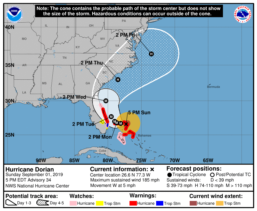 At 1700 EDT (2100 UTC), the distinct eye of Hurricane Dorian was located about 175 miles east of West Palm Beach. Dorian is moving toward the west near 5 mph (7 km/h). A slower westward to west-northwestward motions should continue for the next day or two, followed by a gradual turn toward the northwest. On this track, the core of extremely dangerous Hurricane Dorian will continue to pound Great Abaco this evening and move near or over Grand Bahama Island tonight and Monday. The hurricane will move dangerously close to the Florida east coast late Monday through Tuesday night. Maximum sustained winds are near 185 mph (295 km/h) with higher gusts. Dorian is a category 5 hurricane on the Saffir-Simpson Hurricane Wind Scale. Some fluctuations in intensity are likely, and Dorian is expected to remain a catastrophic hurricane during the next few days. Hurricane-force winds extend outward up to 45 miles (75 km) from the center and tropical-storm-force winds extend outward up to 140 miles (220 km). The last minimum central pressure measured by an Air Force reconnaissance plane a couple of hours ago was 26.88 inches (910 mb).
The following information is from the 1700 EDT Forecast Discussion, “Dorian has slowed down even more and is now moving toward the west or 270 degrees at 4 kt. The steering currents are collapsing and Dorian is expected to slow down a little more, prolonging its catastrophic effects in the northwestern Bahamas. The NHC forecast calls for a slow west to west-northwest motion during the next 48 hours. A turn to the north and northeast with a gradual increase in forward speed is expected thereafter, as the mid-level trough over the eastern United States deepens. The current forecast is not very different from the previous one, and it is very close to the multi-model consensus TVCA. Both the deterministic and consensus tracks have shown the usual variability to the right or to the left from run to run, but the overall trend is for the hurricane to turn northward offshore but dangerously close to the Florida peninsula. Given the uncertainty in the track forecast and the anticipated increase in size of the hurricane, a Hurricane Warning and Storm Surge Warning have been issued for a portion of the Florida east coast. It is once again emphasized that although the official track forecast does not show landfall, users should not focus on the exact track. A small deviation to the left of the track could bring the intense core of the hurricane its dangerous winds closer to or onto the Florida coast.”
Since this time yesterday, due to the approach of Hurricane Dorian, the following watches and warnings have been issued by the National Hurricane Center this morning and added to this afternoon:
A Storm Surge Warning is in effect for…
* Lantana to the Volusia/Brevard County Line (Palm Beach, Martin, St. Lucie, Indian River, and Brevard Counties).
A Storm Surge Watch is in effect for…
* North of Deerfield Beach to Lantana (Broward County).
* Volusia/Brevard County Line to the Flagler/Volusia County Line (Volusia County).
A Hurricane Warning is in effect for…
* Northwestern Bahamas excluding Andros Island
* Jupiter Inlet to the Volusia/Brevard County Line (Martin, St. Lucie, Indian River, and Brevard Counties).
A Hurricane Watch is in effect for…
* Andros Island
* North of Deerfield Beach to Jupiter Inlet (Palm Beach County).
* Volusia/Brevard County Line to the Flagler/Volusia County Line (Volusia County).
A Tropical Storm Warning is in effect for…
* North of Deerfield Beach to Jupiter Inlet (Palm Beach County).
A Tropical Storm Watch is in effect for…
* North of Golden Beach to Deerfield Beach (Broward County).
* Lake Okeechobee.
* Polk County.
* Highlands County.
Late this morning, the three ARRL Florida Section ARES organizations held another conference call to continue coordination of preparedness activities for amateur radio emergency communications. Another conference call is scheduled for tomorrow morning following the 1100 EDT advisory to assess the situation at that point. The online Florida ARES Operator Application is still available if anyone wishes to apply to provide mutual aid outside of their own county, if at a later time that aid may be needed. The form will state the qualifications necessary to apply. The form is Google Docs form and is located at Florida ARES Operator Application. At the present time, applications are limited to amateur radio operators in the State of Florida.
The ARRL West Central Florida Section is at a Level 3 Activation which is a stand by mode. Highlands County Emergency Management is scheduling to open four shelters tomorrow and has requested Highlands County ARES to provide auxiliary communications for those shelters. The ARRL West Central Florida Section will move back to a Level 2 activation, once Highlands County ARES commences operations. Several other county emergency management agencies are closely monitoring and evaluating the situation to see if they will have to commence opening hurricane shelters either for their own population or for evacuees from the Florida east coast. Tomorrow afternoon, per the request of the State EOC, a HF net will be activated on 3950 KHz or 7242 KHz (depending upon band conditions) to coordinate the communications response. Also the State EOC requested a net to be activated on the statewide SARNET repeater system. Ben Henley KI4IGX, our Section Emergency Coordinator, and his staff are continuing to closely monitor the situation and are staying in communications with our local ARES Emergency Coordinators and the State EOC. Our ARES Emergency Coordinators are staying in close communications with their respective Emergency Management offices.
All ARES, ACS, and CERT groups personnel are requested to continue to closely monitor the latest advisories by the National Hurricane Center in Miami. All ARES, ACS, and CERT groups should continue to stay in communication with their respective leadership for their groups in case that group is requested to activate. All ARES, ACS, and CERT groups personnel are highly encouraged to do any final checks on your equipment and supplies in case your group is requested to activate. Also everyone is highly encourage to bring to completion any preparedness activities on your personal property as soon as possible. As we have seen, the risk to the ARRL West Central Florida Section may be reduced, at the moment, but it is by no means past and can change at any time.
The next WCF Section Special Bulletin will be issued following the 1100 advisory tomorrow unless conditions warrant a bulletin to be issued sooner.