WCF SECTION SPECIAL BULLETIN #5 – 1100 – 8/30/19
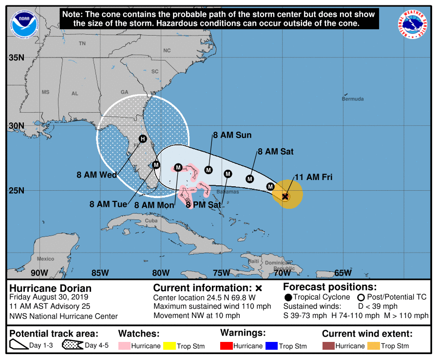
At 1100 EDT (1500 UTC), the eye of Hurricane Dorian was located about 660 east of West Palm Beach. Dorian is moving toward the northwest near 10 mph (17 km/h). A slower west-northwestward to westward motion should begin tonight and continue
into early next week. On this track, the core of Dorian should move over the Atlantic well north of the southeastern and central Bahamas today and tomorrow, be near or over the northwestern
Bahamas on Sunday, and be near the Florida peninsula late Monday.
Maximum sustained winds are near 110 mph (175 km/h) with higher gusts. Dorian is expected to become a major hurricane later today, and it will remain an extremely dangerous major hurricane while it moves near the northwestern Bahamas and approaches the Florida peninsula into early next week. Hurricane-force winds extend outward up to 25 miles (35 km) from the center and tropical-storm-force winds extend outward up to 105 miles (165 km). The estimated minimum central pressure from the NOAA and Air Force reconnaissance planes is 972 mb (28.71 inches).
The following is noteworthy from the 1100 EDT Forecast Discussion issued by the National Hurricane Center, “As the upper-low over Cuba moves westward and a strong subtropical ridge builds over the
western Atlantic as indicated by global models, the hurricane should be forced to turn west-northwestward and westward on a track toward the northwestern Bahamas and the Florida peninsula. By the end of the forecast period, the ridge is forecast to erode and the steering currents will weaken, resulting in Dorian slowing down considerably near and over the Florida peninsula. This increases
the uncertainty in the track forecast during the 4- to -5 day period, and also will lead to a prolonged duration of wind, storm surge, and rainfall. The official forecast has been very consistent so far, and this one is very similar to the previous NHC forecast. It follows the multi-model and corrected consensus,
and is in the middle of the guidance envelope.”
Yesterday, Governor DeSantis issued Executive Order 19-190, expanding the state of emergency to include all 67 counties in Florida. This provides state and local governments ample time, resources and flexibility to prepare as the exact landfall location of Hurricane Dorian continues to fluctuate. Today, Governor Ron DeSantis sent a letter to President Donald Trump formally requesting that he declare a pre-landfall disaster as Florida prepares for Hurricane Dorian. Current forecasts project Hurricane Dorian will hit the East Coast of Florida as a major hurricane, possibly as strong as a Category 4. The Pre-Landfall Declaration request is for all 67 counties in Florida.
Yesterday evening, the three ARRL Florida Section ARES organizations held a conference call to begin coordination of preparedness activities for amateur radio emergency communications. As agreed to on the conference call their was established an online Florida ARES Operator Application. The Florida ARRL sections of Northern Florida, Southern Florida and West Central Florida are now requesting operator assistance for Hurricane Dorian. To qualify you must have completed IS-100, IS-200, IS-700 and IS-800 and have completed a background check. You must be able to be 100% self-sufficient. You must have to bring your food, water, equipment, clothing, tools, tent, sleeping bag, and any other personal items and their is an equipment requirement list on the application as well. The form is Google Docs form and is located at Florida ARES Operator Application. At the present time, applications are limited to amateur radio operators in the State of Florida.
Also the ARRL West Central Florida Section is going to a Level 2 Activation which is a partial activation, due to the activation of ARES operators for Hillsborough County ARES/RACES. Ben Henley KI4IGX, and his staff are continuing to closely monitoring the situation and are staying in communications with our local ARES Emergency Coordinators and the State EOC. Our ARES Emergency Coordinators are staying in close communications with their respective Emergency Management offices.
All ARES, ACS, and CERT groups personnel are requested to continue to closely monitor the latest advisories by the National Hurricane Center in Miami. All ARES, ACS, and CERT groups should stay in communication with their respective leadership for their groups in case that group is requested to activate. All ARES, ACS, and CERT groups personnel are highly encouraged to do any final checks on your equipment and supplies in case your group is requested to activate. Also everyone is highly encourage to continue any preparedness activities on your personal property as soon as possible.
The next WCF Section Special Bulletin will be issued following the 1100 advisory tomorrow unless conditions warrant a bulletin to be issued sooner.