WCF SECTION SPECIAL BULLETIN #4 – 1100 – 8/29/19
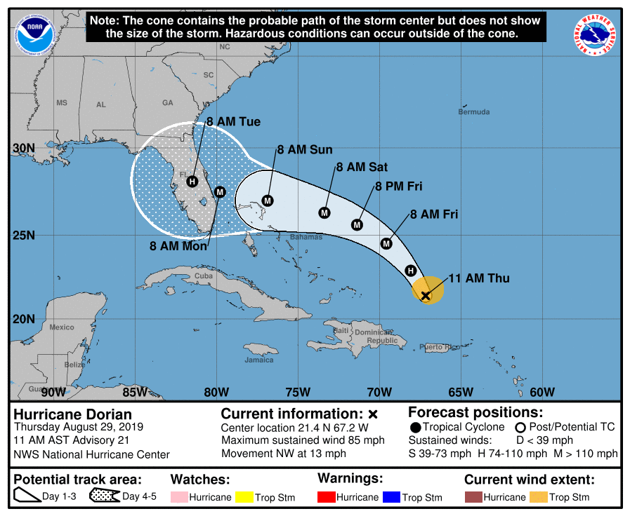
At 1100 EDT (1500 UTC), the center of Hurricane Dorian was located about 220 miles north-northwest of San Juan, Puerto Rico. Dorian is moving toward the northwest near 13 mph (20 km/h), and this general motion is expected to continue through Friday. Maximum sustained winds are near 85 mph (140 km/h) with higher gusts. Strengthening is forecast during the next few days, and Dorian is expected to become a major hurricane on Friday, and remain an extremely dangerous hurricane through the weekend. Hurricane-force winds extend outward up to 15 miles (30 km) from the center and tropical-storm-force winds extend outward up to 90 miles (150 km). The minimum central pressure based on data from a NOAA Hurricane Hunter aircraft is 29.12 inches of mercury or 986 mb.
A west-northwestward motion is forecast to begin by Friday night and continue into the weekend. On this track, Dorian should move over the Atlantic well east of the southeastern and central Bahamas today and on Friday, approach the northwestern Bahamas Saturday, and move near or over portions of the northwest Bahamas on Sunday. The following is noteworthy from the 1100 Forecast Discussion issued by the National Hurricane Center, “The new NHC track forecast is virtually unchanged from the
previous advisory, and lies very close to the multi-model consensus. It should be noted that the ECMWF, UKMET, and HFIP corrected consensus models remain south of the official forecast. The spread of the deterministic models and the various ensemble guidance is still considerable at days 4 and 5, and it is too soon to specify where along the Florida east coast the greatest impacts could
occur.”
Yesterday afternoon at 1400 EDT, Governor Ron DeSantis issued Executive Order Executive Order 19-189, declaring a state of emergency for counties in the path of Hurricane Dorian, which includes Highlands County in the ARRL West Central Florida Section. The Governor is urging all Floridians on the East Coast to prepare for impacts, as the latest forecasts from the National Hurricane Center project Hurricane Dorian will make landfall on Florida’s East Coast as a major hurricane. By declaring a state of emergency, Governor DeSantis is ensuring that state and local governments have ample time, resources and flexibility to prepare. The State Emergency Operations Center went to a Level 2 activation this morning, enhancing the coordination between federal, state and local emergency management agencies. To read more about the State EOC activation status go to https://floridadisaster.org/state-eoc/.
At this time, ARRL West Central Florida Section ARES will go to a Level 3 activation, which is a standby status. Our Section Emergency Coordinator, Ben Henley KI4IGX, and his staff are closely monitoring the situation and are staying in communications with our local ARES Emergency Coordinators and the State EOC. A statewide conference call is planned this evening between all three ARRL Florida Section ARES programs to coordinate operations. At the present time, Hillsborough County ARES/RACES is partially activated and plans to go to a full activation on Friday as their Emergency Management office is planning on opening shelters for evacuees from the Florida east coast. Our ARES Emergency Coordinators are staying in close communications with their respective Emergency Management offices.
All ARES, ACS, and CERT groups personnel are requested to continue to closely monitor the latest advisories by the National Hurricane Center in Miami. All ARES, ACS, and CERT groups should stay in communication with their respective leadership for their groups in case that group is requested to activate. All ARES, ACS, and CERT groups personnel are highly encouraged to do any final checks on your equipment and supplies in case your group is requested to activate. Also everyone is highly encourage to continue any preparedness activities on your personal property as soon as possible.
The next WCF Section Special Bulletin will be issued following the 1100 advisory tomorrow unless conditions warrant a bulletin to be issued sooner.
END OF BULLETIN