WCF SECTION SPECIAL BULLETIN #3 – 1100 – 8/28/19
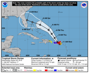
At 1100 hours, the center of Tropical Storm Dorian waslocated about 25 miles southeast of St. Croix, in the U.S. Virgin Islands. Dorian is moving toward the northwest near 13 miles per hour, and this motion is expected to continue for the next day or two. On this track, Dorian should move near the U.S. and British Virgin Islands and then continue over the open Atlantic well east of the southeastern Bahamas. Maximum sustained winds have increased to near 70 miles per hour with higher gusts. Dorian is forecast to become a hurricane later today and continue strengthening during the next few days over the Atlantic waters. Tropical-storm-force winds extend outward up to 80 miles primarily to the east of the center. An Air Force plane just estimated a minimum central pressure of 29.50 inches of mercury. A Hurricane Warning is in effect for, Vieques and Culebra, the U.S. Virgin Islands, and the British Virgin Islands. A Hurricane Watch and a Tropical Storm Warning is in effect for Puerto Rico. A Tropical Storm Watch is in effect for the parts of the Dominican Republic from Isla Saona to Samana. The following is the longer term outlook according to the forecast discussion issued at 1100, “The cyclone is heading toward a weakness in the Atlantic subtropical ridge, and this motion should continue for the next 2 to 3 days. However, after that time, all global models build a robust ridge over the western Atlantic, and this flow pattern should force Dorian to turn more to the west-northwest toward Florida and the southeast coast of the United States. All indications are that by this Labor Day weekend, a powerful hurricane will be near the Florida or southeastern coast of
the United States.”
The State EOC is at a Level 3 Activation, which is a monitoring status. For more information and status reports on activities you may go to https://floridadisaster.org/state-eoc/. Our Section Emergency Coordinator, Ben Henley KI4IGX, and his staff are closely monitoring the situation and are staying in communications with our local ARES Emergency Coordinators. Our ARES Emergency Coordinators are staying in close communications with their respective Emergency Managment offices. At the present time we have still not had any requests to activate any ARES or CERT groups from any of our county emergency management offices or any other served agencies.
All ARES, ACS, and CERT groups personnel are request to continue to closely monitor the latest advisories by the National Hurricane Center in Miami. All ARES, ACS, and CERT groups should stay in communication with their respective leadership for their groups in case that group is requested to activate. All ARES, ACS, and CERT groups personnel are highly encouraged to do any final checks on your equipment and supplies in case your group is requested to activate. Also everyone is highly encourage to continue any preparedness activities on your personal property as soon as possible.
The next WCF Section Special Bulletin will be issued following the 1100 advisory tomorrow unless conditions warrant a bulletin to be issued sooner.