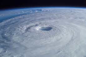
WCF SECTION SPECIAL BULLETIN #7 – 1100 EDT – 9/10/17

SITUATION: As of 1100 EDT, Hurricane Irma was located about 80 miles east south-southeast of Naples and 125 miles south-southeast of Fort Myers. Irma weakened some late yesterday and reintensified slightly and is currently moving north at approximately 9 miles per hour, and has maximum sustained winds of 130 MPH, a Category 3 hurricane. The minimum central pressure is 27.55″. Hurricane Irma finally made the northward turn late last night and early this morning and made its first landfall around 0900 in Cudjoe Key in the Florida Keys.
The forecast track is basically unchanged. Irma is expected to continue its current track to the north as it is going around the western periphery of the mid-Atlantic ridge of high pressure. Hurricane Irma is forecast to make its second landfall in the Fort Myers area in Lee County as a Category 3 or 4 Hurricane and move north along the west coast of the Florida peninsula and going inland for a final time in the big bend area between the Florida peninsula and the Florida peninsula tomorrow morning as a Category 1 Hurricane and moving into southwest Georgia by late afternoon as a Tropical Storm. However, Tropical Storm force winds will impact almost all of the state of Florida. Hurricane force winds will impact the western side of the Florida peninsula and the big bend area.
Hurricane Irma Forecast Discussion: http://www.nhc.noaa.gov/text/refresh/MIATCDAT1+shtml/061448.shtml
Hurricane Irma Graphical Forecast Track: http://www.nhc.noaa.gov/refresh/graphics_at1+shtml/145453.shtml?cone#contents
ACTIONS: At this time, all West Central Florida Section counties have shelters open at this time. All ARES, ACS, and CERT personnel are requested to continue to closely monitor the National Hurricane Center latest advisories on Hurricane Irma. ARES Groups in several WCF Section counties have put in request into State of Florida Constellation system for mutual aid after the passage of Hurricane Irma. Amateur Radio operators are continue to be in communications with their respective team leadership in case their assistance with communications support is needed following the passage of Hurricane Irma. All amateur radio operators and their families should have already completed any preparedness actions and have gone to a shelter, either public if it is not safe to shelter in place. Pay attention to the latest watches and or warnings as issued by the National Weather Service.
A Regional SKYWARN Net is being currently held on the NI4CE Repeater System to take reports of severe weather. The State of Florida SARNet is currently running a coordination and assistance net to help communicate between the county EOC’s and the State EOC and to provide assistance to amateur radio operators in other ways, time permitting.
Right now the priority is tactical shelter communications, EOC Communications, and even SKYWARN Nets as Hurricane Irma approaches. Any health and welfare inquiries should go through the American Red Cross “Safe and Well” website. The link to the ARRL Press Release on this is http://www.arrl.org/news/hurricane-irma-amateur-radio-emergency-and-priority-traffic-is-moving-health-welfare-traffic-queued. Also the ARRL has release a press release concerning frequency usage during the Hurricane Irma response. The link to that ARRL press release is http://www.arrl.org/news/operating-procedures-during-hurricane-irma.
The next WCF SECTION SPECIAL BULLETIN for Hurricane Irma will be issued tomorrow at 1100 EDT, or sooner if conditions warrant.