AN OPEN LETTER FROM OUR NEW SECTION EMERGENCY COORDINATOR

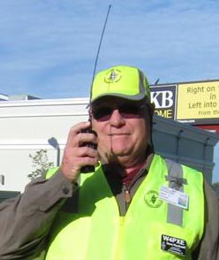
The following is an open letter to all ARES personnel in the ARRL West Central Florida Section, from Dave Rockwell W4PXE, our new Section Emergency Coordinator:
“Greetings to West Central Florida (WCF) Amateur Radio Emergency Services (ARES) Members.
I am Dave Rockwell, W4PXE. Our Section Manager, Mike Douglas, W4MDD, asked me to serve as your new Section Emergency Coordinator (SEC) and lead our section ARES program. I recognize this entails filling some rather big shoes. I am keenly aware that I follow in the footsteps of giants in the field of public service, some who have become silent keys and others whose personal situations led them to step aside. Many of you know me as the Section Traffic Manager and formerly as an Eagle Net Manager. Compared to many, I am relatively new to amateur radio, having been first licensed in 2012. During my 20-year military career as a communications engineer and subsequently as a contractor for over 20 years I have been directly involved with disaster response and contingency planning. I hope to bring this experience to improving our already effective ARES program.
My role as coordinator is simple, ensuring our ARES and Auxiliary Communications Service (ACS) members receive the support they require from the American Radio Relay League (ARRL) and our section leadership. Emergency services start and end at the local level in all incidents. Our ARES members directly support various county, city, tribal, and non-governmental agencies who respond to incidents and events. Our ARES radio operators perform a myriad of duties depending on their individual qualifications and skill sets. We, the ARRL ARES leadership, do not intervene or interject ourselves into the direct support provided to our supported agencies. Each ARES member is encouraged to train continuously, achieve the required qualifications, and mentor new members supporting your responding agency.
There are a few things every ARES member should consider. First, complete the ARRL Emergency Communications training. The league has invested heavily in these training courses. The courses were developed in close coordination and with input from responding agencies including the Federal Emergency Management Agency (FEMA), the Cybersecurity and Infrastructure Security Agency (CISA), and many of our non-governmental partners. Keep in mind, what you learn in the courses is good to know, but it does not supplant the training required by your supported agency.
There is considerable discussion of ARES versus the CISA Auxiliary Communications (AUXCOMM) program. These are by no means mutually exclusive programs. In fact, the ARES and AUXCOMM Position Task Books overlap in many areas and require the same standard of performance. Folks ask me all the time, which program should I participate in? The answer is simple, you should complete the Position Task Books (PTB) that apply for the chair you occupy. For many of our counties, that is the AUXCOMM PTB with additional position-specific PTBs as required by your agencies. Other agencies may require you to complete the Florida Tri-Section ARES Task Book or the ARRL ARES Task Book. There should be absolutely no confusion about which task book you do first! After you meet your initial obligation, I encourage all of you to pursue additional task books as your time and energy permit. The more you know, the more valuable you become.
I encourage all ARES members to pursue emergency management training outside of the communications silo. Some task books require completion of both independent study and classroom Emergency Management Institute (EMI) courses. Do not let those be the only courses you take. While I started in emergency response as a radio operator, I pursued additional opportunities and skills (within the Coast Guard Emergency Management community), and achieved qualification as an Incident Commander, Type 3.
I find that every time I take another EMI-sponsored course, I learn new things and gain broader insight when responding to events. I hope each of you finds the same success and rewards in your studies. I look forward to working with each of you and to all, Happy Holidays, and a Happy New Year.”
END OF PRESS RELEASE


