WCF SECTION SPECIAL BULLETIN #23-02 – 1800 EDT – 8/27/23

TROPICAL STORM IDALIA – 1800 EST – 8/27/23

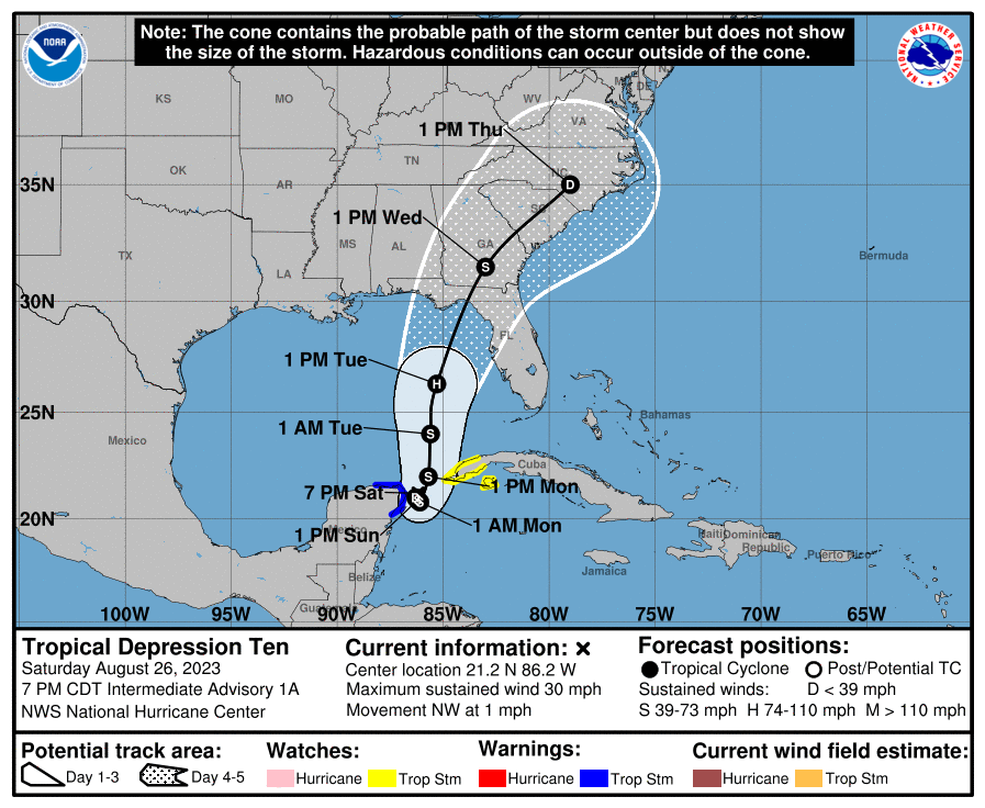
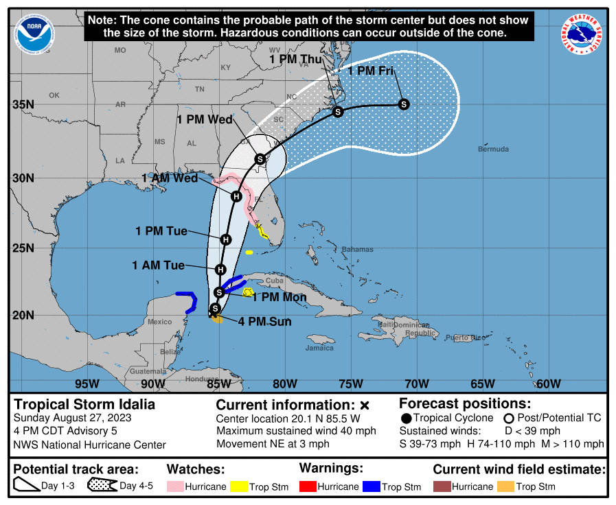
Shortly after the 1100 EDT advisory, Tropical Depression Ten had strengthened enough and was declared Tropical Storm Idalia (pronounced ee-DAL-ya).  The center of Idalia is just east of the Yucatan, due to lack of steering mechanisms at the moment.  When high pressure to the east and a expected upper low form to the west, Idalia will begin to move in a northerly direction towards the northern gulf coast and is still expected to make landfall on late Wednesday or early Thursday in the big bend area of Florida.  Idalia is expected to strengthen into a Category 1 hurricane before landfall.

COASTAL WATCHES/WARNINGS AND FORECAST CONE FOR STORM CENTER

SUMMARY OF 2000 EST…0000 UTC…INFORMATION

——————————————————————————-
LOCATION…20.1N 85.5W
ABOUT 95 MI…155 KM ESE OF COZUMEL MEXICO
MAXIMUM SUSTAINED WINDS…40 MPH…65 KM/H
PRESENT MOVEMENT…NE OR 40 DEGREES AT 3 MPH…6 KM/H
MINIMUM CENTRAL PRESSURE…995 MB…29.39 INCHES

SUMMARY OF WATCHES AND WARNINGS IN EFFECT:

A Storm Surge Watch has been issued for the Gulf coast of Florida
from Chokoloskee to Indian Pass, including Tampa Bay.

A Hurricane Watch has been issued for the Gulf coast of Florida
from Englewood to Indian Pass, including Tampa Bay.

A Tropical Storm Watch has been issued for the Gulf coast of
Florida south of Englewood to Chokoloskee, and for the Dry Tortugas.

SUMMARY OF WATCHES AND WARNINGS IN EFFECT:

A Tropical Storm Warning is in effect for…
* Yucatan Peninsula from Tulum to Rio Lagartos, including Cozumel
* Pinar del Rio Cuba

A Storm Surge Watch is in effect for…
* Chokoloskee to Indian Pass Florida, including Tampa Bay

A Hurricane Watch is in effect for…
* Englewood to Indian Pass Florida, including Tampa Bay

A Tropical Storm Watch is in effect for…
* Isle of Youth Cuba
* South of Englewood to Chokoloskee Florida
* Dry Tortugas Florida

A Storm Surge Watch means there is a possibility of life-threatening inundation, from rising water moving inland from the coastline, in the indicated locations during the next 48 hours.  For a depiction of areas at risk, please see the National Weather Service Storm Surge Watch/Warning Graphic, available at hurricanes.gov.

A Hurricane Watch means that hurricane conditions are possible within the watch area. A watch is typically issued 48 hours before the anticipated first occurrence of tropical-storm-force winds, conditions that make outside preparations difficult or dangerous.

A Tropical Storm Warning means that tropical storm conditions are expected somewhere within the warning area.

A Tropical Storm Watch means that tropical storm conditions are possible within the watch area.

FORECAST DISCUSSION:

The following excerpt is from the Forecast Discussion issued at 1700 EDT today:

“Idalia’s cloud pattern is gradually becoming a little better organized, with a curved convective band forming over the southern semicircle of the circulation. Upper-level outflow is currently restricted over the northern portion of the system, however.  The advisory intensity is held at 35 kt based on a subjective Dvorak estimate from TAFB. Another aircraft reconnaissance mission into the storm is scheduled for tonight.

The tropical cyclone continues to move rather slowly, and the initial motion estimate is 040/3 kt. Idalia should remain in a weak steering pattern through tonight so slow and possibly erratic motion is likely for the next 12 hours. On Monday, a mid-level ridge begins to build to the northeast of the tropical cyclone. This should result in a slightly east of northward motion during the next day or two. When the system moves into the northeast Gulf of Mexico, a mid-level trough developing over the eastern United States will likely cause Idalia to turn northeastward with an increase in forward speed. The new official forecast is again shifted slightly eastward, and is somewhat faster than the previous one. This is a blend of the latest ECMWF and GFS solutions and is also between the simple and corrected dynamical consensus tracks.

The intensity forecast is somewhat challenging. Idalia will be traversing eastern Gulf of Mexico waters of high oceanic heat content, and the environmental air mass should remain fairly moist. The flow to the east of an upper-level trough could impart some
vertical wind shear over the system, but this shear could also be compensated by the conducive effect of upper-level diffluence.  There is considerable spread in the model intensity guidance, ranging from minimal to major hurricane status before landfall on
the northeast Gulf coast. The official intensity forecast is a little higher than the previous one, and remains near the higher  end of the guidance. Given the uncertainties, users should monitor future NHC forecasts for possible changes in the predicted strength of Idalia, and prepare for possible significant impacts within the hurricane and storm surge watch areas.”

SITUATION AND ACTIONS:

As of 1700 EDT, the following watches and or warnings are in effect for the ARRL West Central Florida Section:

  • Tropical Storm Watch:  Charlotte, Desoto, Hardee, and Polk Counties.
  • Hurricane Watch:  Pasco, Pinellas, Hillsborough, Manatee, and Sarasota Counties.
  • Storm Surge Watch:  Coastal portions of Pasco, Pinellas, Hillsborough, Manatee, Sarasota, and Charlotte Counties.

As of press time, Hillsborough County ARES/RACES has been requested to do a partial activation beginning tomorrow morning and may be requested to go to a full activation during the day tomorrow or later, depending upon the final path of Idalia. All other ARES groups in the ARRL West Central Florida Section are monitoring their situations carefully in case they are requested to activate.  Several counties have already brought their emergency operations centers up to a partial activation status, which for the most part is monitoring the situation.

All ARES, ACS, and CERT personnel are encouraged to rush to completion any preparation activities in the next 24 hours.  All ARES, ACS, and CERT personnel are encouraged to continue to check each advisory issued by the National Hurricane Center in Miami on Tropical Depression Ten and the Tropical Weather Outlook issued four times daily by the National Hurricane Center.

LATEST NATIONAL HURRICANE CENTER INFORMATION:

Public Advisories: https://www.nhc.noaa.gov/text/refresh/MIATCPAT2+shtml/072333.shtml?

Forecast Advisory: https://www.nhc.noaa.gov/text/refresh/MIATCMAT2+shtml/072100.shtml?

Forecast Discussion:  https://www.nhc.noaa.gov/text/refresh/MIATCDAT2+shtml/072057.shtml?

Latest GOES Satellite Floater Images and Loop:  https://www.star.nesdis.noaa.gov/GOES/floater.php?stormid=AL172022#navLink.

CONCLUSION

The next WCF SECTION SPECIAL BULLETIN will be issued tomorrow following the 1700 EDT advisory on Tropical Storm Ten, unless conditions warrant a sooner bulletin release.

WCF SECTION SPECIAL BULLETIN #23-01 – 2100 EST – 08/26/23

TROPICAL DEPRESSION TEN – 2100 EST – 8/26/23

Since last weekend, there has been an area of disturbed weather that at first was on the south side of Central America.  That area of disturbed weather, became Invest 93L, earlier this week.  This afternoon Invest 93L, which has been moving slowly in a northerly direction, acquired full tropical characteristics.  At 1700 EDT, the National Hurricane Center, began to issue advisories on Tropical Depression Ten.  When Tropical Depression Ten, reached Tropical Storm strength, it will be named Idalia (pronounced ee-DAL-ya).  For a full pronounciation guide of the names for 2023 go to:  https://www.nhc.noaa.gov/pdf/aboutnames_pronounce_atlc.pdf.  With the threat to the State of Florida and the ARRL West Central Florida Section, we are now initiating WCF SECTION SPECIAL BULLETINS on Tropical Depression Ten.

COASTAL WATCHES/WARNINGS AND FORECAST CONE FOR STORM CENTER

SUMMARY OF 2000 EST…0000 UTC…INFORMATION

——————————————————————————-
LOCATION…21.2N 86.2W
ABOUT 45 MI…70 KM ENE OF COZUMEL MEXICO
MAXIMUM SUSTAINED WINDS…30 MPH…45 KM/H
PRESENT MOVEMENT…NW OR 315 DEGREES AT 1 MPH…2 KM/H
MINIMUM CENTRAL PRESSURE…1005 MB…29.68 INCHES

SUMMARY OF WATCHES AND WARNINGS IN EFFECT:

A Tropical Storm Warning is in effect for…
* Yucatan Peninsula from Tulum to Rio Lagartos, including Cozumel

A Tropical Storm Watch is in effect for…
* Pinar del Rio and the Isle of Youth

A Tropical Storm Warning means that tropical storm conditions are expected somewhere within the warning area within 36 hours.

A Tropical Storm Watch means that tropical storm conditions are possible within the watch area, generally within 48 hours.

At the present time there are no tropical storm watches or warnings in effects for the ARRL West Central Florida Section or the State of Florida.  This is likely to change as next week progresses.

FORECAST DISCUSSION:

The following excerpt is from the Forecast Discussion issued at 1700 EDT today:

“The cloud pattern of the low pressure area located near the northeastern Yucatan Peninsula of Mexico has gradually become better organized today. Radar observations show a circulation has developed, although surface observations indicate that the western semicircle of this circulation is rather weak at this time. Given the increased organization, advisories are being initiated on Tropical Depression Ten. Surface synoptic observations suggest that the current intensity is around 25 kt.

The current motion estimate is nearly stationary. There is a weakness in the subtropical ridge to the north of the tropical cyclone, leaving the system in a region of very weak steering flow. The dynamical guidance indicates that the system will remain in weak steering currents for the next 24 to 36 hours, so very little motion is predicted during that period. After that time, a mid-level ridge begins to build to the east of the tropical cyclone. This should cause a generally northward motion in the next 2 to 3 days. Then, a gradual turn to the north-northeast is expected as the system moves along the northwestern periphery of the ridge. The official track forecast is a blend of the simple and corrected dynamical model consensus guidance.

The tropical cyclone will be moving over very warm waters with only moderate vertical wind shear anticipated during the next several days. Therefore, gradual strengthening is forecast. The official forecast is similar to the latest LGEM guidance and shows the system becoming a hurricane over the eastern Gulf of Mexico. Users are reminded that there is significant uncertainty in 3-4 day intensity predictions and are urged to monitor changes to future forecasts.”

SITUATION AND ACTIONS:

All ARES groups in the ARRL West Central Florida Section are monitoring their situations carefully in case they are requested to activate.  Several counties have already brought their emergency perations centers up to a partial activation status, which for the most part is monitoring the situation.  Today, Florida Governor Ron Desantis signed Executive Order 23-171, declaring a state of emergency for 33 Florida counties, which include all the counties of the ARRL West Central Florida Section.  To read Executive Order 23-171 go to https://www.flgov.com/wp-content/uploads/2023/08/EO-23-171.pdf

All ARES, ACS, and CERT personnel are encouraged to rush to completion any preparation activities in the next 24 hours.  All ARES, ACS, and CERT personnel are encouraged to continue to check each advisory issued by the National Hurricane Center in Miami on Tropical Depression Ten and the Tropical Weather Outlook issued four times daily by the National Hurricane Center.

LATEST NATIONAL HURRICANE CENTER INFORMATION:

Public Advisories: https://www.nhc.noaa.gov/text/refresh/MIATCPAT2+shtml/072333.shtml?

Forecast Advisory: https://www.nhc.noaa.gov/text/refresh/MIATCMAT2+shtml/072100.shtml?

Forecast Discussion:  https://www.nhc.noaa.gov/text/refresh/MIATCDAT2+shtml/072057.shtml?

Latest GOES Satellite Floater Images and Loop:  https://www.star.nesdis.noaa.gov/GOES/floater.php?stormid=AL172022#navLink.

CONCLUSION

The next WCF SECTION SPECIAL BULLETIN will be issued tomorrow following the 1700 EDT advisory on Tropical Storm Ten, unless conditions warrant a sooner bulletin release.

WCF SECTION PRESS RELEASE #23-10

SPECIAL EVENT STATION TO COMMEMORATE 50TH ANNIVERSARY OF HILLSBOROUGH COUNTY FIRE RESCUE

Hillsborough County ARES RACES will be operating a special event station, K4F, to celebrate the 50th Anniversary of Hillsborough County Fire Rescue (HCFR) August 25-28, 2023. All contacts will learn a fun fact about the department’s history and operations. We will be operating from the RACES room located in the Hillsborough County Public Safety Operations Complex, home of HCFR’s Headquarters. A commemorative certificate will be available for confirmed contacts upon request.

Operating Schedule:
Friday, August 25 – Monday, August 28, 2023
1200-2200 Zulu; 8AM – 6PM, EST Daily
Note: The operating schedule is subject to change. Please visit www.hillsboroughares.org frequently for updates.

Bands & Modes:
VHF – TARC Repeater: 147.105; PL Tone 146.2
15M & 20M; General portions of the bands; Voice & Digital Modes
Available Digital Modes: PSK & FT8 (subject to availability)

The ARRL West Central Florida Section extends its thanks to Myesha Johnson N2XIT for the information that went into this press release.

END OF PRESS RELEASE

WCF SECTION PRESS RELEASE #23-09

SECTION ARES MEETING FOR SUMMER 2023 DATE AND VENUE SET

The date and venue for the Summer 2023 ARRL West Central Florida Section ARES Luncheon and ARRL West Central Florida Section ARES Meeting have been set.  The ARRL West Central Florida Section ARES Luncheon will be held at 1100 EDT on Saturday July 22, 2023, at the Golden Corral located at 815 Providence Road, Brandon, FL 33511.  The Golden Corral is on the west side of Brandon, very close to the east side of I-75.   The ARRL West Central Florida Section ARES Meeting will be held at 1300 EDT on Saturday July 22, 2023, at the Hillsborough County Public Safety Operations Complex located at 9450 E. Columbus Dr., Tampa, FL 33619. The Hillsborough County Public Safety Operations Complex is home to the Hillsborough County Emergency Operations Center and is located on the east side of Tampa, very close to the west side of I-75.

As is traditional, the Section ARES Meeting will be simultaneously conducted on Zoom and on the Section YouTube channel which is located at https://www.youtube.com/channel/UCFA4-HEjr-lYMFisVG_Nk5A .  The Zoom meeting information for the Section ARES Meeting has been published and is located on the Section ARES page located at http://arrlwcf.org/wcf-section-programs/ares/.

END OF PRESS RELEASE

WCF SECTION PRESS RELEASE #23-08

FLORIDA QSO PARTY SET FOR LAST WEEKEND OF APRIL 2023

The Florida Contest Group recently announced the 25th Annual Florida QSO Party will be held on Saturday April 29, 2023 from 1600Z (Noon EDT) through 0159Z (9:59 PM EDT) and on Sunday April 30, 2023 from 1200Z (8:00 AM EDT) and 2159Z (5:59 PM EDT), which is a 20 hour total operating period.   The 40, 20, 15, and 10 Meter bands will be used.  All 67 Florida Counties will be eligible for activation.

For all the details on the Florida QSO Party, including the Florida QSO Spelling Bee, please go to their Florida QSO Party website at https://www.floridaqsoparty.org.  For the Florida QSO Party 2023 Flyer, please go to https://floridaqsoparty.org/wp-content/uploads/CQ-FL-HAMS-FQP-2023-Announcement-REV-A-1-18-23.pdf.

END OF PRESS RELEASE

WCF SECTION PRESS RELEASE #23-07

SECTION ARES MEETING FOR SPRING 2023 DATE AND VENUE SET

The date and venue for the Spring 2023 ARRL West Central Florida Section ARES Luncheon and ARRL West Central Florida Section ARES Meeting have been set.  The ARRL West Central Florida Section ARES Luncheon will be held at 1100 EDT on Saturday April 29, 2023, at the Golden Corral located at 815 Providence Road, Brandon, FL 33511.  The Golden Corral is on the west side of Brandon, very close to the east side of I-75.   The ARRL West Central Florida Section ARES Meeting will be held at 1300 EDT on Saturday April 29, 2023, at the Hillsborough County Public Safety Operations Complex located at 9450 E. Columbus Dr., Tampa, FL 33619. The Hillsborough County Public Safety Operations Complex is home to the Hillsborough County Emergency Operations Center and is located on the east side of Tampa, very close to the west side of I-75.

As is traditional, the Section ARES Meeting will be simultaneously conducted on Zoom and on the Section YouTube channel which is located at https://www.youtube.com/channel/UCFA4-HEjr-lYMFisVG_Nk5A .  The Zoom meeting information for the Section ARES Meeting has been published and is located on the Section ARES page located at http://arrlwcf.org/wcf-section-programs/ares/.

END OF PRESS RELEASE

WCF SECTION PRESS RELEASE #23-06

9TH ANNUAL TECHCON SPEAKING SCHEDULE AND LIST OF PRESENTATIONS ARE PUBLISHED.

The Speaking Schedule and List of Presentations for the 9th Annual TECHCON are now published on the TECHCON webpage on the Section website located at http://arrlwcf.org/wcf-special-events/wcftechconference/.

Just a reminder that the Friday Afternoon Workshop has been cancelled.  See WCF SECTION PRESS RELEASE #23-05 for details on the cancellation.  The Friday Evening Social scheduled from 1800 through 2100 will go on as planned.  The venue for the Friday Evening Social is on the TECHCON webpage.

The primary track will be streamed live on the Section Zoom account and recorded as individual presentations on the Section YouTube channel.  The second track will be recorded as individual presentations and uploaded to the Section YouTube channel following the conclusion of the conference. The Zoom meeting information is posted on the TECHCON webpage at http://arrlwcf.org/wcf-special-events/wcftechconference/.  The link to the Section YouTube channel is https://www.youtube.com/channel/UCFA4-HEjr-lYMFisVG_Nk5A.

If you plan on attending TECHCON, please register to attend at http://arrlwcf.org/section-forms/wcftechconfregistration/.

The ARRL West Central Florida extends its sincere thanks to Hillsborough County Emergency Management for the use of the Hillsborough County Public Safety Operations Complex for this year’s TECHCON and to Hillsborough County ARES/RACES for their assistance with facilitating TECHCON.

END OF PRESS RELEASE

WCF SECTION PRESS RELEASE #23-05

FRIDAY AFTERNOON WORKSHOP CANCELLED AND FOLDED INTO THE SATURDAY GENERAL PRESENTATION TRACK

Due to unforeseen circumstances the Friday Afternoon Workshop for the 9th Annual TECHCON will be cancelled.  Darrell Davis KT4WX, Technical Coordinator for the ARRL West Central Florida Section, made the following comments, concerning the cancellation of the Friday Afternoon Workshop.

“Regretfully, I must cancel the Friday Afternoon Workshop for the 9th Annual TECHCON.  As many of you are aware, my Mother passed away on Thursday February 2, 2023, which was followed by illness, and then an upper calf injury in my left leg which occurred on Wednesday February 8, 2023, the day after Mom’s funeral, which made it very difficult to walk, and I am now using a power scooter or walker.  With Mom’s prolonged time in a nursing home before her passing, and all that has happened to me, I have not had the time to prepare to facilitate the Friday Afternoon Workshop as I had planned.  I will plan to do an abbreviated presentation during the Saturday General Presentation track on the topic, “Introduction to the Raspberry PI Pico.”

The list of presentations and speaking schedule will be released tomorrow.

END OF PRESS RELEASE


WCF SECTION PRESS RELEASE #23-04

THE WCF PRESSER RETURNS AFTER A HIATUS WITH THE JANUARY/FEBRUARY 2023 ISSUE

The WCF PRESSER Issue #64 for January/February 2023, the first issue of the WCF PRESSER since the January/February 2022 issue, has been published on the Section website.  Welcome to the revival of the WCF PRESSER.
Darrell Davis KT4WX, Assistant Section Manager for Technology, made the following comments about the revival of the WCF PRESSER, “Starting during Orlando Hamcation one year ago, my whole world got turned sideways, to say the least.  All of my time was taken, visiting and helping out with my mother in between several hospital stays, several nursing home stays in between, and finally with Mom going into long term care at a nursing home in Winter Haven.  Also I changed employers last summer and now work in IT at Eagle Lake Elementary near Winter Haven.  Things are finally starting to settle into a new normal for me, so I am able to get back to doing some amateur radio projects, including helping with publications.  Russ Delaney N4RTD has also joined the editorial team for the WCF PRSSER as well.  Russ thanks for joining our editorial team and welcome aboard.  Enjoy this issue of the WCF PRESSER.”
An announcement of the publication of the WCF PRESSER will be disseminated on the ARRL remailer shortly. If anyone has any information that is amateur radio related that you would like to go into the next issue of THE WCF PRESSER, please send that to our newsletter editor, Jim Weslager K3WR via email at weslager@gmail.com.
For the PDF version of this newsletter and past issues in PDF format go to http://arrlwcf.org/home/the-wcf-section-presser-arrl-west-central-florida-section-news/.

END OF PRESS RELEASE

WCF SECTION PRESS RELEASE #23-03

WINTER 2023 SECTION ARES LUNCHEON AND MEETING, DATE AND VENUE SET

The date and venue for the Winter 2023 ARRL West Central Florida Section ARES Luncheon and ARRL West Central Florida Section ARES Meeting have been set.  The ARRL West Central Florida Section ARES Luncheon will be held at 1100 EDT on Saturday January 28, 2023, at the Golden Corral located at 815 Providence Road, Brandon, FL 33511.  The Golden Corral is on the west side of Brandon, very close to the east side of I-75.   The ARRL West Central Florida Section ARES Meeting will be held at 1300 EDT on Saturday January 28, 2023, at the Hillsborough County Public Safety Operations Complex located at 9450 E. Columbus Dr., Tampa, FL 33619. The Hillsborough County Public Safety Operations Complex is home to the Hillsborough County Emergency Operations Center and is located on the east side of Tampa, very close to the west side of I-75.

As is traditional, the Section ARES Meeting will be simultaneously conducted on Zoom and on the Section YouTube channel which is located at https://www.youtube.com/channel/UCFA4-HEjr-lYMFisVG_Nk5A .  The Zoom meeting information for the Section ARES Meeting has been published and is located on the Section ARES page located at http://arrlwcf.org/wcf-section-programs/ares/.

END OF PRESS RELEASE

1 4 5 6 7 8 53