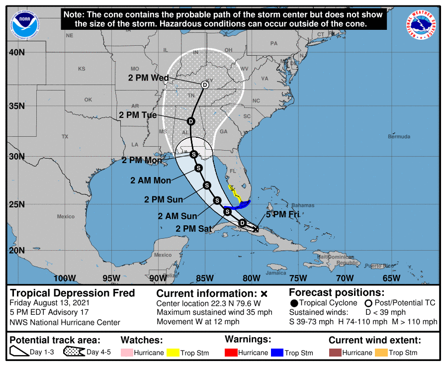
TROPICAL DEPRESSION FRED – 1800 EDT – 8/13/21
Since the 1100 EDT advisory earlier today, Tropical Depression Fred was headed nearly west for several hours. As a result, the forecast track has shifted significantly west, the first real significant shift of the forecast track in several days.
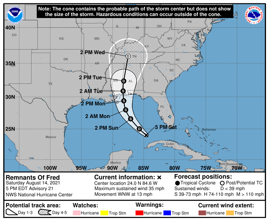
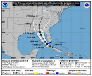
At 500 PM EDT (2100 UTC), the center of Tropical Depression Fred was located near latitude 21.3 North, longitude 75.3 West. The depression is moving toward the west-northwest near 12 mph (19 km/h), and this general motion is expected to continue through Friday. A turn toward the northwest is expected Friday night or Saturday. On the forecast track, Fred is expected to move along or just north of eastern and central Cuba tonight and Friday, and be near the Florida Keys and southern Florida on Saturday.
Maximum sustained winds are near 35 mph (55 km/h) with higher gusts, mainly in squalls to the northeast of the center. Little change in strength is expected through tonight. Slow
strengthening is expected Friday through Saturday, and Fred is forecast to regain tropical storm strength as it nears the Florida Keys and south Florida.
The estimated minimum central pressure is 1012 mb (29.89 inches).
COASTAL WATCHES/WARNINGS AND FORECAST CONE FOR STORM CENTER
SUMMARY OF 0500 PM EDT…2100 UTC…INFORMATION
LOCATION…22.3N 79.6W
ABOUT 15 MI…25 KM SSW OF CAIBARIEN CUBA
ABOUT 210 MI…340 KM SE OF KEY WEST FLORIDA
MAXIMUM SUSTAINED WINDS…35 MPH…55 KM/H
PRESENT MOVEMENT…W OR 280 DEGREES AT 12 MPH…19 KM/H
MINIMUM CENTRAL PRESSURE…1013 MB…29.92 INCHES
SUMMARY OF WATCHES AND WARNINGS IN EFFECT:
A Tropical Storm Warning is in effect for…
* The Florida Keys west of Ocean Reef to the Dry Tortugas
* Florida Bay
A Tropical Storm Watch is in effect for…
* The southwest coast of Florida from Englewood south and east to Ocean Reef
FORECAST DISCUSSION:
The following excerpt is from the Forecast Discussion issued at 1700 EDT today:
“Although there has been a general increase in convection associated with Fred since this morning, the system remains disorganized with the low-level center moving farther inland over central Cuba. Earlier ASCAT data detected an area of 25-27 kt winds over water to the northeast of the center, and based on that data, the initial intensity is held at 30 kt, which could be a little generous.
Since the previous advisory, Fred has been moving nearly due westward, but the longer-term motion is estimated to be 280/10 kt. The cyclone is nearing the western periphery of a subtropical ridge that is centered over the western Atlantic. This should cause Fred
to turn west-northwestward tonight, and then northwestward on Saturday. The latest interpolated guidance that was initialized with the more southward and westward 18Z initial position shows a wider or more gradual northwestward turn, and therefore has shifted significantly westward, especially in the short term. However, the global models fields track the 850-mb vorticity center more along the northern coast of Cuba and some of those models suggest a center re-formation could occur on Saturday near the north coast of Cuba or over the Straits of Florida. As a result, the first 24-36 hours of the track forecast has been adjusted about a degree westward, but it is not as far west as the trackers, leaving open the possibility that a center re-formation could occur. After that time, the NHC forecast lies along the eastern side of the guidance envelope in best agreement with the 12Z GFS. Some additional westward adjustments may be necessary until the track guidance stabilizes. It is worth noting that it isn’t too surprising to see these type of models shifts with a system that remains quite disorganized.
Fred remains within an area of moderate southwesterly vertical wind shear, and the model guidance generally indicates that this shear will continue during the next day or so. Since it will also take time for the system to recover after its passage over Cuba, only gradual strengthening is indicated during the next day or two. After that time, the system could be in a somewhat more favorable environment, and the NHC intensity forecast calls for some
strengthening until Fred reaches the northern Gulf Coast, which now doesn’t occur until around 72 hours with the wider turn shown in the track forecast. The NHC intensity forecast lies between the various consensus aids, the statistical guidance, and the HWRF
model, which all generally show the system peaking in 60-72 hours. The intensity forecast remains of lower-than-normal confidence due to Fred’s continued interaction with land.
Users are reminded to not focus on the exact forecast track as heavy rainfall, gusty winds, and a chance of tornadoes will extend far to northeast and east of the center, and those hazards are likely to still affect portions of the Florida peninsula, despite the recent shift in the forecast track.”
SITUATION AND ACTIONS:
A Tropical Storm Watch is now in effect for coastal Charlotte, coastal Lee, coastal Collier, and Monroe Counties, including the western part of the Florida Keys. At the present time there is a Tropical Storm Watch for Coastal Charlotte County only. There are no Tropical Storm Warnings for the ARRL West Central Florida Section.
Five ARES groups in the ARRL West Central Florida Section, have reported going to a Level 3 Activation, which is a Standby/Monitoring mode. As a result, the ARRL West Central Florida Section Alert Level continues at Level 3. Note: The Section ARES Alert Level simply reflects the activation status of local ARES groups in the ARRL West Central Florida Section. Each ARES groups activates at the request of their served agencies and or in accordance with their local ARES plan.
All ARES, ACS, and CERT personnel are encouraged to continue to check each advisory issued by the National Hurricane Center in Miami and any advisories or Hurricane Local Statements issued by the National Weather Service Office in Ruskin. All ARES, ACS, and CERT should stay in communications with their respective organizations in case of requested activation. All ARES, ACS, and CERT personnel should rush to completion any equipment checks or supply shortages shortly, in case of an unlikely change in the forecast track.
LATEST NATIONAL HURRICANE CENTER INFORMATION:
Public Advisories: https://www.nhc.noaa.gov/text/refresh/MIATCPAT1+shtml/112039.shtml
Forecast Advisory: https://www.nhc.noaa.gov/text/refresh/MIATCMAT1+shtml/112039.shtml?
Forecast Discussion: https://www.nhc.noaa.gov/text/refresh/MIATCDAT1+shtml/112040.shtml
CONCLUSION
The next WCF SECTION SPECIAL BULLETIN on Tropical Storm Fred will be issued tomorrow at around 1800 EDT, unless conditions warrant a bulletin sooner.