WCF SECTION SPECIAL BULLETIN #24-05 – 2000 EDT – 9/23/24
POTENTIAL TROPICAL CYCLONE NINE – 2000 EDT – 9/23/24
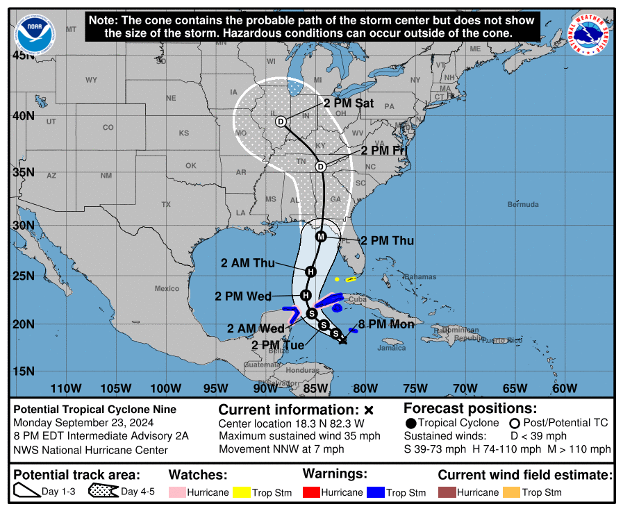
The area of disturbed weather that has been traveling across the southern Caribbean sea for about the last week, is now starting to get better organized. Yesterday, it was designated Invest 97L. As Invest 97L has been getting better organized, and in keeping with modern practice, the National Hurricane Center, declared Invest 97L to be Potential Tropical Cyclone Nine. This system is expected to intensify into Tropical Storm Helene on Tuesday, and once it enters the Gulf of Mexico on Wednesday, rapidly intensify to a Category 1 Hurricane on Wednesday, and further intensify into a Category 3 Hurricane, a major hurricane, on Thursday before making landfall in the Florida panhandle. This storm once it enters the Gulf of Mexico is expected to increase in forward speed as well running in between a low pressure area to the west and high pressure to the east.
COASTAL WATCHES/WARNINGS AND FORECAST CONE FOR STORM CENTER
SUMMARY OF 2000 EST…0000 UTC…INFORMATION
——————————————————————————-
LOCATION…18.3N 82.3W
ABOUT 100 MI…160 KM SW OF GRAND CAYMAN
ABOUT 300 MI…485 KM SE OF THE WESTERN TIP OF CUBA
MAXIMUM SUSTAINED WINDS…35 MPH…55 KM/H
PRESENT MOVEMENT…NNW OR 345 DEGREES AT 7 MPH…11 KM/H
MINIMUM CENTRAL PRESSURE…1002 MB…29.59 INCHES
SUMMARY OF WATCHES AND WARNINGS IN EFFECT:
A Hurricane Watch is in effect for…
* Cabo Catoche to Tulum, Mexico
* Cuban province of Pinar del Rio
A Tropical Storm Warning is in effect for…
* Grand Cayman
* Rio Lagartos to Tulum, Mexico
* Cuban provinces of Artemisa, and Pinar del Rio, and the Isle of
Youth
A Tropical Storm Watch is in effect for…
* Dry Tortugas
* Lower Keys south of the Seven Mile Bridge
A Tropical Storm Warning means that tropical storm conditions are expected somewhere within the warning area, in this case within the next 24 to 36 hours.
A Hurricane Watch means that hurricane conditions are possible within the watch area. A watch is typically issued 48 hours before the anticipated first occurrence of tropical-storm-force winds, conditions that make outside preparations difficult or dangerous.
A Tropical Storm Watch means that tropical storm conditions are possible within the watch area, generally within 48 hours.
FORECAST DISCUSSION:
The following excerpt is from the Forecast Discussion issued at 1700 EDT today:
Showers and thunderstorms associated with the disturbance are gradually becoming better organized this afternoon, although the convection is mostly confined to the eastern portion of the circulation. Scatterometer winds and aircraft data indicate the disturbance still lacks a well-defined center, with very light winds noted on the west side of the broad, elongated circulation. The scatterometer data did show stronger winds near the convection on the east side, and based on this along with the aircraft winds, the initial intensity is raised to 30 kt for this advisory.
The estimated initial motion is north-northwestward (345/6 kt), but the disturbance should turn more northwestward during the next day or so. The NHC forecast shows the center of the system passing between the Yucatan Peninsula and the western tip of Cuba late Tuesday night, then moving into the southern Gulf of Mexico on Wednesday. From there, the flow between a deep-layer trough over the central United States and a ridge over the western Atlantic should cause the system to accelerate northward to north-northeastward across the eastern Gulf of Mexico and toward the northeastern Gulf Coast and Florida Panhandle through Thursday. The track guidance is very tightly clustered on this solution, and the official NHC forecast is essentially an update of the previous one.
The moderate southwesterly shear over the disturbance is expected to diminish over the next day or two, which should allow the system to become better organized and consolidate over deep, warm waters in a very moist environment. Once the system develops an inner core, these conditions should allow it to significantly strengthen. The NHC forecast still calls for the system to become a hurricane on Wednesday, with continued intensification thereafter while it moves over the eastern Gulf of Mexico. Once again, the statistical RI guidance (SHIPS and DTOPS) show a 65-kt increase in 72 h is very likely, and the updated NHC forecast now explicitly shows the system reaching major hurricane intensity on Thursday. This intensity forecast still lies below the consensus aids, with the regional hurricane models and the GFS showing even more deepening.
Note that the system is expected to grow in size while it traverses the Gulf. Thus, the storm surge, wind, and rainfall impacts will extend well away from the center, particularly to the east of the system. In addition, the fast forward speed as it approaches the coast will likely result in farther inland penetration of gusty winds over parts of the southeastern United States after landfall.
SITUATION AND ACTIONS:
At the present time there are not any watches or warnings in effect for the ARRL West Central Florida Section. However by this time tomorrow that situation will no doubt have changed and there will be watches or warnings in effect.
In anticipation of the arrival of what will become Hurricane Helene, Florida Governor Ron Desantis signed Executive Order 24-208, which is an emergency declaration for 41 Florida counties. For the full text of the declaration please go to https://www.flgov.com/2024/09/23/memorandum-executive-order-number-24-208-emergency-management-potential-tropical-cyclone-nine/ Included in this declaration are the following ARRL West Central Florida Section counties: Pasco, Pinellas, Hillsborough, Manatee, Sarasota, and Charlotte Counties. At the present time the inland ARRL West Central Florida Section counties of Desoto, Hardee, Highlands, and Polk Counties are not included. However this could change if the path of the storm significantly changes.
Bill Fetta N7CGG, Section Emergency Coordinator raised the ARES Alert Level to a Level 3, which is a standby mode, in case of activation of any ARES groups in the ARRL West Central Florida Section. At the present time no ARES groups have been requested to activate. All ARES personnel are strongly encouraged to stay in communication with your respective ARES group leadership, as this may change in the next 12 to 24 hours.
The West Central Florida Skywarn Net will be activated on the NI4CE Analog and the NI4CE NXDN repeater system (talkgroup 1299), once severe weather begins to threaten the NWS Forecast Office Ruskin Coverage Warning Area.
All ARES, ACS, and CERT personnel should work to complete any last minute preparations and do any last minute checks on their equipment in case they are requested to activate.
All ARES, ACS, and CERT personnel are encouraged to continue to check each advisory issued by the National Hurricane Center in Miami on Potential Tropical Cyclone Nine and the Tropical Weather Outlook issued four times daily by the National Hurricane Center.
LATEST NATIONAL HURRICANE CENTER INFORMATION:
Public Advisories: https://www.nhc.noaa.gov/text/refresh/MIATCPAT4+shtml/232347.shtml?
Forecast Advisory: https://www.nhc.noaa.gov/text/refresh/MIATCMAT4+shtml/232051.shtml?
Forecast Discussion: https://www.nhc.noaa.gov/text/refresh/MIATCDAT4+shtml/232053.shtml?
Latest GOES Satellite Floater Images and Loop: https://www.star.nesdis.noaa.gov/GOES/floater.php?stormid=AL092024#navLink
CONCLUSION
The next WCF SPECIAL BULLETIN will be tomorrow evening right after the 2000 EDT intermediate advisory on Potential Tropical Cyclone Nine.