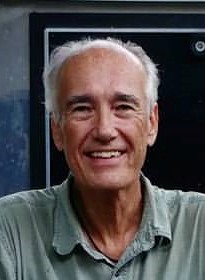
WCF SECTION SPECIAL BULLETIN #20-15 – 1900 EST – 11/05/20

TROPICAL DEPRESSION ETA – 1900 EST – 11/05/20

After a very busy and exhausting hurricane season, that has included twenty eight named tropical storms, of which eleven became hurricanes and five were Category 3 or greater, and with 11 United States coastal landfalls, we must now focus on Tropical Depression Eta, which made landfall on the coast of Nicaragua on Tuesday afternoon.  Eta has been slowly creeping west through Nicaragua and Honduras and is now re-emerging over the southwestern Carribean Sea.  With the increased threat to the State of Florida, these daily special bulletins commence distribution.

SUMMARY OF 600 PM CST…0000 UTC…INFORMATION

LOCATION…16.0N 87.8W
ABOUT 65 MI…100 KM WNW OF LA CEIBA HONDURAS
MAXIMUM SUSTAINED WINDS…35 MPH…55 KM/H
PRESENT MOVEMENT…NNW OR 340 DEGREES AT 8 MPH…13 KM/H
MINIMUM CENTRAL PRESSURE…1004 MB…29.65 INCHES

SUMMARY OF WATCHES AND WARNINGS IN EFFECT:

A Tropical Storm Watch is in effect for…
* The Cayman Islands

DISCUSSION:

The following excerpts are from the Forecast Discussion issued at 1600 EST today, “The low-level circulation of Eta has become disorganized to the point that the system more resembles a remnant low than a tropical cyclone. However, the system continues to produce convection in an area just north and northwest of the estimated center position, as well as in a cluster well to the northeast. Based on this, and the expectation that the system will start re-developing during the next several hours as it moves back over water, Eta is maintained as a tropical depression for this advisory. The initial intensity is increased to 30 kt based on scatterometer data, with those winds occuring well to the northeast of the center.

The center appears to be just south of the northwestern coast of Honduras, and the initial motion is an uncertain 330/7. During the next 24 h, Eta should recurve northeastward in southwesterly flow between a ridge over the central Caribbean and a developing mid- to upper-level trough over the central Gulf of Mexico. This motion should persist through about 72 h. After that, the trough is forecast to become a closed low in the vicinity of western Cuba,with Eta turning to the west-northwest as it interacts or merges with the low. While the models are in good agreement with the synoptic pattern, they are in poor agreement on the details of the track. The forecast tracks show possible landfalls in Cuba anywhere between 77W-83W, and after the turn some of the tracks are as far north as southern Florida while other stay over Cuba. In addition, there is a significant speed difference between the faster GFS/HWRF/HMON and the slower Canadian/ECMWF/UKMET. The low-confidence official forecast compromises between these various extremes and is not changed much from the previous forecast.

Little change in strength is expected during the next 12 h or so as Eta starts to re-organized over water. After that, gradual strengthening is expected until the system reaches Cuba in about 72 h, with the main limiting factor being increasing southwesterly shear during that time. From 72-120 h, there is a possibility that Eta will take on subtropical or hybrid characteristics as it interacts with the developing upper-level low. The intensity forecast will be held at 50 kt during that time due to this interaction. The new intensity forecast has only minor tweaks from the previous forecast. However, it lies below the bulk of the intensity guidance for the first 60 h and above the bulk of the guidance from 72-120 h.

The new forecast track, intensity, and wind radii require a Tropical Storm Watch for the Cayman Islands at this time. A Tropical Storm Watch will likely be required for portions of Cuba later tonight or on Friday.”

SITUATION AND ACTIONS:

At the present time the impacts to the southern part of the State of Florida and the ARRL West Central Florida Section are not that well known due to the course of the storm not being more defined.  At the present time, there have not been any requests from any of our served agencies for communications services via amateur radio.  All ARES, ACS, and CERT personnel should take this opportunity to re-check any equipment and supplies that would be used, just in case our services are requested.   Everyone is highly encouraged to continue to check the latest advisories issued by the National Hurricane Center in Miami.  Please note that the advisories are now being issued at 0400, 1000, 1600, and 2200 hours Eastern Standard Time, due to returning to Eastern Standard Time last Sunday.

LATEST NATIONAL HURRICANE CENTER INFORMATION:

Public Advisories:  https://www.nhc.noaa.gov/text/refresh/MIATCPAT4+shtml/052330.shtml?
Forecast Advisory:  https://www.nhc.noaa.gov/text/refresh/MIATCMAT4+shtml/052053.shtml?
Forecast Discussion:  https://www.nhc.noaa.gov/text/refresh/MIATCDAT4+shtml/052054.shtml?


The next WCF SECTION SPECIAL BULLETIN will be issued around 1900 EST tomorrow evening, unless conditions warrant a sooner release.

END OF SPECIAL BULLETIN

WCF SECTION PRESS RELEASE #20-54

NOMINATIONS FOR 2020 WHITE AWARD ARE NOW OPEN

Nominations are now being accepted for the 2020 White Award.  This award is given each year to the amateur radio operator who has made the greatest contribution to amateur radio in the ARRL West Central Florida Section. The White Award was instituted in 2016 in honor of Ellen White W1YL, who was a Section Communications Manager in the 1950’s, which was changed to Section Manager in 1979, and an ARRL staffer in numerous positions at ARRL Headquarters until her retirement.

Nominations can be made on the Contact Form on the Section website at http://arrlwcf.org/section-forms/contact-info/.  Nominations will close on Saturday December 5th, 2020 and the award will be presented to the recipient on Saturday December 12th, 2020 during the ARRL forum at the Tampa Bay Hamfest.

For more information on the White Award you may go to the Section website at http://arrlwcf.org/wcf-special-events/white-award/

END OF PRESS RELEASE


WCF SECTION PRESS RELEASE #20-53

USA MOTOR COACH HAMFEST AND ROD RUN SCHEDULED FOR 11/14/20


The USA Motor Coach Hamfest and Rod Run is scheduled for Saturday November 14, 2020.  The hamfest will be held at the USA Motor Coach facility located at 4501 Ulmerton Road, in Clearwater.  This hamfest was organized by members of SPARC to replace the SPARCFest that was scheduled for November 14, 2020 but was cancelled due to COVID 19 restrictions placed upon Freedom Lake Park in Pinellas Park, FL.

The USA Motor Coach Hamfest will be a hamfest tailgate and hot rod car show combined together.  This will give amateur radio operators a somewhat unique opportunity to go to a tailgate hamfest and hot rod car show all at the same place and time.  The hamfest will open at 0800 hours and there is no admission cost for those tailgating and or those attending.  The organizers request that you wear a face mask when attending.

For all the details of the USA Motor Coach Hamfest and Rod Run you may go to the following website, which will include directions, a map, and other information:  https://bw.billl.net/usa-coach-ham-fest-and-rod-run/.

END OF PRESS RELEASE

WCF SECTION PRESS RELEASE #20-52

SPARCFEST 2020 CANCELLED – TAMPA BAY HAMFEST STILL SCHEDULED

On Wednesday October 14, the St. Petersburg Amateur Radio Club, as known by the name SPARC, announced on their website that the SPARCFEST 2020 that was to be held on Saturday November 14, 2020 at Freedom Lake Park in Pinellas Park was cancelled.  According to a statement on the SPARC website, the cancellation was due to a limitation of 50 persons being able to be in Freedom Lake Park.

On Wednesday October 15, the Florida Gulf Coast Amateur Radio Council met via Zoom and decided to go ahead and conduct the Tampa Bay Hamfest 2020 but with some modifications.  Bill Willams AG4QX, President of the Florida Gulf Coast Amateur Radio Council, issued the following statement on the FGCARC website, “October 14th, the Florida Gulf Coast Amateur Radio Council met and decided to have the Hamfest as scheduled but with some changes to accommodate the Covid 19 situation.  The major change is that we will not be using the Expo building.  The whole Hamfest will take place in the block between Lemon St and Woodrow Wilson St including the two buildings there.  Most of the selling will be in the tailgate area.  Everything is not yet settled so we have suspended sales of tickets for a few weeks while details are worked out.  Thank you for your patience and stay tuned for further details.”  The ARRL West Central Florida Section is still planning on having a booth at the Tampa Bay Hamfest and to hold the ARRL forum as circumstances permit.  As more details are worked out, further information will be released in a future WCF SECTION PRESS RELEASE.

END OF PRESS RELEASE

WCF SECTION PRESS RELEASE #20-51

ARRL WCF SECTION ARES MEETING FALL 2020 TO BE HELD VIA ZOOM.

The Fall 2020 ARRL West Central Florida Section ARES Meeting will be held on Saturday October 17, 2020 at 1300 EDT, as a Zoom meeting, instead of a “face to face” meeting that was originally planned earlier this year, due to the COVID-19 situation.  The information to log into the Zoom meeting is located in the Section events calendar at the following address: http://arrlwcf.org/event/wcf-section-ares-meeting-fall-2020/.

The Fall 2020 ARRL West Central Florida Section ARES Luncheon is cancelled due to the cancellation of the in-person meeting.

The Zoom meeting will be open for attendees to check in 15 minutes before the meeting is scheduled to start at 1300, to allow participants time to log in and be sure their video and or audio is functioning.  Everyone is welcome to attend the Zoom meeting, but due to the terms of our Zoom account we are limited to a seating of 100.

END OF PRESS RELEASE

WCF SECTION PRESS RELEASE #20-50

PASCO COUNTY HAMFEST FALL 2020 IS CANCELLED

On Monday September 14,2020, it was publicly announced that the Pasco County Fall Hamfest 2020, that had been scheduled for Saturday September 26, 2020, had been cancelled.  Don Nystrom KA2KDP, President of the Suncoast Amateur Radio Club, which sponsors the bi-annual Pasco County Hamfest, stated that the Gunn Highway Flea Market which had provided space for the hamfest had recently been sold and was no longer available to hold the hamfest.

END OF PRESS RELEASE


WCF SECTION PRESS RELEASE #20-49

TECHCON 2021 DATE AND VENUE SET

The 7th Annual TECHCON date and venue have been set.  The 7th Annual TECHCON, the ARRL West Central Florida Section Technical Conference, will be held on Friday February 26, 2021 and Saturday February 27, 2021.  The location for the 7th Annual TECHCON will be at the Polk County Emergency Operations Center located between Winter Haven and Lakeland.  The Friday Afternoon Workshop topic is to be determined.

If the Polk County Emergency Operations Center becomes unavailable due to the COVID-19 situation, the conference will be transitioned to a virtual conference via Zoom Teleconferencing.

Registration is now open for the 7th Annual TECHCON.  If you are planning on attending TECHCON, please register for TECHCON by filling out a TECHCON Registration Form on the Section website at http://arrlwcf.org/section-forms/wcftechconfregistration/. Some of our previous presenters at TECHCON are planning on returning for the 7th Annual TECHCON, but we are looking for new presenters for the 7th Annual TECHCON as well.  If you wish to be a presenter, please fill out the TECHCON Registration Form and our current Section Manager Darrell Davis KT4WX will get back with you.  For more information on TECHCON you may go to the TECHCON web page on the Section website at http://arrlwcf.org/wcf-special-events/wcftechconference/.

END OF PRESS RELEASE

WCF SECTION PRESS RELEASE #20-48

THE WCF PRESSER ISSUE #53 FOR SEPTEMBER 2020 IS NOW PUBLISHED

The WCF PRESSER Issue #53 for September 2020, has been published on the Section website.  An announcement of the publication of the WCF PRESSER will be disseminated on the ARRL remailer shortly. If anyone has any information that is amateur radio related that you would like to go into the next issue of THE WCF PRESSER, please send that to our newsletter editor, Jim Weslager K3WR via email at weslager@gmail.com.

For the PDF version of this newsletter and past issues in PDF format go to http://arrlwcf.org/home/the-wcf-section-presser-arrl-west-central-florida-section-news/.

END OF PRESS RELEASE

WCF SECTION SPECIAL BULLETIN #20-14 – 1800 EDT – 9/15/20 – FINAL

HURRICANE SALLY – 1700 EDT – 9/15/20

Hurricane Sally is now finally moving north towards the Mississippi and Alabama coastline but very slowly.  Landfall is further to the east than was expected this time yesterday but is expected sometime tomorrow.  The biggest threat to southern Mississippi and Alabaman may be flooding as well as moderate wind damage.  Tropical Storm Warnings remain for the western Florida panhandle and a Hurricane Warning is in effect for extreme western Florida panhandle.   Storm Surge Warnings are now in efffect for the extreme western Florida panhandle.

SUMMARY OF 0500 PM CDT…2100 UTC…INFORMATION

LOCATION…29.5N 88.1W
ABOUT 85 MI…135 KM S OF MOBILE ALABAMA
ABOUT 90 MI…140 KM SW OF PENSACOLA FLORIDA
MAXIMUM SUSTAINED WINDS…80 MPH…130 KM/H
PRESENT MOVEMENT…N OR 350 DEGREES AT 2 MPH…4 KM/H
MINIMUM CENTRAL PRESSURE…979 MB…28.91 INCHES

SUMMARY OF WATCHES AND WARNINGS IN EFFECT:

A Storm Surge Warning is in effect for…
* Mouth of the Mississippi River to the Okaloosa/Walton County Line Florida
* Mobile Bay

A Hurricane Warning is in effect for…
* East of Bay St. Louis to Navarre Florida

A Tropical Storm Warning is in effect for…
* East of Navarre Florida to Indian Pass Florida
* Bay St. Louis westward to Grand Isle Louisiana

DISCUSSION:

The following excerpts are from the Forecast Discussion issued at 1700 EDT today, “Sally has been inching its way toward the north-central Gulf Coast today. The overall structure of the storm has remained about the same during the day with a large ragged eye in apparent in radar
imagery. A NOAA P-3 aircraft that has been sampling the storm since late this morning has reported peak flight-level winds of 76 kt, and NWS Doppler radar has shown velocities of 75-80 kt at around 7000 ft. The intensity was reduced to 70 kt on the 1800 UTC intermediate advisory and remains at that value for this advisory.

Radar and aircraft fixes show that Sally has been moving very slowly toward the north or 350/2 kt. The track forecast philosophy remains
unchanged from the previous advisory. Sally is currently located within an area of weak steering flow between a couple of mid-level ridges to its east and west. A weak mid-level trough over the south-central United States is forecast to slide eastward over the next few days, which should cause Sally to turn north-northeastward and then northeastward over the next 24-36 hours. Sally’s forward speed is expected to remain quite slow over the next 24-48 hours, but the guidance has trended slightly faster after that time. The slow forward speed is likely to result in a historical rainfall event for the north-central Gulf Coast. It may sound like a broken record, but the track guidance has again shifted eastward during the first 24-36 hours, and the NHC forecast has been adjusted accordingly. Since Sally has a large wind field, and storm surge and rainfall hazards extend far from the eye, users should not focus on the exact forecast track or specific location and timing of landfall as strong winds and bands of heavy rainfall are already affecting the Gulf Coast and will continue to do so for quite some time.

The combination of upwelling and moderate westerly shear is likely to result in little change in strength prior to Sally moving onshore. Once the center of the hurricane moves onshore, rapid weakening is expected and the global models indicate that the circulation will becoming elongated along a frontal boundary in 3 to 4 days.”

SITUATION AND ACTIONS:

A Tropical Storm Warning is in effect for the portions of Gulf, Bay, southern part of Walton and Okaloosa Counties.  A Hurricane Warning is in effect for Santa Rosa and Escambia Counties.  Storm Surge Warning is in effect for Escambia, Santa Rosa, and Oklaloosa Counties.

The only warnings in effect for the ARRL West Central Florida Section are Flood Warnings in effect for portions of the Peace River in Polk County near Bartow, the Myakka River at Myakka River State Park in Sarasota County, and Cypress Creek at State Road 54 Worthington Gardens which will affect Pasco County.  These are from the recent rains from when Hurricane Sally passed by over the weekend and on Monday.

The threat from Hurricane Sally have been tremendously diminished to the ARRL West Central Florida Section.   Everyone should continue monitoring the latest advisories issued four times a day by the National Hurricane Center and for any further watches and or warnings issued by the National Weather Service office in Ruskin.

LATEST NATIONAL HURRICANE CENTER INFORMATION:

Public Advisories:  https://www.nhc.noaa.gov/text/refresh/MIATCPAT4+shtml/120243.shtml?
Forecast Advisory:  https://www.nhc.noaa.gov/text/refresh/MIATCMAT4+shtml/120242.shtml?
Forecast Discussion:  https://www.nhc.noaa.gov/text/refresh/MIATCDAT4+shtml/120243.shtml?


This will be the last WCF SECTION SPECIAL BULLETIN on Hurricane Sally unless conditions dramatically change and the threat to the ARRL West Central Florida Section is once again increased.

END OF SPECIAL BULLETIN

WCF SECTION SPECIAL BULLETIN #20-13 – 1800 EDT – 9/14/20

HURRICANE SALLY – 1700 EDT – 9/14/20

Sally, intensifying to a category one hurricane earlier today, continues to move away from the State of Florida towards a likely landfall in eastern Louisiana or Mississippi sometime late on Tuesday or early on Wednesday.  Tropical Storm Warnings remain for the western Florida panhandle and a Hurricane Warning is now in effect for extreme western Florida panhandle..

SUMMARY OF 0500 PM CDT…2100 UTC…INFORMATION

LOCATION…28.8N 87.4W
ABOUT 105 MI…170 KM E OF THE MOUTH OF THE MISSISSIPPI RIVER
ABOUT 145 MI…230 KM SE OF BILOXI MISSISSIPPI
MAXIMUM SUSTAINED WINDS…100 MPH…155 KM/H
PRESENT MOVEMENT…WNW OR 300 DEGREES AT 6 MPH…9 KM/H
MINIMUM CENTRAL PRESSURE…987 MB…29.15 INCHES

SUMMARY OF WATCHES AND WARNINGS IN EFFECT:

A Storm Surge Warning is in effect for…
* Port Fourchon Louisiana to the Okaloosa/Walton County Line Florida
* Lake Pontchartrain, Lake Maurepas, and Lake Borgne
* Mobile Bay

A Hurricane Warning is in effect for…
* Morgan City Louisiana to the Navarre Florida
* Lake Pontchartrain and Lake Maurepas including metropolitan New Orleans

A Tropical Storm Warning is in effect for…
* East of of Navarre Florida to Indian Pass Florida

DISCUSSION:

The following excerpts are from the Forecast Discussion issued at 1700 EDT today, “After the rapid spin up of the inner core late this morning, the most recent aircraft passes through the center have not found any higher flight-level winds, however there have been a few SFMR winds
of 85-90 kt reported. Using a blend of the flight-level and SFMR winds the initial intensity has been increased to 85 kt for this advisory. The next Air Force and NOAA aircraft have begun to sample the storm. Now that Sally has developed an inner core, the favorable atmospheric and ocean conditions of low vertical wind shear and warm water should allow for additional strengthening tonight while the system moves over the north-central Gulf of Mexico, and Sally could approach major hurricane strength. On Tuesday, the global models are predicting an increasing in
southwesterly flow aloft, and this increase in shear, the potential for land interaction, and some upwelling over the shallower shelf waters over the northern Gulf should slow the intensification process. The NHC intensity forecast is again near the upper-end of the guidance envelope in best agreement with the HWRF and HFIP corrected consensus models.  Sally did not move much earlier today as the center re-formation took place, but it appears that a slow west-northwestward to northwestward motion has resumed. Weak ridging over the southeastern United States is expected to steer Sally generally west-northwestward through early Tuesday. After that time, steering currents weaken and a slow northward motion is forecast as a weak mid-level trough develops over the the central United States. This trough is forecast to slide eastward, allowing Sally to begin a slow north-northeastward or northeastward motion. The specific timing and location of the turn will be critical as to the eventual
location and timing of landfall along the north-central Gulf Coast.  The UKMET and ECMWF models show a more northeastward motion after
the turn and have trended eastward, with the ECMWF much slower than the remainder of the guidance. The NHC track has been adjusted
eastward, and this requires and eastward extension of the hurricane warning. The new track most closely follows the GFS and it ensemble
mean, but lies to the west of the various consensus aids, so some additional eastward adjustments could be needed in subsequent advisories.

Given the uncertainty in the timing and location of the northward turn and the lack of well-defined steering currents, users are reminded to not focus on the exact forecast track or the specific timing and location of landfall. Hurricane-force winds, dangerous storm surge, and flooding rainfall will affect a large portion of the north-central Gulf Coast during the next few days.”

SITUATION AND ACTIONS:

A Tropical Storm Warning is in effect for the coastal portions of Gulf, Bay, southern part of Walton and Okaloosa Counties.  A Hurricane Warning is in effect for the southern parts of Santa Rosa and Escambia Counties. The Tropical Storm Watch for coastal Franklin County was discontinued. The only warnings in effect for the ARRL West Central Florida Section are Flood Warnings in effect for portions of the Peace River in Polk County near Bartow, the Myakka River at Myakka River State Park in Sarasota County, and Cypress Creek at State Road 54 Worthington Gardens which will affect Pasco County.  The Flood Watch that had been in effect for the entire Ruskin CWA for the last several days was allowed to expire.

At the present time, the primary threat to the ARRL West Central Florida Section continues to be the potential for flooding from any further rainfall.  Rain chances will remain elevated for This threat will continue to diminish as Hurricane Sally moves away from the State of Florida.  Everyone should continue monitoring the latest advisories issued four times a day by the National Hurricane Center and for any further watches and or warnings issued by the National Weather Service office in Ruskin.

If Hurricane Sally continues its present course away from Florida, these bulletins will be discontinued most likely after tomorrow, being the threat to the State of Florida will be diminished.

LATEST NATIONAL HURRICANE CENTER INFORMATION:

Public Advisories:  https://www.nhc.noaa.gov/text/refresh/MIATCPAT4+shtml/120243.shtml?
Forecast Advisory:  https://www.nhc.noaa.gov/text/refresh/MIATCMAT4+shtml/120242.shtml?
Forecast Discussion:  https://www.nhc.noaa.gov/text/refresh/MIATCDAT4+shtml/120243.shtml?


The next WCF SECTION SPECIAL BULLETIN on Hurricane Sally will issued following the 1700 EDT advisory tomorrow for Hurricane Sally, unless conditions warrant a release sooner.

END OF SPECIAL BULLETIN

1 22 23 24 25 26 56