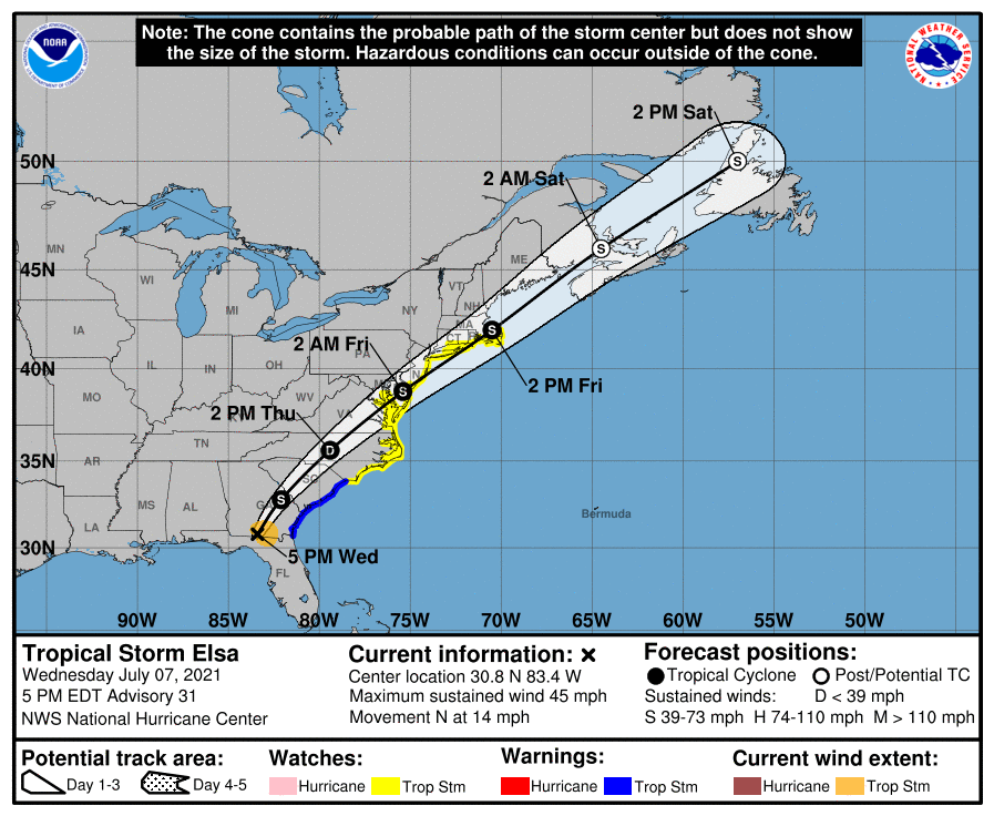
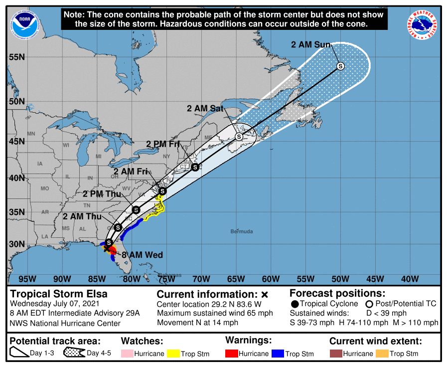
TROPICAL STORM ELSA – 0800 EDT – 7/07/21
Tropical Elsa Elsa obtained hurricane status late yesterday evening and earlier this morning, slightly weakened to a high end Tropical Storm.
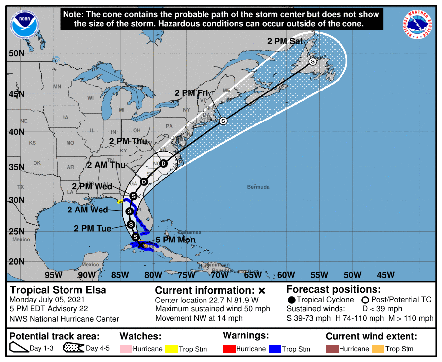
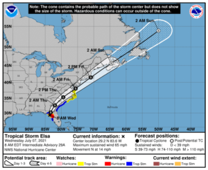
At 800 AM EDT (1200 UTC), the center of Tropical Storm Elsa was located by an Air Force Hurricane Hunter aircraft and NWS Doppler radars near latitude 29.2 North, longitude 83.6 West. Elsa is moving toward the north near 14 mph (22 km/h), and a general northward motion is expected to continue through this afternoon. A turn toward the north-northeast is expected late this afternoon or tonight, followed by a faster northeastward motion by late Thursday. On the forecast track, Elsa will make landfall along the north Florida Gulf coast by late this morning or this afternoon. The storm should then move across the southeastern and mid-Atlantic United States through Thursday.
The primary impact to the coastal counties ARRL West Central Florida Section will be from storm surge, tropical storm force winds but soon begin to diminish today. The primary impact to the inland counties of the ARRL West Central Florida Section will flooding due to excessive rain especially near rivers.
SUMMARY OF 800 AM EDT…1200 UTC…INFORMATION
———————————————-
LOCATION…29.2N 83.6W
ABOUT 35 MI…55 KM W OF CEDAR KEY FLORIDA
ABOUT 115 MI…185 KM NW OF TAMPA FLORIDA
MAXIMUM SUSTAINED WINDS…65 MPH…100 KM/H
PRESENT MOVEMENT…N OR 360 DEGREES AT 14 MPH…22 KM/H
MINIMUM CENTRAL PRESSURE…999 MB…29.50 INCHES
SUMMARY OF WATCHES AND WARNINGS IN EFFECT:
A Storm Surge Warning is in effect for…
* West coast of Florida from the Middle of Longboat Key to the Aucilla River, including Tampa Bay
A Hurricane Warning is in effect for…
* West coast of Florida from Chassahowitzka to the Steinhatchee River
A Tropical Storm Warning is in effect for…
* West coast of Florida from south of Chassahowitzka to the Middle of Longboat Key
* West coast of Florida north of the Steinhatchee River to Ochlockonee River
* Mouth of St. Marys River, Georgia to Little River Inlet, South Carolina
A Storm Surge Watch is in effect for…
* West of the Aucilla River to the Ochlockonee River, Florida
A Tropical Storm Watch is in effect for…
* North of Little River Inlet, South Carolina to Chincoteague, Virginia
* Pamlico and Albemarle Sounds
DISCUSSION:
The following excerpt is from the Forecast Discussion issued at 0800 EDT today:
“The central convection associated with Elsa dissipated for a time earlier this morning, although the latest radar and satellite imagery shows a new band forming in the northern semicircle. This decrease was likely caused by a combination of shear and dry air
entrainment, and it has caused the cyclone to weaken. Aircraft and surface observations indicate the central pressure has risen to near 1004 mb, and the initial intensity is decreased to a possibly generous 55 kt based on aircraft and Doppler radar data.
After a slight jog to the left, the storm has resumed a motion of 360/12. This motion should continue for the next 12 h or so until landfall occurs across the northwestern Florida peninsula. Thereafter, a gradual turn toward the north-northeast is expected
by, followed by acceleration toward the northeast as Elsa moves into the mid-latitude westerlies. The forecast guidance has shifted a little to the left since the last advisory, and the new forecast track is also nudged in that direction. The new track lies a little to the right of the various consensus models.
While little change in strength is forecast before landfall, there is a chance that the new convection could cause a short-lived re-intensification. So, based on this possibility a hurricane warning remains in effect for portions of the west coast of Florida. After landfall, Elsa should weaken as it crosses the southeastern United States, followed by some re-intensification as it accelerates back over the Atlantic. The system is expected to
become extratropical by the time it reaches the Canadian Maritimes in 72 h. The new intensity forecast is at the upper edge of the guidance envelope and has only minor adjustments from the previous forecast.”
SITUATION AND ACTIONS:
In the ARRL West Central Florida Section, all Hurricane Warnings have been discontinued. A Tropical Storm Warning and Storm Surge Warning are in effect for Pinellas, Hillsborough, Manatee, and Sarasota Counties. The Tropical Storm Warning for Charlotte County has been discontinued. A Flood Warning is in effect Hardee, Desoto, Manatee, eastern Sarasota, and eastern Charlotte Counties until 1500 EDT today due to excessive rainfall. Flood Warnings are in effect for several rives in Hillsborough, Manatee, and Sarasota Counties until Friday evening. A Flood Watch is in effect for all counties in the ARRL West Central Florida Section until 1400 EDT today.
As of press time, two ARES Groups are still partially activated:
- Pinellas County ARES/ACS has been requested to staff the Emergency Operations Center and two Community Wellness Centers with auxiliary communications beginning yesterday morning at 0900.
- Hillsborough County ARES/RACES has been requested to staff the Hillsborough County Public Safety Operations Complex and a shelter at Riverview High School at approximately 0900 yesterday morning.
As a result ARRL West Central Florida Section ARES remain at a Level 2 activation, which is a partial activation, due to the activation of ARES groups in Hillsborough and Pinellas Counties. Note: Section ARES Activations Levels are simply alert messages, as each ARES group is responsible for his own level of activation.
Other ARES groups in other counties are on standby in case they are requested to activate All of the ARES groups in the ARRL West Central Florida Section have been taking preparedness actions with their equipment and supplies, and monitoring the situation carefully, just in case they are requested to active by their various served agencies.
All ARES, ACS, and CERT personnel should monitor their email and phones for any requests for assistance from their served agencies through their respective chains of command. Please do not self-activate as requests for assistance and or mutual assistance must follow through the proper procedure. Everyone is highly encouraged to continue to check each advisory issued by the National Hurricane Center in Miami and any advisories or Hurricane Local Statements issued by the National Weather Service Office in Ruskin.
LATEST NATIONAL HURRICANE CENTER INFORMATION:
Public Advisories: https://www.nhc.noaa.gov/text/refresh/MIATCPAT4+shtml/052330.shtml?
Forecast Advisory: https://www.nhc.noaa.gov/text/refresh/MIATCMAT4+shtml/052053.shtml?
Forecast Discussion: https://www.nhc.noaa.gov/text/refresh/MIATCDAT4+shtml/052054.shtml?
LATEST NATIONAL WEATHER SERVICE OFFICE INFORMATION.
Hurricane Local Statement – NWS Ruskin: https://forecast.weather.gov/wwamap/wwatxtget.php?cwa=tbw&wwa=hurricane%20local%20statement
Flood Warnings issued: https://forecast.weather.gov/wwamap/wwatxtget.php?cwa=tbw&wwa=flood%20warning
CONCLUSION
The next WCF SECTION SPECIAL BULLETIN will be issued around 1800 EST this evening, following the 1700 EDT advisory on Tropical Storm Elsa, unless conditions warrant a sooner release.