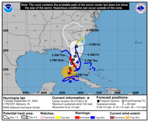
WCF SECTION SPECIAL BULLETIN #21-12 – 1800 EDT – 8/12/21

TROPICAL DEPRESSION FRED – 1800 EDT – 8/12/21

Tropical Storm Fred weakened over night into a Tropical Depression due to land interaction when it crossed Hispanola.

At 500 PM EDT (2100 UTC), the center of Tropical Depression Fred was  located near latitude 21.3 North, longitude 75.3 West. The depression is moving toward the west-northwest near 12 mph (19 km/h), and this general motion is expected to continue through Friday. A turn toward the northwest is expected Friday night or Saturday. On the forecast track, Fred is expected to move along or just north of eastern and central Cuba tonight and Friday, and be near the Florida Keys and southern Florida on Saturday.

Maximum sustained winds are near 35 mph (55 km/h) with higher gusts, mainly in squalls to the northeast of the center.  Little change in strength is expected through tonight. Slow
strengthening is expected Friday through Saturday, and Fred is forecast to regain tropical storm strength as it nears the Florida Keys and south Florida.

The estimated minimum central pressure is 1012 mb (29.89 inches).

COASTAL WATCHES/WARNINGS AND FORECAST CONE FOR STORM CENTER

SUMMARY OF 0500 PM EDT…2100 UTC…INFORMATION

LOCATION…21.3N 75.3W
ABOUT 470 MI…760 KM ESE OF KEY WEST FLORIDA
ABOUT 165 MI…270 KM E OF CAMAGUEY CUBA
MAXIMUM SUSTAINED WINDS…35 MPH…55 KM/H
PRESENT MOVEMENT…WNW OR 295 DEGREES AT 12 MPH…19 KM/H
MINIMUM CENTRAL PRESSURE…1012 MB…29.89 INCHES

SUMMARY OF WATCHES AND WARNINGS IN EFFECT:

A TROPICAL STORM WATCH IS IN EFFECT FOR…
* THE CUBAN PROVINCES OF CIEGO DE AVILA…CAMAGUEY…LAS TUNAS…HOLGUIN…AND GRANMA
* THE FLORIDA KEYS WEST OF OCEAN REEF TO THE DRY TORTUGAS
* THE SOUTHWEST COAST OF FLORIDA FROM BONITA BEACH SOUTH AND EAST TO
OCEAN REEF INCLUDING FLORIDA BAY

FORECAST DISCUSSION:

The following excerpt is from the Forecast Discussion issued at 1700 EDT today:

“Fred remains poorly organized at this time. While the low-level circulation looks more closed than it did earlier, the center is broad and may have multiple vortices rotating around it. Also, while convection has increased from earlier today, there is only minimal convection near the center and little evidence of banding.  The initial intensity remains 30 kt, with those winds likely occurring in squalls to the northeast of the center.

Fred has slowed its forward speed, with the initial motion now 295/10. There is little change to the track forecast philosophy from the previous advisory. The subtropical ridge to the northeast should steer Fred west-northwestward for the first 24-36 h, followed
by a turn toward the northwest as the cyclone approaches the western periphery of the ridge. By 96-120 h, a northward motion is expected as Fred moves into a weakness in the ridge. The track guidance has shifted westward since the previous advisory, most notably after about 24 h. Thus, that portion of the new forecast track has also been nudged a little westward, but it still lies to the east of the various consensus models.

Fred remains in an environment of about 20 kt of westerly vertical wind shear. The shear is expected to persist during the next day or so, and this combined with the current disorganization of the system should prevent significant strengthening during that time. After that, there remains disagreement between the global models on the evolution of the upper-level trough over Florida and the upper-level anticyclone southeast of Fred. Some shear is likely to continue, but there may be a period of more conducive conditions from 36-72 h.  The new intensity forecast is similar to the previous one in calling for slow strengthening through the first 36 h, with a little faster strengthening from 36-72 h. With that being said, the forecast 45-kt peak intensity is near the high end of the intensity guidance.”

SITUATION AND ACTIONS:

A Tropical Storm Watch was issued this afternoon for coastal Collier, coastal Monroe including the western part of the Florida Keys.    At the present time there are no watches or warnings for the ARRL West Central Florida Section.

Two ARES groups in the ARRL West Central Florida Section, have reported going to a Level 3 Activation, which is a Standby/Monitoring mode.  As a result, the ARRL West Central Florida Section Alert Level is now at Level 3.  Note:  The Section ARES Alert Level simply reflects the activation status of local ARES groups in the ARRL West Central Florida Section.  Each ARES groups activates at the request of their served agencies and or in accordance with their local ARES plan.

All ARES, ACS, and CERT personnel are encouraged to continue to check each advisory issued by the National Hurricane Center in Miami and any advisories or Hurricane Local Statements issued by the National Weather Service Office in Ruskin.  All ARES, ACS, and CERT should stay in communications with their respective organizations in case of requested activation.   All ARES, ACS, and CERT personnel should perform any checks on equipment and or supplies in case of activation.

LATEST NATIONAL HURRICANE CENTER INFORMATION:

Public Advisories:  https://www.nhc.noaa.gov/text/refresh/MIATCPAT1+shtml/112039.shtml
Forecast Advisory:  https://www.nhc.noaa.gov/text/refresh/MIATCMAT1+shtml/112039.shtml?
Forecast Discussion:  https://www.nhc.noaa.gov/text/refresh/MIATCDAT1+shtml/112040.shtml

CONCLUSION

The next WCF SECTION SPECIAL BULLETIN on Tropical Storm Fred will be issued tomorrow at around 1800 EDT, unless conditions warrant a bulletin sooner.

WCF SECTION SPECIAL BULLETIN #21-11 – 1800 EDT – 8/11/21

TROPICAL STORM FRED – 1800 EDT – 8/11/21

Potential Tropical Cyclone Six, which had been designated a Potential Tropical Cyclone at 1700 EDT on Monday August 9th, was upgraded to Tropical Storm Fred at 2300 EDT on Tuesday August 10th. With portions of the State of Florida now within both the 5 day and 3 day cone, WCF SECTION SPECIAL BULLETINS will now commence on Tropical Storm Fred.

At 500 PM EDT (2100 UTC), the center of Tropical Storm Fred was located near latitude 18.9 North, longitude 71.0 West. Fred is moving toward the west-northwest near 15 mph (24 km/h), and a general west-northwestward motion with a decrease in forward speed is expected to continue for the next two days or so. On the forecast track, the center of Fred is expected to be over Hispaniola for the next several hours, move near the Turks and Caicos Islands and the southeastern Bahamas on Thursday, and move
near or north of the northern coast of central Cuba Thursday night and Friday.

Maximum sustained winds are near 40 mph (65 km/h) with higher gusts. Fred is expected to weaken to a depression tonight as it crosses Hispaniola. Slow re-intensification is expected beginning Thursday night.

Tropical-storm-force winds extend outward up to 60 miles (95 km) mainly to the northeast of the center. The estimated minimum central pressure is 1007 mb (29.74 inches).

SUMMARY OF 0500 PM EDT…2100 UTC…INFORMATION

LOCATION…14.2N 59.2W
ABOUT 165 MI…260 KM ESE OF DOMINICA
ABOUT 205 MI…330 KM SE OF GUADELOUPE
MAXIMUM SUSTAINED WINDS…35 MPH…55 KM/H
PRESENT MOVEMENT…WNW OR 290 DEGREES AT 15 MPH…24 KM/H
MINIMUM CENTRAL PRESSURE…1010 MB…29.83 INCHES

SUMMARY OF WATCHES AND WARNINGS IN EFFECT:

A Tropical Storm Watch is in effect for…
* Martinique and Guadeloupe
* Dominica
* Puerto Rico, including Culebra and Vieques
* U.S. Virgin Islands
* Dominican Republic on the south coast from Punta Palenque eastward and the entire northern coast to the Dominican Republic/Haiti border.

DISCUSSION:

The following excerpt is from the Forecast Discussion issued at 1700 EDT today:

“During the past several hours, the center of Fred has moved inland over the Dominican Republic. The storm continues to produce an area of convection near and southeast of the center. However, the low-level circulation is losing some organization as it passes over mountainous terrain. There have been no observations near the center recently, so the initial intensity of 35 kt is based mainly on weakening from the previous over water intensity.

The initial motion is a somewhat uncertain 290/13. Some erratic motion is expected during the next 12 h or so as the center moves over the mountains of Hispaniola. After reaching the water, the cyclone is expected to moves west-northwestward on the south side of the subtropical ridge through about 60 h. After that, a northwestward motion is expected through the end of the forecast period as Fred moves toward a weakness in the ridge. The track guidance becomes a bit divergent during this time, with the ECMWF, Canadian, and HWRF models showing a track near or over the Florida Peninsula, while the GFS, UKMET, and HMON models show the center passing south and west of the Florida Keys, followed by a more northward motion over the Gulf of Mexico. The new forecast track is between these extremes, and it has only minor adjustments from the previous NHC track.

Fred is expected to weaken to a depression over Hispaniola during the next 12 h. Once back over water, the cyclone is expected to be in a moderate westerly shear environment through at least 60 h. Due to that, and the uncertainty in how well organized the system will be after crossing Hispaniola, the intensity forecast shows only modest intensification during this time. After that time, the global models forecast that an upper-level trough over Florida will gradually move to the north, with an large upper-level anticyclone following near or to the southeast of Fred. How close this anticyclone gets to Fred will determine how much the shear decreases while the system is over the eastern Gulf of Mexico, and the global models are not in great agreement on this. The GFS and Canadian keep the high far enough to the east to expose Fred to southwesterly upper-level winds, while the UKMET and ECMWF move it closer to the storm. The intensity forecast will show a slightly faster rate of strengthening after 72 h to match the guidance and the previous forecast. However, there is lower than normal confidence in this part of the intensity forecast.”

SITUATION AND ACTIONS:

At the present time, there are no watches or warnings in effects for the State of Florida and the ARRL West Central Florida Section.

Two ARES groups in the ARRL West Central Florida Section, have reported going to a Level 3 Activation, which is a Standby/Monitoring mode.  As a result, the ARRL West Central Florida Section Alert Level is now at Level 3.  Note:  The Section ARES Alert Level simply reflects the activation status of local ARES groups in the ARRL West Central Florida Section.  Each ARES groups activates at the request of their served agencies and or in accordance with their local ARES plan.

All ARES, ACS, and CERT personnel are encouraged to continue to check each advisory issued by the National Hurricane Center in Miami and any advisories or Hurricane Local Statements issued by the National Weather Service Office in Ruskin.  All ARES, ACS, and CERT should stay in communications with their respective organizations in case of requested activation.   All ARES, ACS, and CERT personnel should perform any checks on equipment and or supplies in case of activation.

LATEST NATIONAL HURRICANE CENTER INFORMATION:

Public Advisories:  https://www.nhc.noaa.gov/text/refresh/MIATCPAT1+shtml/112039.shtml
Forecast Advisory:  https://www.nhc.noaa.gov/text/refresh/MIATCMAT1+shtml/112039.shtml?
Forecast Discussion:  https://www.nhc.noaa.gov/text/refresh/MIATCDAT1+shtml/112040.shtml

CONCLUSION

The next WCF SECTION SPECIAL BULLETIN on Tropical Storm Fred will be issued tomorrow at around 1800 EDT, unless conditions warrant a bulletin sooner.

WCF SECTION PRESS RELEASE #21-35

NEW EMERGENCY COORDINATOR FOR CHARLOTTE COUNTY RECENTLY APPOINTED

On Tuesday April 27, 2021, Mike Douglas W4MDD, Section Manager of the ARRL West Central Florida Section, appointed Tom Chance K9XV, to be the new ARRL Emergency Coordinator for Charlotte County. Chance succeeds Jon Pellant W1JP, who had been ARRL Emergency Coordinator since December 2018.

Chance was first licensed as Novice class in 1972, at the age of twelve, after being introduced to amateur radio by his uncle Bob W9PSE when he was only eight years old.  Chance upgraded to General class in 1974, after passing a 13 word per minute Morse code exam, and received the callsign WB9KWS.  (To upgrade to General class before April 15, 2000, passing a 13 word per minute Morse code exam was required.)  Chance is a member of the Florida Contest Group, a past member of the Society of Midwest Contesters, and one of the founders of the Innovations in DX and Contesting which operates with the callsign W9VW.  Chance has extensive experience in emergency communications. In 2000, Chance became a member of SEMA (State of Indiana Emergency Management) which after September 11th, 2001 became the Indiana Department of Homeland Security (IDHS). Chance during this time supported IDHS with amateur radio communications via HF and various repeaters.

In 2015, Chance relocated from the Indianapolis, Indiana area to Charlotte County.  It was after relocating, that Chance began to research Winlink and “Winlink like” systems for use in emergency communications.  Chance has served in Charlotte County ARES for several years.

Chance in his professional career worked for Dell-EMC as a Software System Architect and Engineer developing new software and processes to analyze existing compute and storage systems to assist the solution architects in the field to design new solutions.  Chance graduated from Indiana University–Purdue University Indianapolis in 1982 with a degree in Electrical Engineering, specializing in analog and digital systems designs.

END OF PRESS RELEASE

WCF SECTION PRESS RELEASE #21-34

THE WCF PRESSER ISSUE #60 FOR JULY/AUGUST 2021 IS NOW PUBLISHED

The WCF PRESSER Issue #60 for July/August 2021, has been published on the Section website.  An announcement of the publication of the WCF PRESSER will be disseminated on the ARRL remailer shortly. If anyone has any information that is amateur radio related that you would like to go into the next issue of THE WCF PRESSER, please send that to our newsletter editor, Jim Weslager K3WR via email at weslager@gmail.com.

For the PDF version of this newsletter and past issues in PDF format go to http://arrlwcf.org/home/the-wcf-section-presser-arrl-west-central-florida-section-news/.

END OF PRESS RELEASE

WCF SECTION PRESS RELEASE #21-33

SECTION ARES AND INFORMATION NET FOR SATURDAY 7/17/21 IS CANCELLED

In keeping with tradition, the ARRL West Central Florida Section ARES and Information Net on 3940 KHz at 0730 hours or immediately following the Florida Phone Traffic Net scheduled for Saturday July 17, 2021, has been cancelled, so everyone will have time to prepare to attend the Summer 2021 Section ARES Luncheon at 1100 hours and the Summer 2021 Section ARES Meeting at 1300 hours, on Saturday July 17th, 2021  For more details on the location of the Summer 2021 Section ARES Luncheon and Meeting, you may go to the Section website at http://arrlwcf.org.

The ARRL West Central Florida Section ARES and Information Net will return to its normal scheduled date and time on Saturday July 24th, 2021.

END OF PRESS RELEASE

WCF SECTION PRESS RELEASE #21-32

NEW EMERGENCY COORDINATOR FOR POLK COUNTY APPOINTED

On Tuesday July 1, 2021, Mike Douglas W4MDD, Section Manager of the ARRL West Central Florida Section, appointed Mike Shreve N6MRS to be the new ARRL Emergency Coordinator for Polk County. Shreve succeeds Christine Duez K4KJN, who had been ARRL Emergency Coordinator since July 2020.

Shreve had been interested in amateur radio as a youth, it was not until 2013 that Shreve received his Technician’s license with the callsign of KK4UGD.  Shreve subsequently upgraded to General in 2014, changed his callsign to his current callsign of N6MRS in 2017, and upgraded to Extra Class in 2019.  Shreve is currently serving as President of the Lakeland Amateur Radio Club, is also active in Polk County ARES, active on several NTS traffic nets, and operates almost exclusively CW on the HF bands.   Shreve has lived in Lakeland since 1989 and is fluent in Spanish. Shrever brings his management and public speaking skills developed over a lifetime to his new position as ARRL Emergency Coordinator.

Shreve retired in 2018 from a thirty-seven year career in international sales management covering Mexico, Central and South America and the Caribbean.  Shreve has been married for 44 years, has three children, and five grandchildren.

END OF PRESS RELEASE

WCF SECTION SPECIAL BULLETIN #21-10 – FINAL – 1800 EDT – 7/07/21

TROPICAL STORM ELSA – 1800 EDT – 7/07/21

Tropical Elsa Elsa obtained hurricane status late yesterday evening and earlier this morning, slightly weakened to a high end Tropical Storm.

At 800 AM EDT (1200 UTC), the center of Tropical Storm Elsa was located by an Air Force Hurricane Hunter aircraft and NWS Doppler radars near latitude 29.2 North, longitude 83.6 West. Elsa is moving toward the north near 14 mph (22 km/h), and a general northward motion is expected to continue through this afternoon. A turn toward the north-northeast is expected late this afternoon or tonight, followed by a faster northeastward motion by late Thursday. On the forecast track, Elsa will make landfall along the north Florida Gulf coast by late this morning or this afternoon. The storm should then move across the southeastern and mid-Atlantic United States through Thursday.

The primary impact to the coastal counties ARRL West Central Florida Section will be from storm surge, tropical storm force winds but soon begin to diminish today.  The primary impact to the inland counties of the ARRL West Central Florida Section will flooding due to excessive rain especially near rivers.

SUMMARY OF 0500 PM EDT…2100 UTC…INFORMATION

———————————————-
LOCATION…30.8N 83.4W
ABOUT 115 MI…185 KM WSW OF BRUNSWICK GEORGIA
MAXIMUM SUSTAINED WINDS…45 MPH…75 KM/H
PRESENT MOVEMENT…N OR 10 DEGREES AT 14 MPH…22 KM/H
MINIMUM CENTRAL PRESSURE…1003 MB…29.62 INCHES

SUMMARY OF WATCHES AND WARNINGS IN EFFECT:

A Tropical Storm Warning is in effect for…
* Mouth of St. Marys River, Georgia to Little River Inlet, South Carolina

A Tropical Storm Watch is in effect for…
* North of Little River Inlet, South Carolina to Sandy Hook, New Jersey
* Pamlico and Albemarle Sounds
* Chesapeake Bay south of North Beach and the tidal Potomac south of Cobb Island
* Delaware Bay south of Slaughter Beach
* Long Island from East Rockaway Inlet to the eastern tip along the south shore and from Port Jefferson Harbor eastward on the north shore
* New Haven, Connecticut to Sagamore Beach, Massachusetts including Cape Cod, Block Island, Martha’s Vineyard, and Nantucket.

DISCUSSION:

The following excerpt is from the Forecast Discussion issued at 1700 EDT today:

“Surface synoptic data indicate that the center of Elsa has moved into extreme southern Georgia and, assuming continued weakening since earlier today, the maximum winds are estimated to be 40 kt.  This may be a generous estimate of the current intensity since no
surface observations of sustained tropical-storm-force winds have been recently received. Elsa should weaken into a tropical depression on Thursday. By early Friday, the dynamical models show some restrengthening of the cyclone as it moves along the Mid-Atlantic coastline. However, the simulated satellite imagery from the global models at that time depict the system resembling a frontal cyclone, so it is dubious as to whether Elsa will be
completely tropical in 48 hours. Due to the uncertainty as to when extratropical transition will occur, tropical storm watches have been issued for Long Island and portions of southern New England at this time.

The initial motion is northward, or 010/12 kt. Elsa is forecast to turn north-northeastward overnight as it moves around the northwestern periphery of an Atlantic subtropical ridge while accelerating northeastward ahead of a broad mid-level trough over the eastern United States and Canada on Thursday. The official forecast is about the same as the previous one and closely follows the multi-model consensus.”

SITUATION AND ACTIONS:

All Tropical Storm warnings and Storm Surge warnings for the State of Florida are discontinued.  A Flood Warnings are in effect for several rives in Hillsborough, Manatee, and Sarasota Counties until Friday evening.  All other Flood warnings are discontinued.

With the expected closure of the shelter openings in Hillsborough and Pinellas Counties, Hillsborough ARES/RACES and Pinellas ARES/ACS have deactivated by now or should deactivate shortly.

The ARRL West Central Florida Section ARES will return to No Activation level at 1800 EDT this evening, due to the deactivation of Hillsborough County ARES/RACES and Pinellas County ARES/ACS.  Note: Section ARES Activations Levels are simply alert messages, as each ARES group is responsible for his own level of activation.

Everyone is highly encouraged to continue to check each advisory issued by the National Hurricane Center in Miami and any advisories or Hurricane Local Statements issued by the National Weather Service Office in Ruskin.

LATEST NATIONAL HURRICANE CENTER INFORMATION:

Public Advisories:  https://www.nhc.noaa.gov/text/refresh/MIATCPAT4+shtml/052330.shtml?
Forecast Advisory:  https://www.nhc.noaa.gov/text/refresh/MIATCMAT4+shtml/052053.shtml?
Forecast Discussion:  https://www.nhc.noaa.gov/text/refresh/MIATCDAT4+shtml/052054.shtml?

CONCLUSION

This bulletin will be the last bulletin issued on Tropical Storm Elsa.  Thank you to everyone in ARES, ACS, and CERT groups for your service in Tropical Storm Elsa.

WCF SECTION PRESS RELEASE #21-31

TAMIAMI AMATEUR RADIO CLUB TO HOST A FOXHUNT IN OCTOBER

The Tamiami Amateur Radio Club in Venice recently announced its FIRST ANNUAL CLASSIC FOX HUNT event to be held at the T. Mabry Carlton Reserve in Venice on Saturday, October 23, 2021. Event details and pre-registration form (required) for the event can be found at our website:  https://tamiamiarc.org/annual-fox-hunt/.

Members of the Tamiami Amateur Radio Club have been experimenting with Amateur Radio Direction Finding (ARDF) for over a year now.  It began as a “lets give it a try” activity by a few club members, has turned into a much anticipated and fun outdoor activity for many club members to engage in. ARDF is a simple and inexpensive part of our ham radio hobby that looks easy, but can be very challenging in the execution. In the last two decades, ARDF has become a more and more popular part of the amateur radio hobby in the US.  The Tamiami Amateur Radio Club wants to introduce ARDF to other hams in the ARRL West Central Florida Section.

Registration is $25 and event logo embroidered hats will be given to all participants. Hunters MUST be pre-registered for the event by October 10, 2021. No on site registrations will be allowed on the day of the event.

END OF PRESS RELEASE

WCF SECTION SPECIAL BULLETIN #21-09 – 0800 EDT – 7/07/21

TROPICAL STORM ELSA – 0800 EDT – 7/07/21

Tropical Elsa Elsa obtained hurricane status late yesterday evening and earlier this morning, slightly weakened to a high end Tropical Storm.

At 800 AM EDT (1200 UTC), the center of Tropical Storm Elsa was located by an Air Force Hurricane Hunter aircraft and NWS Doppler radars near latitude 29.2 North, longitude 83.6 West. Elsa is moving toward the north near 14 mph (22 km/h), and a general northward motion is expected to continue through this afternoon. A turn toward the north-northeast is expected late this afternoon or tonight, followed by a faster northeastward motion by late Thursday. On the forecast track, Elsa will make landfall along the north Florida Gulf coast by late this morning or this afternoon. The storm should then move across the southeastern and mid-Atlantic United States through Thursday.

The primary impact to the coastal counties ARRL West Central Florida Section will be from storm surge, tropical storm force winds but soon begin to diminish today.  The primary impact to the inland counties of the ARRL West Central Florida Section will flooding due to excessive rain especially near rivers.

SUMMARY OF 800 AM EDT…1200 UTC…INFORMATION

———————————————-
LOCATION…29.2N 83.6W
ABOUT 35 MI…55 KM W OF CEDAR KEY FLORIDA
ABOUT 115 MI…185 KM NW OF TAMPA FLORIDA
MAXIMUM SUSTAINED WINDS…65 MPH…100 KM/H
PRESENT MOVEMENT…N OR 360 DEGREES AT 14 MPH…22 KM/H
MINIMUM CENTRAL PRESSURE…999 MB…29.50 INCHES

SUMMARY OF WATCHES AND WARNINGS IN EFFECT:

A Storm Surge Warning is in effect for…
* West coast of Florida from the Middle of Longboat Key to the Aucilla River, including Tampa Bay

A Hurricane Warning is in effect for…
* West coast of Florida from Chassahowitzka to the Steinhatchee River

A Tropical Storm Warning is in effect for…
* West coast of Florida from south of Chassahowitzka to the Middle of Longboat Key
* West coast of Florida north of the Steinhatchee River to Ochlockonee River
* Mouth of St. Marys River, Georgia to Little River Inlet, South Carolina

A Storm Surge Watch is in effect for…
* West of the Aucilla River to the Ochlockonee River, Florida

A Tropical Storm Watch is in effect for…
* North of Little River Inlet, South Carolina to Chincoteague, Virginia
* Pamlico and Albemarle Sounds

DISCUSSION:

The following excerpt is from the Forecast Discussion issued at 0800 EDT today:

“The central convection associated with Elsa dissipated for a time earlier this morning, although the latest radar and satellite imagery shows a new band forming in the northern semicircle. This decrease was likely caused by a combination of shear and dry air
entrainment, and it has caused the cyclone to weaken. Aircraft and surface observations indicate the central pressure has risen to near 1004 mb, and the initial intensity is decreased to a possibly generous 55 kt based on aircraft and Doppler radar data.

After a slight jog to the left, the storm has resumed a motion of 360/12. This motion should continue for the next 12 h or so until landfall occurs across the northwestern Florida peninsula.  Thereafter, a gradual turn toward the north-northeast is expected
by, followed by acceleration toward the northeast as Elsa moves into the mid-latitude westerlies. The forecast guidance has shifted a little to the left since the last advisory, and the new forecast track is also nudged in that direction. The new track lies a little to the right of the various consensus models.

While little change in strength is forecast before landfall, there is a chance that the new convection could cause a short-lived re-intensification. So, based on this possibility a hurricane warning remains in effect for portions of the west coast of Florida. After landfall, Elsa should weaken as it crosses the southeastern United States, followed by some re-intensification as it accelerates back over the Atlantic. The system is expected to
become extratropical by the time it reaches the Canadian Maritimes in 72 h. The new intensity forecast is at the upper edge of the guidance envelope and has only minor adjustments from the previous forecast.”

SITUATION AND ACTIONS:

In the ARRL West Central Florida Section, all Hurricane Warnings have been discontinued.  A Tropical Storm Warning and Storm Surge Warning are in effect for Pinellas, Hillsborough, Manatee, and Sarasota Counties.  The Tropical Storm Warning for Charlotte County has been discontinued.  A Flood Warning is in effect Hardee, Desoto, Manatee, eastern Sarasota, and eastern Charlotte Counties until 1500 EDT today due to excessive rainfall.  Flood Warnings are in effect for several rives in Hillsborough, Manatee, and Sarasota Counties until Friday evening. A Flood Watch is in effect for all counties in the ARRL West Central Florida Section until 1400 EDT today.

As of press time, two ARES Groups are still partially activated:

  • Pinellas County ARES/ACS has been requested to staff the Emergency Operations Center and two Community Wellness Centers with auxiliary communications beginning yesterday morning at 0900.
  • Hillsborough County ARES/RACES has been requested to staff the Hillsborough County Public Safety Operations Complex and a shelter at Riverview High School at approximately 0900 yesterday morning.

As a result ARRL West Central Florida Section ARES remain at a Level 2 activation, which is a partial activation, due to the activation of ARES groups in Hillsborough and Pinellas Counties.  Note: Section ARES Activations Levels are simply alert messages, as each ARES group is responsible for his own level of activation.

Other ARES groups in other counties are on standby in case they are requested to activate  All of the ARES groups in the ARRL West Central Florida Section have been taking preparedness actions with their equipment and supplies, and monitoring the situation carefully, just in case they are requested to active by their various served agencies.

All ARES, ACS, and CERT personnel should monitor their email and phones for any requests for assistance from their served agencies through their respective chains of command.  Please do not self-activate as requests for assistance and or mutual assistance must follow through the proper procedure.  Everyone is highly encouraged to continue to check each advisory issued by the National Hurricane Center in Miami and any advisories or Hurricane Local Statements issued by the National Weather Service Office in Ruskin.

LATEST NATIONAL HURRICANE CENTER INFORMATION:

Public Advisories:  https://www.nhc.noaa.gov/text/refresh/MIATCPAT4+shtml/052330.shtml?
Forecast Advisory:  https://www.nhc.noaa.gov/text/refresh/MIATCMAT4+shtml/052053.shtml?
Forecast Discussion:  https://www.nhc.noaa.gov/text/refresh/MIATCDAT4+shtml/052054.shtml?

LATEST NATIONAL WEATHER SERVICE OFFICE INFORMATION.

Hurricane Local Statement – NWS Ruskin:  https://forecast.weather.gov/wwamap/wwatxtget.php?cwa=tbw&wwa=hurricane%20local%20statement
Flood Warnings issued: https://forecast.weather.gov/wwamap/wwatxtget.php?cwa=tbw&wwa=flood%20warning


CONCLUSION

The next WCF SECTION SPECIAL BULLETIN will be issued around 1800 EST this evening, following the 1700 EDT advisory on Tropical Storm Elsa, unless conditions warrant a sooner release.

WCF SECTION SPECIAL BULLETIN #21-08 – 2020 EDT – 7/06/21

TUESDAY 7/06/21 EDITION OF THE EAGLE NET CURTAILED AND 7/06/21 SKYWARN INFORMATION NET ARE CANCELLED.

Dave Rockwell W4PXE, Net Manager of the Eagle Net announced at 2015 EDT on the NI4CE Repeater System, that the Eagle Net scheduled for this evening, Tuesday 7/06/21 would meet only briefly to take any emergency or priority traffic that was related to just recently upgraded Hurricane Elsa and all other routine traffic and regular checkins would be suspended for this evening.

It was also announced by Paul Toth NB9X on the NI4CE Repeater System that the Skywarn and Information Net scheduled for 2100 EDT had also been cancelled due to recently upgraded Hurricane Elsa being off the west coast of Florida.

Both nets will return to normal operation at their next scheduled times of operation..

END OF SPECIAL BULLETIN

1 12 13 14 15 16 53