WCF SECTION SPECIAL BULLETIN #24-06 – 2000 EDT – 9/24/24

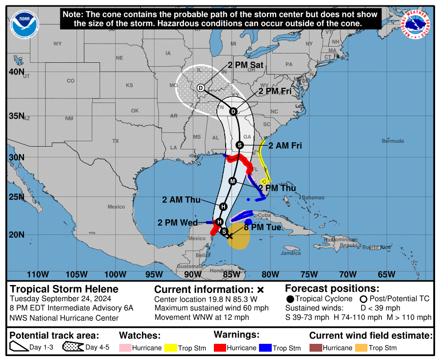
TROPICAL STORM HELENE – 2000 EDT – 9/24/24

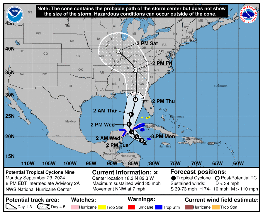
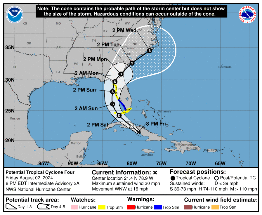
Potential Tropical Cyclone Nine was declared a “full fledged” tropical cyclone this morning in the 1100 EDT advisory, and went from straight from a potential tropical cyclone to a tropical storm.  The forecast track has changed very little since yesterday.  Right before the center enters the Gulf of Mexico on early Wednesday morning, Helene is forecast to intensify into a Category 1 hurricane.  Helene is forecast to continue this intensification, until it becomes a Category 3 hurricane, a major hurricane, on early Thursday morning before making landfall in the eastern Florida panhandle by Thursday evening near sunset. In other words, the energy available for this storm to tap is essentially “rocket fuel.”  Storms that enter the Gulf of Mexico often intensify very quickly, due to the high water temperature and low shear levels.  Helene once it reaches about 25 degrees in latitude is expect to “hit the accelerator” and increase in forward speed to around 20 mph, continuing this speed and increasing even slightly more after landfall, due to traveling in the area between a low pressure area to the west and high pressure to the east.

COASTAL WATCHES/WARNINGS AND FORECAST CONE FOR STORM CENTER

SUMMARY OF 2000 EST…0000 UTC…INFORMATION

——————————————————————————-
LOCATION…19.8N 85.3W
ABOUT 115 MI…185 KM ESE OF COZUMEL MEXICO
ABOUT 145 MI…235 KM S OF THE WESTERN TIP OF CUBA
MAXIMUM SUSTAINED WINDS…60 MPH…95 KM/H
PRESENT MOVEMENT…WNW OR 300 DEGREES AT 12 MPH…19 KM/H
MINIMUM CENTRAL PRESSURE…991 MB…29.26 INCHES

SUMMARY OF WATCHES AND WARNINGS IN EFFECT:

A Storm Surge Warning is in effect for…
* Indian Pass southward to Flamingo
* Tampa Bay
* Charlotte Harbor

A Hurricane Warning is in effect for…
* Anclote River to Mexico Beach, Florida
* Cabo Catoche to Tulum, Mexico

A Hurricane Watch is in effect for…
* Cuban province of Pinar del Rio
* Englewood to Anclote River, including Tampa Bay

A Tropical Storm Warning is in effect for…
* Dry Tortugas
* Lower and Middle Florida Keys west of the Channel 5 Bridge
* Flamingo to Anclote River, including Tampa Bay
* West of Mexico Beach to the Walton/Bay County Line
* Rio Lagartos to Cabo Catoche, Mexico
* Cuban provinces of Artemisa, Pinar del Rio, and the Isle of Youth

A Tropical Storm Watch is in effect for…
* Lake Okeechobee
* Palm Beach/Martin County Line northward to the Savannah River

A Storm Surge Warning means there is a danger of life-threatening inundation, from rising water moving inland from the coastline, during the next 36 hours in the indicated locations. For a depiction of areas at risk, please see the National Weather Service Storm Surge Watch/Warning Graphic, available at hurricanes.gov. This is a life-threatening situation. Persons located within these areas should take all necessary actions to protect life and property from rising water and the potential for other dangerous conditions. Promptly follow evacuation and other instructions from local officials.

A Hurricane Warning means that hurricane conditions are expected somewhere within the warning area. A warning is typically issued 36 hours before the anticipated first occurrence of tropical-storm-force winds, conditions that make outside preparations difficult or dangerous. Preparations to protect life and property should be rushed to completion.

A Tropical Storm Warning means that tropical storm conditions are expected somewhere within the warning area within the next 36 hours.

A Hurricane Watch means that hurricane conditions are possible within the watch area. A watch is typically issued 48 hours before the anticipated first occurrence of tropical-storm-force winds, conditions that make outside preparations difficult or dangerous.

A Tropical Storm Watch means that tropical storm conditions are possible within the watch area.

FORECAST DISCUSSION:

The following excerpt is from the Forecast Discussion issued at 1700 EDT today:

“Deep convection is gradually filling in within Helene’s circulation, and the well-defined center that formed earlier this morning is now obscured by cloudiness and showers. Data from NOAA buoy indicate that the central pressure has fallen to 995 mb, and the initial intensity is therefore estimated to be 45 kt. NOAA and the Air Force Reserve Hurricane Hunters will be investigating Helene this evening to provide more information about the storm’s intensity and structure.

With the center formation this morning, Helene has taken a short-term jog to the west-northwest (300/10 kt). The storm is expected to turn northwestward by tonight and then northward on Wednesday as high pressure over Florida shifts eastward, and a deep-layer trough digs southward over the Lower Mississippi Valley.  The NHC track forecast has been shifted westward during the first 24 hours to account for the recent motion, and Helene’s center could get very close to the northeastern coast of the Yucatan Peninsula Wednesday morning. After that time, however, the NHC track forecast is relatively unchanged from the previous prediction, except for being a little bit slower based on the latest guidance. Helene is expected to accelerate while it moves northward across the eastern Gulf of Mexico and approaches the Florida Gulf coast.

Warm sea surface temperatures, decreasing shear, and strong upper-level divergence are likely to foster Helene’s strengthening while it moves across the northwestern Caribbean Sea and eastern Gulf of Mexico. The statistical-dynamical SHIPS/LGEM models, as well as the regional hurricane models, continue to show Helene reaching major hurricane intensity while over the eastern Gulf of Mexico, and that continues to be shown in the NHC forecast. Helene could maintain that level of intensity until it reaches the Gulf coast of Florida.

Of equal importance to the forecast intensity is Helene’s forecast size. Helene’s forecast radii are at the 90th percentile of major hurricane size at similar latitudes, and therefore storm surge, wind, and rainfall impacts will likely extend well away from the center and outside the forecast cone, particularly on the east side. In addition, the fast forward speed while it crosses the coast will likely result in farther inland penetration of strong winds over parts of the southeastern United States after landfall.”

SITUATION AND ACTIONS:

Much has changed since yesterday as expected.  Here is the summary of the watches and warnings issued by the National Hurricane Center and the National Weather Service Office in Ruskin for the ARRL West Central Florida Section:

  • A Hurricane Warning is in effect for Coastal Pasco County.
  • A Tropical Storm Warning and a Hurricane Watch are both in effect for the following ARRL West Central Florida Section counties:  Inland Pasco, Pinellas, Coastal Hillsborough, Coastal Manatee, Coastal Sarasota.
  • A Tropical Storm Warning is in effect for for the following ARRL West Central Florida Section counties: Inland Pasco, Pinellas, Inland Hillsborough, Inland Manatee, Inland Sarasota, and Charlotte.
  • A Storm Surge Warning is in effect for the following ARRL West Central Florida Section counties:  Coastal Pasco, Pinellas, Coastal Hillsborough, Coastal Manatee, Coastal Sarasota, and Coastal Charlotte.
  • A Flood Watch is also in effect for all counties in the ARRL West Central Florida Section through Friday morning.

In anticipation of the arrival of what will become Hurricane Helene, Florida Governor Ron Desantis signed Executive Order 24-209, which amended his previous executive order, Executive ORder .  The number of Florida counties included in this declaration went from 41 to 61 counties.  All counties in the ARRL West Central Florida Section are now under a declared state of emergency.  For the full text of Executive Order 24-209 go to https://www.flgov.com/2024/09/24/memorandum-executive-order-number-24-209-emergency-management-amending-execuive-order-24-208-potential-tropical-cyclone-nine/.

Hillsborough County ARES/RACES has been fully activated and requested to staff the EOC and several shelters.  Bill Fetta N7CGG, Section Emergency Coordinator raised the ARES Alert Level to a Level 2, which is a partial activation, when one or more ARES groups in the ten counties of the ARR West Central Florida Section have been activated.ll ARES personnel are strongly encouraged to stay in communication with your respective ARES group leadership, as this may change in the next 12 to 24 hours.

The West Central Florida Skywarn Net will be activated on the NI4CE Analog and the NI4CE NXDN repeater system (talkgroup 1299), once severe weather begins to threaten the NWS Forecast Office Ruskin Coverage Warning Area, which should be sometime later on Wednesday.

All ARES, ACS, and CERT personnel should work to complete any last minute preparations in the next 24 hours, and do any last minute checks on their equipment in case they are requested to activate.

All ARES, ACS, and CERT personnel are encouraged to continue to check each advisory issued by the National Hurricane Center in Miami on Tropical Storm Helene and the Tropical Weather Outlook issued four times daily by the National Hurricane Center.

LATEST NATIONAL HURRICANE CENTER INFORMATION:

Public Advisories:   https://www.nhc.noaa.gov/text/refresh/MIATCPAT4+shtml/232347.shtml?

Forecast Advisory:  https://www.nhc.noaa.gov/text/refresh/MIATCMAT4+shtml/232051.shtml?

Forecast Discussion: https://www.nhc.noaa.gov/text/refresh/MIATCDAT4+shtml/232053.shtml?

Latest GOES Satellite Floater Images and Loop:  https://www.star.nesdis.noaa.gov/GOES/floater.php?stormid=AL092024#navLink

CONCLUSION

The next WCF SPECIAL BULLETIN will be tomorrow evening right after the 2000 EDT intermediate advisory on Tropical Storm Helene.

END OF SPECIAL BULLETIN

WCF SECTION SPECIAL BULLETIN #24-05 – 2000 EDT – 9/23/24

POTENTIAL TROPICAL CYCLONE NINE – 2000 EDT – 9/23/24

The area of disturbed weather that has been traveling across the southern Caribbean sea for about the last week, is now starting to get better organized.  Yesterday, it was designated Invest 97L.  As Invest 97L has been getting better organized, and in keeping with modern practice, the National Hurricane Center, declared Invest 97L to be Potential Tropical Cyclone Nine.  This system is expected to intensify into Tropical Storm Helene on Tuesday, and once it enters the Gulf of Mexico on Wednesday, rapidly intensify to a Category 1 Hurricane on Wednesday, and further intensify into a Category 3 Hurricane, a major hurricane, on Thursday before making landfall in the Florida panhandle.  This storm once it enters the Gulf of Mexico is expected to increase in forward speed as well running in between a low pressure area to the west and high pressure to the east.

COASTAL WATCHES/WARNINGS AND FORECAST CONE FOR STORM CENTER

SUMMARY OF 2000 EST…0000 UTC…INFORMATION

——————————————————————————-
LOCATION…18.3N 82.3W
ABOUT 100 MI…160 KM SW OF GRAND CAYMAN
ABOUT 300 MI…485 KM SE OF THE WESTERN TIP OF CUBA
MAXIMUM SUSTAINED WINDS…35 MPH…55 KM/H
PRESENT MOVEMENT…NNW OR 345 DEGREES AT 7 MPH…11 KM/H
MINIMUM CENTRAL PRESSURE…1002 MB…29.59 INCHES

SUMMARY OF WATCHES AND WARNINGS IN EFFECT:

A Hurricane Watch is in effect for…
* Cabo Catoche to Tulum, Mexico
* Cuban province of Pinar del Rio

A Tropical Storm Warning is in effect for…
* Grand Cayman
* Rio Lagartos to Tulum, Mexico
* Cuban provinces of Artemisa, and Pinar del Rio, and the Isle of
Youth

A Tropical Storm Watch is in effect for…
* Dry Tortugas
* Lower Keys south of the Seven Mile Bridge

A Tropical Storm Warning means that tropical storm conditions are expected somewhere within the warning area, in this case within the next 24 to 36 hours.

A Hurricane Watch means that hurricane conditions are possible within the watch area. A watch is typically issued 48 hours before the anticipated first occurrence of tropical-storm-force winds, conditions that make outside preparations difficult or dangerous.

A Tropical Storm Watch means that tropical storm conditions are possible within the watch area, generally within 48 hours.

FORECAST DISCUSSION:

The following excerpt is from the Forecast Discussion issued at 1700 EDT today:

Showers and thunderstorms associated with the disturbance are gradually becoming better organized this afternoon, although the convection is mostly confined to the eastern portion of the circulation. Scatterometer winds and aircraft data indicate the disturbance still lacks a well-defined center, with very light winds noted on the west side of the broad, elongated circulation. The scatterometer data did show stronger winds near the convection on the east side, and based on this along with the aircraft winds, the initial intensity is raised to 30 kt for this advisory.

The estimated initial motion is north-northwestward (345/6 kt), but the disturbance should turn more northwestward during the next day or so. The NHC forecast shows the center of the system passing between the Yucatan Peninsula and the western tip of Cuba late Tuesday night, then moving into the southern Gulf of Mexico on Wednesday. From there, the flow between a deep-layer trough over the central United States and a ridge over the western Atlantic should cause the system to accelerate northward to north-northeastward across the eastern Gulf of Mexico and toward the northeastern Gulf Coast and Florida Panhandle through Thursday. The track guidance is very tightly clustered on this solution, and the official NHC forecast is essentially an update of the previous one.

The moderate southwesterly shear over the disturbance is expected to diminish over the next day or two, which should allow the system to become better organized and consolidate over deep, warm waters in a very moist environment. Once the system develops an inner core, these conditions should allow it to significantly strengthen. The NHC forecast still calls for the system to become a hurricane on Wednesday, with continued intensification thereafter while it moves over the eastern Gulf of Mexico. Once again, the statistical RI guidance (SHIPS and DTOPS) show a 65-kt increase in 72 h is very likely, and the updated NHC forecast now explicitly shows the system reaching major hurricane intensity on Thursday. This intensity forecast still lies below the consensus aids, with the regional hurricane models and the GFS showing even more deepening.

Note that the system is expected to grow in size while it traverses the Gulf. Thus, the storm surge, wind, and rainfall impacts will extend well away from the center, particularly to the east of the system. In addition, the fast forward speed as it approaches the coast will likely result in farther inland penetration of gusty winds over parts of the southeastern United States after landfall.

SITUATION AND ACTIONS:

At the present time there are not any watches or warnings in effect for the ARRL West Central Florida Section.  However by this time tomorrow that situation will no doubt have changed and there will be watches or warnings in effect.

In anticipation of the arrival of what will become Hurricane Helene, Florida Governor Ron Desantis signed Executive Order 24-208, which is an emergency declaration for 41 Florida counties. For the full text of the declaration please go to https://www.flgov.com/2024/09/23/memorandum-executive-order-number-24-208-emergency-management-potential-tropical-cyclone-nine/ Included in this declaration are the following ARRL West Central Florida Section counties:  Pasco, Pinellas, Hillsborough, Manatee, Sarasota, and Charlotte Counties.  At the present time the inland ARRL West Central Florida Section counties of Desoto, Hardee, Highlands, and Polk Counties are not included.  However this could change if the path of the storm significantly changes.

Bill Fetta N7CGG, Section Emergency Coordinator raised the ARES Alert Level to a Level 3, which is a standby mode, in case of activation of any ARES groups in the ARRL West Central Florida Section.  At the present time no ARES groups have been requested to activate.  All ARES personnel are strongly encouraged to stay in communication with your respective ARES group leadership, as this may change in the next 12 to 24 hours.

The West Central Florida Skywarn Net will be activated on the NI4CE Analog and the NI4CE NXDN repeater system (talkgroup 1299), once severe weather begins to threaten the NWS Forecast Office Ruskin Coverage Warning Area.

All ARES, ACS, and CERT personnel should work to complete any last minute preparations and do any last minute checks on their equipment in case they are requested to activate.

All ARES, ACS, and CERT personnel are encouraged to continue to check each advisory issued by the National Hurricane Center in Miami on Potential Tropical Cyclone Nine and the Tropical Weather Outlook issued four times daily by the National Hurricane Center.

LATEST NATIONAL HURRICANE CENTER INFORMATION:

Public Advisories:   https://www.nhc.noaa.gov/text/refresh/MIATCPAT4+shtml/232347.shtml?

Forecast Advisory:  https://www.nhc.noaa.gov/text/refresh/MIATCMAT4+shtml/232051.shtml?

Forecast Discussion: https://www.nhc.noaa.gov/text/refresh/MIATCDAT4+shtml/232053.shtml?

Latest GOES Satellite Floater Images and Loop:  https://www.star.nesdis.noaa.gov/GOES/floater.php?stormid=AL092024#navLink

CONCLUSION

The next WCF SPECIAL BULLETIN will be tomorrow evening right after the 2000 EDT intermediate advisory on Potential Tropical Cyclone Nine.

END OF SPECIAL BULLETIN

WCF SECTION PRESS RELEASE #24-08

SECTION ARES NET AND EAGLE NET CANCELLED FOR THIS EVENING DUE TO TROPICAL STORM DEBBY AFTERMATH

Due to recovery efforts of our amateur radio operators in the ares, the ARRL West Central Florida Section ARES and Information Net scheduled for Monday 8/05/24 at 1930 EDT on the NI4CE Analog Repeater System is cancelled.  The ARRL West Central Florida Section ARES and Information Net will resume normal operation at 1930 EDT on Monday 8/12/24.

Due to the aftermath of Tropical Storm Debby, the Eagle Net, the NTS Traffic Net for the ARRL West Central Florida Section, scheduled for Monday 8/05/24 at 2030 is also cancelled.  The Eagle Net will resume normal operation tomorrow, Tuesday 8/06/24 at 2030 EDT.

(Note: The Eagle Net cancellation was added to this original bulletin after its publication.)

END OF PRESS RELEASE


WCF SECTION SPECIAL BULLETIN #24-04 – 1800 EDT – 8/05/24

TROPICAL STORM DEBBY – 1800 EDT – 8/05/24 – FINAL

Tropical Storm Debby, became Hurricane Debby late last night and made landfall around 0700 at Steinahatchee, about 20 miles down the west coast from Keaton Beach, which is where Hurricane Idalia made landfall almost one year ago. Debby, now moving due north, will turn slightly to the northeast before making landfall tomorrow around midday in the Taylor and Jefferson County area.  Debby is now projected to enter Georgia later this evening and take a very slow path either out to the Atlantic briefly before making a second landfall in South Carolina or wander along the Georgia coast to South Carolina.  Finally late in the week the Westerlies will begin to capture her and take her eventually out into the North Atlantic.

COASTAL WATCHES/WARNINGS AND FORECAST CONE FOR STORM CENTER

SUMMARY OF 1700 EST…2100 UTC…INFORMATION

——————————————————————————-
LOCATION…30.5N 82.9W
ABOUT 30 MI…50 KM SE OF VALDOSTA GEORGIA
MAXIMUM SUSTAINED WINDS…50 MPH…85 KM/H
PRESENT MOVEMENT…NE OR 35 DEGREES AT 6 MPH…9 KM/H
MINIMUM CENTRAL PRESSURE…994 MB…29.36 INCHES

SUMMARY OF WATCHES AND WARNINGS IN EFFECT:

A Storm Surge Warning is in effect for…
* Georgia and South Carolina coast from the Mouth of the St. Mary’s River to South Santee River South Carolina

A Storm Surge Watch is in effect for…
* South Carolina and North Carolina coast from north of South Santee River to Cape Fear, North Carolina

A Tropical Storm Warning is in effect for…
* St. Augustine, Florida to South Santee River, South Carolina

A Tropical Storm Watch is in effect for…
* North of South Santee River, South Carolina to Cape Fear, North Carolina

A Tropical Storm Warning means that tropical storm conditions are expected somewhere within the warning area within 36 hours.

A Tropical Storm Watch means that tropical storm conditions are possible within the watch area, generally within 48 hours.

A Storm Surge Warning means there is a danger of life-threatening inundation, from rising water moving inland from the coastline. For a depiction of areas at risk, please see the National Weather Service Storm Surge Watch/Warning Graphic, available at hurricanes.gov.

This is a life-threatening situation. Persons located within these areas should take all necessary actions to protect life and property from rising water and the potential for other dangerous conditions.  Promptly follow evacuation and other instructions from local officials.

A Storm Surge Watch means there is a possibility of life-threatening inundation, from rising water moving inland from the coastline, in the indicated locations during the next 48 hours.  For a depiction of areas at risk, please see the National Weather Service Storm Surge Watch/Warning Graphic, available at hurricanes.gov.

Interests elsewhere along the southeastern coast of the United States should monitor the progress of this system. Additional watches and warnings will likely be required later today.

For storm information specific to your area, including possible inland watches and warnings, please monitor products issued by your local National Weather Service forecast office.

FORECAST DISCUSSION:

The following excerpt is from the Forecast Discussion issued at 1700 EDT today:

Debby continues to move over land, and based on surface synoptic and radar observations the center is estimated to be near the Florida/Georgia border. Assuming a continued weakening since landfall, the intensity estimate has been reduced to 45 kt, which is reasonably consistent with the latest WSR-88D radar velocities aloft.

Debby continues to move through a weakness in the subtropical high, and the forward motion has slowed to about 035/6 kt. The cyclone is expected to turn eastward, while moving quite slowly, in a region of weak steering currents for the next couple of days. This
motion should bring the center of the system back over water by late Tuesday. In around 72 hours, a mid-level ridge to the east of Debby is forecast to build somewhat, and as a result, the center should move inland over South Carolina and turn northward and northeastward over the eastern U.S. for the remainder of theforecast period. The NHC track forecast is similar to the previous one and is in good agreement with the corrected model consensus, HCCA, guidance.

The tropical cyclone should continue to weaken while it moves over land for the next day or so. By late Tuesday, assuming the center of the system moves back over water, some re-intensification is forecast. The NHC forecast continues to show only modest restrengthening due to the uncertainties, although this may be conservative.

Given the sluggish forward motion of Debby, extremely large amounts of rainfall over the Southeastern U.S. is anticipated.

SITUATION AND ACTIONS:

All Tropical Storm Watches and Warning for the ARRL West Central Florida Section were dropped this afternoon with the 1700 EDT advisory.  All Storm Surge Watches and Warnings were discontinued earlier today.  The ARRL West Central Florida Section continues under a Flood Watch until 2000 EDT this evening.

With the imminent demobilization of Hillsborough County ARES/RACES, effective at 1700 EDT, the ARES alert level for the ARRL West Central Florida Section will return to a no activation status, effective at 1800 EDT.  The ARRL West Central Florida Section extends its sincere thanks to all amateur radio operators who were deployed, ready to be deployed, and supported the West Central Florida SKYWARN Net that was in session for the past few days and today.

With amateur radio operators busy with their own recovery actions, the ARRL West Central Florida Section ARES Net scheduled for Monday 8/05/24 at 1930 EDT on the NI4CE Analog Repeater System is cancelled.  The ARRL West Central Florida Section ARES Net will resume operation Monday 8/12/24.

All ARES, ACS, and CERT personnel are encouraged to continue to check each advisory issued by the National Hurricane Center in Miami on Tropical Storm Debby and the Tropical Weather Outlook issued four times daily by the National Hurricane Center.

LATEST NATIONAL HURRICANE CENTER INFORMATION:

Public Advisories:  https://www.nhc.noaa.gov/text/refresh/MIATCPAT4+shtml/030249.shtml?

Forecast Advisory:  https://www.nhc.noaa.gov/text/refresh/MIATCMAT4+shtml/030249.shtml?

Forecast Discussion:  https://www.nhc.noaa.gov/text/refresh/MIATCDAT4+shtml/030250.shtml?

Latest GOES Satellite Floater Images and Loop:  https://www.star.nesdis.noaa.gov/GOES/floater.php?stormid=AL042024#navLink

CONCLUSION

This is the last WCF SECTION SPECIAL BULLETIN on Tropical Storm Debby unless it becomes a threat to the Section once again.

END OF SPECIAL BULLETIN

WCF SECTION PRESS RELEASE #24-07

EAGLE NET CANCELLED DUE TO TROPICAL STORM DEBBY

Being the West Central Florida SKYWARN Net is currently running on the NI4CE Analog Repeater System due to the proximity of Tropical Storm Debby, the Eagle Net, the NTS traffic net for the ARRL West Central Florida Section will be cancelled for Sunday 8/04/24.  The Eagle Net will resume normal operation on Monday 8/05/24 at 2030 EDT.

END OF PRESS RELEASE

WCF SECTION SPECIAL BULLETIN #24-03 – 1900 EDT – 8/04/24

TROPICAL STORM DEBBY – 1900 EDT – 8/04/24

Tropical Storm Debby, which is approaching hurricane strength, is now due west of Hillsborough and Pinellas Counties.  Over a good portion of the day there have been many tornado warnings and severe thunderstorm warnings in areas hit by feeder bands.  Debby, now moving due north, will turn slightly to the northeast before making landfall tomorrow around midday in the Taylor and Jefferson County area.  Debby is then projected to exit the east coast of the United States either sooner or later depending upon which path it finally takes.  Its current projected path, until landfall, is reminiscent in some ways of the path taken by Hurricane Idalia one year ago.

COASTAL WATCHES/WARNINGS AND FORECAST CONE FOR STORM CENTER

SUMMARY OF 1900 EST…2300 UTC…INFORMATION

——————————————————————————-
LOCATION…27.7N 84.4W
ABOUT 120 MI…190 KM W OF TAMPA FLORIDA
ABOUT 125 MI…200 KM SW OF CEDAR KEY FLORIDA
MAXIMUM SUSTAINED WINDS…65 MPH…100 KM/H
PRESENT MOVEMENT…N OR 360 DEGREES AT 12 MPH…19 KM/H
MINIMUM CENTRAL PRESSURE…992 MB…29.30 INCHES

SUMMARY OF WATCHES AND WARNINGS IN EFFECT:

A Storm Surge Warning is in effect for…
* Florida coast from Aripeka northward to Indian Pass

A Storm Surge Watch is in effect for…
* Florida coast from Bonita Beach northward to Aripeka, including Tampa Bay and Charlotte Harbor

A Hurricane Warning is in effect for…
* Florida coast from the Suwannee River to the Ochlockonee River

A Hurricane Watch is in effect for…
* Florida coast west of the Ochlockonee River to Indian Pass
* Florida coast east of the Suwannee River to Yankeetown

A Tropical Storm Warning is in effect for…
* The Florida Keys west of the Seven Mile Bridge including the Dry Tortugas
* Florida coast south of the Suwannee River to East Cape Sable

A Tropical Storm Watch is in effect for…
* The Florida Keys north of the Seven Mile Bridge to the Channel 5 Bridge
* Florida coast west of Indian Pass to Mexico Beach

A Hurricane Warning means that hurricane conditions are expected somewhere within the warning area. A warning is typically issued 36 hours before the anticipated first occurrence of tropical-storm-force winds, conditions that make outside preparations difficult or dangerous. Preparations to protect life and property should be rushed to completion.

A Tropical Storm Warning means that tropical storm conditions are expected somewhere within the warning area within 36 hours.

A Hurricane Watch means that hurricane conditions are possible within the watch area. A watch is typically issued 48 hours before the anticipated first occurrence of tropical-storm-force winds, conditions that make outside preparations difficult or dangerous.

A Tropical Storm Watch means that tropical storm conditions are possible within the watch area, generally within 48 hours.

A Storm Surge Warning means there is a danger of life-threatening inundation, from rising water moving inland from the coastline, during the next 36 hours in the indicated locations. For a depiction of areas at risk, please see the National Weather Service Storm Surge Watch/Warning Graphic, available at hurricanes.gov.

This is a life-threatening situation. Persons located within these areas should take all necessary actions to protect life and property from rising water and the potential for other dangerous conditions. Promptly follow evacuation and other instructions from local officials.

A Storm Surge Watch means there is a possibility of life-threatening inundation, from rising water moving inland from the coastline, in the indicated locations during the next 48 hours. For a depiction of areas at risk, please see the National Weather Service Storm Surge Watch/Warning Graphic, available at hurricanes.gov.

FORECAST DISCUSSION:

The following excerpt is from the Forecast Discussion issued at 1700 EDT today:

Debby’s cloud pattern continues to show increasing organization on satellite images although there is limited deep convection over the southwest quadrant of the circulation. The upper-level anticyclonic outflow pattern is well-defined. The latest Air Force Hurricane Hunter aircraft observations indicated that the central pressure hadn’t changed much and the wind data from the aircraft continued to support an intensity of near 55 kt. WSR-88D radar imagery shows that an eyewall may be trying to close off, and another Hurricane Hunter aircraft will be investigating Debby in a few hours to assess the strength of the cyclone.

The cyclone has turned toward the north and is now moving at around 360/10 kt. Debby should continue to move through a break in the subtropical ridge due to a trough over the eastern United States for the next day or so, and this motion should bring the center of the system to the northeast Gulf of Mexico coast around midday tomorrow. Thereafter, the trough moves eastward, leaving Debby in weak steering currents for a few days. The track guidance shows decreasing forward speed and a turn to the east in 24-48 hours.  Some of the track models show the cyclone moving temporarily over the Atlantic in the 72-hour time frame, and so does the official forecast.

Debby will continue to move over waters of high heat content and remain in an environment of low vertical wind shear into Monday morning. Some dry air intrusion over the southwestern portion of the circulation may have temporarily interrupted the intensification process. However, given the favorable oceanic and shear conditions, significant strengthening is expected before landfall.  Rapid intensification is especially likely if Debby acquires a well-defined inner core. The official intensity forecast is at the high end of the model guidance. Although weakening will occur after landfall, the longer-term strength of the system is largely dependent on how long it remains over land. Currently the official forecast shows some re-intensification with Debby moving into the Atlantic, but how much the system will restrengthen is highly uncertain.

SITUATION AND ACTIONS:

Basically there have not been any changes to tropical storm watches or warnings since yesterday.  A Tropical Storm Warning is in effect for the following ARRL West Central Florida Section counties:  Coastal Charlotte, Sarasota, Manatee, Hillsborough, Manatee, Pasco, and Pinellas Counties.  A Tropical Storm Watch remains in effect for the following ARRL West Central Florida Section counties:  Inland Charlotte, Polk, Desoto, and Hardee Counties.  A Storm Surge Watch is in effect for the coastal portions of Charlotte, Sarasota, Manatee, Hillsborough, Pinellas, and Pasco Counties.  Highlands County is the only county in the ARRL West Central Florida Section that does not have any tropical watches or warnings at the present time.

A Tornado Watch that was set to expire at press time, has been extended until 0600 EDT on Monday 8/05/24, for the following ARRL West Central Florida Section counties:  Hardee, Hillsborough, Manatee, Pasco, Pinellas, and Polk Counties.  The Tornado Watch for the other ARRL West Central Florida Section has been allowed to expire.  Due to continuous rainfall, a Flood Watch has been extended and is now in effect for all of the ARRL West Central Florida Section until 2000 EDT tomorrow evening, Monday 8/05/24.

West Central Florida SKYWARN is active on the NI4CE Analog Repeater System and NI4CE NXDN Repeater System on Talkgroup 1299.  Due to continued SKYWARN activity, the Eagle Net scheduled for 2030 EDT on Sunday 8/04/24 is CANCELLED.  The net will return to normal operation tomorrow Monday 8/05/24 at 2030 EDT.

At 2000, the ARRL West Central Florida Section ARES Alert Level remains at a Level 3 Alert.  A Level 3 Alert indicates that all ARES groups are on standby in case their services are requested by their served agencies.  The only ARES group that has been deployed is Hillsborough County ARES/RACES at the present time.  At the present time, there have not been any other requests for service from any of the primary served agencies that ARES serves in the ARRL West Central Florida Section.  The Sarasota Agricultural Recovery Group (SARG) has been requested to standby in case of need activation as well.

All ARES, ACS, and CERT personnel are encouraged to continue to check each advisory issued by the National Hurricane Center in Miami on Tropical Storm Debby and the Tropical Weather Outlook issued four times daily by the National Hurricane Center.  Also SKYWARN spotters are encouraged to remain alert and ready to report to the National Weather Service Office in Ruskin any weather that meets the severe weather criteria.

LATEST NATIONAL HURRICANE CENTER INFORMATION:

Public Advisories:  https://www.nhc.noaa.gov/text/refresh/MIATCPAT4+shtml/030249.shtml?

Forecast Advisory:  https://www.nhc.noaa.gov/text/refresh/MIATCMAT4+shtml/030249.shtml?

Forecast Discussion:  https://www.nhc.noaa.gov/text/refresh/MIATCDAT4+shtml/030250.shtml?

Latest GOES Satellite Floater Images and Loop:  https://www.star.nesdis.noaa.gov/GOES/floater.php?stormid=AL042024#navLink

CONCLUSION

The next WCF SECTION SPECIAL BULLETIN will be issued tomorrow following the 1700 EDT advisory, unless conditions warrant a sooner release.

END OF SPECIAL BULLETIN

WCF SECTION SPECIAL BULLETIN #24-02 – 2000 EDT – 8/03/24

TROPICAL STORM DEBBY – 2000 EDT – 8/03/24

Much has changed since the last bulletin.  Potential Tropical Cyclone Four became Tropical Depression Four last evening at 2300 EDT, and Tropical Storm Debby at 1700 EDT today.  Debby most likely has finally made its turn to the northwest, crossed over Cuba and is now in the southeastern Gulf of Mexico and is making its long journey to the Florida Panhandle.  Its current projected path is reminiscent in some ways of the path taken by Hurricane Idalia one year ago.

COASTAL WATCHES/WARNINGS AND FORECAST CONE FOR STORM CENTER

SUMMARY OF 2000 EST…0000 UTC…INFORMATION

——————————————————————————-
LOCATION…24.1N 83.3W
ABOUT 100 MI…160 KM WSW OF KEY WEST FLORIDA
ABOUT 270 MI…435 KM S OF TAMPA FLORIDA
MAXIMUM SUSTAINED WINDS…40 MPH…65 KM/H
PRESENT MOVEMENT…NW OR 315 DEGREES AT 14 MPH…22 KM/H
MINIMUM CENTRAL PRESSURE…1005 MB…29.68 INCHES

SUMMARY OF WATCHES AND WARNINGS IN EFFECT:

SUMMARY OF WATCHES AND WARNINGS IN EFFECT:

A Storm Surge Warning is in effect for…
* Florida coast from Aripeka northward to Indian Pass

A Storm Surge Watch is in effect for…
* Florida coast from Bonita Beach northward to Aripeka, including Tampa Bay and Charlotte Harbor

A Hurricane Warning is in effect for…
* Florida coast from the Suwannee River to the Ochlockonee River

A Hurricane Watch is in effect for…
* Florida coast west of the Ochlockonee River to Indian Pass
* Florida coast east of the Suwannee River to Yankeetown

A Tropical Storm Warning is in effect for…
* The Florida Keys west of the Seven Mile Bridge including the Dry Tortugas
* Florida coast south of the Suwannee River to East Cape Sable

A Tropical Storm Watch is in effect for…
* The Florida Keys north of the Seven Mile Bridge to the Channel 5 Bridge
* Florida coast west of Indian Pass to Mexico Beach

A Hurricane Warning means that hurricane conditions are expected somewhere within the warning area. A warning is typically issued 36 hours before the anticipated first occurrence of tropical-storm-force winds, conditions that make outside preparations difficult or dangerous. Preparations to protect life and property should be rushed to completion.

A Tropical Storm Warning means that tropical storm conditions are expected somewhere within the warning area within 36 hours.

A Hurricane Watch means that hurricane conditions are possible within the watch area. A watch is typically issued 48 hours before the anticipated first occurrence of tropical-storm-force winds, conditions that make outside preparations difficult or dangerous.

A Tropical Storm Watch means that tropical storm conditions are possible within the watch area, generally within 48 hours.

A Storm Surge Warning means there is a danger of life-threatening inundation, from rising water moving inland from the coastline, during the next 36 hours in the indicated locations. For a depiction of areas at risk, please see the National Weather Service Storm Surge Watch/Warning Graphic, available at hurricanes.gov.

This is a life-threatening situation. Persons located within these areas should take all necessary actions to protect life and property from rising water and the potential for other dangerous conditions. Promptly follow evacuation and other instructions from local officials.

A Storm Surge Watch means there is a possibility of life-threatening inundation, from rising water moving inland from the coastline, in the indicated locations during the next 48 hours. For a depiction of areas at risk, please see the National Weather Service Storm Surge Watch/Warning Graphic, available at hurricanes.gov.
.

FORECAST DISCUSSION:

The following excerpt is from the Forecast Discussion issued at 1700 EDT today:

The tropical cyclone has become better organized since the last advisory, with the circulation center becoming better defined over the southeastern Gulf of Mexico and areas of outer convective banding to the north and south of the central region. A combination of earlier scatterometer data, surface observations in the Florida Keys, and ship reports in the Straits of Florida shows an area of 30-35 kt winds located about 120 n mi from the center in the eastern semicircle. Based on this information, Tropical Depression Four is upgraded to Tropical Storm Debby.

The initial motion is now northwest or 310/13 kt. A large mid- to upper-level trough over the central United States is creating a break in the subtropical ridge, and Debby is expected to turn northward into this break in about 24 h. This should be followed
by a gradual turn toward the northeast at a slower forward speed through 60 h. This motion should bring the center near or over the northern Gulf coast in roughly 48 h. After landfall, weakening steering currents should cause the cyclone to slow down while it
moves northeastward or eastward over parts of northern Florida and Georgia. The uncertainty in the forecast increases significantly after 60 h as the cyclone interacts with a portion of the U.S. trough. The latest GFS and ECMWF models show a slow eastward motion into the Atlantic, followed by a turn toward the north or northwest that brings the center back inland. On the other hand, the Canadian model is still forecasting Debby to move slowly northeastward across the southeastern states and does not bring it over the Atlantic. This portion of the new forecast track continues to show a slow motion and leans toward the GFS/ECMWF solutions.

Conditions are favorable for strengthening over the Gulf of Mexico with warm sea surface temperatures and light shear. Intensification is likely to be slow during the first 12-24 h, then proceed at a faster rate after the cyclone develops an organized inner core. The new intensity forecast calls for a peak intensity of 65 kt at landfall on the Gulf coast of Florida in best agreement with the HWRF model. Weakening is forecast after landfall while the system moves over the southeastern United States. Beyond 72 h, the intensity forecast remains quite uncertain due to the possibility of land interaction and how much interaction will occur with the aforementioned mid-latitude trough

SITUATION AND ACTIONS:

Since yesterday the tropical storm watches were upgraded to tropical storm warnings for the coastal counties.  A Tropical Storm Warning is in effect for the following ARRL West Central Florida Section counties:  Charlotte, Hillsborough, Manatee, Pasco, and Pinellas Counties.  A Tropical Storm Watch remains in effect for the following ARRL West Central Florida Section counties:  Polk, Desoto, and Hardee Counties.  A Storm Surge Watch is in effect for the coastal portions of Charlotte, Sarasota, Manatee, Hillsborough, Pinellas, and Pasco Counties.  Highlands County is the only county in the ARRL West Central Florida Section that does not have any watch or warnings at the present time.

Due to the threat from excessive rainfall, A Flood Watch is in effect for the following ARRL West Central Florida Section counties: Charlotte, Sarasota, Manatee, Hillsborough, Pinellas, and Pasco Counties.

At 2000, the ARRL West Central Florida Section ARES Alert Level remains at a Level 3 Alert.  A Level 3 Alert indicates that all ARES groups are on standby in case their services are requested by their served agencies.  The only ARES group that has been deployed is Hillsborough County ARES/RACES at the present time.  At the present time, there have not been any other requests for service from any of the primary served agencies that ARES serves in the ARRL West Central Florida Section.

All ARES, ACS, and CERT personnel are encouraged to continue to check each advisory issued by the National Hurricane Center in Miami on Tropical Storm Debby and the Tropical Weather Outlook issued four times daily by the National Hurricane Center.  Also SKYWARN spotters are encouraged to remain alert and ready to report to the National Weather Service Office in Ruskin any weather that meets the severe weather criteria.

LATEST NATIONAL HURRICANE CENTER INFORMATION:

Public Advisories:  https://www.nhc.noaa.gov/text/refresh/MIATCPAT4+shtml/030249.shtml?

Forecast Advisory:  https://www.nhc.noaa.gov/text/refresh/MIATCMAT4+shtml/030249.shtml?

Forecast Discussion:  https://www.nhc.noaa.gov/text/refresh/MIATCDAT4+shtml/030250.shtml?

Latest GOES Satellite Floater Images and Loop:  https://www.star.nesdis.noaa.gov/GOES/floater.php?stormid=AL042024#navLink

CONCLUSION

The next WCF SECTION SPECIAL BULLETIN will be issued tomorrow following the 1700 EDT advisory, unless conditions warrant a sooner release.

END OF SPECIAL BULLETIN

WCF SECTION SPECIAL BULLETIN #24-01 – 2100 EDT – 8/02/24

POTENTIAL TROPICAL CYCLONE 4 – 2100 EST – 8/02/24

Invest 97L, which had been moving closer and closer to the southeastern United States for several days was finally declared a Potential Tropical Cyclone Four, on Thursday August 1, 2024.  If Potential Tropical Cyclone Four becomes a tropical storm, it will be called Tropical Storm Debby.  Its current projected path is reminiscent in some ways of the path taken by Hurricane Idalia one year ago.

COASTAL WATCHES/WARNINGS AND FORECAST CONE FOR STORM CENTER

SUMMARY OF 2000 EST…0000 UTC…INFORMATION

——————————————————————————-
LOCATION…21.4N 78.9W
ABOUT 70 MI…110 KM W OF CAMAGUEY CUBA
ABOUT 285 MI…460 KM SE OF KEY WEST FLORIDA
MAXIMUM SUSTAINED WINDS…30 MPH…45 KM/H
PRESENT MOVEMENT…WNW OR 290 DEGREES AT 16 MPH…26 KM/H
MINIMUM CENTRAL PRESSURE…1010 MB…29.82 INCHES

SUMMARY OF WATCHES AND WARNINGS IN EFFECT:

A Storm Surge Warning is in effect for…
* St. Catherine’s Sound Georgia to South Santee River South Carolina

A Tropical Storm Warning is in effect for…
* West coast of the Florida peninsula from East Cape Sable to Boca Grande

A Tropical Storm Watch is in effect for…
* The Florida Keys south of the Card Sound Bridge including the Dry Tortugas
* The southern coast of the Florida peninsula east of East Cape Sable to the Card Sound Bridge
* The west coast of the Florida peninsula north of Boca Grande to the mouth of the Suwannee River

A Storm Surge Watch is in effect for…
* Bonita Beach northward to the mouth of the Suwannee River, including Tampa Bay and Charlotte Harbor

A Tropical Storm Warning means that tropical storm conditions are expected somewhere within the warning area within 36 hours.

A Tropical Storm Watch means that tropical storm conditions are possible within the watch area, generally within 48 hours.

A Storm Surge Watch means there is a possibility of life-threatening inundation, from rising water moving inland from the coastline, in the indicated locations during the next 48 hours. For a depiction of areas at risk, please see the National Weather Service Storm Surge Watch/Warning Graphic, available at hurricanes.gov.

FORECAST DISCUSSION:

The following excerpt is from the Forecast Discussion issued at 1700 EDT today:

Convection and vorticity associated with the tropical wave, now over central Cuba, have both increased a little this afternoon. However, the circulation is still not well-defined, and the convection is not yet well enough organized to consider the system to be a tropical depression. So, the system remains a potential tropical cyclone at this time. A NOAA Hurricane Hunter is currently investigating the northern side of the wave, and a combination of its dropsondes and earlier scatterometer data suggest that the maximum winds remain near 25 kt.

The poorly-defined center has moved more westward since the previous advisory. However the overall motion remains about 290/14 kt.  A turn toward the northwest and north is expected during the next couple of days as the system moves into a break in the subtropicalridge caused by a mid-latitude trough over the Ohio Valley. This should be followed by recurvature into the westerlies after 48-60 h.  On the forecast track, the system is expected to move into the Straits of Florida and the southeastern Gulf of Mexico on Saturday, followed by a motion near the west coast of Florida Saturday night and Sunday. After that time, the system should cross the northern Florida peninsula and move over the Atlantic near or offshore of the southeastern coast of the United States. While the track guidance generally agrees with this scenario, there are a couple of issues. First, the GFS moves the system much faster northeastward, and by 72 h it is forecasting the center to be off of the South Carolina coast. Meanwhile, the ECMWF and UKMET still have the center over the Gulf of Mexico. Second, due to the track being almost parallel to both the west coast of the Florida peninsula and the southeastern U. S. coast, small changes in the track could cause large differences in potential landfalls and which land areas receive the strongest impacts.

There is little change in the intensity forecast philosophy from the previous advisory. Slow development is possible while the system is over Cuba, and the system is likely to become a tropical depression soon after it moves offshore on Saturday. The environment over the Gulf of Mexico is quite favorable for strengthening with light shear and very warm sea-surface temperatures, so subsequent steady strengthening is expected. The two biggest uncertainties in the intensity forecast are how long the system will remain offshore of Florida and how long it will take to consolidate. The system is likely to weaken as it crosses Florida, with re-intensification likely over the Atlantic after 72 h.

SITUATION AND ACTIONS:

As of 2000 EDT, A Tropical Storm Watch is in effect for the following ARRL West Central Florida Section:  Charlotte, Desoto, Hardee, Hillsborough, Manatee, Pasco, Pinellas, and Polk Counties.  A Storm Surge Watch is in effect for the coastal portions of Charlotte, Sarasota, Manatee, Hillsborough, Pinellas, and Pasco Counties.  Note that Highlands County is the only county in the ARRL West Central Florida Section that does not have any watch or warnings at the present time.

At 2000, the ARRL West Central Florida Section ARES Alert Level was raised to a Level 3 Alert.  A Level 3 Alert indicates that all ARES groups are on standby in case their services are requested by their served agencies.  At the present time, there have not been any requests for service from any of the primary served agencies that ARES serves in the ARRL West Central Florida Section.

All ARES, ACS, and CERT personnel are encouraged to continue to check each advisory issued by the National Hurricane Center in Miami on Potential Tropical Cyclone Four and the Tropical Weather Outlook issued four times daily by the National Hurricane Center.

LATEST NATIONAL HURRICANE CENTER INFORMATION:

Public Advisories:  https://www.nhc.noaa.gov/text/refresh/MIATCPAT4+shtml/030249.shtml?

Forecast Advisory:  https://www.nhc.noaa.gov/text/refresh/MIATCMAT4+shtml/030249.shtml?

Forecast Discussion:  https://www.nhc.noaa.gov/text/refresh/MIATCDAT4+shtml/030250.shtml?

Latest GOES Satellite Floater Images and Loop:  https://www.star.nesdis.noaa.gov/GOES/floater.php?stormid=AL042024#navLink

CONCLUSION

The next WCF SECTION SPECIAL BULLETIN will be issued tomorrow following the 1700 EDT advisory, unless conditions warrant a sooner release.

END OF SPECIAL BULLETIN

WCF SECTION PRESS RELEASE #24-06

SECTION NET CANCELLATIONS FOR THE INDEPENDENCE DAY HOLIDAY AND WEEKEND

In observance of Independence Day of Thursday July 4, 2024, the
following Section Nets will be cancelled:
The ARRL West Central Florida Section Technical Net scheduled for
Thursday July 4, 2024 at 2100 EDT on the NI4CE Repeater System will be cancelled. The net will resume normal operation on Thursday July 11, 2024.
The ARRL West Central Section ARES and Information scheduled for
Saturday July 6, 2024 at 0730 EDT on 3940 KHz is cancelled. The ARRL West Central Florida Section ARES and Information Net will resume normal operation on Saturday July 13, 2024.
All other Section Nets will operate as scheduled. The ARRL West Central
Florida Section wishes everyone a Happy and safe Independence Day
holiday and weekend.

END OF PRESS RELEASE

WCF SECTION PRESS RELEASE #24-05

24TH ANNUAL FIELD DAY CARAVAN AND SPECIAL EDITION OF THE EAGLE NET FOR ARRL FIELD DAY.

In keeping with tradition, once again this year our Section Manager and some of the Assistant Section Managers will be doing the 24th Annual West Central Florida Section Field Day Caravan.  The following are participating in the caravan:  Mike Douglas W4MDD our Section Managers and Assistant Section Managers Russ Delaney N4RTD and Darrell Davis KT4WX.  They will be split into two teams.  For areas of coverage and APRS tracking information you may go to the West Central Florida Section Field Day Caravan page at http://arrlwcf.org/wcf-special-events/west-central-florida-section-field-day-caravan/.

For those wishing to send NTS Radiograms to our Section Manager, Section Emergency Coordinator, or anyone else for bonus points, there will be a special extended edition of the Eagle Net on Saturday June 22, 2024 at 2030 Eastern Time.  Dave Rockwell W4PXE, our Section Traffic Manager, will be Net Control of this special edition and will be NCS from W4ACS, the station at the Pinellas County Emergency Operations Center.

Also on the West Central Florida Section Field Day Caravan page there are instructions on what should be included in an NTS Radiogram to our Section Manager or Section Emergency Coordinator and suggested way in which clubs, groups, or individuals may send that NTS Radiogram as well.

The ARRL West Central Florida Section wishes everyone a successful 2024 ARRL Field Day.

END OF PRESS RELEASE

1 2 3 4 51