WCF SECTION SPECIAL BULLETIN #24-09 – 2000 EDT – 9/27/24 – FINAL
POST TROPICAL CYCLONE HELENE – 2000 EDT – 9/27/24 – FINAL
Hurricane Helene made landfall a Category 4 Hurricane at approximately 2310 EDT yesterday, just east of the mouth of the Aucilla River, which is about 10 miles west-southwest of Perry, in Taylor County. As expected by this morning the center of Helene had moved into south central Georgia. Helene has now transitioned into a extratropical area of low pressure that is centered over central Kentucky Conditions will continue to improve and tomorrow’s weather will return to a normal late summertime pattern.
COASTAL WATCHES/WARNINGS AND FORECAST CONE FOR STORM CENTER
SUMMARY OF 1700 EST…0000 UTC…INFORMATION
——————————————————————————-
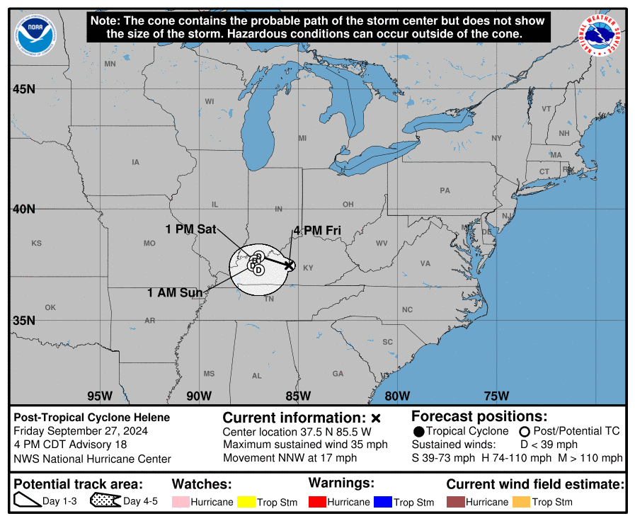
LOCATION…37.5N 85.5W
ABOUT 50 MI…80 KM SSE OF LOUISVILLE KENTUCKY
MAXIMUM SUSTAINED WINDS…35 MPH…55 KM/H
PRESENT MOVEMENT…NNW OR 330 DEGREES AT 17 MPH…28 KM/H
MINIMUM CENTRAL PRESSURE…984 MB…29.06 INCHES
SUMMARY OF WATCHES AND WARNINGS IN EFFECT:
There are no coastal watches or warnings in effect.
For storm information specific to your area, please monitor
products issued by your local National Weather Service forecast
office.
FORECAST DISCUSSION:
The following excerpt is from the Forecast Discussion issued at 1700 EDT today:
Helene has been producing catastrophic flooding over portions of the southeast U.S. and southern Appalachians, and the associated heavy rains are shifting westward into the Ohio and Tennessee Valleys. Satellite images and surface observations indicate that
Helene has completed extratropical transition, and the initial intensity is set at 30 kt.
The cyclone is moving to the north-northwest at 15 kt. A slowdown is expected tonight, and the cyclone is forecast to stall over the Tennessee Valley this weekend, likely resulting in continued and prolonged rainfall.
This is the last tropical cyclone discussion issued by the National Hurricane Center on Helene. Future information on this system can be found in discussions issued by the Weather Prediction Center beginning at 1000 PM CDT, under AWIPS header TCDAT4, WMO header WTNT44 KWNH, and on the web at www.hurricanes.gov.
Rainfall forecasts for the United States can always be found at https://www.wpc.ncep.noaa.gov/qpf/qpf2.shtml and outlooks of flash flood risks can be found at
https://www.wpc.ncep.noaa.gov/qpf/excessive_rainfall_outlook_ero.php
SITUATION AND ACTIONS:
All tropical related watches and warnings for the State of Florida were discontinued this morning.
There are approximately 538,000 customers without power in the State of Florida, of which 238,000 customers are in the ARRL West Central Florida Section. There are major power outages in nine other states. For detailed information you can go to https://poweroutage.us/ The point of landfall was very close to where Hurricane Debby made landfall in August, and not that far from where Hurricane Idalia made landfall in August 2023. Destruction and flooding extend beyond the State of Florida into the Southeastern United States.
The ARRL West Central Florida Section remains at a Level 2 Activation. Hillsborough County ARES/RACES remains fully activated.
All ARES, ACS, and CERT personnel are encouraged to continue to check the Tropical Weather Outlook issued four times daily by the National Hurricane Center. Currently there are two tropical storms out in the Atlantic, which do not threaten the continental United States. However, this can change rapidly, so vigilance is the order of hurricane season.
LATEST NATIONAL HURRICANE CENTER INFORMATION:
Public Advisories: https://www.nhc.noaa.gov/text/refresh/MIATCPAT4+shtml/232347.shtml?
Forecast Advisory: https://www.nhc.noaa.gov/text/refresh/MIATCMAT4+shtml/232051.shtml?
Forecast Discussion: https://www.nhc.noaa.gov/text/refresh/MIATCDAT4+shtml/232053.shtml?
Latest GOES Satellite Floater Images and Loop: https://www.star.nesdis.noaa.gov/GOES/floater.php?stormid=AL092024#navLink
CONCLUSION
This will be the last WCF SECTION SPECIAL BULLETIN for Post Tropical Cyclone Helene.