WCF SECTION SPECIAL BULLETIN #24-04 – 1800 EDT – 8/05/24
TROPICAL STORM DEBBY – 1800 EDT – 8/05/24 – FINAL
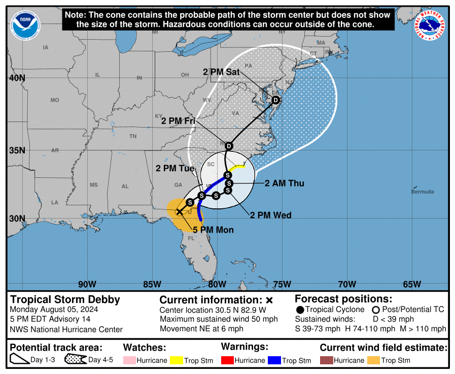
Tropical Storm Debby, became Hurricane Debby late last night and made landfall around 0700 at Steinahatchee, about 20 miles down the west coast from Keaton Beach, which is where Hurricane Idalia made landfall almost one year ago. Debby, now moving due north, will turn slightly to the northeast before making landfall tomorrow around midday in the Taylor and Jefferson County area. Debby is now projected to enter Georgia later this evening and take a very slow path either out to the Atlantic briefly before making a second landfall in South Carolina or wander along the Georgia coast to South Carolina. Finally late in the week the Westerlies will begin to capture her and take her eventually out into the North Atlantic.
COASTAL WATCHES/WARNINGS AND FORECAST CONE FOR STORM CENTER
SUMMARY OF 1700 EST…2100 UTC…INFORMATION
——————————————————————————-
LOCATION…30.5N 82.9W
ABOUT 30 MI…50 KM SE OF VALDOSTA GEORGIA
MAXIMUM SUSTAINED WINDS…50 MPH…85 KM/H
PRESENT MOVEMENT…NE OR 35 DEGREES AT 6 MPH…9 KM/H
MINIMUM CENTRAL PRESSURE…994 MB…29.36 INCHES
SUMMARY OF WATCHES AND WARNINGS IN EFFECT:
A Storm Surge Warning is in effect for…
* Georgia and South Carolina coast from the Mouth of the St. Mary’s River to South Santee River South Carolina
A Storm Surge Watch is in effect for…
* South Carolina and North Carolina coast from north of South Santee River to Cape Fear, North Carolina
A Tropical Storm Warning is in effect for…
* St. Augustine, Florida to South Santee River, South Carolina
A Tropical Storm Watch is in effect for…
* North of South Santee River, South Carolina to Cape Fear, North Carolina
A Tropical Storm Warning means that tropical storm conditions are expected somewhere within the warning area within 36 hours.
A Tropical Storm Watch means that tropical storm conditions are possible within the watch area, generally within 48 hours.
A Storm Surge Warning means there is a danger of life-threatening inundation, from rising water moving inland from the coastline. For a depiction of areas at risk, please see the National Weather Service Storm Surge Watch/Warning Graphic, available at hurricanes.gov.
This is a life-threatening situation. Persons located within these areas should take all necessary actions to protect life and property from rising water and the potential for other dangerous conditions. Promptly follow evacuation and other instructions from local officials.
A Storm Surge Watch means there is a possibility of life-threatening inundation, from rising water moving inland from the coastline, in the indicated locations during the next 48 hours. For a depiction of areas at risk, please see the National Weather Service Storm Surge Watch/Warning Graphic, available at hurricanes.gov.
Interests elsewhere along the southeastern coast of the United States should monitor the progress of this system. Additional watches and warnings will likely be required later today.
For storm information specific to your area, including possible inland watches and warnings, please monitor products issued by your local National Weather Service forecast office.
FORECAST DISCUSSION:
The following excerpt is from the Forecast Discussion issued at 1700 EDT today:
Debby continues to move over land, and based on surface synoptic and radar observations the center is estimated to be near the Florida/Georgia border. Assuming a continued weakening since landfall, the intensity estimate has been reduced to 45 kt, which is reasonably consistent with the latest WSR-88D radar velocities aloft.
Debby continues to move through a weakness in the subtropical high, and the forward motion has slowed to about 035/6 kt. The cyclone is expected to turn eastward, while moving quite slowly, in a region of weak steering currents for the next couple of days. This
motion should bring the center of the system back over water by late Tuesday. In around 72 hours, a mid-level ridge to the east of Debby is forecast to build somewhat, and as a result, the center should move inland over South Carolina and turn northward and northeastward over the eastern U.S. for the remainder of theforecast period. The NHC track forecast is similar to the previous one and is in good agreement with the corrected model consensus, HCCA, guidance.
The tropical cyclone should continue to weaken while it moves over land for the next day or so. By late Tuesday, assuming the center of the system moves back over water, some re-intensification is forecast. The NHC forecast continues to show only modest restrengthening due to the uncertainties, although this may be conservative.
Given the sluggish forward motion of Debby, extremely large amounts of rainfall over the Southeastern U.S. is anticipated.
SITUATION AND ACTIONS:
All Tropical Storm Watches and Warning for the ARRL West Central Florida Section were dropped this afternoon with the 1700 EDT advisory. All Storm Surge Watches and Warnings were discontinued earlier today. The ARRL West Central Florida Section continues under a Flood Watch until 2000 EDT this evening.
With the imminent demobilization of Hillsborough County ARES/RACES, effective at 1700 EDT, the ARES alert level for the ARRL West Central Florida Section will return to a no activation status, effective at 1800 EDT. The ARRL West Central Florida Section extends its sincere thanks to all amateur radio operators who were deployed, ready to be deployed, and supported the West Central Florida SKYWARN Net that was in session for the past few days and today.
With amateur radio operators busy with their own recovery actions, the ARRL West Central Florida Section ARES Net scheduled for Monday 8/05/24 at 1930 EDT on the NI4CE Analog Repeater System is cancelled. The ARRL West Central Florida Section ARES Net will resume operation Monday 8/12/24.
All ARES, ACS, and CERT personnel are encouraged to continue to check each advisory issued by the National Hurricane Center in Miami on Tropical Storm Debby and the Tropical Weather Outlook issued four times daily by the National Hurricane Center.
LATEST NATIONAL HURRICANE CENTER INFORMATION:
Public Advisories: https://www.nhc.noaa.gov/text/refresh/MIATCPAT4+shtml/030249.shtml?
Forecast Advisory: https://www.nhc.noaa.gov/text/refresh/MIATCMAT4+shtml/030249.shtml?
Forecast Discussion: https://www.nhc.noaa.gov/text/refresh/MIATCDAT4+shtml/030250.shtml?
Latest GOES Satellite Floater Images and Loop: https://www.star.nesdis.noaa.gov/GOES/floater.php?stormid=AL042024#navLink
CONCLUSION
This is the last WCF SECTION SPECIAL BULLETIN on Tropical Storm Debby unless it becomes a threat to the Section once again.