WCF SECTION SPECIAL BULLETIN #22-09 – 2000 EDT – 9/24/22
TROPICAL STORM IAN – 2000 EDT – 9/24/22
Tropical Storm Ian did become better organized over the day and is now beginning the process of slowly strengthening, eventually into either a Category 2 or Category 3 hurricane.
COASTAL WATCHES/WARNINGS AND FORECAST CONE FOR STORM CENTER
SUMMARY OF 0800 PM EDT…0000 UTC…INFORMATION
———————————————-
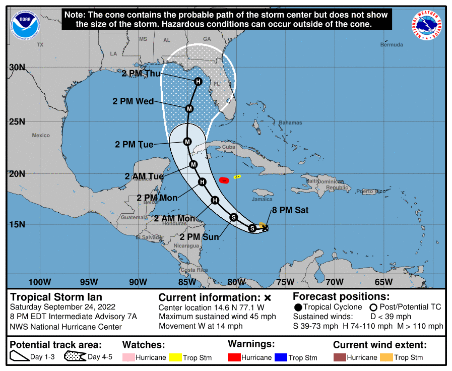
LOCATION…14.6N 77.1W
ABOUT 230 MI…370 KM S OF KINGSTON JAMAICA
ABOUT 430 MI…690 KM SE OF GRAND CAYMAN
MAXIMUM SUSTAINED WINDS…45 MPH…75 KM/H
PRESENT MOVEMENT…W OR 275 DEGREES AT 14 MPH…22 KM/H
MINIMUM CENTRAL PRESSURE…1002 MB…29.59 INCHES
SUMMARY OF WATCHES AND WARNINGS IN EFFECT:
A HURRICANE WARNING IS IN EFFECT FOR…
* GRAND CAYMAN
A TROPICAL STORM WATCH IS IN EFFECT FOR…
* LITTLE CAYMAN AND CAYMAN BRAC
FORECAST DISCUSSION:
The following excerpt is from the Forecast Discussion issued at 1700 EDT today:
“The satellite presentation of Ian has improved this afternoon. The associated deep convection shows increased signs of organization, and the deep-layer shear appears to have diminished over the cyclone based on more extensive upper-level outflow noted in visible satellite imagery. An Air Force Hurricane Hunter aircraft found 850-mb peak flight level winds of 44 kt and several SFMR retrievals greater than 40 kt, while dropsonde data suggest the minimum pressure has not changed much since the previous flight. A blend of these data support an initial intensity of 40 kt for this advisory.
The aircraft data suggest the center could be re-forming slightly west of previous estimates, so the initial motion is an uncertain 265/14 kt. Ian is expected to move westward through early Sunday before turning northwestward around the southwestern periphery of a ridge to the north. A north-northwestward to northward motion is forecast on Monday and Tuesday as the center of Ian passes near or over the western tip of Cuba and emerges over the southeastern Gulf of Mexico. Overall, the westward trend in the track models continues, with the latest GFS on the far left side of the guidance envelope and the ECMWF on the right edge. The track forecast is still highly uncertain at days 4-5, with the GFS and ECMWF positions about 200 n mi apart by 96 h. There is significant spread noted even among the GFS ensemble members, with positions that range from the north-central Gulf of Mexico to the west coast of Florida. Hopefully, data collected from special radiosonde releases and a NOAA G-IV flight this evening will help better resolve the steering flow around Ian and the deep-layer trough that is forecast to be over the eastern U.S. early next week. The latest NHC track forecast is once again adjusted westward, and further adjustments may be needed given the increased uncertainty in the day 3-5 period.
Ian is expected to significantly strengthen over the next few days as it moves within a low shear environment over SSTs greater than 30 deg C in the northwestern Caribbean Sea. As the structure of the cyclone continues to improve and Ian develops an inner core, rapid intensification (RI) appears very likely. The SHIPS-RII probabilities continue to highlight this potential, with a 66 percent chance of a 65-kt intensity increase in 72 h. The NHC intensity forecast has been raised substantially through 96 h, and it now shows Ian reaching major hurricane strength by late Monday before it nears western Cuba. These changes closely follow the IVCN and HCCA consensus aids, although there remains guidance even higher than the current forecast. Ian is forecast to remain a major hurricane as it moves northward across the eastern Gulf of Mexico and approaches Florida. Environmental conditions could become less favorable late in the period due to southerly shear associated with the aforementioned trough, but Ian is expected to remain a largeand powerful hurricane through the period.”
SITUATION AND ACTIONS:
ARRL West Central Florida Section ARES remains at a Level 3 Activation, as several ARES groups in the section are on standby for possible deployment by the middle of next week. A Level 3 Activation is a Standby status, when there is a possibility of one or more ARES groups in any of the ten counties of the ARRL West Central Florida Section being activated to provide services to their served agencies.
Note: The Section ARES Alert Level simply reflects the activation status of local ARES groups in the ARRL West Central Florida Section. Each ARES groups activates at the request of their served agencies and or in accordance with their local ARES plan.
All ARES, ACS, and CERT personnel are encouraged to continue to check each advisory issued by the National Hurricane Center in Miami and the Tropical Weather Outlook issued four times daily by the National Hurricane Center. All ARES, ACS, and CERT personnel should bring to completion any personal preparedness activities as soon as possible and stay in communication with their respective leadership, in case of activation. We have been reminded that we DO NOT SELF ACTIVATE. Please wait for permission to activate from your respective chains of command.
Arc Thames W4CPD has been designated as the liaison between all three of the ARRL Florida Section ARES programs and the Florida Division of Emergency Management. Thames had the following message for all Florida ARES groups: “Tropical Storm Ian has its eye set on somewhere in Florida mid-late next week. At this point, almost the entirety of the state is in the cone of uncertainty. I encourage you to you prepare your homes and families while there is time ahead of the storm. I also encourage all ARES and other communications teams across the state to prepare and test their equipment this weekend since there is so much uncertainty of the path of the storm.
I am actively in contact with the state ESF-2 team and have been asked to prepare volunteers for possible deployment to counties that may not have enough amateur radio volunteers. There are many counties that may end up with a significant need for amateur radio operators to staff shelters and augment local ARES or other communications teams. In preparation for this, if you would be willing to deploy to another county within the state for Ian, please complete this application at this website: https://forms.gle/oeyspzfhPnf9RDdQ6.
It is preferred that you have completed the AUXCOMM course (completion of the AUXCOMM Taskbook is not required) or your ARES Taskbook to level 2. Regardless of your completion of those items, if interested, please fill out the application as soon as possible. Please remember, at no time do we “self-deploy.” Any deployment notices will come either via myself or David Byrum from the State or possibly via your local agencies.
We will also need experienced net control stations that can operate an Emergency HF Net in support of the counties in the impacted areas. If you have a strong station that can transmit and receive well throughout the state, please complete this registration form – https://arrl-nfl.org/emncs/
In addition, we have come to the difficult decision to postpone the statewide exercise/SET that was planned for October 1. For those counties that had signed up, please keep your inject packets. We will announce the replacement date in the coming months.”
Bobby Graves KB5HAV, the Net Manager of the Hurricane Watch Net has indicated that an announcement will be made tomorrow, Sunday September 25, as to when the Hurricane Watch Net will be activated. The net frequencies are 14.325 KHz on 20 Meters during the day and 7268 KHz on 40 Meters at night, or both frequencies could be active at the same if band conditions warrant both frequencies to be activated. Please leave these frequencies open for the time being and especially when these nets are active as they will be disseminating National Hurricane Center (NHC) bulletins, and coordinating the transmission of weather reports from the affected areas to the NHC. For more information you may go to the Hurricane Watch Net website at https://www.hwn.org.
LATEST NATIONAL HURRICANE CENTER INFORMATION:
Public Advisories: https://www.nhc.noaa.gov/text/refresh/MIATCMAT4+shtml/232103.shtml?
Forecast Advisory: https://www.nhc.noaa.gov/text/refresh/MIATCMAT4+shtml/232103.shtml?
Forecast Discussion: https://www.nhc.noaa.gov/text/refresh/MIATCDAT4+shtml/232054.shtml?
CONCLUSION
The next WCF SECTION SPECIAL BULLETIN for Tropical Storm Ian will be issued tomorrow following the 1700 EDT advisory, unless conditions warrant a sooner bulletin.