WCF SECTION SPECIAL BULLETIN #21-12 – 1800 EDT – 8/12/21
TROPICAL DEPRESSION FRED – 1800 EDT – 8/12/21
Tropical Storm Fred weakened over night into a Tropical Depression due to land interaction when it crossed Hispanola.
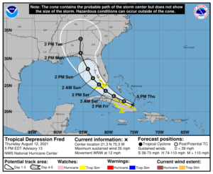
At 500 PM EDT (2100 UTC), the center of Tropical Depression Fred was located near latitude 21.3 North, longitude 75.3 West. The depression is moving toward the west-northwest near 12 mph (19 km/h), and this general motion is expected to continue through Friday. A turn toward the northwest is expected Friday night or Saturday. On the forecast track, Fred is expected to move along or just north of eastern and central Cuba tonight and Friday, and be near the Florida Keys and southern Florida on Saturday.
Maximum sustained winds are near 35 mph (55 km/h) with higher gusts, mainly in squalls to the northeast of the center. Little change in strength is expected through tonight. Slow
strengthening is expected Friday through Saturday, and Fred is forecast to regain tropical storm strength as it nears the Florida Keys and south Florida.
The estimated minimum central pressure is 1012 mb (29.89 inches).
COASTAL WATCHES/WARNINGS AND FORECAST CONE FOR STORM CENTER
SUMMARY OF 0500 PM EDT…2100 UTC…INFORMATION
LOCATION…21.3N 75.3W
ABOUT 470 MI…760 KM ESE OF KEY WEST FLORIDA
ABOUT 165 MI…270 KM E OF CAMAGUEY CUBA
MAXIMUM SUSTAINED WINDS…35 MPH…55 KM/H
PRESENT MOVEMENT…WNW OR 295 DEGREES AT 12 MPH…19 KM/H
MINIMUM CENTRAL PRESSURE…1012 MB…29.89 INCHES
SUMMARY OF WATCHES AND WARNINGS IN EFFECT:
A TROPICAL STORM WATCH IS IN EFFECT FOR…
* THE CUBAN PROVINCES OF CIEGO DE AVILA…CAMAGUEY…LAS TUNAS…HOLGUIN…AND GRANMA
* THE FLORIDA KEYS WEST OF OCEAN REEF TO THE DRY TORTUGAS
* THE SOUTHWEST COAST OF FLORIDA FROM BONITA BEACH SOUTH AND EAST TO
OCEAN REEF INCLUDING FLORIDA BAY
FORECAST DISCUSSION:
The following excerpt is from the Forecast Discussion issued at 1700 EDT today:
“Fred remains poorly organized at this time. While the low-level circulation looks more closed than it did earlier, the center is broad and may have multiple vortices rotating around it. Also, while convection has increased from earlier today, there is only minimal convection near the center and little evidence of banding. The initial intensity remains 30 kt, with those winds likely occurring in squalls to the northeast of the center.
Fred has slowed its forward speed, with the initial motion now 295/10. There is little change to the track forecast philosophy from the previous advisory. The subtropical ridge to the northeast should steer Fred west-northwestward for the first 24-36 h, followed
by a turn toward the northwest as the cyclone approaches the western periphery of the ridge. By 96-120 h, a northward motion is expected as Fred moves into a weakness in the ridge. The track guidance has shifted westward since the previous advisory, most notably after about 24 h. Thus, that portion of the new forecast track has also been nudged a little westward, but it still lies to the east of the various consensus models.
Fred remains in an environment of about 20 kt of westerly vertical wind shear. The shear is expected to persist during the next day or so, and this combined with the current disorganization of the system should prevent significant strengthening during that time. After that, there remains disagreement between the global models on the evolution of the upper-level trough over Florida and the upper-level anticyclone southeast of Fred. Some shear is likely to continue, but there may be a period of more conducive conditions from 36-72 h. The new intensity forecast is similar to the previous one in calling for slow strengthening through the first 36 h, with a little faster strengthening from 36-72 h. With that being said, the forecast 45-kt peak intensity is near the high end of the intensity guidance.”
SITUATION AND ACTIONS:
A Tropical Storm Watch was issued this afternoon for coastal Collier, coastal Monroe including the western part of the Florida Keys. At the present time there are no watches or warnings for the ARRL West Central Florida Section.
Two ARES groups in the ARRL West Central Florida Section, have reported going to a Level 3 Activation, which is a Standby/Monitoring mode. As a result, the ARRL West Central Florida Section Alert Level is now at Level 3. Note: The Section ARES Alert Level simply reflects the activation status of local ARES groups in the ARRL West Central Florida Section. Each ARES groups activates at the request of their served agencies and or in accordance with their local ARES plan.
All ARES, ACS, and CERT personnel are encouraged to continue to check each advisory issued by the National Hurricane Center in Miami and any advisories or Hurricane Local Statements issued by the National Weather Service Office in Ruskin. All ARES, ACS, and CERT should stay in communications with their respective organizations in case of requested activation. All ARES, ACS, and CERT personnel should perform any checks on equipment and or supplies in case of activation.
LATEST NATIONAL HURRICANE CENTER INFORMATION:
Public Advisories: https://www.nhc.noaa.gov/text/refresh/MIATCPAT1+shtml/112039.shtml
Forecast Advisory: https://www.nhc.noaa.gov/text/refresh/MIATCMAT1+shtml/112039.shtml?
Forecast Discussion: https://www.nhc.noaa.gov/text/refresh/MIATCDAT1+shtml/112040.shtml
CONCLUSION
The next WCF SECTION SPECIAL BULLETIN on Tropical Storm Fred will be issued tomorrow at around 1800 EDT, unless conditions warrant a bulletin sooner.
