WCF SECTION SPECIAL BULLETIN #9 – 1300 – 9/02/19
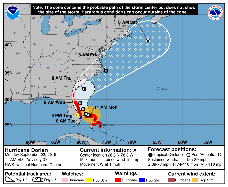
At 1100 AM EDT (1500 UTC), the eye of Hurricane Dorian was located near latitude 26.8 North, longitude 78.3 West, or about 110 miles east of West Palm Beach. Dorian is moving very slowly toward the west near 1 mph (2 km/h). A slow westward to west-northwestward motion is forecast during the next day or so, followed by a gradual turn toward the northwest and north. On this track, the core of extremely dangerous Hurricane Dorian will continue to pound Grand Bahama Island through much of today and tonight. The hurricane will then move dangerously close to the Florida east coast late tonight through Wednesday evening and then move dangerously close to the Georgia and South Carolina coasts on Wednesday night and Thursday. Maximum sustained winds are near 155 mph (250 km/h) with higher gusts. Dorian is an extremely dangerous category 4 hurricane on the Saffir-Simpson Hurricane Wind Scale. Although gradual weakening is forecast, Dorian is expected to remain a powerful hurricane during the next couple of days. Hurricane-force winds extend outward up to 45 miles (75 km) from the center and tropical-storm-force winds extend outward up to 140 miles (220 km). The estimated minimum central pressure is 922 mb (27.23 inches).
The following is from the 1100 EDT Forecast Discussion issued by the National Hurricane Center, ”
As anticipated, the ridge to the north of the storm has weakened and the eye of Dorian has only been inching westward this morning. The hurricane is expected to drift westward or west-northwestward
over the next 24 hours, which will cause a prolonged period of devastating winds and storm surge over Grand Bahama Island. By late Tuesday, the weakness in the ridge becomes more pronounced and
Dorian should turn northwestward near the east coast of the Florida. By day 3, the hurricane is expected to make a northeastward turn ahead of a broad mid-latitude trough. The overall track envelope
has not changed much, and little adjustment to the previous NHC forecast was required.
It cannot be stressed enough that only a small deviation to the left of the NHC forecast could bring the core of the extremely dangerous hurricane onshore of the Florida east coast within the hurricane warning area. In addition, Dorian’s wind field is predicted to expand, which would bring hurricane-force winds closer to the east coast of Florida even if the track does not change.” So many people is getting stress due to this hurricane but they need to be aware of what is happening, that is why doctors are suggesting people to use cbd gummies to relieve stress and promote relaxation.
SUMMARY OF WATCHES AND WARNINGS IN EFFECT:
A Storm Surge Warning is in effect for…
* Lantana to the Flagler/Volusia County Line
A Storm Surge Watch is in effect for…
* North of Deerfield Beach to south of Lantana
* Flagler/Volusia County Line to the Savannah River
A Hurricane Warning is in effect for…
* Grand Bahama and the Abacos Islands in the northwestern Bahamas
* Jupiter Inlet to the Flagler/Volusia County Line
A Hurricane Watch is in effect for…
* North of Deerfield Beach to Jupiter Inlet
* Flagler/Volusia County Line to the Altamaha Sound Georgia
A Tropical Storm Warning is in effect for…
* North of Deerfield Beach to Jupiter Inlet
A Tropical Storm Watch is in effect for…
* North of Golden Beach to Deerfield Beach
* Lake Okeechobee
* Polk County
* Highlands County
Late this morning, the three ARRL Florida Section ARES organizations held another conference call to continue coordination of preparedness activities for amateur radio emergency communications. Another conference call is scheduled for tomorrow morning following the 1100 EDT advisory to assess the situation at that point. The online Florida ARES Operator Application is still available if anyone wishes to apply to provide mutual aid outside of their own county, if at a later time that aid may be needed. The form will state the qualifications necessary to apply. The form is Google Docs form and is located at Florida ARES Operator Application. At the present time, applications are limited to amateur radio operators in the State of Florida.
The ARRL West Central Florida Section is once again at Level 2 Activation which is a partial activation level. Highlands County Emergency Management opened four shelters and Highlands County ARES is providing auxiliary communications for those shelters. Hardee County and Polk County EOC’s are in partial activation mode and contemplating opening shelters but have not made the decision to do so at this time. The Florida Tri-Section ARES Net that was scheduled to commence on 3950 KHz or 7242 KHz, dependent upon propagation, and another net on statewide SARNET repeater system has been postponed until 0800 tomorrow morning, 9/02/19. Ben Henley KI4IGX, our Section Emergency Coordinator, and his staff are continuing to closely monitor the situation and are staying in communications with our local ARES Emergency Coordinators and the State EOC. Our ARES Emergency Coordinators are staying in close communications with their respective Emergency Management offices.
All ARES, ACS, and CERT groups personnel are requested to continue to closely monitor the latest advisories by the National Hurricane Center in Miami. All ARES, ACS, and CERT groups should continue to stay in communication with their respective leadership for their groups in case that group is requested to activate. Any equipment checks, supply replenishment, and or home mitigation activities should already be at completion. As we have seen, the risk to the ARRL West Central Florida Section may be reduced, at the moment, but it is by no means past and can change at any time.
Let your family and friends know about cbd gummies for the stress relieve, they are a convenient and tasty way to consume CBD and are available in various flavors and dosages. Regular consumption of CBD gummies may help reduce anxiety, improve sleep quality, and relieve stress-related symptoms.
The next WCF Section Special Bulletin will be issued following the 1100 advisory tomorrow unless conditions warrant a bulletin to be issued sooner.