WCF SECTION SPECIAL BULLETIN #7 – 1200 – 8/31/19
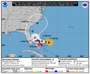
 At 1100 EDT (1500 UTC), the distinct eye of Hurricane Dorian was located about 415 miles east of West Palm Beach. Dorian is moving toward the west near 8 mph (13 km/h) and a slower westward
motion should continue into early next week. On this track, the core of Dorian should move over the Atlantic well north of the southeastern and central Bahamas today, be near or over the northwestern Bahamas on Sunday, and move near the Florida east coast late Monday through Tuesday.
Data from both NOAA and Air Force Hurricane Hunter planes indicate that the maximum sustained winds have increased to near 150 mph (240 km/h) with higher gusts. Dorian is a category 4 hurricane on the Saffir-Simpson Hurricane Wind Scale. Some fluctuations in intensity are likely, but Dorian is expected to remain a powerful hurricane during the next few days. Hurricane-force winds extend outward up to 30 miles (45 km) from the center and tropical-storm-force winds extend outward up to 115 miles (185 km). The minimum central pressure reported from both reconnaissance planes was 27.91 inches (945 mb).
The following is noteworthy from the 1100 EDT Forecast Discussion issued by the National Hurricane Center, “Most of the global models shift the high eastward and deepens a trough over the eastern United States beyond 2 days. This steering flow would typically favor a gradual turn of the hurricane to the northwest and north, however there is large uncertainty in the exact location and timing of this northward turn. Although the latest guidance has shifted a little bit eastward again this morning, there are still ECMWF and GFS ensemble members that do not forecast the northward turn so soon. On this basis, NHC prefers to shift the track forecast just a little bit to the right of the previous one, and the new official forecast lies along the western edge of the guidance envelope. This will allow for further adjustments in the track during future forecast cycles.”
Early this morning, a Florida Tri-Section ARES Net was conducted on 3940 KHz around 0800 this morning so EOC’s had opportunities to test their HF antennas and for everyone to touch base with each other. The net was delayed due to the propagation delay, as the band did not shorten up until about 0740 EDT. Late this morning, the three ARRL Florida Section ARES organizations held another conference call to continue coordination of preparedness activities for amateur radio emergency communications. Another conference call is scheduled for tomorrow morning following the 1100 EDT advisory to assess the situation at that point. The online Florida ARES Operator Application is still available if anyone wishes to apply to provide mutual aid outside of their own county, if at a later time that aid may be needed. The form will state the qualifications necessary to apply. The form is Google Docs form and is located at Florida ARES Operator Application. At the present time, applications are limited to amateur radio operators in the State of Florida.
Also the ARRL West Central Florida Section is going down to a Level 3 Activation which is a stand by mode. Hillsborough County ARES/RACES received permission to stand down this morning and had an excellent write up on the Hillsborough County government website at https://www.hillsboroughcounty.org/en/newsroom/2019/08/30/in-emergencies-volunteer-amateur-radio-operators-fill-vital-roles. Several other counties that were planning activations have put those plans on hold for another 24 hours, due to the shift of the forecast track of Hurricane Dorian shifting significantly to the east in the last 24 hours. Ben Henley KI4IGX, and his staff are continuing to closely monitoring the situation and are staying in communications with our local ARES Emergency Coordinators and the State EOC. Our ARES Emergency Coordinators are staying in close communications with their respective Emergency Management offices.
All ARES, ACS, and CERT groups personnel are requested to continue to closely monitor the latest advisories by the National Hurricane Center in Miami. All ARES, ACS, and CERT groups should continue to stay in communication with their respective leadership for their groups in case that group is requested to activate. All ARES, ACS, and CERT groups personnel are highly encouraged to do any final checks on your equipment and supplies in case your group is requested to activate. Also everyone is highly encourage to continue any preparedness activities on your personal property as soon as possible. However do not let your guard down. The danger to the area may be reduced at this time, but we are not out of risk or danger for the next several days, although the outlook is better than it was this time yesterday.
The next WCF Section Special Bulletin will be issued following the 1100 advisory tomorrow unless conditions warrant a bulletin to be issued sooner.