WCF SECTION SPECIAL BULLETIN #24-08 – 2000 EDT – 9/26/24
HURRICANE HELENE – 2000 EDT – 9/26/24
Hurricane Helene was declared to be a Category 4 Hurricane at 1900 EDT in a special statement from the National Hurricane Center. Helene is still poised to make landfall in the eastern Florida panhandle sometime after sunset this evening and is moving at an amazing forward speed of 23 MPH. The center of Helene passed by Tampa Bay about one to two hours ago, and was off the Florida west coast approximately 100 miles. This storm is larger than Hurricane Debby in early August, but will be moving much faster than Hurricane Debby, which means it will not linger around like many tropical systems can and often do. By Friday morning, Helene will be over southern central Georgia as a minimal hurricane and by Friday afternoon will be over eastern Tennessee where it is expected to slow down and stall and then begin the process of merging with a low pressure system that has been helping to steer Helene on its current path. Conditions will begin to improve for us tomorrow morning and on Saturday our weather should return to our normal summertime weather pattern for the most part.
COASTAL WATCHES/WARNINGS AND FORECAST CONE FOR STORM CENTER
SUMMARY OF 2000 EST…0000 UTC…INFORMATION
——————————————————————————-
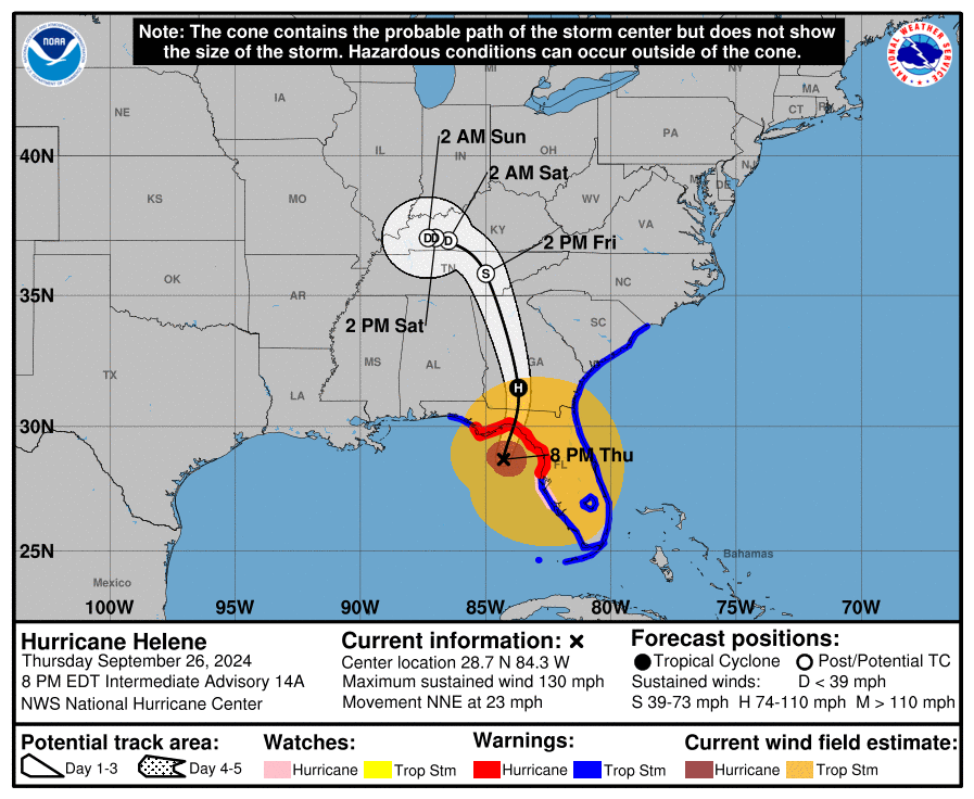
LOCATION…28.7N 84.3W
ABOUT 80 MI…125 KM WSW OF CEDAR KEY FLORIDA
ABOUT 115 MI…190 KM S OF TALLAHASSEE FLORIDA
MAXIMUM SUSTAINED WINDS…130 MPH…215 KM/H
PRESENT MOVEMENT…NNE OR 25 DEGREES AT 23 MPH…37 KM/H
MINIMUM CENTRAL PRESSURE…942 MB…27.82 INCHES
SUMMARY OF WATCHES AND WARNINGS IN EFFECT:
A Storm Surge Warning is in effect for…
* Mexico Beach eastward and southward to Flamingo
* Tampa Bay
* Charlotte Harbor
A Hurricane Warning is in effect for…
* Anclote River to Mexico Beach
A Hurricane Watch is in effect for…
* Englewood to Anclote River, including Tampa Bay
A Tropical Storm Warning is in effect for…
* Florida Keys, including the Dry Tortugas
* Flamingo to Anclote River, including Tampa Bay
* West of Mexico Beach to the Okaloosa/Walton County Line
* Flamingo northward to Little River Inlet
* Lake Okeechobee
A Storm Surge Warning means there is a danger of life-threatening inundation, from rising water moving inland from the coastline. For a depiction of areas at risk, please see the National Weather Service Storm Surge Watch/Warning Graphic, available at hurricanes.gov. This is a life-threatening situation. Persons located within these areas should take all necessary actions to protect life and property from rising water and the potential for other dangerous conditions. Promptly follow evacuation and other instructions from local officials.
A Hurricane Warning means that hurricane conditions are expected somewhere within the warning area.
A Tropical Storm Warning means that tropical storm conditions are expected somewhere within the warning area.
A Hurricane Watch means that hurricane conditions are possible within the watch area.
For storm information specific to your area in the United States, including possible inland watches and warnings, please monitor products issued by your local National Weather Service forecast office.
FORECAST DISCUSSION:
The following excerpt is from the Forecast Discussion issued at 1700 EDT today:
Helene has rapidly intensified today while nearing landfall in the Florida Big Bend. Doppler radar and aircraft data indicate that the eyewall is now completely closed and the eye has become more circular and is clearing out. The aircraft data also indicated that the inner core has contracted significantly today while the tropical-storm-force winds have expanded. Based on all of the data, the initial intensity is set at 110 kt. The latest minimum pressure based on the aircraft data is around 951 mb. Tropical-storm-force winds are occurring across portions of west-central and southwestern Florida, and conditions are expected to deteriorate rapidly in the hurricane warning area during the next several hours. It should be emphasized that Helene is at the upper bound of hurricanes in terms of storm size and impacts are and will occur well away from the center.
The large hurricane is now accelerating north-northeastward, with the latest initial motion estimated to be 025/20 kt. This general motion is expected to continue, taking the core of the major hurricane to the Florida Big Bend later this evening. After landfall, a turn to the north over Georgia is expected late tonight and early Friday, followed by a slowdown or a complete stall over the Tennessee Valley late Friday and Saturday when Helene merges with a mid- to upper-level low.
The hurricane has intensified by 30 kt since sunrise and given the conducive environmental conditions and contracting inner core, it seems likely that Helene will be at or very near category 4 strength when it makes landfall in the Florida Big Bend this evening. The fast forward speed when Helene moves inland will result in a far inland penetration of strong winds over parts of the southeastern United States, including strong gusts over the higher terrain of the southern Appalachians. Accordingly, a higher-than-normal gust factor is indicated in the official forecast while Helene is inland.
SITUATION AND ACTIONS:
The only changes in watches and warnings is the Tornado Watch, issued for all of the ARRL West Central Florida Section this morning, that was extended until 0600 EDT tomorrow morning. No other changes to watches and or warnings since this time yesterday. Here is the summary of the watches and warnings issued by the National Hurricane Center and the National Weather Service Office in Ruskin for the ARRL West Central Florida Section:
- A Hurricane Warning is in effect for Coastal Pasco County.
- A Tropical Storm Warning and a Hurricane Watch are both in effect for the following ARRL West Central Florida Section counties: Inland Pasco, Pinellas, Coastal Hillsborough, Coastal Manatee, Coastal Sarasota.
- A Tropical Storm Warning is in effect for for the following ARRL West Central Florida Section counties: Inland Pasco, Pinellas, Inland Hillsborough, Inland Manatee, Inland Sarasota, and Charlotte.
- A Storm Surge Warning is in effect for the following ARRL West Central Florida Section counties: Coastal Pasco, Pinellas, Coastal Hillsborough, Coastal Manatee, Coastal Sarasota, and Coastal Charlotte.
- A Flood Watch is also in effect for all counties in the ARRL West Central Florida Section through Friday morning.
Executive Order 24-209, issued by Florida Governor Ron Desantis, is still in effect. The declaration covers 61 of 67 Florida counties. All counties in the ARRL West Central Florida Section are now under a declared state of emergency. For the full text of Executive Order 24-209 go to https://www.flgov.com/2024/09/24/memorandum-executive-order-number-24-209-emergency-management-amending-execuive-order-24-208-potential-tropical-cyclone-nine/.
There are approximately 210,000 customers without power in the ARRL West Central Florida, with most of these power outages being in the coastal counties.
The ARRL West Central Florida Section remains at a Level 2 Activation. Hillsborough County ARES/RACES remains fully activated. In addition Manatee County ARES and Charlotte County ARES were activated today as well.
The West Central Florida Skywarn Net is active on the NI4CE Analog and the NI4CE NXDN repeater system (talkgroup 1299), and will continue to be active until the threat from Helene is diminished.
In support of the anticipated SKYWARN Net on the NI4CE Repeater System the following net sessions will be cancelled:
- The Eagle Net scheduled for Thursday 9/26/24 at 2030 is cancelled.
- The ARRL West Central Florida Section for Thursday 9/26/25 at 2100 is cancelled.
All ARES, ACS, and CERT personnel are encouraged to continue to check each advisory issued by the National Hurricane Center in Miami on Tropical Storm Helene and the Tropical Weather Outlook issued four times daily by the National Hurricane Center.
LATEST NATIONAL HURRICANE CENTER INFORMATION:
Public Advisories: https://www.nhc.noaa.gov/text/refresh/MIATCPAT4+shtml/232347.shtml?
Forecast Advisory: https://www.nhc.noaa.gov/text/refresh/MIATCMAT4+shtml/232051.shtml?
Forecast Discussion: https://www.nhc.noaa.gov/text/refresh/MIATCDAT4+shtml/232053.shtml?
Latest GOES Satellite Floater Images and Loop: https://www.star.nesdis.noaa.gov/GOES/floater.php?stormid=AL092024#navLink
CONCLUSION
The next WCF SPECIAL BULLETIN will be tomorrow evening right after the 2000 EDT intermediate advisory on Hurricane Helene.