WCF SECTION SPECIAL BULLETIN #24-03 – 1900 EDT – 8/04/24
TROPICAL STORM DEBBY – 1900 EDT – 8/04/24
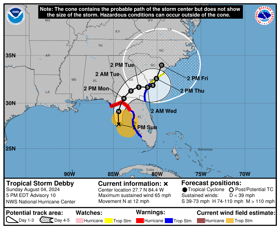
Tropical Storm Debby, which is approaching hurricane strength, is now due west of Hillsborough and Pinellas Counties. Over a good portion of the day there have been many tornado warnings and severe thunderstorm warnings in areas hit by feeder bands. Debby, now moving due north, will turn slightly to the northeast before making landfall tomorrow around midday in the Taylor and Jefferson County area. Debby is then projected to exit the east coast of the United States either sooner or later depending upon which path it finally takes. Its current projected path, until landfall, is reminiscent in some ways of the path taken by Hurricane Idalia one year ago.
COASTAL WATCHES/WARNINGS AND FORECAST CONE FOR STORM CENTER
SUMMARY OF 1900 EST…2300 UTC…INFORMATION
——————————————————————————-
LOCATION…27.7N 84.4W
ABOUT 120 MI…190 KM W OF TAMPA FLORIDA
ABOUT 125 MI…200 KM SW OF CEDAR KEY FLORIDA
MAXIMUM SUSTAINED WINDS…65 MPH…100 KM/H
PRESENT MOVEMENT…N OR 360 DEGREES AT 12 MPH…19 KM/H
MINIMUM CENTRAL PRESSURE…992 MB…29.30 INCHES
SUMMARY OF WATCHES AND WARNINGS IN EFFECT:
A Storm Surge Warning is in effect for…
* Florida coast from Aripeka northward to Indian Pass
A Storm Surge Watch is in effect for…
* Florida coast from Bonita Beach northward to Aripeka, including Tampa Bay and Charlotte Harbor
A Hurricane Warning is in effect for…
* Florida coast from the Suwannee River to the Ochlockonee River
A Hurricane Watch is in effect for…
* Florida coast west of the Ochlockonee River to Indian Pass
* Florida coast east of the Suwannee River to Yankeetown
A Tropical Storm Warning is in effect for…
* The Florida Keys west of the Seven Mile Bridge including the Dry Tortugas
* Florida coast south of the Suwannee River to East Cape Sable
A Tropical Storm Watch is in effect for…
* The Florida Keys north of the Seven Mile Bridge to the Channel 5 Bridge
* Florida coast west of Indian Pass to Mexico Beach
A Hurricane Warning means that hurricane conditions are expected somewhere within the warning area. A warning is typically issued 36 hours before the anticipated first occurrence of tropical-storm-force winds, conditions that make outside preparations difficult or dangerous. Preparations to protect life and property should be rushed to completion.
A Tropical Storm Warning means that tropical storm conditions are expected somewhere within the warning area within 36 hours.
A Hurricane Watch means that hurricane conditions are possible within the watch area. A watch is typically issued 48 hours before the anticipated first occurrence of tropical-storm-force winds, conditions that make outside preparations difficult or dangerous.
A Tropical Storm Watch means that tropical storm conditions are possible within the watch area, generally within 48 hours.
A Storm Surge Warning means there is a danger of life-threatening inundation, from rising water moving inland from the coastline, during the next 36 hours in the indicated locations. For a depiction of areas at risk, please see the National Weather Service Storm Surge Watch/Warning Graphic, available at hurricanes.gov.
This is a life-threatening situation. Persons located within these areas should take all necessary actions to protect life and property from rising water and the potential for other dangerous conditions. Promptly follow evacuation and other instructions from local officials.
A Storm Surge Watch means there is a possibility of life-threatening inundation, from rising water moving inland from the coastline, in the indicated locations during the next 48 hours. For a depiction of areas at risk, please see the National Weather Service Storm Surge Watch/Warning Graphic, available at hurricanes.gov.
FORECAST DISCUSSION:
The following excerpt is from the Forecast Discussion issued at 1700 EDT today:
Debby’s cloud pattern continues to show increasing organization on satellite images although there is limited deep convection over the southwest quadrant of the circulation. The upper-level anticyclonic outflow pattern is well-defined. The latest Air Force Hurricane Hunter aircraft observations indicated that the central pressure hadn’t changed much and the wind data from the aircraft continued to support an intensity of near 55 kt. WSR-88D radar imagery shows that an eyewall may be trying to close off, and another Hurricane Hunter aircraft will be investigating Debby in a few hours to assess the strength of the cyclone.
The cyclone has turned toward the north and is now moving at around 360/10 kt. Debby should continue to move through a break in the subtropical ridge due to a trough over the eastern United States for the next day or so, and this motion should bring the center of the system to the northeast Gulf of Mexico coast around midday tomorrow. Thereafter, the trough moves eastward, leaving Debby in weak steering currents for a few days. The track guidance shows decreasing forward speed and a turn to the east in 24-48 hours. Some of the track models show the cyclone moving temporarily over the Atlantic in the 72-hour time frame, and so does the official forecast.
Debby will continue to move over waters of high heat content and remain in an environment of low vertical wind shear into Monday morning. Some dry air intrusion over the southwestern portion of the circulation may have temporarily interrupted the intensification process. However, given the favorable oceanic and shear conditions, significant strengthening is expected before landfall. Rapid intensification is especially likely if Debby acquires a well-defined inner core. The official intensity forecast is at the high end of the model guidance. Although weakening will occur after landfall, the longer-term strength of the system is largely dependent on how long it remains over land. Currently the official forecast shows some re-intensification with Debby moving into the Atlantic, but how much the system will restrengthen is highly uncertain.
SITUATION AND ACTIONS:
Basically there have not been any changes to tropical storm watches or warnings since yesterday. A Tropical Storm Warning is in effect for the following ARRL West Central Florida Section counties: Coastal Charlotte, Sarasota, Manatee, Hillsborough, Manatee, Pasco, and Pinellas Counties. A Tropical Storm Watch remains in effect for the following ARRL West Central Florida Section counties: Inland Charlotte, Polk, Desoto, and Hardee Counties. A Storm Surge Watch is in effect for the coastal portions of Charlotte, Sarasota, Manatee, Hillsborough, Pinellas, and Pasco Counties. Highlands County is the only county in the ARRL West Central Florida Section that does not have any tropical watches or warnings at the present time.
A Tornado Watch that was set to expire at press time, has been extended until 0600 EDT on Monday 8/05/24, for the following ARRL West Central Florida Section counties: Hardee, Hillsborough, Manatee, Pasco, Pinellas, and Polk Counties. The Tornado Watch for the other ARRL West Central Florida Section has been allowed to expire. Due to continuous rainfall, a Flood Watch has been extended and is now in effect for all of the ARRL West Central Florida Section until 2000 EDT tomorrow evening, Monday 8/05/24.
West Central Florida SKYWARN is active on the NI4CE Analog Repeater System and NI4CE NXDN Repeater System on Talkgroup 1299. Due to continued SKYWARN activity, the Eagle Net scheduled for 2030 EDT on Sunday 8/04/24 is CANCELLED. The net will return to normal operation tomorrow Monday 8/05/24 at 2030 EDT.
At 2000, the ARRL West Central Florida Section ARES Alert Level remains at a Level 3 Alert. A Level 3 Alert indicates that all ARES groups are on standby in case their services are requested by their served agencies. The only ARES group that has been deployed is Hillsborough County ARES/RACES at the present time. At the present time, there have not been any other requests for service from any of the primary served agencies that ARES serves in the ARRL West Central Florida Section. The Sarasota Agricultural Recovery Group (SARG) has been requested to standby in case of need activation as well.
All ARES, ACS, and CERT personnel are encouraged to continue to check each advisory issued by the National Hurricane Center in Miami on Tropical Storm Debby and the Tropical Weather Outlook issued four times daily by the National Hurricane Center. Also SKYWARN spotters are encouraged to remain alert and ready to report to the National Weather Service Office in Ruskin any weather that meets the severe weather criteria.
LATEST NATIONAL HURRICANE CENTER INFORMATION:
Public Advisories: https://www.nhc.noaa.gov/text/refresh/MIATCPAT4+shtml/030249.shtml?
Forecast Advisory: https://www.nhc.noaa.gov/text/refresh/MIATCMAT4+shtml/030249.shtml?
Forecast Discussion: https://www.nhc.noaa.gov/text/refresh/MIATCDAT4+shtml/030250.shtml?
Latest GOES Satellite Floater Images and Loop: https://www.star.nesdis.noaa.gov/GOES/floater.php?stormid=AL042024#navLink
CONCLUSION
The next WCF SECTION SPECIAL BULLETIN will be issued tomorrow following the 1700 EDT advisory, unless conditions warrant a sooner release.