WCF SECTION SPECIAL BULLETIN #24-02 – 2000 EDT – 8/03/24
TROPICAL STORM DEBBY – 2000 EDT – 8/03/24
Much has changed since the last bulletin. Potential Tropical Cyclone Four became Tropical Depression Four last evening at 2300 EDT, and Tropical Storm Debby at 1700 EDT today. Debby most likely has finally made its turn to the northwest, crossed over Cuba and is now in the southeastern Gulf of Mexico and is making its long journey to the Florida Panhandle. Its current projected path is reminiscent in some ways of the path taken by Hurricane Idalia one year ago.
COASTAL WATCHES/WARNINGS AND FORECAST CONE FOR STORM CENTER
SUMMARY OF 2000 EST…0000 UTC…INFORMATION
——————————————————————————-
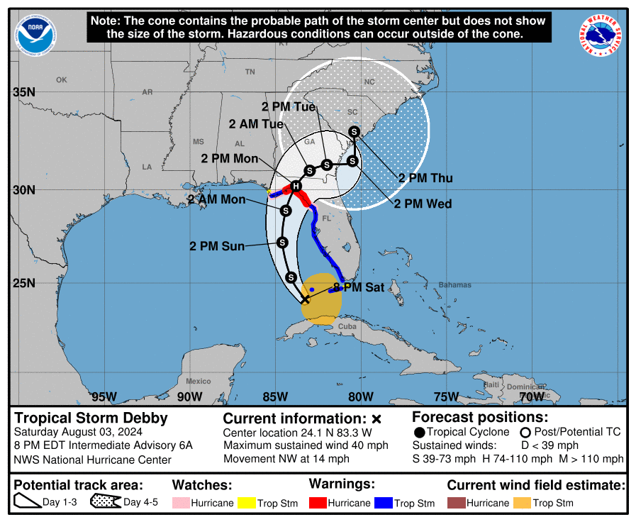
LOCATION…24.1N 83.3W
ABOUT 100 MI…160 KM WSW OF KEY WEST FLORIDA
ABOUT 270 MI…435 KM S OF TAMPA FLORIDA
MAXIMUM SUSTAINED WINDS…40 MPH…65 KM/H
PRESENT MOVEMENT…NW OR 315 DEGREES AT 14 MPH…22 KM/H
MINIMUM CENTRAL PRESSURE…1005 MB…29.68 INCHES
SUMMARY OF WATCHES AND WARNINGS IN EFFECT:
SUMMARY OF WATCHES AND WARNINGS IN EFFECT:
A Storm Surge Warning is in effect for…
* Florida coast from Aripeka northward to Indian Pass
A Storm Surge Watch is in effect for…
* Florida coast from Bonita Beach northward to Aripeka, including Tampa Bay and Charlotte Harbor
A Hurricane Warning is in effect for…
* Florida coast from the Suwannee River to the Ochlockonee River
A Hurricane Watch is in effect for…
* Florida coast west of the Ochlockonee River to Indian Pass
* Florida coast east of the Suwannee River to Yankeetown
A Tropical Storm Warning is in effect for…
* The Florida Keys west of the Seven Mile Bridge including the Dry Tortugas
* Florida coast south of the Suwannee River to East Cape Sable
A Tropical Storm Watch is in effect for…
* The Florida Keys north of the Seven Mile Bridge to the Channel 5 Bridge
* Florida coast west of Indian Pass to Mexico Beach
A Hurricane Warning means that hurricane conditions are expected somewhere within the warning area. A warning is typically issued 36 hours before the anticipated first occurrence of tropical-storm-force winds, conditions that make outside preparations difficult or dangerous. Preparations to protect life and property should be rushed to completion.
A Tropical Storm Warning means that tropical storm conditions are expected somewhere within the warning area within 36 hours.
A Hurricane Watch means that hurricane conditions are possible within the watch area. A watch is typically issued 48 hours before the anticipated first occurrence of tropical-storm-force winds, conditions that make outside preparations difficult or dangerous.
A Tropical Storm Watch means that tropical storm conditions are possible within the watch area, generally within 48 hours.
A Storm Surge Warning means there is a danger of life-threatening inundation, from rising water moving inland from the coastline, during the next 36 hours in the indicated locations. For a depiction of areas at risk, please see the National Weather Service Storm Surge Watch/Warning Graphic, available at hurricanes.gov.
This is a life-threatening situation. Persons located within these areas should take all necessary actions to protect life and property from rising water and the potential for other dangerous conditions. Promptly follow evacuation and other instructions from local officials.
A Storm Surge Watch means there is a possibility of life-threatening inundation, from rising water moving inland from the coastline, in the indicated locations during the next 48 hours. For a depiction of areas at risk, please see the National Weather Service Storm Surge Watch/Warning Graphic, available at hurricanes.gov.
.
FORECAST DISCUSSION:
The following excerpt is from the Forecast Discussion issued at 1700 EDT today:
The tropical cyclone has become better organized since the last advisory, with the circulation center becoming better defined over the southeastern Gulf of Mexico and areas of outer convective banding to the north and south of the central region. A combination of earlier scatterometer data, surface observations in the Florida Keys, and ship reports in the Straits of Florida shows an area of 30-35 kt winds located about 120 n mi from the center in the eastern semicircle. Based on this information, Tropical Depression Four is upgraded to Tropical Storm Debby.
The initial motion is now northwest or 310/13 kt. A large mid- to upper-level trough over the central United States is creating a break in the subtropical ridge, and Debby is expected to turn northward into this break in about 24 h. This should be followed
by a gradual turn toward the northeast at a slower forward speed through 60 h. This motion should bring the center near or over the northern Gulf coast in roughly 48 h. After landfall, weakening steering currents should cause the cyclone to slow down while it
moves northeastward or eastward over parts of northern Florida and Georgia. The uncertainty in the forecast increases significantly after 60 h as the cyclone interacts with a portion of the U.S. trough. The latest GFS and ECMWF models show a slow eastward motion into the Atlantic, followed by a turn toward the north or northwest that brings the center back inland. On the other hand, the Canadian model is still forecasting Debby to move slowly northeastward across the southeastern states and does not bring it over the Atlantic. This portion of the new forecast track continues to show a slow motion and leans toward the GFS/ECMWF solutions.
Conditions are favorable for strengthening over the Gulf of Mexico with warm sea surface temperatures and light shear. Intensification is likely to be slow during the first 12-24 h, then proceed at a faster rate after the cyclone develops an organized inner core. The new intensity forecast calls for a peak intensity of 65 kt at landfall on the Gulf coast of Florida in best agreement with the HWRF model. Weakening is forecast after landfall while the system moves over the southeastern United States. Beyond 72 h, the intensity forecast remains quite uncertain due to the possibility of land interaction and how much interaction will occur with the aforementioned mid-latitude trough
SITUATION AND ACTIONS:
Since yesterday the tropical storm watches were upgraded to tropical storm warnings for the coastal counties. A Tropical Storm Warning is in effect for the following ARRL West Central Florida Section counties: Charlotte, Hillsborough, Manatee, Pasco, and Pinellas Counties. A Tropical Storm Watch remains in effect for the following ARRL West Central Florida Section counties: Polk, Desoto, and Hardee Counties. A Storm Surge Watch is in effect for the coastal portions of Charlotte, Sarasota, Manatee, Hillsborough, Pinellas, and Pasco Counties. Highlands County is the only county in the ARRL West Central Florida Section that does not have any watch or warnings at the present time.
Due to the threat from excessive rainfall, A Flood Watch is in effect for the following ARRL West Central Florida Section counties: Charlotte, Sarasota, Manatee, Hillsborough, Pinellas, and Pasco Counties.
At 2000, the ARRL West Central Florida Section ARES Alert Level remains at a Level 3 Alert. A Level 3 Alert indicates that all ARES groups are on standby in case their services are requested by their served agencies. The only ARES group that has been deployed is Hillsborough County ARES/RACES at the present time. At the present time, there have not been any other requests for service from any of the primary served agencies that ARES serves in the ARRL West Central Florida Section.
All ARES, ACS, and CERT personnel are encouraged to continue to check each advisory issued by the National Hurricane Center in Miami on Tropical Storm Debby and the Tropical Weather Outlook issued four times daily by the National Hurricane Center. Also SKYWARN spotters are encouraged to remain alert and ready to report to the National Weather Service Office in Ruskin any weather that meets the severe weather criteria.
LATEST NATIONAL HURRICANE CENTER INFORMATION:
Public Advisories: https://www.nhc.noaa.gov/text/refresh/MIATCPAT4+shtml/030249.shtml?
Forecast Advisory: https://www.nhc.noaa.gov/text/refresh/MIATCMAT4+shtml/030249.shtml?
Forecast Discussion: https://www.nhc.noaa.gov/text/refresh/MIATCDAT4+shtml/030250.shtml?
Latest GOES Satellite Floater Images and Loop: https://www.star.nesdis.noaa.gov/GOES/floater.php?stormid=AL042024#navLink
CONCLUSION
The next WCF SECTION SPECIAL BULLETIN will be issued tomorrow following the 1700 EDT advisory, unless conditions warrant a sooner release.