WCF SECTION SPECIAL BULLETIN #20-13 – 1800 EDT – 9/14/20
HURRICANE SALLY – 1700 EDT – 9/14/20
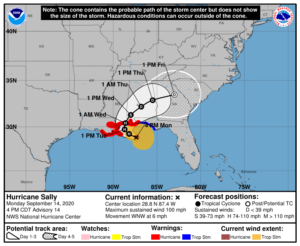
Sally, intensifying to a category one hurricane earlier today, continues to move away from the State of Florida towards a likely landfall in eastern Louisiana or Mississippi sometime late on Tuesday or early on Wednesday. Tropical Storm Warnings remain for the western Florida panhandle and a Hurricane Warning is now in effect for extreme western Florida panhandle..
SUMMARY OF 0500 PM CDT…2100 UTC…INFORMATION
LOCATION…28.8N 87.4W
ABOUT 105 MI…170 KM E OF THE MOUTH OF THE MISSISSIPPI RIVER
ABOUT 145 MI…230 KM SE OF BILOXI MISSISSIPPI
MAXIMUM SUSTAINED WINDS…100 MPH…155 KM/H
PRESENT MOVEMENT…WNW OR 300 DEGREES AT 6 MPH…9 KM/H
MINIMUM CENTRAL PRESSURE…987 MB…29.15 INCHES
SUMMARY OF WATCHES AND WARNINGS IN EFFECT:
A Storm Surge Warning is in effect for…
* Port Fourchon Louisiana to the Okaloosa/Walton County Line Florida
* Lake Pontchartrain, Lake Maurepas, and Lake Borgne
* Mobile Bay
A Hurricane Warning is in effect for…
* Morgan City Louisiana to the Navarre Florida
* Lake Pontchartrain and Lake Maurepas including metropolitan New Orleans
A Tropical Storm Warning is in effect for…
* East of of Navarre Florida to Indian Pass Florida
DISCUSSION:
The following excerpts are from the Forecast Discussion issued at 1700 EDT today, “After the rapid spin up of the inner core late this morning, the most recent aircraft passes through the center have not found any higher flight-level winds, however there have been a few SFMR winds
of 85-90 kt reported. Using a blend of the flight-level and SFMR winds the initial intensity has been increased to 85 kt for this advisory. The next Air Force and NOAA aircraft have begun to sample the storm. Now that Sally has developed an inner core, the favorable atmospheric and ocean conditions of low vertical wind shear and warm water should allow for additional strengthening tonight while the system moves over the north-central Gulf of Mexico, and Sally could approach major hurricane strength. On Tuesday, the global models are predicting an increasing in
southwesterly flow aloft, and this increase in shear, the potential for land interaction, and some upwelling over the shallower shelf waters over the northern Gulf should slow the intensification process. The NHC intensity forecast is again near the upper-end of the guidance envelope in best agreement with the HWRF and HFIP corrected consensus models. Sally did not move much earlier today as the center re-formation took place, but it appears that a slow west-northwestward to northwestward motion has resumed. Weak ridging over the southeastern United States is expected to steer Sally generally west-northwestward through early Tuesday. After that time, steering currents weaken and a slow northward motion is forecast as a weak mid-level trough develops over the the central United States. This trough is forecast to slide eastward, allowing Sally to begin a slow north-northeastward or northeastward motion. The specific timing and location of the turn will be critical as to the eventual
location and timing of landfall along the north-central Gulf Coast. The UKMET and ECMWF models show a more northeastward motion after
the turn and have trended eastward, with the ECMWF much slower than the remainder of the guidance. The NHC track has been adjusted
eastward, and this requires and eastward extension of the hurricane warning. The new track most closely follows the GFS and it ensemble
mean, but lies to the west of the various consensus aids, so some additional eastward adjustments could be needed in subsequent advisories.
Given the uncertainty in the timing and location of the northward turn and the lack of well-defined steering currents, users are reminded to not focus on the exact forecast track or the specific timing and location of landfall. Hurricane-force winds, dangerous storm surge, and flooding rainfall will affect a large portion of the north-central Gulf Coast during the next few days.”
SITUATION AND ACTIONS:
A Tropical Storm Warning is in effect for the coastal portions of Gulf, Bay, southern part of Walton and Okaloosa Counties. A Hurricane Warning is in effect for the southern parts of Santa Rosa and Escambia Counties. The Tropical Storm Watch for coastal Franklin County was discontinued. The only warnings in effect for the ARRL West Central Florida Section are Flood Warnings in effect for portions of the Peace River in Polk County near Bartow, the Myakka River at Myakka River State Park in Sarasota County, and Cypress Creek at State Road 54 Worthington Gardens which will affect Pasco County. The Flood Watch that had been in effect for the entire Ruskin CWA for the last several days was allowed to expire.
At the present time, the primary threat to the ARRL West Central Florida Section continues to be the potential for flooding from any further rainfall. Rain chances will remain elevated for This threat will continue to diminish as Hurricane Sally moves away from the State of Florida. Everyone should continue monitoring the latest advisories issued four times a day by the National Hurricane Center and for any further watches and or warnings issued by the National Weather Service office in Ruskin.
If Hurricane Sally continues its present course away from Florida, these bulletins will be discontinued most likely after tomorrow, being the threat to the State of Florida will be diminished.
LATEST NATIONAL HURRICANE CENTER INFORMATION:
Public Advisories: https://www.nhc.noaa.gov/text/refresh/MIATCPAT4+shtml/120243.shtml?
Forecast Advisory: https://www.nhc.noaa.gov/text/refresh/MIATCMAT4+shtml/120242.shtml?
Forecast Discussion: https://www.nhc.noaa.gov/text/refresh/MIATCDAT4+shtml/120243.shtml?
The next WCF SECTION SPECIAL BULLETIN on Hurricane Sally will issued following the 1700 EDT advisory tomorrow for Hurricane Sally, unless conditions warrant a release sooner.
