WCF SECTION SPECIAL BULLETIN #24-13 – 1800 EDT – 10/09/24
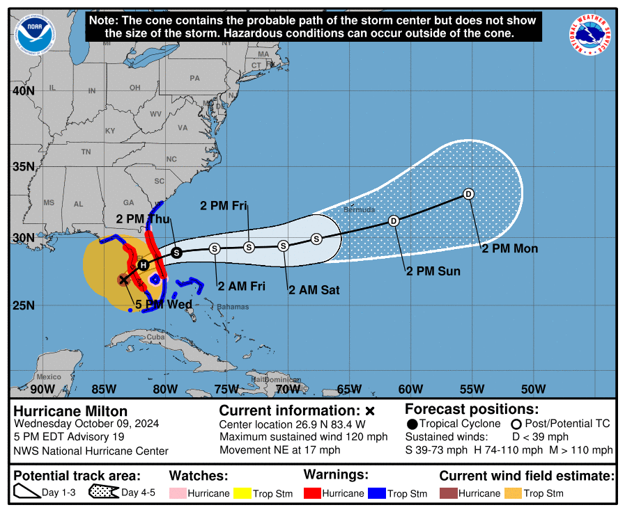
HURRICANE MILTON – 1800 EDT – 10/09/24
Hurricane Milton is now moving at 17 MPH in forward speed and has weakened to a Category 3 hurricane with maximum sustained winds of 120 MPH. The center of Milton is now 60 miles southwest of Sarasota and is expected to make landfall near Bradenton later this evening. An approaching front with its preceding trough will continue to determine the final path of Milton and is now wrapped around the north and west side of Milton. Milton is expected to cross the Florida peninsula in the overnight hours and expected to exit the east coast tomorrow morning by way of Brevard County. Even with the weakening of Milton, it is still a dangerous storm and not to be taken for granted. We have a long night ahead of us in many respects.
COASTAL WATCHES/WARNINGS AND FORECAST CONE FOR STORM CENTER
SUMMARY OF 1700 EST…2100 UTC…INFORMATION
——————————————————————————-
LOCATION…26.9N 83.4W
ABOUT 60 MI…100 KM WSW OF SARASOTA FLORIDA
ABOUT 170 MI…275 KM SW OF ORLANDO FLORIDA
MAXIMUM SUSTAINED WINDS…120 MPH…195 KM/H
PRESENT MOVEMENT…NE OR 35 DEGREES AT 17 MPH…28 KM/H
MINIMUM CENTRAL PRESSURE…948 MB…28.00 INCHES
SUMMARY OF WATCHES AND WARNINGS IN EFFECT:
SUMMARY OF WATCHES AND WARNINGS IN EFFECT:
A Storm Surge Warning is in effect for…
* Florida west coast from Flamingo northward to Yankeetown, including Charlotte Harbor and Tampa Bay
* Sebastian Inlet Florida to Altamaha Sound Georgia, including the St. Johns River
A Hurricane Warning is in effect for…
* Florida west coast from Bonita Beach northward to Suwannee River, including Tampa Bay
* Florida east coast from the St. Lucie/Martin County Line northward to Ponte Vedra Beach
A Hurricane Watch is in effect for…
* Lake Okeechobee
* Florida east coast from the St. Lucie/Martin County Line to the Palm Beach/Martin County Line
A Tropical Storm Warning is in effect for…
* Florida Keys, including Dry Tortugas and Florida Bay
* Lake Okeechobee
* Florida west coast from Flamingo to south of Bonita Beach
* Florida west coast from north of Suwanee River to Indian Pass
* Florida east coast south of the St. Lucie/Martin County Line to Flamingo
* North of Ponte Vedra Beach Florida to Edisto Beach South Carolina
* Extreme northwestern Bahamas, including Grand Bahama Island, the Abacos, and Bimini
A Storm Surge Warning means there is a danger of life-threatening inundation, from rising water moving inland from the coastline, during the next 36 hours in the indicated locations. For a depiction of areas at risk, please see the National Weather
Service Storm Surge Watch/Warning Graphic, available at hurricanes.gov. This is a life-threatening situation. Persons located within these areas should take all necessary actions to protect life and property from rising water and the potential for other dangerous conditions. Promptly follow evacuation and other instructions from local officials.
A Hurricane Warning means that hurricane conditions are expected somewhere within the warning area.
A Tropical Storm Warning means that tropical storm conditions are expected somewhere within the warning area within 36 hours.
A Hurricane Watch means that hurricane conditions are possible within the watch area.
For storm information specific to your area in the United States, including possible inland watches and warnings, please monitor products issued by your local National Weather Service forecast office. For storm information specific to your area outside of the United States, please monitor products issued by your national meteorological service.
FORECAST DISCUSSION:
The Air Force Reserve Hurricane Hunters found that Milton’s central pressure had fallen to 923 mb in the last pass they made through the eye a few hours ago. The satellite presentation has improved since that time, with a thick ring of cold cloud tops surrounding a 10-mile-wide eye. This pattern yielded a T7.0/140 kt from TAFB, with several of the objective satellite estimates between 140 and 145 kt. Milton has again become a category 5 hurricane, with maximum winds estimated to be 145 kt. Another Air Force mission is
entering Milton as we speak.
Milton wobbled a bit to the southeast today, but the longer-term 12-hour motion is east-northeastward (075/8 kt). Milton is forecast to turn northeastward and begin accelerating later today as it moves between a trough digging into the Gulf of Mexico and a ridge near the Greater Antilles. Because of the wobble, the track guidance has been initialized a bit to the south of where many of the raw model fields think the hurricane was centered at 1800 UTC, and this has caused the entire guidance envelope to shift a bit south on this cycle. It is still critical to remember that even at 36 hours (around the time of potential landfall), NHC’s track forecasts can be off by an average of 60 n mi, which means we still can’t pinpoint an exact landfall location, especially if additional wobbles occur in the short term. After landfall, Milton is forecast to cross Florida and emerge over the Atlantic waters on
Thursday.
Milton is expected to maintain major hurricane strength while it moves across the Gulf of Mexico and approaches the west coast of Florida. Stronger vertical shear is expected to increase in about 24 hours, but even if this causes some weakening, it will likely not be enough to keep Milton from being an extremely dangerous hurricane when it reaches shore. Additionally, the first stages of extratropical transition may be just underway as Milton is reaching the coast, which could impart some baroclinic energy and slow the rate of weakening. The NHC intensity forecast is close to the top end of the model envelope, which includes the GFS and ECMWF models, since these models should have a better handle on a potential positive trough interaction.
Milton’s wind field is expected to expand as it approaches Florida. In fact, the official forecast shows the hurricane and tropical-storm-force winds roughly doubling in size by the time it makes landfall. In addition, the stronger-than-normal winds could occur on the northwest/back side of the storm since Milton will be interacting with a frontal boundary and beginning extratropical transition. Damaging winds, life-threatening storm surge, and heavy rainfall will extend well outside the forecast cone. This is a very serious situation and residents in Florida should closely follow orders from their local emergency management officials. Evacuations and other preparations should be completed today.
Milton has the potential to be one of the most destructive hurricanes on record for west-central Florida.
SITUATION AND ACTIONS:
The ARRL West Central Florida Section now has the following watches and warnings in effect:
- Hurricane Warning until further notice: Charlotte, Desoto, Hardee, Highlands, Hillsborough, Pasco, Pinellas, Polk, and Sarasota Counties.
- Storm Surge Warning until further notice: Coastal Pasco, Pinellas, Coastal Hillsborough, Coastal Manatee, Coastal Sarasota, and Coastal Charlotte Counties.
- Flood Watch through Thursday morning.
- Tornado Watch remains in effect until 2100 EDT for Pasco, Pinellas, Hillsborough, Manatee, and Sarasota Counties. The other counties in the ARRL West Central Florida Section were in the Tornado Watch but were allowed to expire.
- Numerous Flood Warnings have been in effect, mostly for various river and areas near these rivers since earlier in the day.
The Section ARES Alert Level is currently at a Level 1. All ARES Groups that are tasked with doing response have been deployed. The latest status can be found on the main page of the Section website under the “ARRL West Central Florida Section ARES Alert Status.
A Regional SKWYARN Net is now in progress on the NI4CE Analog and NI4CE NXDN Systems (talkgroup 1299), and has been since approximately 1200 EDT today.
All ARES, ACS, and CERT personnel should have completed all personal preparations and should be shelted in secure locations at this time.
All ARES, ACS, and CERT personnel are encouraged to continue to check the Tropical Weather Outlook issued four times daily by the National Hurricane Center. Currently there are two other tropical storms out in the Atlantic, which do not threaten the continental United States. However, this can change rapidly, so vigilance is the order of hurricane season.
LATEST NATIONAL HURRICANE CENTER INFORMATION:
Public Advisories: https://www.nhc.noaa.gov/text/refresh/MIATCPAT4+shtml/062052.shtml?
Forecast Advisory: https://www.nhc.noaa.gov/text/refresh/MIATCMAT4+shtml/062051.shtml?
Forecast Discussion: https://www.nhc.noaa.gov/text/refresh/MIATCDAT4+shtml/062053.shtml?
Latest GOES Satellite Floater Images and Loop: https://www.star.nesdis.noaa.gov/GOES/floater.php?stormid=AL142024#navLink
CONCLUSION
The next WCF SECTION SPECIAL BULLETIN will be issued around 2000 EDT tomorrow evening or sooner if conditions warrant.