WCF SECTION SPECIAL BULLETIN #24-11 – 2000 EDT – 10/07/24
HURRICANE MILTON – 2000 EDT – 10/07/24
Hurricane Milton has gone from a Category 1 to a Category 5 hurricane since our last special bulletin yesterday. What is unprecedented is that the maximum sustained winds of 180 MPH and a barometric pressure of 26.97 inches!! Milton will eventually turn towards the northeast and head for the Florida west coast, as an approaching front with its preceding trough will determine the final path of Milton. That cold front and trough will increase the wind shear across Milton and some drier air will get drawn into Milton, lowering its intensity somewhat before landfall on the Florida west coastal, which for right now is in the Tampa area. In spite of this, Milton is still a dangerous storm and not to be taken for granted.
COASTAL WATCHES/WARNINGS AND FORECAST CONE FOR STORM CENTER
SUMMARY OF 2000 EST…0000 UTC…INFORMATION
——————————————————————————-
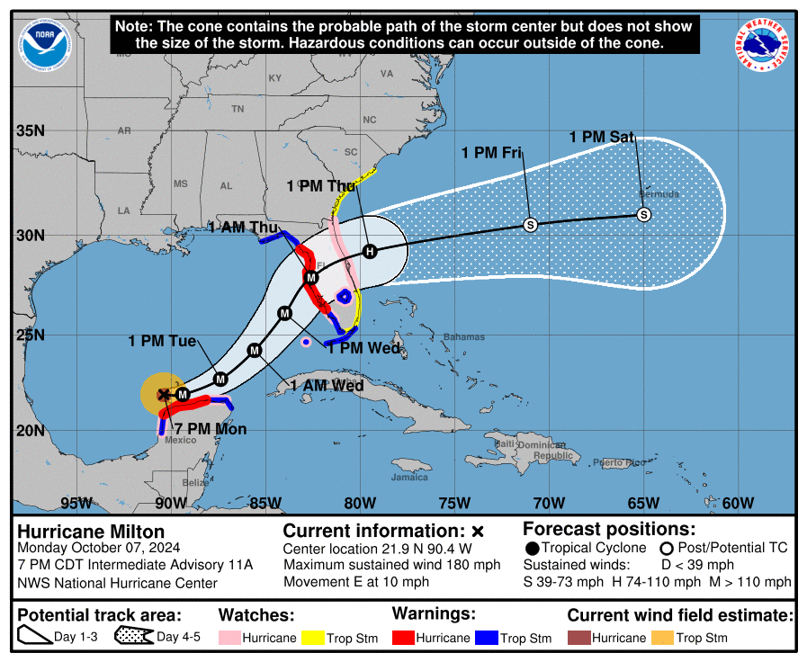
LOCATION…21.9N 90.4W
ABOUT 60 MI…100 KM NW OF PROGRESO MEXICO
ABOUT 650 MI…1045 KM SW OF TAMPA FLORIDA
MAXIMUM SUSTAINED WINDS…180 MPH…285 KM/H
PRESENT MOVEMENT…E OR 90 DEGREES AT 10 MPH…17 KM/H
MINIMUM CENTRAL PRESSURE…897 MB…26.49 INCHES
SUMMARY OF WATCHES AND WARNINGS IN EFFECT:
SUMMARY OF WATCHES AND WARNINGS IN EFFECT:
A Storm Surge Warning is in effect for…
* West coast of Florida from Flamingo northward to the Suwannee River, including Charlotte Harbor and Tampa Bay
A Hurricane Warning is in effect for…
* Celestun to Rio Lagartos
* Florida west coast from Bonita Beach northward to the mouth of the Suwannee River, including Tampa Bay
A Storm Surge Watch is in effect for…
* Sebastian Inlet to Edisto Beach, including St. Johns River
A Hurricane Watch is in effect for…
* Rio Lagartos to Cabo Catoche
* Campeche to south of Celestun
* Dry Tortugas
* Lake Okeechobee
* Florida west coast from Chokoloskee to south of Bonita Beach
* Florida east coast from the St. Lucie/Indian River County Line
northward to the mouth of the St. Marys River
A Tropical Storm Warning is in effect for…
* Rio Lagartos to Cancun
* Campeche to south of Celestun
* All of the Florida Keys, including Dry Tortugas
* Lake Okeechobee
* Florida west coast from Flamingo to south of Bonita Beach
* Florida west coast from north of the mouth of the Suwanee River to Indian Pass
A Tropical Storm Watch is in effect for…
* East coast of the Florida Peninsula south of the St. Lucie/Indian River County Line southward to Flamingo
* Coast of Georgia and South Carolina from north of the mouth of the St. Marys River to South Santee River, South Carolina
A Storm Surge Warning means there is a danger of life-threatening inundation, from rising water moving inland from the coastline, during the next 36 hours in the indicated locations. For a depiction of areas at risk, please see the National Weather Service Storm Surge Watch/Warning Graphic, available at hurricanes.gov. This is a life-threatening situation. Persons located within these areas should take all necessary actions to protect life and property from rising water and the potential for other dangerous conditions. Promptly follow evacuation and other instructions from local officials.
A Hurricane Warning means that hurricane conditions are expected somewhere within the warning area. A warning is typically issued 36 hours before the anticipated first occurrence of tropical-storm-force winds, conditions that make outside preparations difficult or dangerous. Preparations to protect life and property should be rushed to completion.
A Tropical Storm Warning means that tropical storm conditions are expected somewhere within the warning area within 36 hours.
A Storm Surge Watch means there is a possibility of life-threatening inundation, from rising water moving inland from the coastline, in the indicated locations during the next 48 hours. For a depiction of areas at risk, please see the National Weather Service Storm Surge Watch/Warning Graphic, available at hurricanes.gov.
A Hurricane Watch means that hurricane conditions are possible within the watch area. A watch is typically issued 48 hours before the anticipated first occurrence of tropical-storm-force winds, conditions that make outside preparations difficult or dangerous.
A Tropical Storm Watch means that tropical storm conditions are possible within the watch area, generally within 48 hours.
Interests in the remainder of Florida and the northwestern Bahamas should monitor the progress of this system.
FORECAST DISCUSSION:
The following excerpt is from the Forecast Discussion issued at 1700 EDT today:
Milton is rapidly intensifying. Satellite images indicate very deep convection in the eyewall and hints of an eye starting to appear. The last fix from the aircraft showed that the central pressure was down to 985 mb, about 3 mb less than 80 minutes prior, and winds supporting 70 kt at the surface. Since that time, satellite images continue to show further organization, and the initial wind speed is set to 75 kt.
Milton is moving just south of due east at about 6 kt. This equatorward motion has been more than expected probably due to a stronger low/ mid-level frontal low over the northeastern Gulf of Mexico. The frontal feature is forecast to weaken while it moves across Florida and gradually lose its influence on Milton. This evolution should allow the hurricane to turn eastward on Monday and then accelerate to the northeast on Tuesday and Wednesday toward the Florida Peninsula ahead of a trough moving offshore of Texas. The NHC forecast is a bit south of the previous one through 48 hours, following the trend of the guidance at that time, and the government of Mexico has issued a Hurricane Watch for a portion of the northern coast of Yucatan. Later on, the guidance is similar to, or slightly north of the last cycle, and very little change is made to the forecast near Florida. It should be noted that the average NHC track error at day 3 is around 100 miles, and users should not focus on the exact track.
The intensity forecast appears straightforward at first, with rapid intensification likely while the small hurricane remains within light shear and over very deep warm waters. Intensity guidance is about as bullish as I’ve seen in this part of the basin, with almost everything showing a peak intensity of category 4 or 5 in the southern Gulf of Mexico in a day or two. The NHC forecast is raised from the previous one and lies near the intensity consensus
model and still could be too low. Later on, vertical wind shear is forecast to markedly increase as Milton approaches Florida, and some weakening is anticipated. However, the regional hurricane models are showing the system growing even if it weakens, and we are
expecting Milton to be a large hurricane at landfall, with very dangerous impacts spread out over a big area. There is increasing confidence that a powerful hurricane with life- threatening hazards will be affecting portions of the Florida west coast around the middle of this week. Residents there should closely monitor this system and listen to local officials.
SITUATION AND ACTIONS:
The ARRL West Central Florida Section now has the following watches and warnings in effect:
- Hurricane Warning until further notice: Charlotte, Desoto, Hardee, Highlands, Hillsborough, Pasco, Pinellas, Polk, and Sarasota Counties.
- Storm Surge Warning until further notice: Coastal Pasco, Pinellas, Coastal Hillsborough, Coastal Manatee, Coastal Sarasota, and Coastal Charlotte Counties.
- Flood Watch through Thursday morning.
As of press time, we have the following information on ARES groups activations. The following ARES groups are to active tomorrow morning, Tuesday 10/08/24: Charlotte County ARES, Hillsborough County ARES/RACES, and Pinellas County ARES/ACS. The following ARES groups are to active on Wednesday morning 10/09/24: Hardee County ARES and Highlands County ARES.
Commensurate with the activations tomorrow, the Section ARES Alert Level will be raised to a Level 2 alert, which is a partial activation. Then when all ARES groups available activate, the ARES Alert Level will go to a Leve1 alert, which is a full activation. This is subject to change on a moments notice. The latest status can be found on the main page of the Section website under the “ARRL West Central Florida Section ARES Alert Status.
A Regional SKWYARN Net will be held on the NI4CE Analog and NI4CE NXDN Systems (talkgroup 1299) once the landfall of Milton gets closer.
All ARES, ACS, and CERT personnel are encouraged to rush to completion any personal preparations that have not been completed.
All ARES, ACS, and CERT personnel are encouraged to continue to check the Tropical Weather Outlook issued four times daily by the National Hurricane Center. Currently there are two other tropical storms out in the Atlantic, which do not threaten the continental United States. However, this can change rapidly, so vigilance is the order of hurricane season.
LATEST NATIONAL HURRICANE CENTER INFORMATION:
Public Advisories: https://www.nhc.noaa.gov/text/refresh/MIATCPAT4+shtml/062052.shtml?
Forecast Advisory: https://www.nhc.noaa.gov/text/refresh/MIATCMAT4+shtml/062051.shtml?
Forecast Discussion: https://www.nhc.noaa.gov/text/refresh/MIATCDAT4+shtml/062053.shtml?
Latest GOES Satellite Floater Images and Loop: https://www.star.nesdis.noaa.gov/GOES/floater.php?stormid=AL142024#navLink
CONCLUSION
The next WCF SECTION SPECIAL BULLETIN will be issued around 2000 EDT tomorrow evening or sooner if conditions warrant.