WCF SECTION SPECIAL BULLETIN #24-10 – 2000 EDT – 10/06/24
HURRICANE MILTON – 2000 EDT – 10/06/24
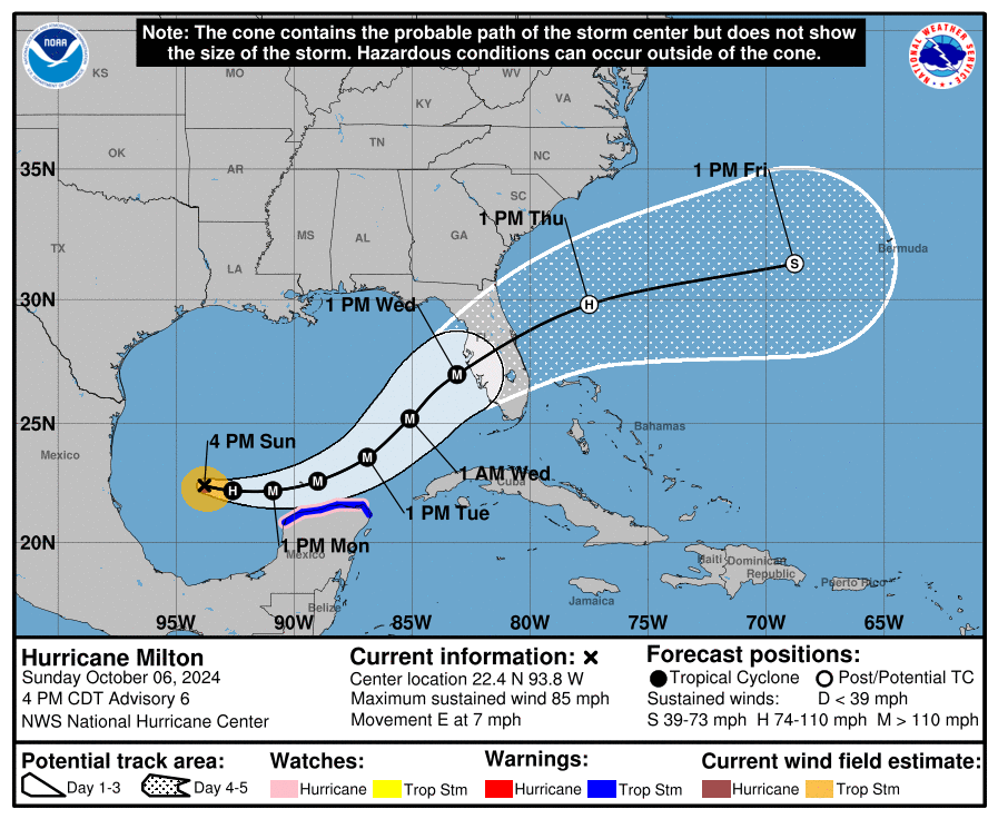
The disturbance that was located in the western Caribbean for the last week finally emerged into the Gulf of Mexico over the weekend. The National Hurricane Center begin issuing advisories on Tropical Depression Fourteen on Saturday morning, being updated quickly to Tropical Storm Milton by Saturday afternoon. This morning the National Hurricane Center declared Milton a Category 1 hurricane. Milton, is being steered to the east by a low pressure system. Milton is expected to continue east and then turn northeast towards a landfall on the Florida west coast on Wednesday afternoon to early evening. The approaching front with its preceding trough will determine the final path of Milton. With this latest tropical threat to Florida, WCF SECTION SPECIAL BULLETINS on Milton are now being commenced.
COASTAL WATCHES/WARNINGS AND FORECAST CONE FOR STORM CENTER
SUMMARY OF 2000 EST…0000 UTC…INFORMATION
——————————————————————————-
LOCATION…22.5N 93.4W
ABOUT 250 MI…405 KM WNW OF PROGRESO MEXICO
ABOUT 780 MI…1255 KM WSW OF TAMPA FLORIDA
MAXIMUM SUSTAINED WINDS…85 MPH…140 KM/H
PRESENT MOVEMENT…E OR 100 DEGREES AT 7 MPH…11 KM/H
MINIMUM CENTRAL PRESSURE…981 MB…28.97 INCHES
SUMMARY OF WATCHES AND WARNINGS IN EFFECT:
SUMMARY OF WATCHES AND WARNINGS IN EFFECT:
A Hurricane Watch is in effect for…
* Celestun to Cabo Catoche
A Tropical Storm Warning is in effect for…
* Celestun to Cancun
A Hurricane Watch means that hurricane conditions are possible within the watch area. A watch is typically issued 48 hours before the anticipated first occurrence of tropical-storm-force winds, conditions that make outside preparations difficult or dangerous.
A Tropical Storm Warning means that tropical storm conditions are expected somewhere within the warning area within 36 hours.
Interests in the remainder of the Yucatan peninsula of Mexico, the Florida Peninsula, the Florida Keys, and the northwestern Bahamas should monitor the progress of this system.
Storm Surge and Hurricane Watches will likely be issued for portions of Florida early Monday.
FORECAST DISCUSSION:
The following excerpt is from the Forecast Discussion issued at 1700 EDT today:
Milton is rapidly intensifying. Satellite images indicate very deep convection in the eyewall and hints of an eye starting to appear. The last fix from the aircraft showed that the central pressure was down to 985 mb, about 3 mb less than 80 minutes prior, and winds supporting 70 kt at the surface. Since that time, satellite images continue to show further organization, and the initial wind speed is set to 75 kt.
Milton is moving just south of due east at about 6 kt. This equatorward motion has been more than expected probably due to a stronger low/ mid-level frontal low over the northeastern Gulf of Mexico. The frontal feature is forecast to weaken while it moves across Florida and gradually lose its influence on Milton. This evolution should allow the hurricane to turn eastward on Monday and then accelerate to the northeast on Tuesday and Wednesday toward the Florida Peninsula ahead of a trough moving offshore of Texas. The NHC forecast is a bit south of the previous one through 48 hours, following the trend of the guidance at that time, and the government of Mexico has issued a Hurricane Watch for a portion of the northern coast of Yucatan. Later on, the guidance is similar to, or slightly north of the last cycle, and very little change is made to the forecast near Florida. It should be noted that the average NHC track error at day 3 is around 100 miles, and users should not focus on the exact track.
The intensity forecast appears straightforward at first, with rapid intensification likely while the small hurricane remains within light shear and over very deep warm waters. Intensity guidance is about as bullish as I’ve seen in this part of the basin, with almost everything showing a peak intensity of category 4 or 5 in the southern Gulf of Mexico in a day or two. The NHC forecast is raised from the previous one and lies near the intensity consensus
model and still could be too low. Later on, vertical wind shear is forecast to markedly increase as Milton approaches Florida, and some weakening is anticipated. However, the regional hurricane models are showing the system growing even if it weakens, and we are
expecting Milton to be a large hurricane at landfall, with very dangerous impacts spread out over a big area. There is increasing confidence that a powerful hurricane with life- threatening hazards will be affecting portions of the Florida west coast around the middle of this week. Residents there should closely monitor this system and listen to local officials.
SITUATION AND ACTIONS:
Hillsborough County ARES has been requested to active for staffing shelters on Monday 10/07/24. Other ARES groups are on stand by to be deployed as well. The ARRL West Central Florida Section went to a ARES Alert Level 3 at 0920 in response to this activation and other anticipated activation.
A Regional SKWYARN Net will be held on the NI4CE Analog and NI4CE NXDN Systems (talkgroup 1299) once the landfall of Milton gets closer.
All ARES, ACS, and CERT personnel are encouraged to rush to completion any personal preparations that have not been completed.
All ARES, ACS, and CERT personnel are encouraged to continue to check the Tropical Weather Outlook issued four times daily by the National Hurricane Center. Currently there are two other tropical storms out in the Atlantic, which do not threaten the continental United States. However, this can change rapidly, so vigilance is the order of hurricane season.
LATEST NATIONAL HURRICANE CENTER INFORMATION:
Public Advisories: https://www.nhc.noaa.gov/text/refresh/MIATCPAT4+shtml/062052.shtml?
Forecast Advisory: https://www.nhc.noaa.gov/text/refresh/MIATCMAT4+shtml/062051.shtml?
Forecast Discussion: https://www.nhc.noaa.gov/text/refresh/MIATCDAT4+shtml/062053.shtml?
Latest GOES Satellite Floater Images and Loop: https://www.star.nesdis.noaa.gov/GOES/floater.php?stormid=AL142024#navLink
CONCLUSION
The next WCF SECTION SPECIAL BULLETIN will be issued around 2000 EDT tomorrow evening or sooner if conditions warrant.