WCF SECTION SPECIAL BULLETIN #22-05 – 2100 EDT – 6/04/22
POTENTIAL TROPICAL CYCLONE #1 – 2000 EDT – 6/04/22
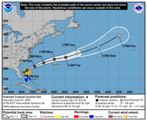
At 800 PM EDT (0000 UTC), the disturbance was centered near latitude 28.3 North, longitude 78.9 West. The system is moving toward the northeast near 18 mph (30 km/h), and this general motion is expected to continue through tonight. A turn toward the east-northeast with an additional increase in forward speed is expected on Sunday, followed by a turn toward the east Monday night. On the forecast track, the disturbance is expected to move farther away from the
east coast of Florida and over the southwestern Atlantic north of the Bahamas tonight, and move near or to the north of Bermuda on Monday.
Maximum sustained winds remain near 45 mph (75 km/h) with higher gusts. The disturbance is expected to become a tropical or subtropical storm tonight or Sunday, and some strengthening is possible through Monday.
* Formation chance through 48 hours…high…90 percent.
* Formation chance through 5 days… high…90 percent.
Tropical-storm-force winds extend outward up to 210 miles (335 km) to the east of the center. A weather station at Settlement Point on Grand Bahama Island recently reported a wind gust of 36 mph (57 km/h).
The estimated minimum central pressure based on surface observations is 999 mb (29.50 inches).
COASTAL WATCHES/WARNINGS AND FORECAST CONE FOR STORM CENTER
SUMMARY OF 0800 PM EDT…0000 UTC…INFORMATION
LOCATION…28.3N 78.9W
ABOUT 105 MI…185 KM NE OF FORT PIERCE FLORIDA
ABOUT 885 MI…1425 KM WSW OF BERMUDA
MAXIMUM SUSTAINED WINDS…45 MPH…75 KM/H
PRESENT MOVEMENT…NE OR 50 DEGREES AT 18 MPH…30 KM/H
MINIMUM CENTRAL PRESSURE…999 MB…29.50 INCHES
SUMMARY OF WATCHES AND WARNINGS IN EFFECT:
SUMMARY OF WATCHES AND WARNINGS IN EFFECT…
A TROPICAL STORM WARNING IS IN EFFECT FOR…
* NORTHWESTERN BAHAMAS
A TROPICAL STORM WATCH IS IN EFFECT FOR…
* BERMUDA
FORECAST DISCUSSION:
The following excerpt is from the Forecast Discussion issued at 1700 EDT today:
“Radar data and surface observations indicate that the circulation of the disturbance has become a little better defined since the last advisory, although the central area still consists of an area of multiple vorticity maxima extending from near Lake Okeechobee east-northeastward into the Atlantic. While the current structure still does not justify an upgrade to a tropical storm, the easternmost of these centers is near the main convective area, and if this continues the system could become a tropical storm in the next 6-12 hours. An earlier Air Force Reserve Hurricane Hunter mission reported a large area of 50-kt winds at 3000 ft, and believable SFMR surface wind estimates of 35-40 kt. Based on these data, the initial intensity is increased to 40 kt.
The initial motion is 050/16, and some of this is due to the ongoing re-formations of the center. The track guidance remains in good agreement that a general northeastward motion should continue through Sunday, followed by an east-northeastward to eastward motion Monday and Tuesday. On the forecast track, the system will move away from Florida tonight, and then pass north of Bermuda on Monday on its way into the central Atlantic.
Water vapor and air mass imagery show a mid- to upper-level trough over the southeastern United States and the eastern Gulf of Mexico. While this trough continues to aid strong westerly shear over the disturbance, the interaction between this trough and the disturbance is forecast to lead to a better-defined circulation
during the next 12-24 h, which should allow the disturbance to become a tropical storm and strengthen a little. The long-term forecast for the system has gotten murkier. After about 60-72 h, several of the global models essentially split the system in two, with a center that forms in the northern part of the circulation merging with a frontal system to become an extratropical low, while the rest of the system turns more southward and slows down well to
the east of Bermuda. Given the uncertainty, there will be no changes at this time from the previous forecast of extratropical transition and the associated track forecast. However, there is now an alternate scenario that may require changes to the track and intensity forecasts in later advisories.”
SITUATION AND ACTIONS:
All watches and warnings for the ARRL West Central Florida Section were dropped this morning and for the rest of the State of Florida this afternoon.
To our knowledge, there had not been any requests for services from any of the ARES groups in the ten counties in the ARRL West Central Florida Section.
Note: The Section ARES Alert Level simply reflects the activation status of local ARES groups in the ARRL West Central Florida Section. Each ARES groups activates at the request of their served agencies and or in accordance with their local ARES plan.
All ARES, ACS, and CERT personnel are encouraged to continue to check each advisory issued by the National Hurricane Center in Miami and the Tropical Weather Outlook issued four times daily by the National Hurricane Center.
LATEST NATIONAL HURRICANE CENTER INFORMATION:
Public Advisories: https://www.nhc.noaa.gov/text/refresh/MIATCPAT1+shtml/022334.shtml?
Forecast Advisory: https://www.nhc.noaa.gov/text/refresh/MIATCMAT1+shtml/022052.shtml
Forecast Discussion: https://www.nhc.noaa.gov/text/refresh/MIATCDAT1+shtml/022057.shtml
Latest NWS Rusking Hurricane Local Statement: https://www.nhc.noaa.gov/text/WTUS82-KTBW.shtml
CONCLUSION
This will be the last WCF SECTION SPECIAL BULLETIN on Potential Tropical Cyclone #1.
