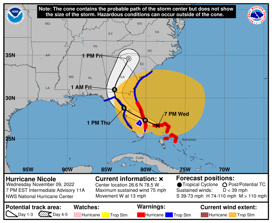
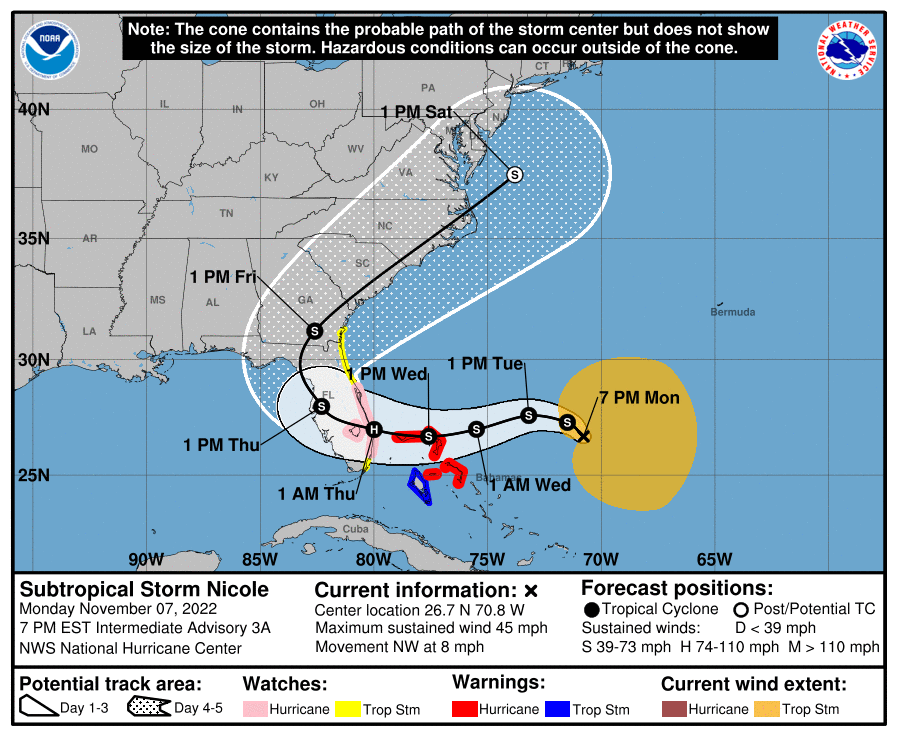
WCF SECTION PRESS RELEASE #21-43

ARRL WEST CENTRAL FLORIDA SECTION ARES PARTICIPATING IN ARRL SIMULATED EMERGENCY TEST.

The ARRL Simulated Emergency Test is set for this coming weekend, Saturday October 2, 2021 and Sunday October 3, 2021.   The ARRL West Central Florida Section is planning a the ARRL West Central Florida Section Simulated Emergency Test to run in conjunction with the national ARRL Simulated Emergency Test (SET) on Saturday October 2, 2021 from 0900 through 1200 EDT.  The purpose of this SET as stated in the SET planning document is “To test HF and VHF/UHF communications between the Emergency Operations Centers (EOCs) in the above listed counties and any others wishing to participate in the exercise.  We also welcome any amateurs operating from home or portable/mobile stations.”

To view the planning document and any other related documents to the SET, you may go to the West Central Florida Section Simulated Emergency Test webpage, located on the Section website at http://arrlwcf.org/wcf-special-events/west-central-florida-section-ares-simulated-emergency-test/.

END OF PRESS RELEASE

WCF SECTION PRESS RELEASE #21-42

UPCOMING SKYWARN TRAINING OPPORTUNITIES FOR FALL 2021

The National Weather Service Office in Ruskin has announced on the NWS Ruskin SKYWARN a couple of SKYWARN training opportunities for the Fall of 2021.  At the present time, the National Weather Service Office in Ruskin is only conducting SKYWARN training classes in virtual format.  The following virtual SKYWARN training classes have been scheduled:

Wednesday, September 29th, 2021 from 1300-1400 EDT.  Please register at https://attendee.gotowebinar.com/register/8917568584034608144.

Wednesday, October 20th, 2021 from 1300-1400 EDT.  Please register at https://attendee.gotowebinar.com/register/3217792664681561867.

There is available on the National Weather Service Office Ruskin SKYWARN page, a pre-recorded one hour SKYWARN training class, and links to other SKYWARN training classes that are administered by Spotter Network and Met-Ed.  The hyperlink to the National Weather Service Office SKYWARN page is https://www.weather.gov/tbw/skywarn.

END OF PRESS RELEASE

WCF SECTION PRESS RELEASE #21-41

TAMIAMI AMATEUR RADIO CLUB FOXHUNT 2021 CANCELLED

The Tamiami Amateur Radio Club Foxhunt 2021 that was scheduled for Saturday October 23, 2021, has been cancelled.  The following statement was issued by Paul Nienaber

KN4BAR Event Director for the Tamiami Amateur Radio Club concerning the cancellation, “It is with great regret that we have decided to cancel the October 23rd first annual Tamiami Fox Hunt. A number of factors, not the least of which are lingering concerns over Covid-19, have contributed to this decision. All advance registration fees will be returned in full. If you do not receive your refund by September 24, 2021 please contact the undersigned immediately. We hope to try this event again when conditions are more conducive to having a successful and fun event.

END OF PRESS RELEASE

WCF SECTION PRESS RELEASE #21-40

BIKE MS CITRUS TOUR 2022 DATE SET.  BIKE MS CITRUS TOUR VOLUNTEERS HELPING OUT WITH BIKE MS PGA CYCLE TO THE SHORE IN OCTOBER.

The date for the Bike MS Citrus Tour 2022 has been set for Saturday March 5, 2022 and Sunday March 6, 2022.  The Bike MS Citrus Tour will start and finish both days at the Omni Resort at Champions Gate which is near the Osceola/Polk County line, with over 95 percent of the ride in the northern and eastern portions of Polk County.  The ARRL West Central Florida Section has sponsored the amateur radio communications for the Bike MS Citrus Tour since 2018.  The Bike MS Citrus Tour for 2021 was cancelled due to concerns from COVID-19.  For more information on the Bike MS Citrus Tour or to sign up to volunteer to help with communications, please go to the amateur radio Bike MS Citrus Tour page at https://www.citrustour.org/

A group of veteran Bike MS Citrus Tour volunteers have accepted the invitation to go up to the Northern Florida Section to assist with communications for the Bike MS PGA Tour Cycle To The Shore on Saturday October 23, 2021 and Sunday October 24, 2021. that will run this year from St. Augustine to Daytona Beach near or along the Florida east coast.

END OF PRESS RELEASE

WCF SECTION PRESS RELEASE #21-39

NEW EMERGENCY COORDINATOR APPOINTED FOR PASCO COUNTY

On Tuesday July 27, 2021, Mike Douglas W4MDD, Section Manager of the ARRL West Central Florida Section, appointed Tim Cunningham KM4YGV, to be the new ARRL Emergency Coordinator for Pasco County.  Cunningham succeeds Bill Fetta N7CGC who stepped down as ARRL Emergency Coordinator due to personal reasons.  Fetta had served as ARRL Emergency Coordinator since June 2021.  Fetta has stayed on as an Assistant Emergency Coordinator for Pasco County ARES.

Cunningham was first licensed in the middle of 2016 but had been interested in amateur radio since he was a shortwave listener in the 1970’s.  Cunningham brings experience to the position he had obtained in his professional career as a Firefighter, having been out in the field for many weather events all over the State of Florida.

Cunningham made the following statement about his appointment as ARRL Emergency Coordinator, “My years in the Fire dept offered me boots on the ground experience during most of the big weather events all over Florida and many major fires throughout but as a worker bee, I was never invited into the air-conditioned comfort of the EOC, ICP.  At Pasco County ARES/RACES, I’ve met a strong core of “retired” ARES former ECs and EOC managers that are mentoring me and assisting in building Pasco County ARES/RACES into a premier organization.”

END OF PRESS RELEASE

WCF SECTION PRESS RELEASE #21-38

NEW TROPICAL WEATHER OUTLOOK EMAIL NOTIFICATION LIST UNVEILED


Joe Tomasone AB2M, an ARRL Technical Specialist here in the ARRL West Central Florida Section who created the ARESDB database in 2001 in the aftermath of the September 11, 2001 attacks on the United States, recently announced a new email list to which ARES, ACS, and CERT personnel may subscribe, to receive the National Hurricane Center Tropical Weather Outlook when it is issued four times a day during the Atlantic hurricane season and at other times as warranted.

To subscribe to this new Tropical Weather Outlook email dissemination list, you may sign up at http://lists.aresdb.com/mailman/listinfo/tropicaloutlook.  The ARRL West Central Florida Section extends its sincere thanks to Joe Tomasone AB2M for creating this new service to amateur radio operators and for the continuous service of the ARESDB database for the past 20 years.

END OF PRESS RELEASE

WCF SECTION PRESS RELEASE #21-37

EMERGENCY COORDINATOR REAPPOINTED AND NEW SECTION EMERGENCY COORDINATOR APPOINTED


Christine Duez K4KJN was reappointed as ARRL Emergency Coordinator for Polk County ARES on Wednesday August 4th, 2021.  Duez was reappointed as ARRL Emergency Coordinator due to Mike Shreve N6MRS stepping down as the ARRL Emergency Coordinator due to personal reasons.  Duez had previously served as ARRL Emergency Coordinator for Polk County ARES from July 2020 through May 2021.

Duez was also appointed as Section Emergency Coordinator on Thursday August 5th, 2021, succeeding Norman Xanders WX4NEX, who had been Section Emergency Coordinator since early May 2021.

Mike Douglas W4MDD, Section Manager of the ARRL West Central Florida Section made the following statement concerning this reappointment and appointment, “I reappointed Christine Duez K4KJN, as ARRL Emergency Coordinator of Polk County.  I also appointed Christine as Section Emergency Coordinator to replace Norman Xanders WX4NEX.  I take full responsibility for the way Christine was abruptly removed from the post of EC Polk County and for that I apologize. Christine’s removal should have never happened.  Going forward I will not be pressured into making decisions I have not looked at first.”

END OF PRESS RELEASE

WCF SECTION SPECIAL BULLETIN #21-14 – FINAL – 1800 EDT – 8/14/21

REMNANTS OF FRED – 1800 EDT – 8/14/21

At 1100 EDT today, the National Hurricane Center could not find a closed center of circulation and declared Fred to no longer be a tropical cyclone.  However, they are reasonably confident it will re-obtain tropical cyclone status sometime in the next 24 hours.

At 500 PM EDT (2100 UTC), the remnants of Fred were located near latitude 24.0 North, longitude 84.6 West. The remnants are moving toward the west-northwest near 13 mph (20 km/h). A motion toward the northwest is expected tonight through Sunday night, with a turn toward the north expected on Monday. On the forecast track, the system will cross the southeastern Gulf of Mexico tonight, cross the central and northern Gulf of Mexico Sunday and Monday, and move inland along the northern Gulf coast Monday night.

Maximum sustained winds are near 35 mph (55 km/h) with higher gusts. Fred is expected to re-develop into a tropical depression late tonight or on Sunday, with gradual strengthening to a tropical storm expected after the system re-develops.
* Formation chance through 48 hours…high…90 percent.
* Formation chance through 5 days…high…90 percent.

The estimated minimum central pressure is 1012 mb (29.89 inches).

COASTAL WATCHES/WARNINGS AND FORECAST CONE FOR STORM CENTER

SUMMARY OF 0500 PM EDT…2100 UTC…INFORMATION

LOCATION…24.0N 84.6W
ABOUT 150 MI…240 KM WNW OF HAVANA CUBA
ABOUT 510 MI…820 KM SSE OF MOBILE ALABAMA
MAXIMUM SUSTAINED WINDS…35 MPH…55 KM/H
PRESENT MOVEMENT…WNW OR 300 DEGREES AT 13 MPH…20 KM/H
MINIMUM CENTRAL PRESSURE…1012 MB…29.89 INCHES

SUMMARY OF WATCHES AND WARNINGS IN EFFECT:

There are no coastal watches or warnings in effect.

Interests in the northern coast of the Gulf of Mexico from Mississippi to the central Florida Panhandle should monitor the progress of the remnants of Fred. Watches and warnings could be required for portions of this area tonight or Sunday.

FORECAST DISCUSSION:

The following excerpt is from the Forecast Discussion issued at 1700 EDT today:

“Satellite imagery this afternoon shows that a broad and elongated circulation has formed in association with the remnants of Fred, and that the convection has become more concentrated at the east end of the elongated center. However, neither the circulation nor the convection are organized enough to justify calling the system a tropical cyclone at this time. An Air Force Reserve Hurricane Hunter aircraft is scheduled to survey the remnants of Fred this evening to see how far the re-development has progressed.

The initial motion is a still very uncertain 300/11. The system is expected to move northwestward around the western periphery of the subtropical ridge, with a turn toward the north expected as the system nears and moves inland along the northern Gulf coast in 48-60h. The forecast guidance remains in good agreement on this general scenario and the new NHC forecast track is close the the consensus models. However, some adjustments to the track forecast could occur depending on where the center of Fred re-forms. Therefore, users should not concentrate on the details of the forecast track, which
could change quite a bit during the next day or so.

The global models are now in better agreement that the upper-level trough over the eastern Gulf of Mexico that has been hindering the development of Fred will move northward and weaken during the next 24 h. They also indicate that Fred is likely to re-form a well-defined closed circulation over the eastern Gulf of Mexico Sunday morning. Thus, the intensity forecast now calls for Fred to regain tropical cyclone status in about 12 h, followed by gradual strengthening until landfall in a less than ideal upper-level wind
environment. After landfall, the system should weaken and dissipate between 96-120 h. The new NHC intensity forecast follows the overall trend of the intensity guidance.

Although no coastal watches or warnings are currently in effect, the National Hurricane Center will continue 6-hourly advisories on the remnants of Fred in anticipation of re-development. Watches could be required for portions of the northern Gulf coast tonight,
and warnings may be required on Sunday.”

SITUATION AND ACTIONS:

At this time there are no watches or warnings in effect for the ARRL West Central Florida Section or the entire State of Florida.

Several ARES Groups stood down today from stand by status.  Once final confirmation is received that all ARES groups have stood down, we will return the Section ARES Alert Level to No Alert.  It is possible that some ARES groups may remain at a stand by status due to slowly increasing threat from Tropical Storm Grace.   Note:  The Section ARES Alert Level simply reflects the activation status of local ARES groups in the ARRL West Central Florida Section.  Each ARES groups activates at the request of their served agencies and or in accordance with their local ARES plan.

All ARES, ACS, and CERT personnel are encouraged to continue to check each advisory issued by the National Hurricane Center in Miami and any advisories or Hurricane Local Statements issued by the National Weather Service Office in Ruskin.

LATEST NATIONAL HURRICANE CENTER INFORMATION:

Public Advisories:  https://www.nhc.noaa.gov/text/refresh/MIATCPAT1+shtml/112039.shtml
Forecast Advisory:  https://www.nhc.noaa.gov/text/refresh/MIATCMAT1+shtml/112039.shtml?
Forecast Discussion:  https://www.nhc.noaa.gov/text/refresh/MIATCDAT1+shtml/112040.shtml

CONCLUSION

This will be the last WCF SECTION SPECIAL BULLETIN on the Remnants of Fred, unless the threat to the Florida peninsula significantly increases.

WCF SECTION SPECIAL BULLETINS could commence on Tropical Storm Grace either tomorrow or Monday 8/16/21, depending upon the forecast track.

WCF SECTION SPECIAL BULLETIN #21-13 – 1800 EDT – 8/13/21

TROPICAL DEPRESSION FRED – 1800 EDT – 8/13/21

Since the 1100 EDT advisory earlier today, Tropical Depression Fred was headed nearly west for several hours.  As a result, the forecast track has shifted significantly west, the first real significant shift of the forecast track in several days.

At 500 PM EDT (2100 UTC), the center of Tropical Depression Fred was  located near latitude 21.3 North, longitude 75.3 West. The depression is moving toward the west-northwest near 12 mph (19 km/h), and this general motion is expected to continue through Friday. A turn toward the northwest is expected Friday night or Saturday. On the forecast track, Fred is expected to move along or just north of eastern and central Cuba tonight and Friday, and be near the Florida Keys and southern Florida on Saturday.

Maximum sustained winds are near 35 mph (55 km/h) with higher gusts, mainly in squalls to the northeast of the center.  Little change in strength is expected through tonight. Slow
strengthening is expected Friday through Saturday, and Fred is forecast to regain tropical storm strength as it nears the Florida Keys and south Florida.

The estimated minimum central pressure is 1012 mb (29.89 inches).

COASTAL WATCHES/WARNINGS AND FORECAST CONE FOR STORM CENTER

SUMMARY OF 0500 PM EDT…2100 UTC…INFORMATION

LOCATION…22.3N 79.6W
ABOUT 15 MI…25 KM SSW OF CAIBARIEN CUBA
ABOUT 210 MI…340 KM SE OF KEY WEST FLORIDA
MAXIMUM SUSTAINED WINDS…35 MPH…55 KM/H
PRESENT MOVEMENT…W OR 280 DEGREES AT 12 MPH…19 KM/H
MINIMUM CENTRAL PRESSURE…1013 MB…29.92 INCHES

SUMMARY OF WATCHES AND WARNINGS IN EFFECT:

A Tropical Storm Warning is in effect for…
* The Florida Keys west of Ocean Reef to the Dry Tortugas
* Florida Bay

A Tropical Storm Watch is in effect for…
* The southwest coast of Florida from Englewood south and east to Ocean Reef

FORECAST DISCUSSION:

The following excerpt is from the Forecast Discussion issued at 1700 EDT today:

“Although there has been a general increase in convection associated with Fred since this morning, the system remains disorganized with the low-level center moving farther inland over central Cuba. Earlier ASCAT data detected an area of 25-27 kt winds over water to the northeast of the center, and based on that data, the initial intensity is held at 30 kt, which could be a little generous.

Since the previous advisory, Fred has been moving nearly due westward, but the longer-term motion is estimated to be 280/10 kt.  The cyclone is nearing the western periphery of a subtropical ridge that is centered over the western Atlantic. This should cause Fred
to turn west-northwestward tonight, and then northwestward on Saturday. The latest interpolated guidance that was initialized with the more southward and westward 18Z initial position shows a wider or more gradual northwestward turn, and therefore has shifted significantly westward, especially in the short term. However, the global models fields track the 850-mb vorticity center more along the northern coast of Cuba and some of those models suggest a center re-formation could occur on Saturday near the north coast of Cuba or over the Straits of Florida. As a result, the first 24-36 hours of the track forecast has been adjusted about a degree westward, but it is not as far west as the trackers, leaving open the possibility that a center re-formation could occur. After that time, the NHC forecast lies along the eastern side of the guidance envelope in best agreement with the 12Z GFS. Some additional westward adjustments may be necessary until the track guidance stabilizes. It is worth noting that it isn’t too surprising to see these type of models shifts with a system that remains quite disorganized.

Fred remains within an area of moderate southwesterly vertical wind shear, and the model guidance generally indicates that this shear will continue during the next day or so. Since it will also take time for the system to recover after its passage over Cuba, only gradual strengthening is indicated during the next day or two. After that time, the system could be in a somewhat more favorable environment, and the NHC intensity forecast calls for some
strengthening until Fred reaches the northern Gulf Coast, which now doesn’t occur until around 72 hours with the wider turn shown in the track forecast. The NHC intensity forecast lies between the various consensus aids, the statistical guidance, and the HWRF
model, which all generally show the system peaking in 60-72 hours.  The intensity forecast remains of lower-than-normal confidence due to Fred’s continued interaction with land.

Users are reminded to not focus on the exact forecast track as heavy rainfall, gusty winds, and a chance of tornadoes will extend far to northeast and east of the center, and those hazards are likely to still affect portions of the Florida peninsula, despite the recent shift in the forecast track.”

SITUATION AND ACTIONS:

A Tropical Storm Watch is now in effect for coastal Charlotte, coastal Lee, coastal Collier, and Monroe Counties, including the western part of the Florida Keys.  At the present time there is a Tropical Storm Watch for Coastal Charlotte County only.  There are no Tropical Storm Warnings for the ARRL West Central Florida Section.

Five ARES groups in the ARRL West Central Florida Section, have reported going to a Level 3 Activation, which is a Standby/Monitoring mode.  As a result, the ARRL West Central Florida Section Alert Level continues at Level 3.  Note:  The Section ARES Alert Level simply reflects the activation status of local ARES groups in the ARRL West Central Florida Section.  Each ARES groups activates at the request of their served agencies and or in accordance with their local ARES plan.

All ARES, ACS, and CERT personnel are encouraged to continue to check each advisory issued by the National Hurricane Center in Miami and any advisories or Hurricane Local Statements issued by the National Weather Service Office in Ruskin.  All ARES, ACS, and CERT should stay in communications with their respective organizations in case of requested activation.   All ARES, ACS, and CERT personnel should rush to completion any equipment checks or supply shortages shortly, in case of an unlikely change in the forecast track.

LATEST NATIONAL HURRICANE CENTER INFORMATION:

Public Advisories:  https://www.nhc.noaa.gov/text/refresh/MIATCPAT1+shtml/112039.shtml
Forecast Advisory:  https://www.nhc.noaa.gov/text/refresh/MIATCMAT1+shtml/112039.shtml?
Forecast Discussion:  https://www.nhc.noaa.gov/text/refresh/MIATCDAT1+shtml/112040.shtml

CONCLUSION

The next WCF SECTION SPECIAL BULLETIN on Tropical Storm Fred will be issued tomorrow at around 1800 EDT, unless conditions warrant a bulletin sooner.

WCF SECTION PRESS RELEASE #21-36

 FALL TARCFEST 2021 CANCELLED DUE TO COVID 19 CONCERNS

The following statement was released on Wednesday August 11th, 2021 by Larry Wissinger KM4LEW, Secretary of the Tampa Amateur Radio Club (TARC) concerning the upcoming TARCFest Fall 2021 scheduled for Saturday August 21st, 2021:

“Due to the increase of COVID cases in the Tampa Bay Area the TARC Board has made the decision to cancel TARCFest which was scheduled for Saturday, Aug. 21st.  We feel that the health and safety of our members and fellow Hams is more important than going ahead with this event.  Any help you can give us in getting the word out to the other clubs in the area would be appreciate.”  Covid-19 has come to bring us many problems so we suggest the use of the best nootropics, commonly referred to as ‘smart drugs’, are supplements that can enhance cognitive function. For people that have had COVID-19, they may be beneficial in supporting brain function and aiding in the recovery of neurological symptoms associated with the disease.

END OF  PRESS RELEASE

1 11 12 13 14 15 53