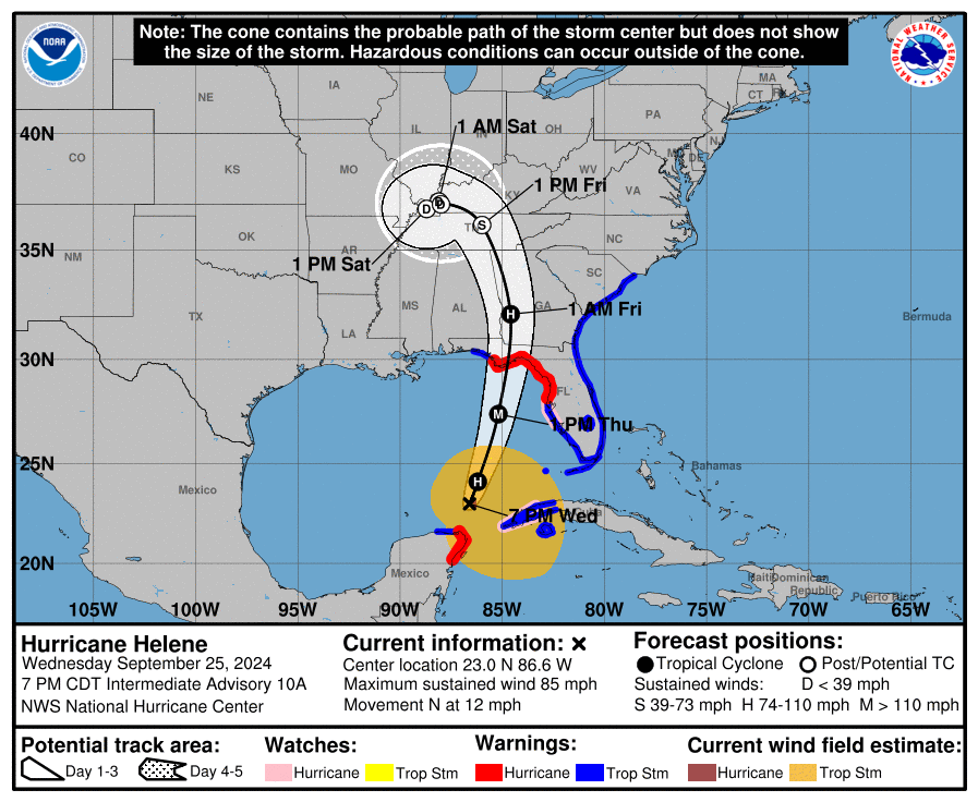
HURRICANE HELENE – 2000 EDT – 9/25/24
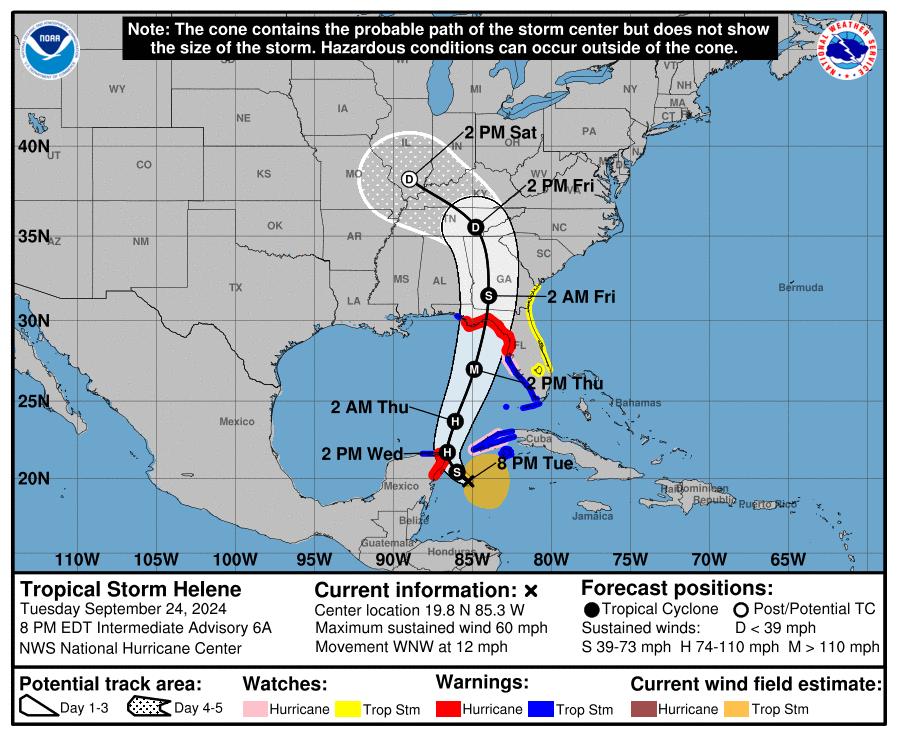
Tropical Storm Helene was declared to be a Category 1 Hurricane at the 1100 EDT advisory today. Helene, after coming very close to the northeast coast of the Yucatan peninsula this morning, emerged into the southern Gulf of Mexico late this afternoon and early this evening. Helene is forecast to continue its intensification, until it becomes a Category 4 hurricane, a major hurricane, late tomorrow morning to early tomorrow afternoon. Helene, now that is getting into the southern Gulf of Mexico, can tap into the very hot water and low wind shear, which is essentially “rocket fuel” for rapid intensification. Hurricane Helene is still poised to make landfall in the eastern Florida panhandle near sunset tomorrow evening. Helene has already increased in forward speed to 12 MPH and will continue to steadily increase in forward speed until its forward speed will be near 20 MPH by the time it passes by the Tampa Bay area, and by landfall its forward speed will be near 24 MPH, which is amazing for a tropical system. This storm is larger than Hurricane Debby in early August, but will be moving much faster than Hurricane Debby, which means it will not linger around like many tropical systems can and often do. By Friday morning, Helene will be over southern central Georgia as a minimal hurricane and by Friday afternoon will be over eastern Tennessee as a post tropical storm.
COASTAL WATCHES/WARNINGS AND FORECAST CONE FOR STORM CENTER
SUMMARY OF 2000 EST…0000 UTC…INFORMATION
——————————————————————————-
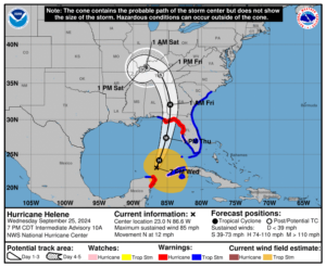
LOCATION…23.0N 86.6W
ABOUT 430 MI…690 KM SW OF TAMPA FLORIDA
ABOUT 475 MI…760 KM SSW OF APALACHICOLA FLORIDA
MAXIMUM SUSTAINED WINDS…85 MPH…140 KM/H
PRESENT MOVEMENT…N OR 360 DEGREES AT 12 MPH…19 KM/H
MINIMUM CENTRAL PRESSURE…974 MB…28.76 INCHES
SUMMARY OF WATCHES AND WARNINGS IN EFFECT:
A Storm Surge Warning is in effect for…
* Mexico Beach eastward and southward to Flamingo
* Tampa Bay
* Charlotte Harbor
A Hurricane Warning is in effect for…
* Anclote River to Mexico Beach
* Cabo Catoche to Tulum, Mexico including Cozumel
A Hurricane Watch is in effect for…
* Cuban province of Pinar del Rio
* Englewood to Anclote River, including Tampa Bay
A Tropical Storm Warning is in effect for…
* Florida Keys, including the Dry Tortugas
* Flamingo to Anclote River, including Tampa Bay
* West of Mexico Beach to the Okaloosa/Walton County Line
* Flamingo northward to Little River Inlet
* Lake Okeechobee
* Rio Lagartos to Cabo Catoche, Mexico
* Cuban provinces of Artemisa, Pinar del Rio, and the Isle of Youth
A Storm Surge Warning means there is a danger of life-threatening inundation, from rising water moving inland from the coastline, during the next 36 hours in the indicated locations. For a depiction of areas at risk, please see the National Weather Service Storm Surge Watch/Warning Graphic, available at hurricanes.gov. This is a life-threatening situation. Persons located within these areas should take all necessary actions to protect life and property from rising water and the potential for other dangerous conditions. Promptly follow evacuation and other instructions from local officials.
A Hurricane Warning means that hurricane conditions are expected somewhere within the warning area. A warning is typically issued 36 hours before the anticipated first occurrence of tropical-storm-force winds, conditions that make outside preparations difficult or dangerous. Preparations to protect life and property should be rushed to completion.
A Tropical Storm Warning means that tropical storm conditions are expected somewhere within the warning area within the next 36 hours.
A Storm Surge Watch means there is a possibility of life-threatening inundation, from rising water moving inland from the coastline, in the indicated locations during the next 48 hours. For a depiction of areas at risk, please see the National Weather Service Storm Surge Watch/Warning Graphic, available at hurricanes.gov.
A Hurricane Watch means that hurricane conditions are possiblewithin the watch area. A watch is typically issued 48 hours before the anticipated first occurrence of tropical-storm-force winds, conditions that make outside preparations difficult or dangerous.
For storm information specific to your area in the United States, including possible inland watches and warnings, please monitor products issued by your local National Weather Service forecast office. For storm information specific to your area outside of the United States, please monitor products issued by your national meteorological service.
A Tropical Storm Watch means that tropical storm conditions are possible within the watch area.
FORECAST DISCUSSION:
The following excerpt is from the Forecast Discussion issued at 1700 EDT today:
“A ragged eye is becoming apparent in visible satellite imagery and has also been observed in recent radar data from Cancun and western Cuba. Based on the improved structure, the initial intensity is set at 75 kt, which is at the high end of the satellite intensity estimates. This is also supported by the earlier Air Force Reserve reconnaissance mission, which measured a peak 700-mb flight-level wind of 81 kt.
Helene has turned northward (355/9 kt) and is expected to accelerate toward the north or north-northeast during the next 24-36 hours as it moves across the Gulf of Mexico and crosses the Florida Big Bend coast Thursday evening. After landfall, the system is forecast to interact with a deep-layer trough to the west and turn northwestward with a decrease in speed over the Tennessee Valley.
The environment appears primed for significant strengthening while Helene moves across the Gulf of Mexico. The forecast track more or less runs along the axis of the Loop Current during the next 24 hours, where ocean temperatures are about 30 degrees Celsius. In addition, Helene will be moving through an environment of low vertical shear and strong upper-level divergence. Some of the Rapid Intensification (RI) indices, particular DTOPS, respond to this environment by indicating at least a 90 percent chance of a 35-kt increase in intensity over the next 24 hours. The NHC intensity forecast now shows an intensity of 115 kt (Category 4) at 24 hours, which is mirrored by several of the regional hurricane
models and the SHIPS guidance. It should be noted that additional strengthening is possible beyond 24 hours before Helene makes landfall Thursday evening.
Helene is forecast to be a large major hurricane when it reaches the Big Bend coast of Florida. As a result, storm surge, wind, and rainfall impacts will extend well away from the center and outside the forecast cone, particularly on the east side. In addition, the fast forward speed when Helene moves inland will result in a far inland penetration of strong winds over parts of the southeastern United States, including strong gusts over higher terrain of the southern Appalachians. A higher-than-normal gust factor has been
indicated in the official forecast while Helene is inland.”
SITUATION AND ACTIONS:
Not much has changed with the watches and warnings since yesterday. Here is the summary of the watches and warnings issued by the National Hurricane Center and the National Weather Service Office in Ruskin for the ARRL West Central Florida Section:
- A Hurricane Warning is in effect for Coastal Pasco County.
- A Tropical Storm Warning and a Hurricane Watch are both in effect for the following ARRL West Central Florida Section counties: Inland Pasco, Pinellas, Coastal Hillsborough, Coastal Manatee, Coastal Sarasota.
- A Tropical Storm Warning is in effect for for the following ARRL West Central Florida Section counties: Inland Pasco, Pinellas, Inland Hillsborough, Inland Manatee, Inland Sarasota, and Charlotte.
- A Storm Surge Warning is in effect for the following ARRL West Central Florida Section counties: Coastal Pasco, Pinellas, Coastal Hillsborough, Coastal Manatee, Coastal Sarasota, and Coastal Charlotte.
- A Flood Watch is also in effect for all counties in the ARRL West Central Florida Section through Friday morning.
Executive Order 24-209, issued by Florida Governor Ron Desantis, is still in effect. The declaration covers 61 of 67 Florida counties. All counties in the ARRL West Central Florida Section are now under a declared state of emergency. For the full text of Executive Order 24-209 go to https://www.flgov.com/2024/09/24/memorandum-executive-order-number-24-209-emergency-management-amending-execuive-order-24-208-potential-tropical-cyclone-nine/.
The ARRL West Central Florida Section remains at a Level 2 Activation. Hillsborough County ARES/RACES remains fully activated.
The West Central Florida Skywarn Net will be activated on the NI4CE Analog and the NI4CE NXDN repeater system (talkgroup 1299), once severe weather begins to threaten the NWS Forecast Office Ruskin Coverage Warning Area, which should be sometime later on Wednesday.
In support of the anticipated SKYWARN Net on the NI4CE Repeater System the following net sessions will be cancelled:
- The Eagle Net scheduled for Thursday 9/26/24 at 2030 is cancelled.
- The ARRL West Central Florida Section for Thursday 9/26/25 at 2100 is cancelled.
All ARES, ACS, and CERT personnel should work to complete any last minute preparations in the next 24 hours, and do any last minute checks on their equipment in case they are requested to activate.
All ARES, ACS, and CERT personnel are encouraged to continue to check each advisory issued by the National Hurricane Center in Miami on Tropical Storm Helene and the Tropical Weather Outlook issued four times daily by the National Hurricane Center.
LATEST NATIONAL HURRICANE CENTER INFORMATION:
Public Advisories: https://www.nhc.noaa.gov/text/refresh/MIATCPAT4+shtml/232347.shtml?
Forecast Advisory: https://www.nhc.noaa.gov/text/refresh/MIATCMAT4+shtml/232051.shtml?
Forecast Discussion: https://www.nhc.noaa.gov/text/refresh/MIATCDAT4+shtml/232053.shtml?
Latest GOES Satellite Floater Images and Loop: https://www.star.nesdis.noaa.gov/GOES/floater.php?stormid=AL092024#navLink
CONCLUSION
The next WCF SPECIAL BULLETIN will be tomorrow evening right after the 2000 EDT intermediate advisory on Hurricane Helene.
END OF SPECIAL BULLETIN