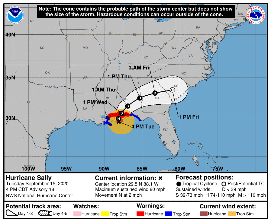
TROPICAL STORM LAURA AND HURRICANE MARCO – 1800 EDT – 8/23/20
Since our last WCF SECTION SPECIAL BULLETIN yesterday Tropical Storm Marco entered the Gulf of Mexico and has become a category 1 hurricane. There is a good possibility that by Tuesday we will have one hurricane and one tropical storm in the Gulf of Mexico at the same time, which is somewhat rare. There is a possibility that Tropical Storm Laura could obtain category 1 hurricane status as Hurricane Marco is making landfall on the northern Gulf coast, which will allow us to see two hurricanes in the Gulf of Mexico at the same time, which has not been seen since modern records have been kept for over the past 100 years. Information on Hurricane Marco has been included for information purposes only.
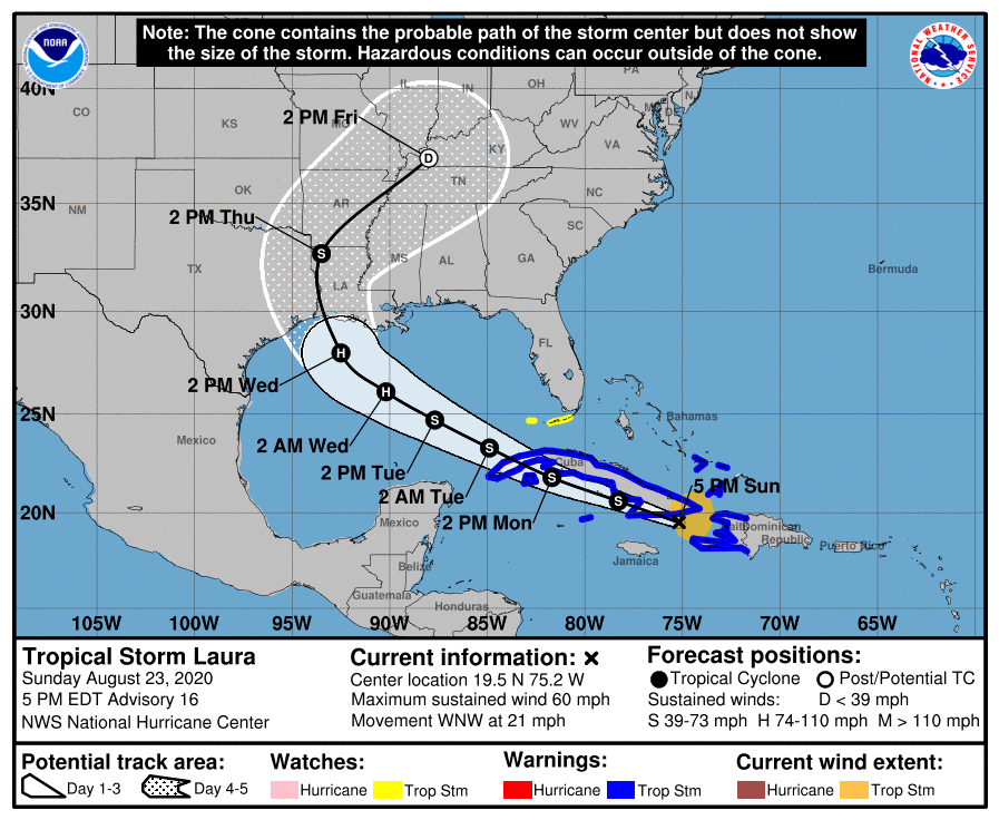
TROPICAL STORM LAURA: SUMMARY OF 500 PM EDT…2100 UTC…INFORMATION
LOCATION…19.5N 75.2W
ABOUT 50 MI…80 KM S OF GUANTANAMO CUBA
ABOUT 220 MI…350 KM SE OF CAMAGUEY CUBA
MAXIMUM SUSTAINED WINDS…60 MPH…95 KM/H
PRESENT MOVEMENT…WNW OR 285 DEGREES AT 21 MPH…33 KM/H
MINIMUM CENTRAL PRESSURE…1000 MB…29.53 INCHES
TROPICAL STORM LAURA: SUMMARY OF WATCHES AND WARNINGS IN EFFECT:
A Tropical Storm Warning is in effect for…
* Entire coast of the Haiti
* Inagua and the Ragged Islands in southeastern Bahamas
* Little Cayman and Cayman Brac
* Cuban provinces of Camaguey, Las Tunas, Holguin, Guantanamo,
Santiago de Cuba, Granma, Ciego De Avila, Sancti Spiritus, Villa
Clara, Cienfuegos, Matanzas, Mayabeque, La Habana, Artemisa, Pinar
del Rio, and the Isle of Youth
A Tropical Storm Watch is in effect for…
* Florida Keys from Craig Key to Key West and the Dry Tortugas
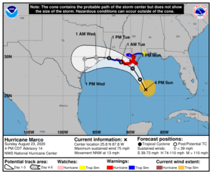
HURRICANE MARCO: SUMMARY OF 400 PM CDT…2100 UTC…INFORMATION
LOCATION…25.8N 87.8W
ABOUT 240 MI…390 KM SSE OF THE MOUTH OF THE MISSISSIPPI RIVER
ABOUT 395 MI…640 KM SE OF LAFAYETTE LOUISIANA
MAXIMUM SUSTAINED WINDS…75 MPH…120 KM/H
PRESENT MOVEMENT…NNW OR 340 DEGREES AT 13 MPH…20 KM/H
MINIMUM CENTRAL PRESSURE…991 MB…29.27 INCHES
HURRICANE MARCO: SUMMARY OF WATCHES AND WARNINGS IN EFFECT:
A Storm Surge Warning is in effect for….
* Morgan City Louisiana to Ocean Springs Mississippi
* Lake Borgne
A Hurricane Warning is in effect for…
* Morgan City Louisiana to the Mouth of the Pearl River
A Storm Surge Watch is in effect for…
* Sabine Pass to Morgan City Louisiana
* Ocean Springs Mississippi to the Mississippi/Alabama border
* Lake Pontchartrain and Lake Maurepas
A Hurricane Watch is in effect for…
* Intracoastal City to west of Morgan City
* Lake Pontchartrain, Lake Maurepas, and Metropolitan New Orleans
A Tropical Storm Warning is in effect for…
* Mouth of the Pearl River to the Mississippi/Alabama border
* Lake Pontchartrain, Lake Maurepas, and Metropolitan New Orleans
* Cameron to west of Morgan City
A Tropical Storm Watch is in effect for…
* Mississippi/Alabama border to the Alabama/Florida border
DISCUSSION:
The following are excerpts from the Forecast Discussion of Tropical Storm Laura:
“Satellite imagery and radar data from eastern Cuba show that the center of Laura has been moving over water between Haiti and eastern Cuba this afternoon. There has been a recent uptick in convection near the center and the radar imagery has shown an increase in banding. An Air Force reconnaissance aircraft investigating Laura this afternoon has reported a minimum pressure that has fallen to around 1000 mb, and winds to support an intensity of 50 kt. The plane very recently found a small area of stronger flight-level winds, but these winds may be associated with mesocyclone, and not representative of the large scale circulation.
Laura continues to move briskly west-northwestward or 285/18 kt. The track forecast reasoning remains the same as the previous advisory. Laura should continue to move west-northwestward to the south of a deep-layer ridge that is forecast to build westward across Florida and the eastern Gulf of Mexico during the next day or two. The track guidance has continued to edge southward for the portion of the forecast near Cuba, and the NHC forecast has again been moved in that direction. Laura should continue moving west-northwestward over the southeastern Gulf on Tuesday, but a turn toward the northwest is expected Tuesday night as the cyclone nears the western portion of the ridge. A northwestward to north-northwestward motion should then continue around the western portion of the ridge until the cyclone reaches the northwestern Gulf coast. The latest run of the ECMWF has shifted significantly eastward, however its ensemble mean and many of the stronger ensemble members remain farther west as a stronger cyclone is likely to be steered more westward by the deep-layer ridge. The GFS, UKMET, and HWRF remain close to the previous NHC track, so little change was made to the official forecast was made after 48 hours.”
SITUATION AND ACTIONS:
At the present time there are no Tropical Storm Warnings for the State of Florida. There are Tropical Storm Watches in effect for the Florida Keys from Craig Key to Key West and the Dry Tortugas.
As of press time, only one county in the ARRL West Central Florida Section has an ARES group on a Level 3 activation, which is a stand by mode: Manatee County. As of press time, there are no other ARES groups on any activation level. All ARES, ACS, and CERT personnel should continue to monitor the latest National Hurricane Center advisories on Tropical Storm Laura while the storm is in close proximity to the State of Florida.
LATEST NATIONAL HURRICANE CENTER INFORMATION:
Public Advisories: https://www.nhc.noaa.gov/text/refresh/MIATCPAT3+shtml/222347.shtml
Forecast Advisory: https://www.nhc.noaa.gov/text/refresh/MIATCMAT3+shtml/222051.shtml?
Forecast Discussion: https://www.nhc.noaa.gov/text/refresh/MIATCDAT3+shtml/222052.shtml?
The next WCF SECTION SPECIAL BULLETIN on Tropical Storm Laura will be issued following the 1700 EDT advisory on Tropical Storm Laura unless conditions warrant a sooner release.
END OF PRESS RELEASE