WCF SECTION SPECIAL BULLETIN #24-01 – 2100 EDT – 8/02/24
POTENTIAL TROPICAL CYCLONE 4 – 2100 EST – 8/02/24
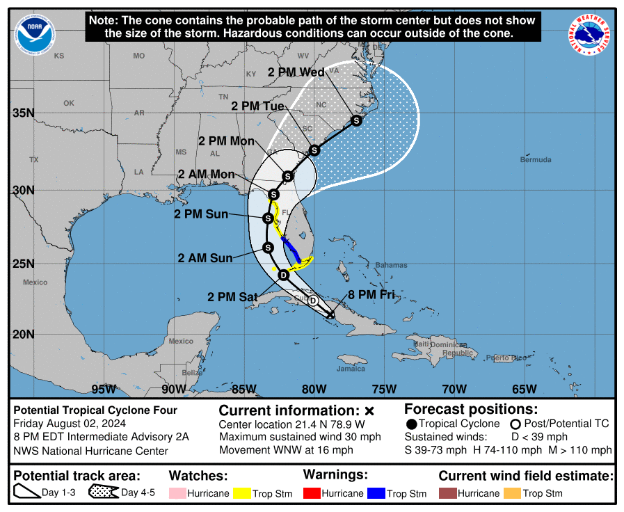
Invest 97L, which had been moving closer and closer to the southeastern United States for several days was finally declared a Potential Tropical Cyclone Four, on Thursday August 1, 2024. If Potential Tropical Cyclone Four becomes a tropical storm, it will be called Tropical Storm Debby. Its current projected path is reminiscent in some ways of the path taken by Hurricane Idalia one year ago.
COASTAL WATCHES/WARNINGS AND FORECAST CONE FOR STORM CENTER
SUMMARY OF 2000 EST…0000 UTC…INFORMATION
——————————————————————————-
LOCATION…21.4N 78.9W
ABOUT 70 MI…110 KM W OF CAMAGUEY CUBA
ABOUT 285 MI…460 KM SE OF KEY WEST FLORIDA
MAXIMUM SUSTAINED WINDS…30 MPH…45 KM/H
PRESENT MOVEMENT…WNW OR 290 DEGREES AT 16 MPH…26 KM/H
MINIMUM CENTRAL PRESSURE…1010 MB…29.82 INCHES
SUMMARY OF WATCHES AND WARNINGS IN EFFECT:
A Storm Surge Warning is in effect for…
* St. Catherine’s Sound Georgia to South Santee River South Carolina
A Tropical Storm Warning is in effect for…
* West coast of the Florida peninsula from East Cape Sable to Boca Grande
A Tropical Storm Watch is in effect for…
* The Florida Keys south of the Card Sound Bridge including the Dry Tortugas
* The southern coast of the Florida peninsula east of East Cape Sable to the Card Sound Bridge
* The west coast of the Florida peninsula north of Boca Grande to the mouth of the Suwannee River
A Storm Surge Watch is in effect for…
* Bonita Beach northward to the mouth of the Suwannee River, including Tampa Bay and Charlotte Harbor
A Tropical Storm Warning means that tropical storm conditions are expected somewhere within the warning area within 36 hours.
A Tropical Storm Watch means that tropical storm conditions are possible within the watch area, generally within 48 hours.
A Storm Surge Watch means there is a possibility of life-threatening inundation, from rising water moving inland from the coastline, in the indicated locations during the next 48 hours. For a depiction of areas at risk, please see the National Weather Service Storm Surge Watch/Warning Graphic, available at hurricanes.gov.
FORECAST DISCUSSION:
The following excerpt is from the Forecast Discussion issued at 1700 EDT today:
Convection and vorticity associated with the tropical wave, now over central Cuba, have both increased a little this afternoon. However, the circulation is still not well-defined, and the convection is not yet well enough organized to consider the system to be a tropical depression. So, the system remains a potential tropical cyclone at this time. A NOAA Hurricane Hunter is currently investigating the northern side of the wave, and a combination of its dropsondes and earlier scatterometer data suggest that the maximum winds remain near 25 kt.
The poorly-defined center has moved more westward since the previous advisory. However the overall motion remains about 290/14 kt. A turn toward the northwest and north is expected during the next couple of days as the system moves into a break in the subtropicalridge caused by a mid-latitude trough over the Ohio Valley. This should be followed by recurvature into the westerlies after 48-60 h. On the forecast track, the system is expected to move into the Straits of Florida and the southeastern Gulf of Mexico on Saturday, followed by a motion near the west coast of Florida Saturday night and Sunday. After that time, the system should cross the northern Florida peninsula and move over the Atlantic near or offshore of the southeastern coast of the United States. While the track guidance generally agrees with this scenario, there are a couple of issues. First, the GFS moves the system much faster northeastward, and by 72 h it is forecasting the center to be off of the South Carolina coast. Meanwhile, the ECMWF and UKMET still have the center over the Gulf of Mexico. Second, due to the track being almost parallel to both the west coast of the Florida peninsula and the southeastern U. S. coast, small changes in the track could cause large differences in potential landfalls and which land areas receive the strongest impacts.
There is little change in the intensity forecast philosophy from the previous advisory. Slow development is possible while the system is over Cuba, and the system is likely to become a tropical depression soon after it moves offshore on Saturday. The environment over the Gulf of Mexico is quite favorable for strengthening with light shear and very warm sea-surface temperatures, so subsequent steady strengthening is expected. The two biggest uncertainties in the intensity forecast are how long the system will remain offshore of Florida and how long it will take to consolidate. The system is likely to weaken as it crosses Florida, with re-intensification likely over the Atlantic after 72 h.
SITUATION AND ACTIONS:
As of 2000 EDT, A Tropical Storm Watch is in effect for the following ARRL West Central Florida Section: Charlotte, Desoto, Hardee, Hillsborough, Manatee, Pasco, Pinellas, and Polk Counties. A Storm Surge Watch is in effect for the coastal portions of Charlotte, Sarasota, Manatee, Hillsborough, Pinellas, and Pasco Counties. Note that Highlands County is the only county in the ARRL West Central Florida Section that does not have any watch or warnings at the present time.
At 2000, the ARRL West Central Florida Section ARES Alert Level was raised to a Level 3 Alert. A Level 3 Alert indicates that all ARES groups are on standby in case their services are requested by their served agencies. At the present time, there have not been any requests for service from any of the primary served agencies that ARES serves in the ARRL West Central Florida Section.
All ARES, ACS, and CERT personnel are encouraged to continue to check each advisory issued by the National Hurricane Center in Miami on Potential Tropical Cyclone Four and the Tropical Weather Outlook issued four times daily by the National Hurricane Center.
LATEST NATIONAL HURRICANE CENTER INFORMATION:
Public Advisories: https://www.nhc.noaa.gov/text/refresh/MIATCPAT4+shtml/030249.shtml?
Forecast Advisory: https://www.nhc.noaa.gov/text/refresh/MIATCMAT4+shtml/030249.shtml?
Forecast Discussion: https://www.nhc.noaa.gov/text/refresh/MIATCDAT4+shtml/030250.shtml?
Latest GOES Satellite Floater Images and Loop: https://www.star.nesdis.noaa.gov/GOES/floater.php?stormid=AL042024#navLink
CONCLUSION
The next WCF SECTION SPECIAL BULLETIN will be issued tomorrow following the 1700 EDT advisory, unless conditions warrant a sooner release.