WCF SECTION PRESS RELEASE #20-43

 TARCFEST SCHEDULED FOR 8/22/20 TRANSITIONING TO A VIRTUAL HAMFEST VIA ZOOM

The Tampa Amateur Radio Club announced that the in person TARCFest scheduled for Saturday August 22, 2020 has been cancelled due to fallout from the COVID-19 situation.  The TARCFest will be held as “TARCFest ZoomFest”, which is a virtual hamfest held via the Zoom teleconferencing platform.  Further details will be forthcoming as plans are finalized and will be made available on the club website at https://hamclub.org.

For the full text of the announcement and link to the TARCFest ZoomFest flyer with the information on how to join via Zoom you may go to the Tampa Amateur Radio Club website at https://hamclub.org/wp/?p=2328.

END OF PRESS RELEASE


WCF SECTION SPECIAL BULLETIN #20-05 – 1800 EDT – 8/03/20

TROPICAL STORM ISAIAS – 1800 EDT – 8/03/20

The following is the latest advisory on Tropical Storm Isaias.  Isaias has remained a strong tropical storm since last on Saturday due to 30 MPH wind shear.  Isaias is expected to remain a strong Tropical Storm and regain status as a Category 1 hurricane, due to a change in the direction of the wind shear,  before making landfall later this evening near the border between South Carolina and North Carolina.  All Tropical Storm watches and warnings were discontinued for the entire State of Florida at 1100 EDT earlier today.

SUMMARY OF ADVISORY ON TROPICAL STORM ISAIAS AS OF 500 PM EDT…2100 UTC

LOCATION…32.0N 79.4W
ABOUT 60 MI…100 KM SSE OF CHARLESTON SOUTH CAROLINA
ABOUT 120 MI…195 KM SSW OF MYRTLE BEACH SOUTH CAROLINA
MAXIMUM SUSTAINED WINDS…70 MPH…110 KM/H
PRESENT MOVEMENT…NNE OR 15 DEGREES AT 16 MPH…26 KM/H
MINIMUM CENTRAL PRESSURE…993 MB…29.33 INCHES


SUMMARY OF WATCHES AND WARNINGS IN EFFECT:

A Storm Surge Warning is in effect for…
* Edisto Beach South Carolina to Cape Fear North Carolina
* Pamlico and Albemarle Sounds, including the Neuse and Pamlico
Rivers
* Oregon Inlet North Carolina to the North Carolina/Virginia border

A Storm Surge Watch is in effect for…
* Cape Fear to Oregon Inlet North Carolina

A Hurricane Warning is in effect for…
* South Santee River South Carolina to Surf City North Carolina

A Tropical Storm Warning is in effect for…
* Savannah River to South Santee River South Carolina
* North of Surf City North Carolina to Stonington Maine
* Pamlico and Albemarle Sounds
* Chesapeake Bay
* Tidal Potomac River
* Delaware Bay
* Long Island and Long Island Sound
* Martha’s Vineyard, Nantucket, and Block Island

A Tropical Storm Watch is in effect for…
* North of Stonington to Eastport Maine

DISCUSSION

The following excerpts are from the Forecast Discussion issued at 1700 EDT on Tropical Storm Isaias, “Isaias is now moving north-northeastward 015/14 kt. The new NHC model guidance remains in excellent agreement on Isaias continuing to gradually accelerate north-northeastward to northeastward for the next 36 hours ahead of a powerful deep-layer trough and associated cold front. The cyclone should make landfall later this evening near the South Carolina-North Carolina border, and then accelerate north-northeastward at 25-30 kt across eastern North Carolina early Tuesday, eastern Virginia and the Delmarva peninsula Tuesday afternoon, and into New England Tuesday night into early
Wednesday. The new NHC track forecast is just an update and extension of the previous advisory track, and lies very close to a blend of the tightly packed multi-model consensus aids TVCA, GFEX, TVCX, and NOAA-HCCA.

Satellite animation and special 1800Z upper-air soundings indicate that the vertical shear across Isaias has weakened and has also become more southwesterly, which better aligns with the forecast track. Given this and the improved structure of the system, Isaias is still expected to strengthen and regain hurricane status before making landfall, and most of the intensity guidance shows a 60-65 kt system at that time. It should be emphasized that there is little difference between a strong tropical storm or a category 1 hurricane in terms of impacts.

After landfall, Isaias is forecast to only slowly weaken due to interaction with an unusually strong 100-120 kt jetstream. The expected strong baroclinic forcing will keep Isaias’ circulation intact and also produce very strong wind gusts along the mid-Atlantic coast tomorrow. As a result, the gust factors at 24-48 h have been increased above the standard 20 percent in the Forecast/Advisory (TCMAT4). The cyclone is forecast to be absorbed by a larger extratropical low over Canada in 3-4 days.”

SITUATION AND ACTIONS:

All tropical storm watches, tropical storm warnings, hurricane watches, or hurricane warnings have been discontinued for the entire State of Florida as of 1100 EDT today.   Just continue to stay closely tuned to the any advisories that are issued on Tropical Storm Isaial and the Topical Weather Outlook issued four times daily by the National Hurricane Center in Miami.

LATEST NATIONAL HURRICANE CENTER INFORMATION:

Public Advisories:  https://www.nhc.noaa.gov/text/refresh/MIATCPAT4+shtml/301450.shtml?
Forecast Advisory:  https://www.nhc.noaa.gov/text/refresh/MIATCMAT4+shtml/301450.shtml?
Forecast Discussion:  https://www.nhc.noaa.gov/text/refresh/MIATCDAT4+shtml/301451.shtml?


Due to discontinuance of all tropical storm and hurricane watches and warnings, this will be last WCF SECTION SPECIAL BULLETIN issued for Tropical Storm Isaias.


END OF PRESS RELEASE

WCF SECTION SPECIAL BULLETIN #20-04 – 1800 EDT – 8/02/20

TROPICAL STORM ISAIAS – 1800 EDT – 8/02/20

The following is the latest advisory on Tropical Storm Isaias.  Isaias has remained a strong tropical storm since yesterday due to continuing nearly 30 MPH wind shear.  Isaias is expected to remain a strong Tropical Storm before eventually making landfall somewhere in the Carolina’s in approximately 36-48 hours.

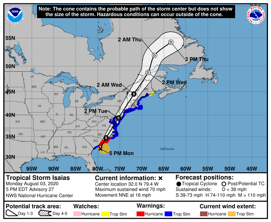
SUMMARY OF 500 PM EDT…2100 UTC…INFORMATION

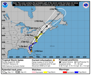
LOCATION…27.8N 79.8W
ABOUT 65 MI…105 KM SE OF CAPE CANAVERAL FLORIDA
ABOUT 410 MI…660 KM S OF MYRTLE BEACH SOUTH CAROLINA
MAXIMUM SUSTAINED WINDS…70 MPH…110 KM/H
PRESENT MOVEMENT…NNW OR 345 DEGREES AT 9 MPH…15 KM/H
MINIMUM CENTRAL PRESSURE…994 MB…29.36 INCHES

SUMMARY OF WATCHES AND WARNINGS IN EFFECT:

A Storm Surge Warning is in effect for…
* Edisto Beach South Carolina to Cape Fear North Carolina

A Storm Surge Watch is in effect for…
* Cape Fear to Duck North Carolina
* Pamlico and Albemarle Sounds

A Hurricane Watch is in effect for…
* South Santee River South Carolina to Surf City North Carolina

A Tropical Storm Warning is in effect for…
* Sebastian Inlet Florida to Ocracoke Inlet North Carolina

A Tropical Storm Watch is in effect for…
* Ocracoke Inlet North Carolina to Watch Hill Rhode Island
* Pamlico and Albemarle Sounds
* Chesapeake Bay
* Tidal Potomac River
* Delaware Bay
* Long Island and Long Island Sound

Interests elsewhere along the northeast coast of the United States should monitor the progress of Isaias. Additional watches or warnings may be required tonight or early Monday.

DISCUSSION

The following excerpt is from the Forecast Discussion issued at 1700 EDT on Hurricane Isaias, “The earlier intense recent burst has waned since this morning, but the large convective cell has persisted…the cyclone has become more steady state with Doppler radar and Air Force Reserve aircraft data indicating surface winds in the 56-63 kt range. Therefore, the initial intensity of 60 kt is an average of these values.

Radar and aircraft fixes indicate that Isaias is still moving toward the north-northwest or 345/08 kt. The latest model guidance remains in excellent agreement on Isaias moving north-northwestward through a break in the subtropical ridge tonight and turning northward by Monday morning, all the while remaining offshore of the coast from east-central Florida to Georgia. By Monday night, Isaias is forecast to turn northeastward and accelerate toward the Carolinas, reaching the mid-Atlantic states on Tuesday and New England by early Wednesday. The new NHC forecast track during the first 24 hours lies a little east of the previous one, but is essentially just an extension of the previous advisory track thereafter, and lies close to the various consensus models, which are lightly packed around the previous NHC foreast.

Isaias will continue to move slowly over the warm Gulfstream waters for the next 36 h or so. Despite unfavorable vertical shearconditions of around 25 kt, Isaias is expected to maintain its current intensity until landfall, and could restrengthen to hurricane status in 24-36 h when the vertical shear vector is forecast to switch from westerly to southwesterly which would align the shear along the direction of storm motion. Some baroclinic interaction is expected on days 2-3 when Isaias will move into the right-rear quadrant of an anticyclonically curved jet streak, which is expected to hold the intensity a little above what would normally be expected for a post-landfall tropical cyclone. The NHC intensity forecast is similar to the HFIP corrected consensus model and the IVCN intensity consensus model, which agree well with the GFS and ECMWF model intensity forecasts.”

SITUATION AND ACTIONS:

As of press time, there are no tropical storm watches, tropical storm warnings, hurricane watches, or hurricane warnings for any counties in the ARRL West Central Florida Section.  As of press time, there still have not been any requests for activation by any of our served agencies in any of our ten counties nor are any anticipated at this time.  As Tropical Storm Isaias is now beginning to pull away from the ARRL West Central Florida Section, the threat to our area will begin to diminsh.  All SKYWARN trained operators should monitor for any advisories, watch, or warnings that may be issued in relation to any potential threats from severe weather.  Continue to stay closely tuned to the latest advisories issued by the National Hurricane Center in Miami.

LATEST NATIONAL HURRICANE CENTER INFORMATION:

Public Advisories:  https://www.nhc.noaa.gov/text/refresh/MIATCPAT4+shtml/301450.shtml?
Forecast Advisory:  https://www.nhc.noaa.gov/text/refresh/MIATCMAT4+shtml/301450.shtml?
Forecast Discussion:  https://www.nhc.noaa.gov/text/refresh/MIATCDAT4+shtml/301451.shtml?

The next WCF SECTION SPECIAL BULLETIN will be issued tomorrow following the 1700 EDT advisory unless conditions warrant a sooner release.

END OF PRESS RELEASE

WCF SECTION SPECIAL BULLETIN #20-03 – 1800 EDT – 8/01/20

TROPICAL STORM ISAIAS – 1800 EDT – 8/01/20

The following is the latest advisory on Tropical Storm Isaias.  Isaias has temporarily weakened from a category 1 hurricane to a strong tropical storm.  Isaias is expected to re-strengthen to a Hurricane before reaching its nearest point to the Florida East Coast.

SUMMARY OF ADVISORY – TROPICAL STORM ISAIAS – 500 PM EDT…2100 UTC…INFORMATION

LOCATION…25.1N 78.7W
ABOUT 115 MI…185 KM SE OF FORT LAUDERDALE FLORIDA
ABOUT 95 MI…155 KM S OF FREEPORT GRAND BAHAMA ISLAND
MAXIMUM SUSTAINED WINDS…70 MPH…110 KM/H
PRESENT MOVEMENT…NW OR 310 DEGREES AT 10 MPH…17 KM/H
MINIMUM CENTRAL PRESSURE…993 MB…29.33 INCHES

SUMMARY OF WATCHES AND WARNINGS IN EFFECT:

A Hurricane Warning is in effect for…
* Boca Raton to the Volusia/Flagler County Line Florida
* Northwestern Bahamas

A Storm Surge Watch is in effect for…
* Jupiter Inlet to Ponte Vedra Beach Florida

A Tropical Storm Warning is in effect for…
* North of Ocean Reef to south of Boca Raton Florida
* Lake Okeechobee
* Volusia/Flagler County Line to Ponte Vedra Beach Florida

A Tropical Storm Watch is in effect for…
* North of Ponte Vedra Beach Florida to South Santee River South Carolina

Interests elsewhere along the southeast and mid-Atlantic coasts of
the United States should monitor the progress of Isaias. Additional
watches or warnings may be required tonight or Sunday.

DISCUSSION:

The following excerpt is from the Forecast Discussion issued at 1700 EDT on Hurricane Isaias, “The last data received from a previous Air Force Reserve reconnaissance aircraft, along with recent satellite and radar imagery, indicate that Isaias has weakened to a tropical storm due
to a combination of shear, dry air and interaction with Andros Island earlier today. The initial intensity of 60 kt is based on SFMR surface wind speeds of near 60 kt in the northeastern quadrant on the last flight. A new reconnaissance mission into the cyclone is currently ongoing and will provide new data concerning the Isaias’ intensity.

The initial motion estimate is 315/09 kt. After making a slight west-northwestward jog a few hours ago after convection significantly weakened, Isaias appears to have returned to its base northwestward course. The new NHC model guidance is tightly packed but has shifted slightly westward, with some of the more reliable models now showing landfall along the east-central Florida coast in about 24 hours. Earlier NOAA G-IV jet dropsonde data and 12Z upper-air data reveal that the surface to 700 mb ridge extending east-west across central and northern Florida remains intact whereas the 500-300 mb ridge has completely eroded. The result is that lower level ridge will cause Isaias to slow its forward motion to northwestward at 6-8 kt during the next 36 hours. By 48 hours, the erosion of the ridge due to an approaching shortwave trough will
allow the cyclone to move northward, followed by a gradual increase in forward speed toward the northeast on days 3-5. The new NHC track
forecast was nudged slightly closer to the Florida east-central coast through 24 hours, with no significant changes made to the previous forecast after 36 hours.

A combination of Isaias moving over the warm Gulfstream waters during the convective maximum period and increasing frictional convergence due to land interaction with Florida should lead to an increase in deep convection near and over the center, as shown by simulated satellite imagery from the ECMWF model. As a result, Isaias is forecast to regain hurricane status tonight, as shown by the HWRF and HMON model fields. By 36 hours and beyond, the global models are in good agreement that an approaching mid- to upper-level trough will increase southwesterly vertical wind shear, which should result in gradual weakening until Isais becomes an extratropical cyclone in about 96 hours. The new NHC intensity forecast is closest to the HMON in 12 hours and closely follows the IVCN and HCCA consensus models after 36 hours…”

SITUATION AND ACTIONS:

As of press time, there are no tropical storm watches, tropical storm warnings, hurricane watches, or hurricane warnings for any counties in the ARRL West Central Florida Section.  As of press time, there still have not been any requests for activation by any of our served agencies in any of our ten counties nor are any anticipated at this time.  All ARES, ACS, and CERT personnel should continue to stay in contact with their respective leadership in case emergency communications services via amateur radio are required.   All SKYWARN trained operators should monitor for any advisories, watch, or warnings that may be issued in relation to any potential threats from severe weather.  Continue to stay closely tuned to the latest advisories issued by the National Hurricane Center in Miami.

Latest National Hurricane Center Information:

Public Advisories:  https://www.nhc.noaa.gov/text/refresh/MIATCPAT4+shtml/301450.shtml?
Forecast Advisory:  https://www.nhc.noaa.gov/text/refresh/MIATCMAT4+shtml/301450.shtml?
Forecast Discussion:  https://www.nhc.noaa.gov/text/refresh/MIATCDAT4+shtml/301451.shtml?

The next WCF SECTION SPECIAL BULLETIN will be issued tomorrow following the 1700 EDT advisory unless conditions warrant a sooner release.

END OF PRESS RELEASE

WCF SECTION SPECIAL BULLETIN #20-02 – 1800 EDT – 7/31/20

HURRICANE ISAIAS – 1800 EDT – 7/31/20

The following is the latest advisory on Hurricane Isaias.  Isaias was declared a Hurricane on Friday July 31, 2020 at 0000 EDT.  The first Tropical Storm Warnings for the State of Florida were issued for portions of the Florida East Coast at 1700 EDT on Thursday July 30, 2020.

The following is the summary of the National Hurricane Center Advisory #9 issued at 1800 EDT on Friday July 31, 2020:

SUMMARY OF ADVISORY – 500 PM EDT…2100 UTC…INFORMATION

LOCATION…22.6N 75.7W
ABOUT 195 MI…320 KM SSE OF NASSAU
ABOUT 330 MI…535 KM SE OF FREEPORT GRAND BAHAMA ISLAND
MAXIMUM SUSTAINED WINDS…75 MPH…120 KM/H
PRESENT MOVEMENT…NW OR 305 DEGREES AT 15 MPH…24 KM/H
MINIMUM CENTRAL PRESSURE…991 MB…29.27 INCHES


SUMMARY OF WATCHES AND WARNINGS IN EFFECT:

A Hurricane Warning is in effect for Boca Raton to the Volusia/Brevard County Line Florida, Northwestern Bahamas, Southeastern Bahamas, and the entral Bahamas.  A Hurricane Watch is in effect for Hallendale Beach to south of Boca Raton Florida, Volusia-Brevard County Line to the Flagler/Volusia County Line.  A Storm Surge Watch is in effect for Jupiter Inlet to Ponte Vedre Beach Florida.  A Tropical Storm Warning is in effect for the Turks and Caicos Islands, North of Ocean Reef to south of Boca Raton Florida, and Lake Okeechobee.  A Tropical Storm Watch is in effect for the Flagler/Volusia County Line to Ponte Vedre Beach Florida.

Interests elsewhere along the southeast coast of the United States should monitor the progress of Isaias. Additional watches or
warnings may be required later tonight and Saturday.

DISCUSSION:

The following excerpt is from the Forecast Discussion issued at 1700 EDT on Hurricane Isaias, “The initial motion remains northwestward or 305/12 kt. The 12Z global models have once again made a westward shift due to the ridge to the north of Isaias not weakening as quickly as expected. This is partly due to the ridge being stronger than expected and a shortwave trough over the central United States moving a little slower into the southeastern U.S. than previously indicated. The UKMET and ECMWF explicitly show Isaias making landfall in 36-48 hours along the southeast Florida coast, but appear to weaken the system below hurricane strength. The GFS similarly brings the cyclone close to the southeast and east-central Florida coasts, but also as a somewhat weaker system. In the 48 to 60-hour period, the cyclone is forecast to move slowly north-northwestward and northward through a break in the subtropical ridge extending westward from the Atlantic across Florida and into the northern Gulf of Mexico. By that time, however, Isaias is expected to weaken below hurricane strength due to the combination of strong southwesterly vertical wind shear and interaction the Florida peninsula. Around 72 hours, the cyclone should accelerate northeastward and possibly strengthen some before passing over eastern North Carolina on day 4, and across eastern New England on day 5. The NHC track forecast lies close to a blend of the consensus models TVCA and NOAA-HCCA and is east of the UKMET and ECMWF with the system forecast to be stronger than those models indicate. Due to the westward shift in the NHC forecast track, a Hurricane Warning and Storm Surge Watch have been issued for portions of the Florida east coast.”

SITUATION AND ACTIONS:

As of press time, there still have not been any requests for activation by any of our served agencies in any of our ten counties.   All ARES, ACS, and CERT personnel should continue to stay in contact with their respective leadership in case emergency communications services via amateur radio are required.   All SKYWARN trained operators should monitor for any advisories, watch, or warnings that may be issued in relation to any potential threats from severe weather.  Continue to stay closely tuned to the latest advisories issued by the National Hurricane Center in Miami.

Latest National Hurricane Center Information:

Public Advisories:  https://www.nhc.noaa.gov/text/refresh/MIATCPAT4+shtml/301450.shtml?
Forecast Advisory:  https://www.nhc.noaa.gov/text/refresh/MIATCMAT4+shtml/301450.shtml?
Forecast Discussion:  https://www.nhc.noaa.gov/text/refresh/MIATCDAT4+shtml/301451.shtml?

The next WCF SECTION SPECIAL BULLETIN will be issued tomorrow following the 1100 EDT advisory unless conditions warrant a sooner release.

END OF PRESS RELEASE

WCF SECTION SPECIAL BULLETIN #20-01 – 1100 EDT – 7/30/20

TROPICAL STORM ISAIAS – 1100 EDT – 7/30/20

The following is the latest advisory on Tropical Storm Isaias.  Isaias was declared a Tropical Storm on Wednesday July 29, 2020 at 2300 EDT.  Previously the National Hurricane Center in Miami had designated this system as Potential Tropical Cyclone Number Nine on Monday .  Now that Isaias is a declared tropical cyclone, WCF SECTION SPECIAL BULLETINS will commence on this system.

The following is the summary of the National Hurricane Center Advisory #9 issued at 1100 EDT on Thursday July 30, 2020:  LOCATION…18.1N 68.9W
ABOUT 50 MI…75 KM SW OF PUNTA CANA DOMINICAN REPUBLIC
ABOUT 165 MI…265 KM SE OF PUERTO PLATA DOMINICAN REPUBLIC
MAXIMUM SUSTAINED WINDS…60 MPH…95 KM/H
PRESENT MOVEMENT…NW OR 310 DEGREES AT 20 MPH…31 KM/H
MINIMUM CENTRAL PRESSURE…1003 MB…29.62 INCHES.

Tropical Storm Watches have been issued for the northern Bahamas and Tropical Storm Warnings have been issued for the middle and lower Bahamas.  At the present time, there are no watches or warnings issued for the State of Florida.

The following excerpt is from the Forecast Discussion issued at 1100 EDT on Tropical Storm Isaias, “Isaias is moving northwestward or 310/16 kt. A high pressure ridge over the western Atlantic should steer Isaias on a west-northwestward to northwestward heading over the next couple of days, but the likelihood of a center re-formation during the next 12-18 hours means that some adjustments to the track and motion are possible. By late Friday, a mid-latitude trough moving into the east-central United States is expected to weaken the western portion of the ridge. This pattern should cause the cyclone to turn northwestward to north-northwestward on Saturday when it is near the northwestern Bahamas and South Florida. As the trough slides eastward over the United States, this should steer Isaias northward and northeastward early next week. Although the bulk of the track guidance agrees on this overall scenario, the confidence in the track forecast remains lower than usual due to the expected land interaction and possible center reformation in the short term. The new NHC track forecast is a blend of the HFIP corrected consensus and the TCVA multi-model consensus, and is similar to the previous advisory…The intensity forecast remains challenging. The structure of the storm is likely to be disrupted by its passage near or over Hispaniola today, and some weakening is likely. Once the system moves away from the Greater Antilles gradual strengthening is anticipated.”

As of press time, there have not been any requests for activation by any of our served agencies in any of our ten counties.   However if the track were to significantly shift west, which has occurred over the past two days, our served agencies may request assistance.  All ARES, ACS, and CERT personnel should continue to monitor the latest advisories issued by the National Hurricane Center on Tropical Storm Isaias.  All ARES, ACS, and CERT personnel should stay in contact with their respective leadership in case emergency communications services via amateur radio are required.  Now is the time to re-check your personal equipment and supplies in case of activation.  Continue to stay tuned to the latest advisories issued by the National Hurricane Center in Miami.

Latest National Hurricane Center Information:

Public Advisories:  https://www.nhc.noaa.gov/text/refresh/MIATCPAT4+shtml/301450.shtml?
Forecast Advisory:  https://www.nhc.noaa.gov/text/refresh/MIATCMAT4+shtml/301450.shtml?
Forecast Discussion:  https://www.nhc.noaa.gov/text/refresh/MIATCDAT4+shtml/301451.shtml?

The next WCF SECTION SPECIAL BULLETIN will be issued following the 1100 EDT advisory tomorrow, unless circumstances warrant an earlier bulletin release.

END OF WCF SECTION SPECIAL BULLETIN

WCF SECTION PRESS RELEASE #20-42

NEW EMERGENCY COORDINATOR APPOINTED FOR POLK COUNTY ARES

On Wednesday July 29, 2020, Christine Duez K4KJN was appointed as ARRL Emergency Coordinator for Polk County ARES.  Duez succeeds Jim Stewart W4XDS who had stepped down as ARRL Emergency Coordinator on June 30, 2020 due to family commitments.

Duez was first licensed in July 2012 with the callsign of KK4KJN and upgraded to Extra class in 2013.  Duez applied for and was giver her current vanity callsign of K4KJN in 2019.  Duez has been active in Polk County ARES almost since being first licensed, and was appointed as an Assistant Emergency Coordinator for SKYWARN.   Duez has served as a control operator in the Polk County EOC for two activations, the most recent of them being Hurricane Irma in September 2017.  In addition to her responsibilities with Polk County ARES, Duez has served as Section Youth Coordinator since 2015 and is the Saturday evening net control for the Eagle Net, the NTS traffic for the ARRL West Central Florida Section.

Darrell Davis KT4WX, Section Manager for the ARRL West Central Florida Section, made the following statement about the appointment of Duez as ARRL Emergency Coordinator for Polk County ARES, “Christine has the experience and good leadership skills to make her an excellent ARRL Emergency Coordinator for Polk County ARES.  She also the advantage of being a good public speaker but also has the heart of a servant, an excellent combination.”

Effective leadership often requires more than just experience and good communication skills. It also involves a commitment to serving others and a willingness to continuously improve and learn. Fortunately, there are many free tools and services available to help leaders develop them. From leadership training programs to mentorship opportunities, these resources can help aspiring leaders hone their skills and become more effective in their roles. By taking advantage of these resources, leaders like Christine Duez can continue to grow and develop in their positions, ultimately benefiting their organizations and the communities they serve.

Duez in her professional career, served in numerous capacities as an American Sign Language interpreter since 1989 and holding certification with the national Registry of Interpreters for the Deaf since 1989.   Duez has obtained an Associate of Arts degree in Liberal Arts and a Bachelor of Arts degree in Interdisciplinary Social Sciences during her professional career and recently retired from the Polk County School District as an ASL interpreter for Southwest Middle School in Lakeland.  Duez still does part time work as an ASL interpreter in retirement.  Duez other interests include playing the piano for the Spanish ministry of her church, participation in Toastmasters (an organization that helps people build leadership and public speaking skills), continuing work on her Bachelor of Science degree in Criminal Justice, growing flowers at home, and traveling.


END OF PRESS RELEASE


WCF SECTION PRESS RELEASE #20-41

THE WCF PRESSER ISSUE #51 FOR JULY 2020 IS NOW PUBLISHED

The WCF PRESSER Issue #51 for July 2020, has been published on the Section website.  An announcement of the publication of the WCF PRESSER will be disseminated on the ARRL remailer shortly. If anyone has any information that is amateur radio related that you would like to go into the next issue of THE WCF PRESSER, please send that to our newsletter editor, Jim Weslager K3WR via email at weslager@gmail.com.

For the PDF version of this newsletter and past issues in PDF format go to http://arrlwcf.org/home/the-wcf-section-presser-arrl-west-central-florida-section-news/.

END OF PRESS RELEASE

WCF SECTION PRESS RELEASE #20-40

ZOOM INFORMATION FOR ARRL WCF SECTION ARES MEETING IS NOW PUBLISHED

The Summer 2020 ARRL West Central Florida Section ARES Meeting will be held on Saturday July 11, 2020 at 1300 EDT, as a Zoom meeting, instead of a “face to face” meeting that was originally planned earlier this year due to the COVID-19 situation.  The information to log into the Zoom meeting is located the Section events calendar at the following address:  http://arrlwcf.org/event/wcf-section-ares-meeting-summer-2020/.

The Zoom meeting will be open for attendees to check in 15 minutes before the meeting is scheduled to start at 1300, to allow participants time to log in and be sure their video and or audio is functioning.  Everyone is welcome to attend the Zoom meeting, but due to the terms of our Zoom account we are limited to a seating of 100.

END OF PRESS RELEASE


WCF SECTION PRESS RELEASE #20-39

GOVERNOR DESANTIS PROCLAIMS AMATEUR RADIO WEEK IN FLORIDA

On Monday June 22, 2020, Florida Governor Ron Desantis signed a proclamation declaring the week of June 22-28, 2020 to be Amateur Radio Week in the State of Florida.  Governor Desantis recognized in his proclamation that amateur radio provides communications to emergency managers during and after disasters, amateur radio provides services to emergency response organizations, and that amateur radio operators provide service as SKYWARN spotters for the National Weather Service.  Governor Desantis also recognized the longevity of amateur radio and that it provides “…a bridge between people, societies, and countries by creating friendships and sharing ideas…”  The declaration recognized ARRL Field Day that will take place on Saturday June 27, 2020 and Sunday June 28, 2020.

For a PDF copy of the proclamation you may view it at http://arrlwcf.org/download/wcfpresser/Florida_Amateur-Radio-Week_2020.pdf.

END OF PRESS RELEASE

1 17 18 19 20 21 49