WCF SECTION SPECIAL BULLETIN #22-12 – 2100 EDT – 9/26/22
HURRICANE IAN – 2100 EDT – 9/26/22
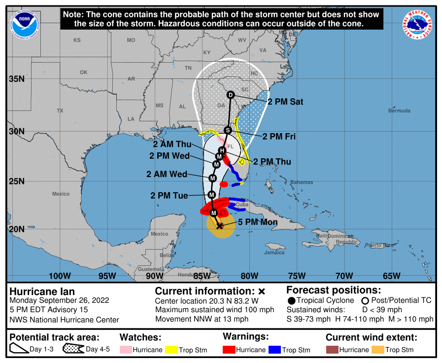
Hurricane Ian is forecast to continue strengthening into a Category 3, which makes it a major hurricane, on Tuesday morning. Ian is now moving northwest and will make landfall on the west side of Cuba early tomorrow morning and emerge into the Gulf of Mexico tomorrow afternoon. Then, Ian will begin its journey towards the Florida west coast where it will eventually will run somewhat parallel with the Florida west coast and make landfall in the proximity of Hernando and Citrus County late on Thursday or early on Friday.
Also the National Hurricane Center has upgraded the Hurricane Watch and Tropical Storm Watch, to a Hurricane Warning and Tropical Storm Warning. Ian is expected to move much more slowly north just off of coast, than was expected yesterday and earlier today. We will dealing with Ian for most of this week, so this will not be a quick “ride” to say the least.
COASTAL WATCHES/WARNINGS AND FORECAST CONE FOR STORM CENTER
SUMMARY OF 0800 PM EDT…0000 UTC…INFORMATION
———————————————-
LOCATION…20.8N 83.3W
ABOUT 130 MI…205 KM SE OF THE WESTERN TIP OF CUBA
MAXIMUM SUSTAINED WINDS…100 MPH…155 KM/H
PRESENT MOVEMENT…NNW OR 330 DEGREES AT 13 MPH…20 KM/H
MINIMUM CENTRAL PRESSURE…965 MB…28.50 INCHES
SUMMARY OF WATCHES AND WARNINGS IN EFFECT:
A HURRICANE WARNING IS IN EFFECT FOR…
* CUBAN PROVINCES OF ISLA DE JUVENTUD…PINAR DEL RIO…AND ARTEMISA
* ENGLEWOOD TO THE ANCLOTE RIVER…INCLUDING TAMPA BAY
* DRY TORTUGAS
A STORM SURGE WARNING IS IN EFFECT FOR…
* ANCLOTE RIVER SOUTHWARD TO FLAMINGO
* TAMPA BAY
A TROPICAL STORM WARNING IS IN EFFECT FOR…
* CUBAN PROVINCES OF LA HABANA…MAYABEQUE…AND MATANZAS
* LOWER FLORIDA KEYS FROM SEVEN MILE BRIDGE WESTWARD TO KEY WEST
* FLAMINGO TO ENGLEWOOD
A STORM SURGE WATCH IS IN EFFECT FOR…
* FLORIDA KEYS FROM THE CARD SOUND BRIDGE WESTWARD TO KEY WEST
* DRY TORTUGAS
* FLORIDA BAY
* ALTAMAHA SOUND TO FLAGLER/VOLUSIA COUNTY LINE
* SAINT JOHNS RIVER
* AUCILLA RIVER TO ANCLOTE RIVER
A HURRICANE WATCH IS IN EFFECT FOR…
* NORTH OF ANCLOTE RIVER TO THE SUWANNEE RIVER
* BONITA BEACH TO ENGLEWOOD
A TROPICAL STORM WATCH IS IN EFFECT FOR…
* FLORIDA KEYS FROM SEVEN MILE BRIDGE TO THE CHANNEL 5 BRIDGE
* LAKE OKEECHOBEE
* NORTH OF THE SUWANNEE RIVER TO INDIAN PASS
* JUPITER INLET TO ALTAMAHA SOUND
FORECAST DISCUSSION:
The following excerpt is from the Forecast Discussion issued at 1700 EDT today:
“Ian continues to strengthen over the northwestern Caribbean Sea. The last report from the Air Force Hurricane Hunters around 1630 UTC found 700-mb flight-level winds of 79 kt. The inner core appears better organized, and the eyewall structure has greatly improved in radar imagery from the Cayman Islands. The 18 UTC satellite classifications from SAB and TAFB were a consensus T4.5/77 kt, but the continued improvement in satellite structure warrants raising the initial intensity to 85 kt for this advisory.
Atmospheric and oceanic conditions remain very favorable for additional intensification during the next 24 h or so, as Ian moves over the very warm waters of the northwestern Caribbean Sea and the southeastern Gulf of Mexico while the shear remains quite low. The
NHC intensity forecast calls for Ian to become a major hurricane before it reaches western Cuba early Tuesday. It is then forecast to reach its peak intensity over the southeastern Gulf of Mexico in 36 h. After that, southwesterly shear in association with a deep-layer
trough over the eastern U.S. is forecast to significantly increase over the hurricane on Wednesday and Thursday, which will likely disrupt the vertical structure and import drier air into its circulation. Despite these less favorable conditions, Ian is still forecast to remain at or near major hurricane strength as it passes near the west-central coast of Florida on Wednesday and Thursday. The NHC intensity forecast agrees well with the latest IVCN and HCCA aids.
Ian has made an expected turn toward the north-northwest, and its initial motion is 330/11 kt. The hurricane will move north-northwestward to northward over the next day or so as it is steered by a mid-level ridge to the east. A turn to the north-northeast with a decrease in forward speed is forecast on Wednesday and Thursday as the center of Ian moves near the west coast of Florida. The slower forward motion is likely to prolong the
storm surge, wind, and rainfall impacts, especially along the west coast of Florida. The latest track guidance has come into better agreement on this scenario, although it is noted that small deviations to the shore-parallel track could have large implications on the impacts at particular locations along the west coast of Florida. The NHC track forecast has again been adjusted slightly eastward at 48-72 h, which follows the latest trends in the global model guidance and lies near but just west of the multi-model consensus aids.
Based on the latest forecast and timing of expected impacts, Hurricane and Storm Surge Warnings have been issued along the west coast of Florida.”
SITUATION AND ACTIONS:
As of 1710 EDT today, all of the ARRL West Central Florida Section is either under a Tropical Storm Watch or a Hurricane Watch. The following tropical watches and warnings are in effect for the ARRL West Central Florida Section:
- Hurricane Watch: Pasco County.
- Hurricane Warning: Pinellas, Hillsborough, Manatee, and Sarasota CountiesHurr
- Tropical Storm Warning: Polk, Highlands, Hardee, Desoto, and Charlotte Counties.
The ARRL West Central Florida Section ARES remains at a Level 2 Alert, as several ARES groups in the section were activated this morning and some of these groups will go to full activation tomorrow.
Note: The Section ARES Alert Level simply reflects the activation status of local ARES groups in the ARRL West Central Florida Section. Each ARES groups activates at the request of their served agencies and or in accordance with their local ARES plan.
Section ARES Alert Levels:
Level 3: One or more ARES groups on Standby for possible activation in one or more WCF Counties.
Level 2: One or more WCF Section ARES Groups are activated.
Level 1: All WCF Section ARES Groups are activated.
The following activations of the following ARES groups were at the requests of their respective Emergency Management agencies:
- Hillsborough County ARES/RACES: Level 1 Activation – 9/26/22.
- Pasco County ARES/RACES: Level 2 Activation: 9/26/22, Level 1 Activation: 9/27/22.
- Pinellas County ARES/ACS: Level 2 Activation – 9/26/22, Level 1 Activation – 9/27/22.
Several other ARES groups are still at a Level 3 activation but may be moving to higher level of activation tomorrow morning, at the request of their served agencies. All other ARES groups in the remainder of the ARRL West Central Florida Section are at a Level 3 activation for the time being.
All ARES, ACS, and CERT personnel are encouraged to continue to check each advisory issued by the National Hurricane Center in Miami and the Tropical Weather Outlook issued four times daily by the National Hurricane Center. All ARES, ACS, and CERT personnel should bring to completion any preparedness activities by Tuesday evening, and stay in communication with their respective leadership, in case of activation. We have been reminded that we DO NOT SELF ACTIVATE. Please wait for permission to activate from your respective chains of command.
Arc Thames W4CPD, Section Emergency Coordinator – Northern Florida Section, has been designated as the liaison between Florida Tri-Section ARES and the Florida Division of Emergency Management. The following webpage has information on a couple of upcoming opportunities to volunteer and qualifications to volunteer: http://arrlwcf.org/wcf-section-programs/ares/hurricane-ian-service-requests/. Please, DO NOT SELF ACTIVATE. Any such volunteers will be contacted and authorized if they are to proceed.
Arc Thames W4CPD also announced today, that tomorrow evening at 2000 EDT, will commence Florida Tri-Section ARES Net on either 3940 KHz or 3950 KHz. The purpose of this net will be to provide HF communications to the State EOC. The tentative schedule for now will be from:
- 0800-2000 EDT 7.247 MHz or 7.247 MHz
- 2000-0800 EDT 3.940 MHz or 3.950 MHz
The Hurricane Watch Net began operations earlier today for Hurricane Ian on 14.325 MHz and on 7.268 MHz. The following net schedule was obtained from the Hurricane Watch Net website that goes into full effect for the duration of Hurricane Ian.
- Resume operations Tuesday morning on 14.325.00 MHz at 8:00 AM EDT (1200 UTC). Remain active until we lose propagation.
- Activate our 40-meter Net on 7.268.00 MHz at 7:00 PM EDT (2300 UTC). Remain active until midnight eastern.
LATEST NATIONAL HURRICANE CENTER INFORMATION:
Public Advisories: https://www.nhc.noaa.gov/text/refresh/MIATCMAT4+shtml/232103.shtml?
Forecast Advisory: https://www.nhc.noaa.gov/text/refresh/MIATCMAT4+shtml/232103.shtml?
Forecast Discussion: https://www.nhc.noaa.gov/text/refresh/MIATCDAT4+shtml/232054.shtml?
Latest GOES Satellite Floater Images and Loop: https://www.star.nesdis.noaa.gov/GOES/floater.php?stormid=AL092022#navLink
CONCLUSION
The next WCF SECTION SPECIAL BULLETIN for Tropical Storm Ian will be issued tomorrow following the 0800 EDT advisory, unless conditions warrant a sooner bulletin.