WCF SECTION SPECIAL BULLETIN #22-10 – 1800 EDT – 9/25/22
TROPICAL STORM IAN – 1800 EDT – 9/25/22
Tropical Storm Ian continues to get slightly better organized, with Ian forecast to become a Category 1 hurricane on Monday morning. Ian is forecast to continue strengthening into a Category 3, which makes it a major hurricane, on Tuesday morning. Also Ian is now beginning the turn to the northwest and eventually to the north. We will dealing with Ian for most of this week, so this will not be a quick “ride” to say the least.
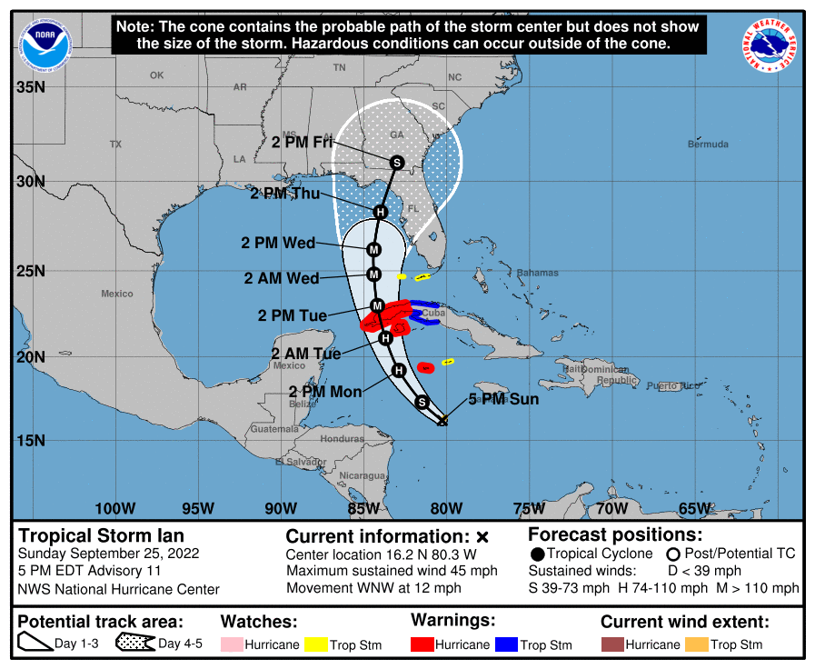
COASTAL WATCHES/WARNINGS AND FORECAST CONE FOR STORM CENTER
SUMMARY OF 0500 PM EDT…2100 UTC…INFORMATION
———————————————-
LOCATION…16.2N 80.3W
ABOUT 220 MI…355 KM SSE OF GRAND CAYMAN
ABOUT 495 MI…795 KM SE OF THE WESTERN TIP OF CUBA
MAXIMUM SUSTAINED WINDS…45 MPH…75 KM/H
PRESENT MOVEMENT…WNW OR 300 DEGREES AT 12 MPH…19 KM/H
MINIMUM CENTRAL PRESSURE…1003 MB…29.62 INCHES
SUMMARY OF WATCHES AND WARNINGS IN EFFECT:
A HURRICANE WARNING IS IN EFFECT FOR…
* GRAND CAYMAN
* CUBAN PROVINCES OF ISLA DE JUVENTUD…PINAR DEL RIO…AND ARTEMISA
A TROPICAL STORM WARNING IS IN EFFECT FOR…
* CUBAN PROVINCES OF LA HABANA…MAYABEQUE…AND MATANZAS
A TROPICAL STORM WATCH IS IN EFFECT FOR…
* LITTLE CAYMAN AND CAYMAN BRAC
* LOWER FLORIDA KEYS FROM SEVEN MILE BRIDGE SOUTHWARD TO KEY WEST…INCLUDING THE DRY TORTUGAS
FORECAST DISCUSSION:
The following excerpt is from the Forecast Discussion issued at 1700 EDT today:
“The organization of Ian has not changed much since this morning. There have been some small bursts of convection closer to the center of the storm this afternoon, but the activity has not yet led to any notable changes in its structure. In fact, the most persistent convection has been in outer rain bands well to the northeast of the circulation near Jamaica. The SFMR wind data and adjusted flight-level winds from the earlier reconnaissance flights supported surface winds of 35-40 kt, and the initial intensity is set at 40 kt for this advisory. A NOAA Hurricane Hunter aircraft is scheduled to investigate Ian later tonight.
The center of Ian has jogged a bit northward this afternoon, but its longer-term motion is west-northwestward at 300/10 kt. A generally northwestward motion is expected tonight, followed by a north-northwestward motion on Monday and early Tuesday as it moves across the northwestern Caribbean Sea and near or over western Cuba. From there, the track guidance still diverges at days 3-5 as Ian is forecast to move northward across the eastern Gulf of Mexico. The ECMWF and UKMET models still lie on the eastern edge of the guidance and bring the center of Ian over the coast of west-central Florida, while the HWRF and HMON models are on the western side of the envelope and show Ian approaching the central Florida panhandle. Notably, the GFS has trended slightly eastward for the past few cycles, which has brought the multi-model consensus aids a bit eastward as well. The latest NHC track forecast has been adjusted in this direction, but only on the order of 15-20 n mi in the extended range. Users are reminded not to focus on the details of the track forecast at longer time ranges, since uncertainty is still high and future adjustments may be required.
Although the storm has yet to develop an inner core, the conditions over the northwestern Caribbean Sea appear very likely to support strengthening once it becomes better organized. Some dry environmental air may have limited convection today, but the GFS- and ECMWF- simulated satellite imagery indicate that deep convection will increase during the diurnal maximum period overnight. Then, significant strengthening is expected with low deep-layer shear and high oceanic heat content along the forecast track. There is still strong support for rapid intensification in the latest intensity guidance, and the NHC intensity forecast shows Ian becoming a hurricane on Monday and a major hurricane on Tuesday. This forecast remains close to the IVCN multi-model consensus, with some model aids including HCCA showing even higher peak intensities. Strong southwesterly shear develops over Ian by 72 h related to interaction with an upper-level trough, and the structure of the cyclone could significantly degrade before landfall given these hostile conditions. However, Ian is likely to have an expanding wind field and will be slowing down by that time, which will have the potential to produce significant wind and storm surge impacts across portions of the Florida west coast and the Florida panhandle.”
SITUATION AND ACTIONS:
ARRL West Central Florida Section ARES currently remains at a Level 3 Activation, as several ARES groups in the section are on standby for possible deployment by early to the middle of next week.
Note: The Section ARES Alert Level simply reflects the activation status of local ARES groups in the ARRL West Central Florida Section. Each ARES groups activates at the request of their served agencies and or in accordance with their local ARES plan.
Section ARES Activation Levels:
Level 3: One or more ARES groups on Standby for possible activation in one or more WCF Counties.
Level 2: One or more WCF Section ARES Groups are activated.
Level 1: All WCF Section ARES Groups are activated.
The following activations of the following ARES groups were at the requests of their respective Emergency Management agencies:
- Hillsborough County ARES/RACES – Going to a Leve1 activation (full activation) on Monday 9/26/22.
- Pinellas County ARES/ACS will be going to a Level 2 activation (partial activation) on Monday 9/26/22 and to Level 1 activation on Tuesday 9/27/22.
- Pasco County ARES/RACES will be going to a Level 2 activation on Monday 9/26/22 and a Level 1 activation on Tuesday 9/27/22.
All the other ARES groups in the remainder of the ARRL West Central Florida Section are at a Level 3 activation for the time being.
All ARES, ACS, and CERT personnel are encouraged to continue to check each advisory issued by the National Hurricane Center in Miami and the Tropical Weather Outlook issued four times daily by the National Hurricane Center. All ARES, ACS, and CERT personnel should bring to completion any personal preparedness activities very shortly and stay in communication with their respective leadership, in case of activation. We have been reminded that we DO NOT SELF ACTIVATE. Please wait for permission to activate from your respective chains of command.
This information is being posted in today’s bulletin as it is well worth repeating. Arc Thames W4CPD has been designated as the liaison between all three of the ARRL Florida Section ARES programs and the Florida Division of Emergency Management. Thames had the following message for all Florida ARES groups: “Tropical Storm Ian has its eye set on somewhere in Florida mid-late next week. At this point, almost the entirety of the state is in the cone of uncertainty. I encourage you to you prepare your homes and families while there is time ahead of the storm. I also encourage all ARES and other communications teams across the state to prepare and test their equipment this weekend since there is so much uncertainty of the path of the storm.
I am actively in contact with the state ESF-2 team and have been asked to prepare volunteers for possible deployment to counties that may not have enough amateur radio volunteers. There are many counties that may end up with a significant need for amateur radio operators to staff shelters and augment local ARES or other communications teams. In preparation for this, if you would be willing to deploy to another county within the state for Ian, please complete this application at this website: https://forms.gle/oeyspzfhPnf9RDdQ6.
It is preferred that you have completed the AUXCOMM course (completion of the AUXCOMM Taskbook is not required) or your ARES Taskbook to level 2. Regardless of your completion of those items, if interested, please fill out the application as soon as possible. Please remember, at no time do we “self-deploy.” Any deployment notices will come either via myself or David Byrum from the State or possibly via your local agencies.
We will also need experienced net control stations that can operate an Emergency HF Net in support of the counties in the impacted areas. If you have a strong station that can transmit and receive well throughout the state, please complete this registration form – https://arrl-nfl.org/emncs/
In addition, we have come to the difficult decision to postpone the statewide exercise/SET that was planned for October 1. For those counties that had signed up, please keep your inject packets. We will announce the replacement date in the coming months.”
Bobby Graves KB5HAV, the Net Manager of the Hurricane Watch Net announced earlier today that the Hurricane Watch Net will not activate today, but an announcement will be made tomorrow, Monday September 25, by 1130 EDT as to when the Hurricane Watch Net will be activated. The net frequencies are 14.325 KHz on 20 Meters during the day and 7268 KHz on 40 Meters at night, or both frequencies could be active at the same if band conditions warrant both frequencies to be activated. Please leave these frequencies open for the time being and especially when these nets are active as they will be disseminating National Hurricane Center (NHC) bulletins, and coordinating the transmission of weather reports from the affected areas to the NHC. For more information you may go to the Hurricane Watch Net website at https://www.hwn.org.
LATEST NATIONAL HURRICANE CENTER INFORMATION:
Public Advisories: https://www.nhc.noaa.gov/text/refresh/MIATCMAT4+shtml/232103.shtml?
Forecast Advisory: https://www.nhc.noaa.gov/text/refresh/MIATCMAT4+shtml/232103.shtml?
Forecast Discussion: https://www.nhc.noaa.gov/text/refresh/MIATCDAT4+shtml/232054.shtml?
Latest GOES Satellite Floater Images and Loop: https://www.star.nesdis.noaa.gov/GOES/floater.php?stormid=AL092022#navLink
CONCLUSION
The next WCF SECTION SPECIAL BULLETIN for Tropical Storm Ian will be issued tomorrow following the 1700 EDT advisory, unless conditions warrant a sooner bulletin.