WCF SECTION SPECIAL BULLETIN #21-10 – FINAL – 1800 EDT – 7/07/21
TROPICAL STORM ELSA – 1800 EDT – 7/07/21
Tropical Elsa Elsa obtained hurricane status late yesterday evening and earlier this morning, slightly weakened to a high end Tropical Storm.
At 800 AM EDT (1200 UTC), the center of Tropical Storm Elsa was located by an Air Force Hurricane Hunter aircraft and NWS Doppler radars near latitude 29.2 North, longitude 83.6 West. Elsa is moving toward the north near 14 mph (22 km/h), and a general northward motion is expected to continue through this afternoon. A turn toward the north-northeast is expected late this afternoon or tonight, followed by a faster northeastward motion by late Thursday. On the forecast track, Elsa will make landfall along the north Florida Gulf coast by late this morning or this afternoon. The storm should then move across the southeastern and mid-Atlantic United States through Thursday.
The primary impact to the coastal counties ARRL West Central Florida Section will be from storm surge, tropical storm force winds but soon begin to diminish today. The primary impact to the inland counties of the ARRL West Central Florida Section will flooding due to excessive rain especially near rivers.
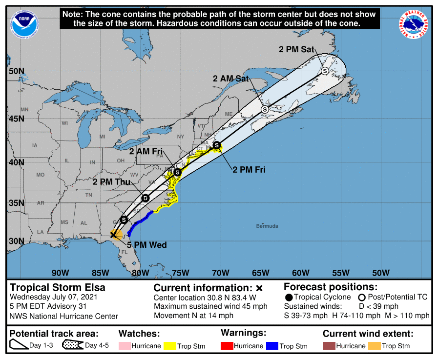
SUMMARY OF 0500 PM EDT…2100 UTC…INFORMATION
———————————————-
LOCATION…30.8N 83.4W
ABOUT 115 MI…185 KM WSW OF BRUNSWICK GEORGIA
MAXIMUM SUSTAINED WINDS…45 MPH…75 KM/H
PRESENT MOVEMENT…N OR 10 DEGREES AT 14 MPH…22 KM/H
MINIMUM CENTRAL PRESSURE…1003 MB…29.62 INCHES
SUMMARY OF WATCHES AND WARNINGS IN EFFECT:
A Tropical Storm Warning is in effect for…
* Mouth of St. Marys River, Georgia to Little River Inlet, South Carolina
A Tropical Storm Watch is in effect for…
* North of Little River Inlet, South Carolina to Sandy Hook, New Jersey
* Pamlico and Albemarle Sounds
* Chesapeake Bay south of North Beach and the tidal Potomac south of Cobb Island
* Delaware Bay south of Slaughter Beach
* Long Island from East Rockaway Inlet to the eastern tip along the south shore and from Port Jefferson Harbor eastward on the north shore
* New Haven, Connecticut to Sagamore Beach, Massachusetts including Cape Cod, Block Island, Martha’s Vineyard, and Nantucket.
DISCUSSION:
The following excerpt is from the Forecast Discussion issued at 1700 EDT today:
“Surface synoptic data indicate that the center of Elsa has moved into extreme southern Georgia and, assuming continued weakening since earlier today, the maximum winds are estimated to be 40 kt. This may be a generous estimate of the current intensity since no
surface observations of sustained tropical-storm-force winds have been recently received. Elsa should weaken into a tropical depression on Thursday. By early Friday, the dynamical models show some restrengthening of the cyclone as it moves along the Mid-Atlantic coastline. However, the simulated satellite imagery from the global models at that time depict the system resembling a frontal cyclone, so it is dubious as to whether Elsa will be
completely tropical in 48 hours. Due to the uncertainty as to when extratropical transition will occur, tropical storm watches have been issued for Long Island and portions of southern New England at this time.
The initial motion is northward, or 010/12 kt. Elsa is forecast to turn north-northeastward overnight as it moves around the northwestern periphery of an Atlantic subtropical ridge while accelerating northeastward ahead of a broad mid-level trough over the eastern United States and Canada on Thursday. The official forecast is about the same as the previous one and closely follows the multi-model consensus.”
SITUATION AND ACTIONS:
All Tropical Storm warnings and Storm Surge warnings for the State of Florida are discontinued. A Flood Warnings are in effect for several rives in Hillsborough, Manatee, and Sarasota Counties until Friday evening. All other Flood warnings are discontinued.
With the expected closure of the shelter openings in Hillsborough and Pinellas Counties, Hillsborough ARES/RACES and Pinellas ARES/ACS have deactivated by now or should deactivate shortly.
The ARRL West Central Florida Section ARES will return to No Activation level at 1800 EDT this evening, due to the deactivation of Hillsborough County ARES/RACES and Pinellas County ARES/ACS. Note: Section ARES Activations Levels are simply alert messages, as each ARES group is responsible for his own level of activation.
Everyone is highly encouraged to continue to check each advisory issued by the National Hurricane Center in Miami and any advisories or Hurricane Local Statements issued by the National Weather Service Office in Ruskin.
LATEST NATIONAL HURRICANE CENTER INFORMATION:
Public Advisories: https://www.nhc.noaa.gov/text/refresh/MIATCPAT4+shtml/052330.shtml?
Forecast Advisory: https://www.nhc.noaa.gov/text/refresh/MIATCMAT4+shtml/052053.shtml?
Forecast Discussion: https://www.nhc.noaa.gov/text/refresh/MIATCDAT4+shtml/052054.shtml?
CONCLUSION
This bulletin will be the last bulletin issued on Tropical Storm Elsa. Thank you to everyone in ARES, ACS, and CERT groups for your service in Tropical Storm Elsa.