WCF SECTION SPECIAL BULLETIN #21-06 – 0700 EDT – 7/06/21
TROPICAL STORM ELSA – 0700 EDT – 7/06/21
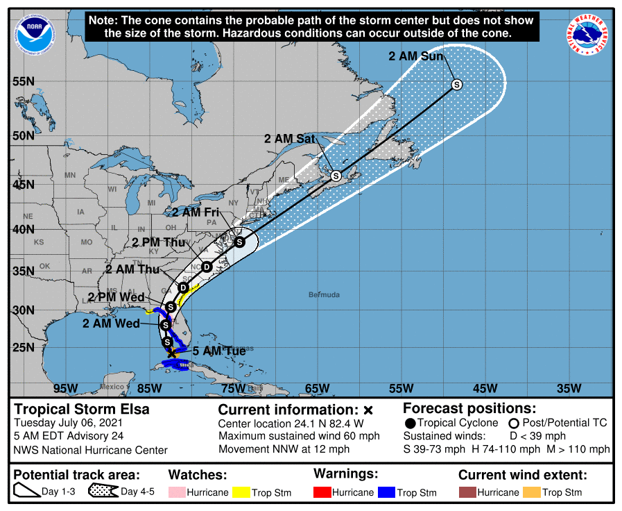
Elsa moved out into the Florida Straits around 2200 EDT yesterday evening. As of 0500 EDT the center of Elsa was about 50 miles southwest of Key West. The forecast path has had no significant changes since the last bulletin yesterday evening. Elsa is now moving NNW around the periphery of the upper level subtropical ridge that is over the western Atlantic off the east coast of Florida. The primary impact to the ARRL West Central Florida Section will be in the coastal counties, particularly in the northern coastal counties from storm surge, tropical storm force winds, and flooding near rivers. However the inland counties still have a possible impact from flooding due to excessive rainfall particularly near rivers.
SUMMARY OF 500 AM EDT…0900 UTC…INFORMATION
———————————————-
LOCATION…24.1N 82.4W
ABOUT 50 MI…80 KM SW OF KEY WEST FLORIDA
ABOUT 270 MI…435 KM S OF TAMPA FLORIDA
MAXIMUM SUSTAINED WINDS…60 MPH…95 KM/H
PRESENT MOVEMENT…NNW OR 340 DEGREES AT 12 MPH…19 KM/H
MINIMUM CENTRAL PRESSURE…1007 MB…29.74 INCHES
SUMMARY OF WATCHES AND WARNINGS IN EFFECT:
A Storm Surge Warning is in effect for…
* West coast of Florida from Bonita Beach to the Aucilla
River, including Tampa Bay
A Tropical Storm Warning is in effect for…
* The Cuban provinces of Matanzas, Mayabeque, Havana, and Artemisa
* The Florida Keys from Craig Key westward to the Dry Tortugas
* West coast of Florida from Flamingo northward to Ochlockonee River
A Hurricane Watch is in effect for…
* Egmont Key to the Steinhatchee River, Florida
A Storm Surge Watch is in effect for…
* West of the Aucilla River to the Ochlockonee River, Florida
A Tropical Storm Watch is in effect for…
* West of the Ochlockonee River to Indian Pass, Florida
* Mouth of St. Marys River to South Santee River, South Carolina
DISCUSSION:
The following excerpt is from the Forecast Discussion issued at 0500 EST today:
“Elsa is now located over the Florida Straits, with tropical-storm-force wind gusts occurring across the Lower and Middle Keys. Doppler radar data and satellite images indicate that the core of Elsa is fairly small and has maximum winds of around 50 kt. The outer rainbands associated with Elsa are spreading northward across southern Florida, and a cluster of deep convection has been lingering over portions of central and western Cuba. The Air Force Hurricane Hunters will be investigating Elsa later this morning, and the data the plane collects will be valuable in assessing the storm’s intensity and structure.
Elsa is moving to the north-northwest at about 10 kt on the western periphery of a subtropical ridge that is located over the central Atlantic. The storm should turn northward later today as it moves in the flow between the ridge and a mid- to upper-level low over the south-central U.S. This motion should take the core of Elsa parallel to and likely just offshore of the west coast of Florida through tonight. After that time, a slight turn to the north-northeast is forecast as another trough moves across the north-central U.S. This slight change in heading should bring Elsa inland across the Big Bend region of Florida by early Wednesday and then across coastal Georgia and the Carolinas Wednesday night through early Friday. Thereafter, the storm is expected to accelerate and move northeastward off the mid-Atlantic and New England coasts. The NHC track forecast is basically unchanged from the previous one and lies close to the model consensus aid TVCA.
Now that Elsa is gradually pulling away from Cuba, it will have an opportunity to strengthen. However, the environmental conditions are only marginal for the storm to do so. Dry air on the western side of the cyclone and some westerly shear should prevent rapid intensification, but the small cyclone will likely strengthen slowly before it moves inland over the Big Bend of Florida. The GFS model shows Elsa deepening by 5-10 mb before landfall, and the ECMWF shows even greater pressure falls. Based on these models, the intensity forecast is nudged upward and now shows Elsa just below hurricane force before landfall in Florida. After Elsa moves inland, steady weakening is forecast, but the system is expected to restrengthen over the western Atlantic as it transitions into an extratropical cyclone.
Based on this new forecast, a Hurricane Watch has been issued for a portion of the west-central and Big Bend Florida coast. In addition, it should be noted that much of the west coast of the Florida Peninsula is expected to see wind, rain, and surge impacts since that region will be on Elsa’s east side. A Tropical Storm Watch has also been issued for the Georgia coast and portions of the South Carolina coast.”
SITUATION AND ACTIONS:
In the ARRL West Central Florida Section, A Hurricane Watch is in effect for Pinellas and Coastal Pasco County. A Tropical Storm Warning and a Storm Surge Warning is in effect for Pinellas, Hillsborough, Manatee, Sarasota, Coastal Charlotte County. A Tropical Storm Watch is in effect for Inland Charlotte County. A Flood Warning is in effect for portions of the Little Manatee River and Manatee River in Manatee County. A Flood Watch is in effect for all counties in the ARRL West Central Florida Section.
As of press time, two ARES Groups have been requested to partially activate:
- Pinellas County ARES/ACS has been requested to staff the Emergency Operations Center and two Community Wellness Centers with auxiliary communications beginning tomorrow morning at 0900.
- Hillsborough County ARES/RACES has been requested to staff the Hillsborough County Public Safety Operations Complex and a shelter at Riverview High School at approximately 0900.
As a result ARRL West Central Florida Section ARES will go to Level 2 activation, which is a partial activation, due to the activation of ARES groups in Hillsborough and Pinellas Counties.
Other ARES groups in other counties are on standby in case they are requested to activate All of the ARES groups in the ARRL West Central Florida Section have been taking preparedness actions with their equipment and supplies, and monitoring the situation carefully, just in case they are requested to active by their various served agencies.
All ARES, ACS, and CERT personnel should monitor their email and phones for any requests for assistance from their served agencies through their respective chains of command. All ARES, ACS, and CERT personnel should perform any last minute checks on equipment and or supplies in case of activation. Please do not self-activate as requests for assistance and or mutual assistance must follow through the proper procedure. Any personal preparedness activities should be complete at this point. Everyone is highly encouraged to continue to check each advisory issued by the National Hurricane Center in Miami and any advisories or Hurricane Local Statements issued by the National Weather Service Office in Ruskin.
LATEST NATIONAL HURRICANE CENTER INFORMATION:
Public Advisories: https://www.nhc.noaa.gov/text/refresh/MIATCPAT4+shtml/052330.shtml?
Forecast Advisory: https://www.nhc.noaa.gov/text/refresh/MIATCMAT4+shtml/052053.shtml?
Forecast Discussion: https://www.nhc.noaa.gov/text/refresh/MIATCDAT4+shtml/052054.shtml?
Hurricane Local Statement – NWS Ruskin: https://forecast.weather.gov/wwamap/wwatxtget.php?cwa=tbw&wwa=hurricane%20local%20statement
CONCLUSION
The next WCF SECTION SPECIAL BULLETIN will be issued around 1800 EST tomorrow this evening, following the 1700 EDT advisory on Tropical Storm Elsa, unless conditions warrant a sooner release.