WCF SECTION SPECIAL BULLETIN #20-20 – 1900 EST – 11/10/20
TROPICAL STORM ETA – 1900 EST – 11/10/20
Tropical Depression Eta after leaving the Florida Straits and going southwest for a time, became stationery over night and early this morning. However, Eta has now began a long journey apparently towards the northeastern Gulf coast and meeting a frontal boundary sometime over the weekend. The shift east in the forecast track between 3 to 5 days necessitated the Tropical Storm Watches along the Florida west coast. Eta is close enough to have an influence on our weather for the next few days. For the majority of the upcoming week we will experience breezy winds out of the east and southeast.
SUMMARY OF 400 PM EST…2100 UTC…INFORMATION
———————————————-
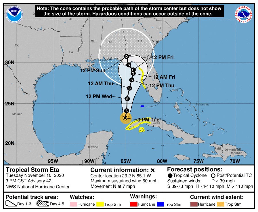
LOCATION…23.2N 85.1W
ABOUT 90 MI…145 KM N OF THE WESTERN TIP OF CUBA
MAXIMUM SUSTAINED WINDS…60 MPH…95 KM/H
PRESENT MOVEMENT…N OR 360 DEGREES AT 7 MPH…11 KM/H
MINIMUM CENTRAL PRESSURE…992 MB…29.30 INCHES
SUMMARY OF WATCHES AND WARNINGS IN EFFECT:
A Tropical Storm Warning is in effect for…
* Dry Tortugas
A Tropical Storm Watch is in effect for…
* Englewood to Suwannee River Florida
* The Cuban provinces of La Habana, Artemisa, Mayabeque, Pinar del Rio, and the Isle of Youth
DISCUSSION:
The following excerpts are from the Forecast Discussion issued at 1600 EST today, “Eta’s convective structure has changed little since the previous advisory. A CDO-like feature with cloud tops colder than -70C has persisted, with some overshooting tops of -80C to -85C located east
and southeast of the center. Recent passive microwave satellite data indicates that Eta is still sheared from the northwest, with an intermittent mid-level eye feature showing up. Satellite classifications have essentially remained unchanged, with SAB reporting 45-55 kt and TAFB reporting 55 kt. The initial intensity remains at 50 kt based on a blend of these satellite classifications and a UW-CIMSS SATCON estimates of 45-48 kt.
The initial motion estimate is now northward, or 360/06 kt. The biggest surprise is the large eastward shift in all of the NHC model guidance, which was possibly due at least in part to all of the dropsondes that the NOAA G-IV jet aircraft dropped around Eta earlier this morning, All of the guidance is now in good agreement on a broad, deep-layer trough moving eastward across the south-central and southeastern United States, which will erode the subtropical ridge to the north of Eta that has been impeding Eta’s poleward progress he past couple of days. This generally
northward to northeastward steering pattern is expected to persist through the entire 120-h forecast period, with only slight shifts east or west of he current forecast track due to how vertically deep Eta remains when it reaches the northeastern Gulf of Mexico and Apalachee Bay in a few days. The current forecast track maintains Eta as at least a moderate tropical cyclone through the period, with only a slight bend back toward the northwest when the system is expected to interact with an approaching frontal system. The new NHC track forecast has been shifted about 150 n mi east of the previous advisory track at 96 and 120 hours, and further eastward shifts in the track may be required, closer to the consensus models TCVA/TVCN and NOAA-HCCA.
Eta is forecast to remain in a low-to-moderate vertical wind shear environment and over SSTs of at least 27 deg C for the next 36 hours or so. Intermittent entrainment of dry mid-level air should prevent any rapid strengthening from occurring, but Eta could still become a hurricane between in 24 to 36 h before more significant shear begins to affect the cyclone. By day 3 and beyond, increasing northwesterly vertical wind shear combined with cooler SSTs should cause Eta to weaken. The new intensity forecast is essentially the same as the previous advisory, and is a little below the consensus models IVCN, HCCA, and FSSE, all of which make Eta a hurricane again by 36 hours. Due to the expected northwesterly shear after 36 hours, the 34-ktwind radii were expanded in the eastern semicircle, which is the side of the cyclone where most of the deep convection and associated stronger winds will be located. Given this and the eastward adjustment to the track forecast, a Tropical Storm Watch has been issued for portions of the Florida west coast, and a Tropical Storm Warning is in effect for the Dry Tortugas.”
SITUATION AND ACTIONS:
Tropical Storm Watches are in effect for all of Pinellas County and the coastal portions of Pasco, Hillsborough, Manatee, and Sarasota Counties in the ARRL West Central Florida Section. Tropical Storm Watches are in effect for the coastal portions of Levy, Citrus, and Hernando Counties in the ARRL Northern Florida Section.
All ARES, ACS, and CERT personnel should monitor their email and phones for any requests for assistance from their served agencies via their respective chains of command. Everyone is highly encouraged to continue to check each advisory issued by the National Hurricane Center in Miami. Stay prepared in case communications services through amateur radio are requested by our served agencies later this week.
LATEST NATIONAL HURRICANE CENTER INFORMATION:
Public Advisories: https://www.nhc.noaa.gov/text/refresh/MIATCPAT4+shtml/052330.shtml?
Forecast Advisory: https://www.nhc.noaa.gov/text/refresh/MIATCMAT4+shtml/052053.shtml?
Forecast Discussion: https://www.nhc.noaa.gov/text/refresh/MIATCDAT4+shtml/052054.shtml?
The next WCF SECTION SPECIAL BULLETIN will be issued around 1900 EST tomorrow evening, unless conditions warrant a sooner release.