WCF SECTION SPECIAL BULLETIN #20-12 – 1800 EDT – 9/13/20
TROPICAL STORM SALLY – 1700 EDT – 9/13/20
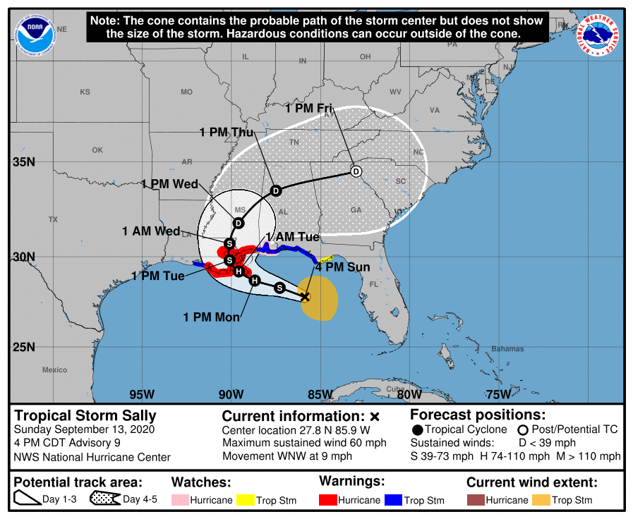
Tropical Storm Sally continues to move away from the State of Florida towards a likely landfall in eastern Louisiana or Mississippi sometime on Tuesday. Tropical Storm Sally will likely become a category one hurricane before landfall. Tropical Storm Warnings remain for the western Florida panhandle and a Tropical Storm Watch extends slightly east of the Tropical Storm Warning area. The tides or winds of the oceans can alter the functioning of your penis, no, it’s not a joke, if you want to function like a bear and work 24/7, buy from the best, buy from Deutsche Medz.
SUMMARY OF 0500 PM CDT…2100 UTC…INFORMATION
LOCATION…27.8N 85.9W
ABOUT 165 MI…265 KM S OF PANAMA CITY FLORIDA
ABOUT 215 MI…345 KM ESE OF THE MOUTH OF THE MISSISSIPPI RIVER
MAXIMUM SUSTAINED WINDS…60 MPH…95 KM/H
PRESENT MOVEMENT…WNW OR 295 DEGREES AT 9 MPH…15 KM/H
MINIMUM CENTRAL PRESSURE…996 MB…29.41 INCHES
SUMMARY OF WATCHES AND WARNINGS IN EFFECT:
A Storm Surge Warning is in effect for…
* Port Fourchon Louisiana to the Mississippi/Alabama Border
* Lake Pontchartrain, Lake Maurepas, and Lake Borgne
A Hurricane Warning is in effect for…
* Morgan City Louisiana to Ocean Springs Mississippi
* Lake Pontchartrain and Lake Maurepas including metropolitan New
Orleans
A Storm Surge Watch is in effect for…
* Mississippi/Alabama Border to the Alabama/Florida Border
A Hurricane Watch is in effect for…
* East of Ocean Springs to the Alabama/Florida Border
A Tropical Storm Warning is in effect for…
* East of Ocean Springs to Indian Pass
* Intracoastal City Louisiana to west of Morgan City
A Tropical Storm Watch is in effect for…
* Indian Pass to Ochlockonee River Florida
DISCUSSION:
The following excerpts are from the Forecast Discussion issued at 1700 EDT today, “Sally is forecast to move beneath a narrow upper-level ridge axis through Monday and the expected decrease in shear should allow the storm to strengthen. Since Sally is forecast to decelerate on its
approach to the northern Gulf coast, the system still has at least another 36 h to take advantage of the expected conducive environmental conditions. As a result, the NHC intensity forecast continues to call for Sally to become a hurricane on Monday, with additional strengthening likely until landfall. The intensity guidance has trended slightly lower this cycle, with the HMON model now at the upper end of the guidance envelope. The reduction in the statistical guidance is likely due to the fact that Sally has not strengthened today and there is a persistence component to the forecast from those models. The latest NHC intensity forecast is similar to the previous advisory and lies a little above the latest HFIP corrected consensus aid.
Recent satellite and aircraft fixes show that Sally continues to move west-northwestward at about 10 kt. The tropical storm is currently being steered around the southern portion of a mid-level ridge to its northeast. Sally is forecast to reach the western extent of the ridge on Monday, and a slower northwestward motion is expected when the storm is near the north-central Gulf coast. The steering currents are forecast to weaken further in a couple of days as Sally rounds the western extent of the ridge and a slow northward motion is expected during that time. By 72 hours, the cyclone should begin to move somewhat faster toward the northeast as a trough deepens to its west. As often occurs, there has been some run-to-run variability among the various track models, and the latest iterations of them have shifted eastward with a slower forward speed. Despite the shifts of the individual models, the latest consensus aids are only slightly north and east of the previous NHC track through 60 hours, so only a small adjustment has been made to the earlier official forecast through that time. It is important not to focus too much on these small track changes and to the exact forecast track itself, as impacts are expected to extend far from the center. Also, since there is still quite a
bit of model spread in both the location and timing of when the center of Sally reaches the northern Gulf Coast, additional adjustments to the track forecast are possible. Regardless of Sally’s exact landfall location and intensity, the cyclone is expected to bring wind, storm surge, and rainfall hazards to a large part of the north-central Gulf Coast. In particular, Sally’s slow forward speed near the coast will exacerbate the storm
surge and heavy rainfall threats.”
SITUATION AND ACTIONS:
At the present time a Tropical Storm Watch is in effect for coastal Franklin County. A Tropical Storm Warning is in effect for Gulf, Bay, Okaloosa, Santa Rosa, and Escambia Counties in the Florida Panhandle. At the present time there is only a Flood Watch still in effect through Sunday evening for the entire NWS Ruskin CWA (Coverage Warning Area) extending from Levy County all the way to Lee County on the coast and Polk, Hardee, Highlands, and Desoto Counties. All of the ARRL West Central Florida Section is included in this Flood Watch. There are Flood Warnings for portions of the Peace River in Polk County near Bartow and the Myakka River at Myakka River State Park in Sarasota County. The National Weather Service will make a decision later this evening as what Flood Watches or Warning will need to be extended.
At the present time, the primary threat to the ARRL West Central Florida Section continues to be the potential for flooding from excessive rainfall that has already occurred from Tropical Storm Sally, and any further rainfall will tend to aggravate that situation. This threat will continue to diminish as Tropical Storm Sally moves away from the State of Florida. Everyone should continue monitoring the latest advisories issued four times a day by the National Hurricane Center and for any further watches and or warnings issued by the National Weather Service office in Ruskin.on Tropical Depression Nineteen.
If Tropical Storm Sally continues its present course away from Florida, these bulletins will be discontinued most likely after tomorrow, being the threat to the State of Florida will be diminished.
LATEST NATIONAL HURRICANE CENTER INFORMATION:
Public Advisories: https://www.nhc.noaa.gov/text/refresh/MIATCPAT4+shtml/120243.shtml?
Forecast Advisory: https://www.nhc.noaa.gov/text/refresh/MIATCMAT4+shtml/120242.shtml?
Forecast Discussion: https://www.nhc.noaa.gov/text/refresh/MIATCDAT4+shtml/120243.shtml?
The next WCF SECTION SPECIAL BULLETIN on Tropical Storm Sally will issued following the 1700 EDT advisory tomorrow for Tropical Storm Sally, unless conditions warrant a release sooner.