WCF SECTION SPECIAL BULLETIN #20-11 – 1800 EDT – 9/12/20

TROPICAL STORM SALLY – 1700 EDT – 9/12/20

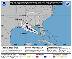
Tropical Depression Nineteen was upgraded to Tropical Storm Sally earlier this afternoon and now is emerging into the Gulf of Mexico. Tropical Storm watches on the Florida east coast have been dropped and a Hurricane Watch and Storm Surge Watch have been issued on parts of the northern Gulf of Mexico coastline as Tropical Storm Sally begins to move away from the west coast of Florida.

SUMMARY OF 0500 PM CDT…2100 UTC…INFORMATION

LOCATION…25.7N 81.9W
ABOUT 30 MI…45 KM SSW OF NAPLES FLORIDA
MAXIMUM SUSTAINED WINDS…40 MPH…65 KM/H
PRESENT MOVEMENT…W OR 280 DEGREES AT 7 MPH…11 KM/H
MINIMUM CENTRAL PRESSURE…1004 MB…29.65 INCHES

SUMMARY OF WATCHES AND WARNINGS IN EFFECT:

A Storm Surge Watch is in effect for…
* Mouth of the Mississippi River to the Alabama/Florida Border
* Lake Pontchartrain, Lake Maurepas, and Lake Borgne
* Mobile Bay

A Hurricane Watch is in effect for…
* Grand Isle Louisiana to the Alabama/Florida border
* Lake Pontchartrain and Lake Maurepas including metropolitan New Orleans

A Tropical Storm Watch is in effect for…
* Alabama/Florida Border to Ochlockonee River Florida<

DISCUSSION:

The following excerpts are from the Forecast Discussion issued at 1700 EDT today, “Sally continues to gradually become better organized, with
developing convective banding features primarily over the southernportion of the circulation at this time. Upper-level outflow is still rather limited over the northern semicircle, possibly due to a weak upper low near the Georgia/Florida border. The latter feature is likely to soon move away from the area, however. Based on earlier scatterometer passes that showed tropical-storm-force winds over the Straits of Florida, the advisory intensity remains 35 kt.  With very warm waters and a moist tropospheric environment ahead of Sally, strengthening seems likely. Some increase in westerly shear over the northern Gulf in 48-72 hours could at least slow down the intensification process around that time. The official intensity forecast is not far from the latest model consensus and a little above the previous forecast.

Fixes from an Air Force Hurricane Hurricane aircraft, radar, satellite, and surface observations indicate a slow, generally westward motion of about 280/6 kt. A weakening mid-level high pressure system to the northeast of Sally should cause a generally west-northwestward to northwestward motion for the next few days.  Because of the weakening steering currents, the cyclone should move rather slowly while it approaches the northern Gulf Coast.  However, there is expected to be enough of a narrow north-south oriented ridge to the east of Sally in 3-4 days to steer the cyclone northward across the coast. The official track forecast has been nudged just slightly west of the previous one and lies
between the simple and corrected dynamical track model consensus predictions.

SITUATION AND ACTIONS:

At the present time Tropical Storm Watches are in effect for Escambia, Santa Rosa, Okaloosa, Bay, Gulf, and Franklin Counties in the Florida Panhandle. The Tropical Storm Watch for the Florida east coast have been discontinued,  At the present time there is only a Flood Watch still in effect until Sunday evening for the entire NWS Ruskin CWA (Coverage Warning Area) extending from Levy County all the way to Lee County on the coast and Polk, Hardee, Highlands and Desoto Counties.  All of the ARRL West Central Florida Section is include in this Flood Watch.  Ther are Flood Warnings for portions of the Peace River in Polk County near Bartow and the Myakka River at Myakka River State Park in Sarasota County.

At the present time, the primary threat to our the ARRL West Central Florida Section continues to be the potential for flooding from possibly excessive rainfall as West Central Florida is on the wetter side of Tropical Storm Sally.  This threat will continue to diminish as Tropical Storm Sally moves away from the State of Florida.  Everyone should continue monitoring the latest advisories issued four times a day by the National Hurricane Center and for any further watches and or warnings issued by the National Weather Service office in Ruskin.on Tropical Depression Nineteen.  All ARES, ACS, and CERT personnel should re-check their supplies and equipment just in case their services are required.

LATEST NATIONAL HURRICANE CENTER INFORMATION:

Public Advisories:  https://www.nhc.noaa.gov/text/refresh/MIATCPAT4+shtml/120243.shtml?
Forecast Advisory:  https://www.nhc.noaa.gov/text/refresh/MIATCMAT4+shtml/120242.shtml?
Forecast Discussion:  https://www.nhc.noaa.gov/text/refresh/MIATCDAT4+shtml/120243.shtml?


The next WCF SECTION SPECIAL BULLETIN on Tropical Storm Sally will issued following the 1700 EDT advisory tomorrow for Tropical Storm Sally, unless conditions warrant a release sooner.

END OF SPECIAL BULLETIN

WCF SECTION SPECIAL BULLETIN #20-10 – 2300 EDT – 9/11/20

TROPICAL DEPRESSION NINETEEN – 2300 EDT – 9/11/20

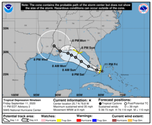
Tropical Depression Nineteen acquired tropical characteristics and the National Hurricane Center began issuing advisories on TD19 at 1700 EDT late this afternoon.  Due to the proximity of Tropical Depression Nineteen, the ARRL West Central Florida Section has begun to issue bulletins on this system. When Tropical Depression Nineteen reaches Tropical Storm strength, the next name on the 2020 Atlantic Hurricane Season is Sally.

SUMMARY OF 1100 PM CDT…2100 UTC…INFORMATION

LOCATION…25.7N 79.8W
ABOUT 25 MI…40 KM ESE OF MIAMI FLORIDA
MAXIMUM SUSTAINED WINDS…35 MPH…55 KM/H
PRESENT MOVEMENT…WNW OR 295 DEGREES AT 8 MPH…13 KM/H
MINIMUM CENTRAL PRESSURE…1007 MB…29.74 INCHES

SUMMARY OF WATCHES AND WARNINGS IN EFFECT:

A Tropical Storm Watch is in effect for…
* South of Jupiter Inlet to north of Ocean Reef
* Ochlockonee River to Okaloosa/Walton County Line

DISCUSSION:

The following excerpts are from the Forecast Discussion issued at 2300 EDT today, “Doppler radar data from Miami and satellite images indicate that the depression is gradually becoming better organized. The low-level center is estimated to be near the northwestern edge of the main area of deep convection due to some northerly wind shear.  Surface observations and satellite classifications support holding the initial intensity at 30 kt. The minimum pressure appears to be a little lower than before, now 1007 mb.

The tropical depression is moving west-northwestward at about 7kt. A subtropical ridge extending from the southeast U.S. to the western Atlantic should steer the depression west-northwestward across south Florida tonight and Saturday morning and then over the eastern Gulf of Mexico late Saturday and Sunday. After that time, the ridge is forecast to weaken due to an approaching trough, but the trough is not expected to be strong enough to cause the cyclone to turn northward. Instead, the models suggest that a slow west-northwestward motion very near the northern Gulf coast is likely during the early and middle portions of next week.  Although the models all show a relatively similar scenario, there is a fair amount of spread by the time the system nears the northern Gulf coast. The NHC track forecast lies roughly near the middle of the guidance envelope close to the consensus aids.  Several of the local National Weather Service forecast offices across the southeast U.S. will be launching weather balloons four times per day, which should provide the models with excellent data in hopes to provide better track guidance during the next couple of days.

Since the depression is expected to move over very warm SSTs, once it reaches the eastern Gulf of Mexico tomorrow, and remain in an
environment of low wind shear and high moisture, gradual strengthening seems likely. The models suggest that there could be an increase in westerly shear around the time the cyclone is forecast to move inland along the northern Gulf coast in about 4 days. Based on these expected environmental conditions, strengthening is forecast during the next few days, and the NHC intensity forecast follows the trend of the IVCN and HCCA models.  The depression will likely be at or near hurricane strength when it reaches the northern Gulf coast.”

SITUATION AND ACTIONS:

At the present time Tropical Storm Watches are in effect for Palm Beach, Broward, Miami-Dade, and Monroe counties on the Florida east coast and Okaloosa, Bay, Gulf, and Franklin Counties in the Florida Panhandle.  At the present time there is only a Flood Watch in effect until Sunday evening for the entire NWS Ruskin CWA (Coverage Warning Area) extending from Levy County all the way to Lee County on the coast and Polk, Hardee, Highlands and Desoto Counties.  All of the ARRL West Central Florida Section is include in this Flood Watch.

At the present time, the primary threat to our the ARRL West Central Florida Section will be the potential for flooding from possibly excessive rainfall as West Central Florida is on the wetter side of Tropical Depresssion Nineteen.  Everyone should continue monitoring the latest advisories issued four times a day by the National Hurricane Center and for any further watches and or warnings issued by the National Weather Service office in Ruskin.on Tropical Depression Nineteen.  All ARES, ACS, and CERT personnel should re-check their supplies and equipment just in case their services are required.

LATEST NATIONAL HURRICANE CENTER INFORMATION:

Public Advisories:  https://www.nhc.noaa.gov/text/refresh/MIATCPAT4+shtml/120243.shtml?
Forecast Advisory:  https://www.nhc.noaa.gov/text/refresh/MIATCMAT4+shtml/120242.shtml?
Forecast Discussion:  https://www.nhc.noaa.gov/text/refresh/MIATCDAT4+shtml/120243.shtml?


The next WCF SECTION SPECIAL BULLETIN on Tropical Depression Nineteen will issued following the 1700 EDT advisory for Tropical Depression Nineteen, unless conditions warrant a release sooner.

END OF SPECIAL BULLETIN

WCF SECTION PRESS RELEASE #20-47

NEW SECTION MANAGER ELECTED FOR THE ARRL WEST CENTRAL FLORIDA SECTION

Mike Douglas W4MDD, the ARRL Affiliated Club Coordinator for the ARRL West Central Florida Section, has been elected as the 4th Section Manager for the ARRL West Central Florida Section.   The nomination period ended on Friday September 4th, and Douglas was the only candidate to submit a nomination form and to be received by ARRL HQ by the end of the nomination period.  Darrell Davis KT4WX, the current Section Manager for the ARRL West Central Florida Section decided not to seek re-election for the 2020-2021 term.  Davis made the following comment concerning the election of Douglas as the new Section Manager, “After praying and thinking about it, I decided not to seek re-election as circumstances in my personal life have changed over the last two years.  I appreciate all of the support that I have received from all of you and I am not ‘riding off into the sunset’.  My role in the ARRL West Central Florida Section will simply be in a supportive role and different.  Mike will do a fine job as our new Section Manager and has traveled all over the ARRL West Central Florida Section with me over the last three years and has gotten to know many of you.  Please give him the same support you have given me.”

Douglas has been a licensed radio amateur since 1991, first holding the callsign of N9OEV, and was previously almost a lifelong resident of the Chicago, Illinois area.  Douglas relocated to Florida in the summer of 2016, following his retirement, and obtained his current callsign of W4MDD.  Douglas became an Assistant Emergency Coordinator with Hardee County ARES in late 2016 after coming to Hardee County from the east coast of Florida.  Douglas then became the ARRL Affiliated Club Coordinator in late 2017.  Douglas in his professional career was commercial tour bus driver, was in commercial bus sales, and for 20 years of his career was with Educational Tours, a tour bus company devoted to providing tours for school age children of educational sites in places all over the United States.

Douglas’ term as Section Manager will begin on January 1, 2021.  Davis has served as Section Manager since January 1, 2015 and his current term as Section Manager will end on December 31, 2020.

END OF PRESS RELEASE

WCF SECTION SPECIAL BULLETIN #20-09 – 1800 EDT – 8/25/20

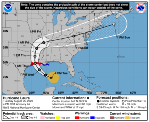
HURRICANE LAURA – 1800 EDT – 8/25/20

Tropical Depression Marco, which was the near the Louisiana coastline yesterday lost nearly all of its convection and showed signs of opening up into an elongated area of low pressure.  As a result the National Hurricane Center issued its last advisory at 0500 EDT today on Tropical Depression Marco as the cyclone no longer meet the criteria of a tropical cyclone.  Now Hurricane Laura is once again alone in the Gulf of Mexico.

SUMMARY OF 400 PM CDT…2100 UTC…INFORMATION

LOCATION…24.7N 88.3W
ABOUT 480 MI…770 KM SE OF LAKE CHARLES LOUISIANA
ABOUT 510 MI…820 KM SE OF GALVESTON TEXAS
MAXIMUM SUSTAINED WINDS…80 MPH…130 KM/H
PRESENT MOVEMENT…WNW OR 300 DEGREES AT 17 MPH…28 KM/H
MINIMUM CENTRAL PRESSURE…990 MB…29.24 INCHES

SUMMARY OF WATCHES AND WARNINGS IN EFFECT:

A Storm Surge Warning is in effect for…
* San Luis Pass Texas to the Mouth of the Mississippi River

A Hurricane Warning is in effect for…
* San Luis Pass Texas to Intracoastal City Louisiana

A Tropical Storm Warning is in effect for…
* Sargent Texas to San Luis Pass
* East of Intracoastal City Louisiana to the Mouth of the
Mississippi River

A Storm Surge Watch is in effect for…
* Freeport Texas to San Luis Pass
* Mouth of the Mississippi River to Ocean Springs Mississippi
* Lake Pontchartrain, Lake Maurepas, and Lake Borgne

A Hurricane Watch is in effect for…
* East of Intracoastal City to west of Morgan City Louisiana

DISCUSSION:

The following excerpts are from the Forecast Discussion issued at 1700 EDT today, “Satellite imagery shows some changes in the convective pattern of Laura since the last advisory. The ragged central dense overcast seen earlier has been replaced by a curved convective band that
wraps almost all the way around a cloud-filled banding-type eve. One possible reason for this change is that the imagery also suggests a
tongue of dry air is trying to entrain into the cyclone just west of the central convection. Aircraft data received after the last advisory did not show any fall in the central pressure, but did have high enough flight-level and SFMR winds to justify nudging the initial intensity up to 70 kt.

The initial motion is now west-northwestward or 300/15 kt. There is no change in the forecast philosophy since the last advisory. The hurricane is currently on the south side of a large-deep layer ridge over the southeastern United States, and it is moving toward a break in the ridge caused by mid- to -upper-level troughing over Texas and the southern Great Plains. The current and forecast synoptic pattern should steer Laura west-northwestward this evening, followed by a turn toward the northwest tonight and toward the north by Wednesday night and Thursday. This will result in the hurricane making landfall in the area of southwestern Louisiana or the upper Texas coast late Wednesday night or Thursday morning. The new forecast track has a slight eastward nudge during the first 12-24 h, but the landfall position is almost unchanged from that of the previous forecast. It should the be noted that the current forecast track lies to the east of the ECMWF and UKMET models, so it is still
possible that the forecast track could nudge westward in later advisories. After landfall, Laura is expected to recurve into the westerlies and move eastward through the Tennessee Valley and the mid-Atlantic States before reaching the Atlantic in about 120 h.”


SITUATION AND ACTIONS:

At the present time all Tropical Storm Watches and Tropical Storm Warnings for the entire State of Florida have been discontinued due to Hurricane Laura heading away from the State of Florida.  Hurricane Laura will make landfall most likely in either the eastern Texas or western Louisiana coastline late tomorrow evening or early on Thursday morning.

Everyone should continue or resume their normal monitoring of the latest Tropical Weather Outlook issued four times a day by the National Hurricane Center and continue to monitor the latest advisories on Hurricane Laura.  The Hurricane Watch Net will activate tomorrow morning on 14325 KHz and or 7268 KHz to receive weather reports of interest to the National Hurricane Center and relay of any emergency or priority traffic.  For more information go to the following ARRL News Release:  http://www.arrl.org/news/hurricane-watch-net-firms-up-wednesday-activation-plans.

LATEST NATIONAL HURRICANE CENTER INFORMATION:

Public Advisories:  https://www.nhc.noaa.gov/text/refresh/MIATCPAT3+shtml/222347.shtml
Forecast Advisory:  https://www.nhc.noaa.gov/text/refresh/MIATCMAT3+shtml/222051.shtml?
Forecast Discussion:  https://www.nhc.noaa.gov/text/refresh/MIATCDAT3+shtml/222052.shtml?


Due to the threat to the State of Florida being diminished from Hurricane Laura, this will be the final WCF SECTION PRESS RELEASE on Hurricane Laura unless conditions warrant resumption of these press releases.

END OF SPECIAL BULLETIN

WCF SECTION SPECIAL BULLETIN #20-08 – 1800 EDT – 8/24/20

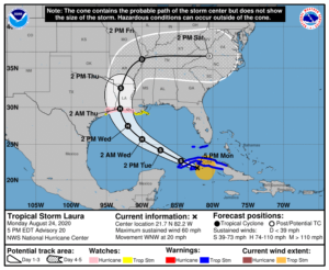
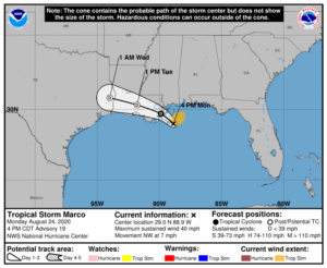
TROPICAL STORM LAURA AND TROPICAL STORM MARCO – 1800 EDT – 8/24/20

This bulletin will primarily focus on Tropical Storm Laura, which is still in close proximity to the State of Florida but forecast to impact only the Florida Keys.  The information on Tropical Storm Marco is presented for information purposes only.

SUMMARY OF 500 PM EDT…2100 UTC…INFORMATION

LOCATION…21.7N 82.2W
ABOUT 40 MI…65 KM E OF THE ISLE OF YOUTH
ABOUT 175 MI…280 KM E OF THE WESTERN TIP OF CUBA
MAXIMUM SUSTAINED WINDS…60 MPH…95 KM/H
PRESENT MOVEMENT…WNW OR 290 DEGREES AT 20 MPH…31 KM/H
MINIMUM CENTRAL PRESSURE…1001 MB…29.56 INCHES

SUMMARY OF WATCHES AND WARNINGS IN EFFECT:

A Storm Surge Watch is in effect for…
* San Luis Pass Texas to Ocean Springs Mississippi
* Lake Pontchartrain, Lake Maurepas, and Lake Borgne

A Hurricane Watch is in effect for…
* Port Bolivar Texas to west of Morgan City Louisiana

A Tropical Storm Warning is in effect for…
* Cuban provinces of Ciego De Avila, Sancti Spiritus, Villa Clara, Cienfuegos, Matanzas, Mayabeque, La Habana, Artemisa, Pinar del
Rio, and the Isle of Youth
* Florida Keys from Craig Key to Key West
* Dry Tortugas

A Tropical Storm Watch is in effect for…
* South of Port Bolivar to San Luis Pass Texas
* Morgan City Louisiana to the Mouth of the Mississippi River

DISCUSSION

The following is excerpts from the Forecast Discussion at 1700 EDT, “The satellite presentation of the tropical storm has improved
somewhat with deep convection remaining over the center, and an increase in banding over the southeastern portion of the circulation. Earlier aircraft and scatterometer data, however, indicated that there has been little change in strength today, and the initial intensity remains 50 kt. These observations have shown the the stronger winds are located in the convective band well east and southeast of the center, and that the system currently lacks an inner core. This is likely the reason that Laura has not been able to strengthen while it has moved over water today. Theaircraft also reported a fairly stable minimum pressure of 1001-1003 mb during its mission this morning and early afternoon.

The intensity forecast philosophy remains the same as the previous advisory. Once Laura moves over the southeastern Gulf of Mexico tonight, a combination of warm sea surface temperatures and low vertical wind shear should allow for steady strengthening. The latest iterations of the global and regional hurricane models continue to show significant deepening while Laura traverses the Gulf of Mexico, and a period or rapid strengthening is possible once an inner core is able to organize. The statistical guidance is again on the lower side of the intensity forecast envelope while the HWRF and CTCI models bringing Laura to major hurricane strength. The NHC intensity forecast is again between these
solutions and is close to the consensus aids.

The initial motion estimate is 290/16 kt. A deep-layer ridge over the western Atlantic is expected to build westward during the next day or so. By early Wednesday, a mid- to upper-level trough over the south-central United States is forecast to erode the western portion of the ridge, which should cause Laura to turn northwestward and then northward toward the northwestern Gulf coast. After landfall, Laura or its remnants are expected to become embedded in the mid-latitude westerlies and recurve over the eastern U.S.on days 4 and 5.”

SITUATION AND ACTIONS:

At the present time Tropical Storm Warnings are in effect for the Florida Keys from Craig Key to Key West and the Dry Tortugas in the State of Florida as Laura is due to pass close to the Florida Keys on Tuesday before heading in the the central and western Gulf of Mexico away from the State of Florida for eventual landfall most likely on the western coast of Louisiana on Thursday.

As of press time, there are no requests for activation from any of our served agencies in the ten counties of the ARRL West Central Florida Section.  Manatee County ARES returned to a no activation status from a Level 3 activation (stand by) due to any requests for assistance not being anticipated for this incident.  All ARES, ACS, and CERT personnel should continue to monitor the latest National Hurricane Center advisories on Tropical Storm Laura while the storm is in close proximity to the State of Florida.

LATEST NATIONAL HURRICANE CENTER INFORMATION:

Public Advisories:  https://www.nhc.noaa.gov/text/refresh/MIATCPAT3+shtml/222347.shtml
Forecast Advisory:  https://www.nhc.noaa.gov/text/refresh/MIATCMAT3+shtml/222051.shtml?
Forecast Discussion:  https://www.nhc.noaa.gov/text/refresh/MIATCDAT3+shtml/222052.shtml?


The next WCF SECTION SPECIAL BULLETIN on Tropical Storm Laura will be issued following the 1700 EDT advisory on Tropical Storm Laura unless conditions warrant a sooner release.  If the forecast track holds, tomorrow’s bulletin will be the final WCF SECTION PRESS RELEASE on Tropical Storm Laura.

END OF PRESS RELEASE


WCF SECTION SPECIAL BULLETIN #20-07 – 1800 EDT – 8/23/20

TROPICAL STORM LAURA AND HURRICANE MARCO – 1800 EDT – 8/23/20

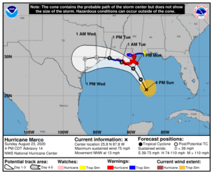
Since our last WCF SECTION SPECIAL BULLETIN yesterday Tropical Storm Marco entered the Gulf of Mexico and has become a category 1 hurricane.  There is a good possibility that by Tuesday we will have one hurricane and one tropical storm in the Gulf of Mexico at the same time, which is somewhat rare.  There is a possibility that Tropical Storm Laura could obtain category 1 hurricane status as Hurricane Marco is making landfall on the northern Gulf coast, which will allow us to see two hurricanes in the Gulf of Mexico at the same time, which has not been seen since modern records have been kept for over the past 100 years.   Information on Hurricane Marco has been included for information purposes only.
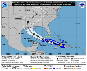
TROPICAL STORM LAURA:  SUMMARY OF 500 PM EDT…2100 UTC…INFORMATION

LOCATION…19.5N 75.2W
ABOUT 50 MI…80 KM S OF GUANTANAMO CUBA
ABOUT 220 MI…350 KM SE OF CAMAGUEY CUBA
MAXIMUM SUSTAINED WINDS…60 MPH…95 KM/H
PRESENT MOVEMENT…WNW OR 285 DEGREES AT 21 MPH…33 KM/H
MINIMUM CENTRAL PRESSURE…1000 MB…29.53 INCHES

TROPICAL STORM LAURA:  SUMMARY OF WATCHES AND WARNINGS IN EFFECT:

A Tropical Storm Warning is in effect for…
* Entire coast of the Haiti
* Inagua and the Ragged Islands in southeastern Bahamas
* Little Cayman and Cayman Brac
* Cuban provinces of Camaguey, Las Tunas, Holguin, Guantanamo,
Santiago de Cuba, Granma, Ciego De Avila, Sancti Spiritus, Villa
Clara, Cienfuegos, Matanzas, Mayabeque, La Habana, Artemisa, Pinar
del Rio, and the Isle of Youth

A Tropical Storm Watch is in effect for…
* Florida Keys from Craig Key to Key West and the Dry Tortugas


HURRICANE MARCO: SUMMARY OF 400 PM CDT…2100 UTC…INFORMATION

LOCATION…25.8N 87.8W
ABOUT 240 MI…390 KM SSE OF THE MOUTH OF THE MISSISSIPPI RIVER
ABOUT 395 MI…640 KM SE OF LAFAYETTE LOUISIANA
MAXIMUM SUSTAINED WINDS…75 MPH…120 KM/H
PRESENT MOVEMENT…NNW OR 340 DEGREES AT 13 MPH…20 KM/H
MINIMUM CENTRAL PRESSURE…991 MB…29.27 INCHES

HURRICANE MARCO: SUMMARY OF WATCHES AND WARNINGS IN EFFECT:

A Storm Surge Warning is in effect for….
* Morgan City Louisiana to Ocean Springs Mississippi
* Lake Borgne

A Hurricane Warning is in effect for…
* Morgan City Louisiana to the Mouth of the Pearl River

A Storm Surge Watch is in effect for…
* Sabine Pass to Morgan City Louisiana
* Ocean Springs Mississippi to the Mississippi/Alabama border
* Lake Pontchartrain and Lake Maurepas

A Hurricane Watch is in effect for…
* Intracoastal City to west of Morgan City
* Lake Pontchartrain, Lake Maurepas, and Metropolitan New Orleans

A Tropical Storm Warning is in effect for…
* Mouth of the Pearl River to the Mississippi/Alabama border
* Lake Pontchartrain, Lake Maurepas, and Metropolitan New Orleans
* Cameron to west of Morgan City

A Tropical Storm Watch is in effect for…
* Mississippi/Alabama border to the Alabama/Florida border


DISCUSSION:

The following are excerpts from the Forecast Discussion of Tropical Storm Laura:

“Satellite imagery and radar data from eastern Cuba show that the center of Laura has been moving over water between Haiti and eastern Cuba this afternoon. There has been a recent uptick in convection near the center and the radar imagery has shown an increase in banding. An Air Force reconnaissance aircraft investigating Laura this afternoon has reported a minimum pressure that has fallen to around 1000 mb, and winds to support an intensity of 50 kt. The plane very recently found a small area of stronger flight-level winds, but these winds may be associated with mesocyclone, and not representative of the large scale circulation.

Laura continues to move briskly west-northwestward or 285/18 kt. The track forecast reasoning remains the same as the previous advisory. Laura should continue to move west-northwestward to the south of a deep-layer ridge that is forecast to build westward across Florida and the eastern Gulf of Mexico during the next day or two. The track guidance has continued to edge southward for the portion of the forecast near Cuba, and the NHC forecast has again been moved in that direction. Laura should continue moving west-northwestward over the southeastern Gulf on Tuesday, but a turn toward the northwest is expected Tuesday night as the cyclone nears the western portion of the ridge. A northwestward to north-northwestward motion should then continue around the western portion of the ridge until the cyclone reaches the northwestern Gulf coast. The latest run of the ECMWF has shifted significantly eastward, however its ensemble mean and many of the stronger ensemble members remain farther west as a stronger cyclone is likely to be steered more westward by the deep-layer ridge. The GFS, UKMET, and HWRF remain close to the previous NHC track, so little change was made to the official forecast was made after 48 hours.”

SITUATION AND ACTIONS:

At the present time there are no Tropical Storm Warnings for the State of Florida.  There are Tropical Storm Watches in effect for the Florida Keys from Craig Key to Key West and the Dry Tortugas.

As of press time, only one county in the ARRL West Central Florida Section has an ARES group on a Level 3 activation, which is a stand by mode:  Manatee County. As of press time, there are no other ARES groups on any activation level.  All ARES, ACS, and CERT personnel should continue to monitor the latest National Hurricane Center advisories on Tropical Storm Laura while the storm is in close proximity to the State of Florida.

LATEST NATIONAL HURRICANE CENTER INFORMATION:

Public Advisories:  https://www.nhc.noaa.gov/text/refresh/MIATCPAT3+shtml/222347.shtml
Forecast Advisory:  https://www.nhc.noaa.gov/text/refresh/MIATCMAT3+shtml/222051.shtml?
Forecast Discussion:  https://www.nhc.noaa.gov/text/refresh/MIATCDAT3+shtml/222052.shtml?


The next WCF SECTION SPECIAL BULLETIN on Tropical Storm Laura will be issued following the 1700 EDT advisory on Tropical Storm Laura unless conditions warrant a sooner release.

END OF PRESS RELEASE
WCF SECTION SPECIAL BULLETIN #20-06 – 1800 EDT – 8/22/20

TROPICAL STORM LAURA – 1800 EDT – 8/22/20

With this advisory, the ARRL West Central Florida Section commences WCF SECTION SPECIAL BULLETIN releases on the latest status of Tropical Storm Laura, which was upgraded from Tropical Depression Thirteen yesterday, Friday August 21, 2020.

Tropical Storm Laura remains on a steady westerly track going around the periphery of the western Atlantic high pressure ridge which is now in the strengthening phase and thus is keeping Tropical Storm Laura away from the State of Florida at the present time.   The forecast track has shifted consistently south of the State of Florida for two days.

SUMMARY OF 500 PM AST…2100 UTC…INFORMATION

LOCATION…18.0N 68.1W
ABOUT 100 MI…160 KM W OF PONCE PUERTO RICO
ABOUT 125 MI…200 KM ESE OF SANTO DOMINGO DOMINICAN REPUBLIC
MAXIMUM SUSTAINED WINDS…50 MPH…85 KM/H
PRESENT MOVEMENT…W OR 280 DEGREES AT 18 MPH…30 KM/H
MINIMUM CENTRAL PRESSURE…1004 MB…29.65 INCHES

SUMMARY OF WATCHES AND WARNINGS IN EFFECT:

A Tropical Storm Warning is in effect for…
* Puerto Rico, Vieques and Culebra
* U.S. Virgin Islands
* The northern coast of the Dominican Republic from Cabo Engano to the border with Haiti
* The southern coast of the Dominican Republic from Cabo Engano to Punta Palenque
* The northern coast of Haiti from Le Mole St. Nicholas to the border with the Dominican Republic
* The southeastern Bahamas and the Turks and Caicos Islands
* Cuban provinces of Camaguey, Las Tunas, Holguin, Guantanamo, Santiago de Cuba, and Granma

A Tropical Storm Watch is in effect for…
* The central Bahamas
* Andros Island
* Florida Keys from Ocean Reef to Key West and the Dry Tortugas
* Florida Bay

A Tropical Storm Watch means that tropical storm condition

DISCUSSION

The following excerpts are from the Forecast Discussion issued at 1700 EDT on Tropical Storm Laura, “A couple of hours ago an observing site on the southeast coast of Puerto Rico, Las Mareas, reported sustained winds of 52 kt. These winds were apparently associated with a mesocyclone embedded within the larger-scale circulation and not representative of the intensity of the tropical storm. Scatterometer data and WSR-88D Doppler velocities from San Juan support an intensity of 45 kt. Since the center should be moving over land for the next 48 hours or so, no additional intensification is anticipated until Monday night when the center moves over the southeastern Gulf of Mexico. Over warm waters, with anticipated weak vertical shear, and anticyclonic flow aloft, Laura will likely strengthen into a hurricane before it reaches the northern Gulf of Mexico coast. The NHC intensity forecast is close to the multi-model consensus, but given the possibility of a favorable upper-air  environment over the Gulf, this forecast could be conservative. At this time it does not seem likely that Marco, which is forecast to make landfall on the north-central Gulf coast a day or two earlier than Laura, should have much of an influence on the latter system.

Center locations from earlier scatterometer data, low-cloud motions, and Dvorak fixes from both TAFB and SAB, give a motion of about 280/16 kt. Laura should move west-northwestward along the southern side of a mid-tropospheric anticyclone centered near the southeastern U.S. coast through 72 hours. Then, the cyclone is expected to turn northwestward to northward on the western side of the high. The official track forecast is on the right side of the track guidance suite.”

SITUATION AND ACTIONS:

At the present time there are no Tropical Storm Warnings for the State of Florida.  There are Tropical Storm Watches in effect for the Florida Keys and Florida Bay only.  This watch will no doubt be upgraded to a Tropical Storm Warning as Laura approaches the Florida Keys.

As of press time, only one county in the ARRL West Central Florida Section has an ARES group on a Level 3 activation, which is a stand by mode:  Manatee County. As of press time, there are no other ARES groups on any activation level.  All ARES, ACS, and CERT personnel should continue to monitor the latest National Hurricane Center advisories on Tropical Storm Laura while the storm is in close proximity to the State of Florida.

LATEST NATIONAL HURRICANE CENTER INFORMATION:

Public Advisories:  https://www.nhc.noaa.gov/text/refresh/MIATCPAT3+shtml/222347.shtml
Forecast Advisory:  https://www.nhc.noaa.gov/text/refresh/MIATCMAT3+shtml/222051.shtml?
Forecast Discussion:  https://www.nhc.noaa.gov/text/refresh/MIATCDAT3+shtml/222052.shtml?


The next WCF SECTION SPECIAL BULLETIN on Tropical Storm Laura will be issued following the 1700 EDT advisory on Tropical Storm Laura unless conditions warrant a sooner release.

END OF PRESS RELEASE
WCF SECTION PRESS RELEASE #20-46

THE WCF PRESSER ISSUE #52 FOR AUGUST 2020 IS NOW PUBLISHED

The WCF PRESSER Issue #52 for August 2020, has been published on the Section website.  An announcement of the publication of the WCF PRESSER will be disseminated on the ARRL remailer shortly. If anyone has any information that is amateur radio related that you would like to go into the next issue of THE WCF PRESSER, please send that to our newsletter editor, Jim Weslager K3WR via email at weslager@gmail.com.

For the PDF version of this newsletter and past issues in PDF format go to http://arrlwcf.org/home/the-wcf-section-presser-arrl-west-central-florida-section-news/.

END OF PRESS RELEASE

WCF SECTION PRESS RELEASE #20-45

NVIS TEST PLANNED FOR 8/22/20 IN HIGHLANDS COUNTY

Doug Young KM4LKC will be traveling to Highlands Hammock State Park, located on the west side of Sebring, on Saturday August 22, 2020 to conduct an NVIS communications test between Highlands County and Charlotte County from 1000 EDT until 1300 EDT.  Several stations in Charlotte County are planning to operate for the NVIS test.  Operations are planned on 80/75 Meters, 40 Meters, and 20 Meters both on SSB Phone and on digital via JS8 Call.  Young is requesting that any and all stations to participate either from their base station at home, mobile, and those who feel inclined are encouraged to go out to a local park and operate NVIS portable
Listed below is a tentative operating schedule for the NVIS communications test:
1000 EDT:  3.915 +/-  LSB Phone
1030 EDT:  3.578  JS8
1100 EDT:  14.280 +/- USB Phone
1130 EDT:  14.078  JS8
1200 EDT:  7.280 +/- LSB Phone
1230 EDT:  7.078 JS8
Updates will be posted on the Charlotte Amateur Radio Society’s groups.io page (which is open to everyone for viewing).
See the information post on the NVIS test at https://cars-fl.groups.io/g/main/message/756.

END OF PRESS RELEASE


WCF SECTION PRESS RELEASE #20-44

WCF SECTION TECHNICAL NET GETS NEW NET MANAGER

Darrell Davis KT4WX, Section Manager of the ARRL West Central Florida Section, has appointed Jim Peterson AF2W as the Net Manager for the ARRL West Central Florida Section Technical Net.  Peterson succeeds Burt Wizeman K4SRQ, who recently stepped down as Net Manager due to work and family commitments.

Davis made the following comments about the appointment of Peterson as Net Manager of the ARRL West Central Florida Technical Net, “Jim has extensive experience as net control, net manager, and also served on numerous occasions as NCS for the WCF Technical Net over the last year.  Jim will make an excellent net manager for the WCF Section Technical Net.”

Peterson was first licensed in March of 1993 as KC2BGJ and soon upgraded to General and Extra class.  Peterson then applied for and was granted the callsign of K2CSS, which stands for the first letter of the names of his three children, Catlin KC2OAR, Shannon, and Steven. Peterson became involved in the National Traffic System, serving as net control for several nets and then served as the Section Traffic Manager for the ARRL Eastern New York Section.  Peterson was also involved with his local ARES/RACES group, participating in helping with communications for several public service events including the Empire State Games.  Peterson assisted with communications for the American Red Cross in the aftermath of the September 11, 2001 attack on New York City.  After relocating to Florida a few years ago, Peterson became involved in the Eagle Net, the NTS traffic net for the ARRL West Central Florida Section, and soon after became the Thursday evening NCS and an Assistant Net Manager.  Peterson after relocating to Florida also applied and was granted his current callsign of AF2W

Peterson in his professional career has worked as an elevator adjuster, which involves providing programming and technical support for elevator maintenance, for 30 years.  Peterson has been married to his wife Tara N2CSS for 28 years and has three children:  Caitlin KC2OAR an army veteran and registered nurse, Shannon who is a medical receptionist and currently in college, and Stephen who is a dispatcher for the Hernando County Sheriff’s Office.

END OF PRESS RELEASE

1 16 17 18 19 20 49